The designed landscape at Boynton is of particular historic interest because it retains elements of three main periods of activity from the early 18th to early 19th century. Although the parkland has been reduced the plantations in the wider designed landscape cover much the same area as they did in the mid 19th century. The surviving built features of the landscape, the garden (banqueting) house of c. 1600, the early 18th-century bridge, and the mid-late 18th century dairy, Fond Bridge and Carnaby Temple are particularly significant and rare in the East Riding.
Parts of the landscape adjoining Woldgate feature in many of David Hockney’s paintings, drawings and films 2005-2013.
Estate owners
As sub-tenants of various overlords the Boynton family were, from the late 11th century, the effective lords of Boynton. The lands were evidently held by two branches of the family, and it was through the Boyntons of Hunmanby that the manor of Boynton passed through an heiress to John Newport in 1419. (Purdy, ‘Boynton’, 23-25; Collier, Account of the Boynton Family, 1, 43-50.) The Newports evidently made their home at Boynton and were buried in the parish church.
In 1549 the manor was acquired from Thomas Newport by William Strickland, and it remained in the hands of the Strickland family until sold by James E. Strickland in 1951 to J.T.T. Fletcher. The following year the hall and some 715 acres were sold by Fletcher to J. Taylor Ltd, timber merchants of Driffield. (Purdy, ‘Boynton’, 23.) The hall was purchased by W.S. Cook in 1954, and he sold it to Richard Marriott (nephew of the last Strickland owner) and his wife Sally in 1981 (Inf. Richard Marriott).
The hall was a principal residence of the Strickland family from the late 16th century until the early 20th century. The owners most active in planting and laying out the grounds were:
Sir Wiliam Strickland, 3rd Bt (1665-1724) – Owner 1684-1724
Sir William Strickland, 4th Bt (c. 1686 - 1735) - Owner 1724-1735
Sir George Strickland, 5th Bt (1729-1808) – Owner 1735-1808
Sir William Strickland, 6th Bt (1753-1834) – Owner 1808-1834
Early history of the site
It is not known where the Boynton family had their ‘capital messuage’ or manor house, first mentioned c. 1200, but it is probable that it was on the site of the present Boynton Hall. (Purdy, ‘Boynton’ , 24; Collier, Account of the Boynton Family, 46.) The stone built ‘great hall’ and the south-west corner (solar?) of the present house are considered to date from the 15th century (Information from Adrian Green and Tim Schadla-Hall, 2008).
Excavations carried out in the lawn at Boynton Hall over recent years by Tim Schadla-Hall and Adrian Green have revealed clues to the layout of the pre-18th century gardens but these have yet to be fully interpreted. The only visible pre-18th century garden feature is the Garden House situated at the south-west corner of the large lawn to the south and west of the Hall. The small square brick building with stone dressings was probably built c. 1600. It consists of a basement with room above reached by external steps and may have served as a banqueting house with access to the roof which would provide a viewing area over what would have been a formal garden.
Chronological history of the designed landscape
Late 17th-early 18th century
The first evidence for the layout of the gardens comes from a view of Boynton Hall from the south drawn by Samuel Buck c. 1720 and a later copy of a plan of Boynton drawn c. 1725. (BL, Lansdowne Mss ; Photograph of plan in Strickland Mss in Canada, copy provided by Adrian Green. It was made before 1730 and the death of Sir Griffith Boynton whose lands are marked, and certainly after the accession of Sir William Strickland, 4th Bt. in 1724.) These give some indication of the appearance of the grounds at the end of the life of Sir William Strickland, 3rd Bt. who inherited the estate in 1684.
Sir William modernized interior of the house in 1700-4, replacing the main staircase and evidently moving the main entrance to the central bay of the south or garden front. It is very likely that he carried out changes to the grounds around this time.
Samuel Buck’s view of Boynton Hall from the south shows the house set in a large walled enclosure with two ranges of buildings to the right. There are trees in the foreground and to the upper far left and right, corresponding roughly to the location of trees on the plan of c. 1725.
A broad gateway with substantial decorative gatepiers centred on the new central entrance to the house pierces the garden wall leading to a break in the trees and a possible avenue. This location corresponds exactly with the position of the so-called Hollow Road, a broad sunken pathway that still exists.
The Hollow Road is clearly shown on Ordnance Survey maps from 1854 onwards. The gatepiers that are now located at right angles to their original position, leading to the Dairy Cottage, are of c. 1700, or a decade to either side, which suggests that the Hollow Road may also be of this date.
The ‘Hollow Road’ and the gateway are not shown on the plan of c. 1725, nor is the walled garden enclosure clearly marked. There are, however, other features on the plan that suggest that the gardens had been re-ordered in the late 17th or early 18th century. First the way the gardens are divided into separate, roughly rectangular compartments including what are probably an orchard, in four segments, and a kitchen garden (located where the present walled garden is). Directly north of the house a broad lawn (?) leads up to the medieval church forming an eyecatcher. To the east of the lawn is an avenue of trees centred on the broad village street and ending on a pond created by broadening the Gypsey Race. This caused a diversion to be made of the road from Boynton to Carnaby which was given a new bridge over the Gypsey Race.
Further east, to the east of the lawn, the Gypsey Race was formed into a long rectangular canal, a typical garden feature of the period (e.g. Westbury Court, Gloucestershire 1695-1705). If the plan is nearer 1730 in date than is suggested above it could show changes to the gardens carried out by Sir William Strickland 4th baronet after his accession in 1724.
1720s-1730s
Sir William Strickland, 4th baronet, an active MP like his father, rose to prominence in government obtaining the posts of Treasurer to the Queen 1720-30, a lord of the Treasury 1725-7 and Secretary at War 1730-35. Sir William, who sought advice from Lord Burlington for the improvements to Boynton Hall, employed William Kent to design fireplaces for the house, and knew the architects Hawksmoor and Vanburgh, was very likely to have had schemes to make the layout of the gardens and landscape at Boynton more fashionable. (Pevsner & Neave, Yorkshire, York and the East Riding, 334-5; Sinclair, ‘Sir William Strickland’s Hunting Lodge’, 196-7; Strickland was also a subscriber for The Designs of Inigo Jones published by William Kent (1727) and A Book of Architecture by James Gibbs (1728). As Treasurer of the Queen he came into contact with landscape designer Charles Bridgeman, and amongst Strickland’s papers in Canada are records of payments made to Bridgeman for work in St James’ Park, Richmond Lodge and the Royal Paddock, Kensington. (Information from Adrian Green) Bridgeman was also employed by Strickland’s father-in-law Sir Jeremy Sambrooke at Gubbins (Gobions or More Hall) in Hertfordshire and by his cousin Sir William St Quintin at nearby Scampston. (Willis, Charles Bridgeman, 2002, 61, 86-7, 182, 428, 434; Neave & Turnbull, Landscaped Parks, 62, 64)
Although there is no record of the 4th baronet carrying out any garden design he did improve the landscape by planting trees and experimenting with new agricultural crops such as sainfoin, clover and lucerne with the help of his steward at Boynton, John Sayer. Both Sayer and John Carr, Sir William’s steward at Malton, were subscribers to The Practical Husbandman and Planter (1733) produced by the garden designer Stephen Switzer. An account of Sir William’s pioneering planting was provided by his grandson Henry E. Strickland in his A General View of the Agriculture of the East Riding of Yorkshire (1812):
About the year 1725, Sir William Strickland of Boynton, received some larch-trees from Switzerland, in number probably about an hundred. These were planted in small detached clumps, (in situation then very exposed, without any protection from surrounding trees,) in good, but very dry ground, with chalk very near the surface. Of these thirty-one are now remaining, all in perfect health, and will appear from the following measurements to be still in their full growth … These trees are supposed to be the parent-stock of most of the larch-trees in North of England; the nursery-gardeners, about the middle of the last century, having got the cones from them before they were able to procure a supply elsewhere: and between forty and fifty years ago, a quantity of cones were annually sent for several successive years to the late Sir George Savile, for making his great plantations at Rufford, in Nottinghamshire, … a sufficient proof of their general scarcity at that time. (Strickland, General View, 137-8.)
The location of the larch clumps is unknown.
After Sir William’s early death in 1735, and during the minority of his son Sir George Strickland, 5th Bt, born 1729, the estate was overseen by ‘Mr’ Draper, possibly Daniel Draper, who in 1749 provided an account of the state of the gardens and plantations. He reported that ‘the walls contain 209 fruit trees of different kinds’; on the walls there were peach, nectarine and apricot trees and the garden contained plum, pear and cherry trees as well as gooseberry and currant bushes. The trees were probably against the walls of the garden enclosure on the south side of the house where trees are shown in Buck’s view of c. 1720. The wall trees had suffered from severe winters, blight and insects.
Draper wrote of the ‘plantations which I disposed and planted’ that ‘now form a canopy to shade me and are in a flourishing condition, many of the early planted being from 25 to 39 feet high’ (Strickland Mss in Canada, information from Adrian Green, 2012).
Late 18th century
The portrait of Sir George Strickland and his wife Elizabeth daughter of Sir Rowland Winn, 4th Bt. of Nostell by Arthur Devis was painted in 1751 and has traditionally been said to show them in the grounds of Boynton Hall. The couple were not married until November 1751 and this may have been painted before their marriage. It is probably an idealised landscape and unlikely to be the grounds of Nostell Priory where Sir Rowland developed his parkland in ‘a naturalistic style’ from the late 1750s, creating lakes and planting trees. (Raikes & Knox, Nostell Priory and Parkland, 45.)
Sir George Strickland was evidently busy planting trees at Boynton at much the same time because a contemporary commented in 1757 that ‘Sir George ‘minds nothing but planting children and trees’. (Neave & Turnbull, Landscaped Parks, 20) It was later that he turned to more extensive changes to the landscape, after first beginning alterations to the house where he employed the architect John Carr from 1765. Carr was almost certainly responsible for the rebuilding of the nave and chancel of the village church in 1768. (Pevsner & Neave, Yorkshire, York and the East Riding, 333-4) Boynton was visited in 1768 by the agricultural writer Arthur Young, who unfortunately made no comments about the landscape or plantations only praising Sir George’s attempts at setting up a woollen manufactory on the edge of the park and his experiments with sainfoin. It was in 1768 that Sir George appears to have begun his transformation of the setting of Boynton Hall, because that year he obtained permission to move two roads away from close proximity to the Hall. The road from Bridlington to Rudston (and on to York) was moved further north to its present position, and the road from Carnaby to Boynton was moved further west. (Purdy, ‘Boynton’, 22) A dozen village houses along the old Bridlington to Rudston road were removed.
This would have led to the re-ordering of the landscape around the house in a more picturesque style. The ‘canalised’ stretch of the Gypsey Race to the north and west of the house was widened and returned to its more natural curving route. The walled kitchen garden was probably rebuilt and an arched arcade built along its east wall, the “Gothick” dairy was built and the garden room was Gothicised.
Sir George Strickland evidently also embarked on large-scale planting at this time. His son recorded in 1812 that Sir George, along with others, had made ‘very extensive plantations’ upon the Wolds ‘about forty years ago’ (c. 1770). (Strickland, General View, 177) He also noted that :
Many thousands of the red larch (Larix rubra), a native of the northern parts of America, have been planted at Boynton of late years, the produce of a single tree planted there about thirty-five years ago ….. Here, also, a considerable number of the Norway maple (Acer Plantanoides) the most beautiful of its genus, have been propagated with success, as the soil appears favourable to them, and they multiply spontaneously from seed. Many other curious exotic forest-trees and shrubs, may, also, be found at this place.’ ( Strickland, General View, 138)
Jefferys’ plans of 1772 and 1775 show sizeable plantations on the Wolds to the south and south-west of Boynton Hall, in the present locations of Sands Wood and Fishpond Wood. The plan does not show any fishponds in the latter area, and it is possible that they were constructed later than 1775. They are shown on Teesdale’s map surveyed 1817-18.
The map that has been tentatively dated to c. 1725 shows the future area of Fishponds Wood as enclosed, probably recently, and divided into a series of rectangular fields in the ownership of Sir William Strickland and four freeholders. Part of the area is called East Ings, usually indicating a low lying wet area.
It is probable that Sir George would not have been able to complete his landscaping and planting schemes until he had secured ownership of the whole parish of Boynton, which he did by 1783, except for 8 acres held by the vicar, and the inclosure of the open fields that was completed the same year. (Purdy, ‘Boynton’, 26)
The diarist Dorothy Richardson provides a description of the landscape at Boynton in 1801. She notes that when
ascending the hill’, going south from the house, there was on the right hand ‘a broad extensive plantation (Sands Wood) continuing a long way & a plantation on the left (Fishpond Wood) to the left before we reached to top. (John Rylands Library, English MS 1126, 52-3.)
On another visit a few days later she recorded that
‘a hill rises quick south of the house which we ascended in nearly a straight line upon the grass, thro’ the most beautiful wooded scene I ever saw consisting of noble single trees, small groups of trees, & groups of laburnums, mountain ash,&c & bounded to the right by thick wood. Looking back, after we had ascended about half the hill, the house appears to advantage with a background of wood. (ibid, 186-7)
The object of her walk was the ‘Temple of Aolus on the very summit of the hill’; this was Carnaby Temple, probably designed by John Carr and built for Sir George Strickland c. 1772. An eyecatcher, it also provided the destination for those on a walk through the grounds from Boynton. Dorothy Richardson described the view north from the Temple as:
enriched by Sr George Stricklands extensive plantations but we criticized one descending a Hill north of the House, & which from the Temple is planted in squares with grass vistas betwixt in as formal a manner as a garden parterre in King Williams reign. (ibid, 190)
An alternative return route from the temple would be through Hallowkiln (Hallookill) Wood, an extension of Fishpond Wood, to the south of Woldgate in Carnaby parish. Not marked on Jefferys 1775 plan it was probably planted by Sir George Strickland soon after. It is marked on Teesdale’s plan surveyed 1817. A footpath led from Carnaby Temple into Hallowkiln Wood, then under Woldgate, via Fond Bridge (see below) into Fishpond Wood and on to Boynton Hall possibly by the Hollow Road for the last stretch. ond Bridge, with its tunnel below, is in a Gothic style and would appear to be of the late 18th century. It is marked as ‘The Arch’ on Bryant’s map of 1829. The unlisted Fond Bridge appears in many of David Hockney’s paintings, drawings and films.
1808-34
Between his marriage in 1778 and inheriting the Boynton estate in 1808 Wiliam Strickland lived at Welburn (Kirkdale), near Kirby Moorside in the North Riding (some 35 miles north-west of Boynton.) He was a keen naturalist and agricultural improver and kept a naturalist’s diary. William contributed regularly to Arthur Young’s Annals of Agriculture writing on artificial ponds in 1786, the frost in 1789, the corn trade in 1790 and agricultural prices in 1791. In 1794-95 he travelled through the United States and produced Observations on the Agriculture of the United States of America for the Board of Agriculture. It was initially published in the Communications to the Board, but printed as a separate work in 1801. His journal of the tour was published by the New York Historical Society in 1971 (Strickland, Journal of a Tour in the United States of America). William obtained seeds and plants from America probably for his botanical garden.
William Strickland was also a skilled artist. There is an album of 47 ornithological watercolours by William entitled Illustrations of British Zoology but chiefly that of the East Riding of Yorkshire by William Strickland of Boynton. Vol. I. with pictures, accompanied by descriptive text, dated 1770 to 1804. William’s sisters Charlotte and Juliana, and a niece Frances produced at least 12 similar volumes that concentrated on botany (Christie’s Sale Catalogue, 8 November, 2000. Lot 161) Ten plates by the sisters were published in 1797 by their brother-in-law Strickland Freeman in a work entitled Select specimens of British plants. It is probable that many of the botanical drawings were made when Charlotte and Juliana lived at Boynton possibly up to 1808. They were living at Hildenley c. 1815 when they moved to Gloucestershire (Jardine, Hugh Edwin Strickland , v. ).
Sir William was probably the William Strickland who subscribed to the edition of John Evelyn’s Silva: or, a Discourse of Forest-Trees, published in York in 1776. William continued his father’s planting and he recorded on 1 February 1813 that he had ‘finished planting the Sands Wood at the east end. Began at the west end in Dec 1812. Planted in it about 50,000 trees: about 1/2 of which were Larch, 1/8 Firs of different sorts, 3/8 deciduous forest trees of various kinds’. The same month he planted an orchard with 40 apple trees of 18 different sorts and some other trees on the hillside north-west of Boynton Hall. (Strickland, Naturalist’s Diary)
Sir William was a keen naturalist with interests in botany and ornithology and it was he who apparently established the botanical garden in the grounds to the north-east of the house, on the north side of the Gypsey Race, north of the mill. Its location is marked as ‘Old Botanical Garden’ on the 25” OS plan c. 1890. On the death of Sir William in 1834 his debts made it necessary to sell the flowers in the Flower and Botanical Gardens which were offered to Backhouse, nurserymen at York. (Letter from E. Strickland to Backhouse, 25 Jan 1834 – Strickland Papers, Canada. Information from Adrian Green.)
Also to be sold were the plants in the greenhouses and the pines in the hothouse; these would have been in the kitchen garden, which were ‘well stocked with wall & other fruit trees ... in the best state of cultivation.’ The gardener had been discharged and the kitchen garden was to be let.
Later history
Few changes were made to Boynton Hall and its grounds through the rest of the 19th century and the early 20th century. This was chiefly because the heads of the family generally chose to reside elsewhere. No Strickland was resident at Boynton Hall on the night of any decennial census 1841-1901. The house often had only a handful of servants resident. Sir George Strickland (later Cholmley), owner 1834-74, was more often in London, at Howsham Hall or another of his numerous houses, and his son and heir Sir Charles William Strickland, a Vice-President of the Royal Horticultural Society, spent his time at Hildenley Hall, growing orchids. Sir Walter Strickland (1851-1938) who succeeded in 1909, chose to live abroad; he became a citizen of Czechoslovakia in 1923, and died in Java where he had been living since 1931. His brother was living at Boynton on his death in 1934, and soon after the house became a convent and remained so during the Second World War.
In 1952 the hall and 715 acres, presumably including all the woodland, were sold to Driffield timber merchant. Soon after much of the woodland was cleared, and although Sands Wood, Fishpond Wood and Hallowkiln Wood were replanted, the Groves was not.
Location
Boynton Hall lies in the valley of the Gypsey Race some 2 miles west of Bridlington, south of the B1253.
Area
The area of the gardens, historic parkland and adjoining plantations is about 160 acres (65 ha).
Boundaries
The boundaries of the historic designed landscape are, starting in the north-west corner, the northern and eastern edges of West Lawn Wood, south of the B1253, and West Lawn as far as the entrance gates near the parish church, then east along the northern edge of the plantation to include the site of the Old Botanical Garden. The boundary then turns south along the eastern boundary of parkland to Fish Ponds Wood then east and south along the boundary of the wood as far as Woldgate. The historic southern boundary was Woldgate from the south-east corner of Fish Ponds Wood to the edge of the narrow north-south plantation just to the east of Sands Wood. The western boundary ran north along the western edge of the plantation then followed the western edge of West Lawn and then south along West Lawn Wood to the B1253.
The designed landscape could be taken to also include Hallokiln Wood south of Woldgate and Carnaby Temple.
Landform
Boynton Hall and gardens lie in the valley of the Gypsey Race, the land rising southwards from abound 15 m. AOD near the stream to 35 m. AOD on the Wolds. Geologically the bedrock is chalk (Flamborough Chalk Formation), with superficial deposit of alluvium along the Gypsy Race Valley and hall site and gardens. There is a band of River Terrace deposits running from south of the hall to include Hollow Way and the Fish Ponds.
Fish Ponds Wood appears to be on a raised abandoned meander belt of the pre - glacial River Nidd. At the end of the Ice Age there was an ice dammed lake 'Lake Rudston' that stretched as far as Rudston where there is a dissected terminal moraine. The site is mixed carr woodland with many exotic trees (presumably planted by the Stricklands) with thick peats (Information from Richard Myerscough, Feb. 2013).
Setting
A well-wooded stretch of the Gypsey Race Valley, from Rudston in the west to Easton in the east, provides the picturesque setting for Boynton Hall and its grounds, with woodland to the north and south. The wider landscape is one of open arable farmland. The gardens, parkland and woodland of Boynton Hall are included in East Riding Landscape Character Type 15 Wolds Valley Farmland.
Entrances and approaches
In the mid 19th century a drive was created from the Bridlington Road (B1253) at Easton, running westwards to the south of the line of the Roman Road for about 900 m. before turning south to the Hall. A lodge was built at the entrance from the B1253.
The access is now from the village street where the entrance to the grounds is flanked by a pair of early 18th-century gatepiers (Listed Grade II) by the village church with late 18th-century lodge (Listed Grade II) nearby. The drive then goes to the north side of Boynton Hall crossing a bridge over the Gypsey Race.
Principal buildings
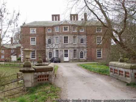
Boynton Hall Listed Grade I
The stone-built core of the present house is considered to have been the house built by William Strickland soon after he acquired the estate in 1549. Recent investigations suggest that this work maybe late medieval. The house was substantially enlarged c. 1590-1600 with addition of brick wings to the east and west.
Major alterations were made c. 1730 by Sir William Strickland with advice from Lord Burlington, when the house was ‘Palladianized’ with the addition of Venetian windows to the south and west fronts, and a Tuscan portico and gable with lunette window to the south front. A copy of the portico, which was later removed to the west front, has been reinstated recently on the south front. Finally in the 1760s-70s Sir George Strickland filled in the recessed area of the north front with an almost octagonal library designed by John Carr (Pevsner & Neave, Yorkshire, York and the East Riding, 334-5). The same architect also adapted and added to earlier buildings to create the pedimented service wing (Listed Grade II) attached to the south-east corner of the house.
Garden House Listed Grade II*
Possibly built as a banqueting house c. 1600. Brick with stone dressings, gothicized c. 1770 with the insertion of pointed windows and the addition of battlements. (Pevsner & Neave, Yorkshire, York and the East Riding, 336)
Dairy and Dovecote Listed Grade II
South-east of the hall is the Gothick dairy of c. 1770 with pointed arched arcade and a 17th or 18th century dovecote incorprating medieval stonework.
Lesser listed buildings in grounds
There are a number of other features that are listed grade II in the grounds in cluding the gatepiers of c. 1700 about 50 metres south-east of the hall and an 18th-century five-arched bridge about 85 metres west of the hall.
On the eastern edge of the grounds is the remnant of the woollen manufactory powered by a water mill established by Sir George Strickland around 1765 and commented on by Arthur Young. (Purdy, ‘Boynton’, 23) The listed circular dyehouse that stood nearby appears to have been recently demolished.
Carnaby Temple Listed Grade II
Carnaby Temple, a two-storey octagonal brick tower with lantern and basement, stands nearly ¾ m. south of Boynton Hall and ¾ m. north-west of Carnaby village. It was built c. 1772 probably to designs of John Carr as part of the landscaping of Boynton Hall (Lynch, ‘Taking great notice’, 7-9, 12-19) Shown on the 1775 edition of Jefferys’ plan but not on the 1772 edition.
Kitchen garden
There was a kitchen garden in the early 18th century, probably in the same position as the present later 18th-century walled garden to the east of Boynton Hall. A rectangular enclosed area is shown at this point on the plan of c. 1725, although it appears to be planted with trees, possibly fruit trees. It looks roughly divided into four squares divided by paths. A similar rectangular area, more clearly divided into four segments, is shown to the north of the Gypsey Race and south of the, then, road to Bridlington. This, no longer traceable on the ground, may have been an orchard.
The present walled garden surrounded by a high brick wall is still in use. Attached to a hothouse on the exterior wall at the south-east corner of the garden is a decorative arched arcade.
Park and plantations
Surviving parkland
The main area of surviving parkland, that is grassland with individual and clumps of trees, lies immediately to the north, east and south of Boynton Hall.
The Groves
An area of parkland, dotted with trees, to the south of Boynton Hall stretching as far as Woldgate, is marked as The Groves on 1888 Ordnance Survey map and up to the 1950s. It is not clear if this refers to the whole area of parkland immediately to the south of the Hall, but the term is used here in that context. It was an irregular area to the west and north of Fish Ponds Wood. It covered some 55-60 acres (22-24 ha).
The greater part of The Groves, some 33 acres (13.5 ha), was cleared of trees from the 1950s onwards and is now arable farmland. Only the parkland immediately south and south-west of the Hall remains. The Hollow Road is still a prominent feature.
West Lawn (76 acres/31 ha) and West Lawn Wood (29 acres/12 ha)
Another area of parkland is shown on the first edition Ordnance Survey map of 1850 to the west-north-west of the Hall, either side of the Gypsey Race and the route of the former road. This was an area of closes and, on the south side of the road, houses and their garths in the early 18th century. After emparking in the mid-late 18th century this area was presumably known as West Lawn, for the plantation that covers the northern part up to the present road from Rudston to Bridlington is known as West Lawn Wood.
About half of the former parkland is now arable farmland but the land south of the Gypsey Race is pasture, and the north-east segment towards the village retains a park-like character of permanent grassland with a spread of individual deciduous trees.
Fishponds Wood (42 acres/17 ha)
First planted in the late 18th or early 19th century Fishponds Wood covers much the same area as it did in the mid 19th century. It has been replanted on more than one occasion.
Hallowkiln Wood (31 acres/12.5 ha)
Hallowkiln Wood, an extension of the Boynton woodland, is in Carnaby parish on the south side of Wold Gate. It covers the same area that it did in the mid 19th century.
Sands Wood (90 acres/36.5 ha)
Sands Wood covers much the same area it did in the mid-19th century but has been replanted on a number of occasions and today consists of relatively young trees. This woodland where it adjoins Woldgate has figured in David Hockney’s paintings, drawings and films. The tree stump, known as the totem, which figured in these images was located here until cut down in 2012.
Books and articles
R. Alec-Smith, ‘Boynton Hall II’, Transactions of the Georgian Society for East Yorkshire, IV, i , 1955, 27-32.
K.J. Allison (ed), Victoria County History, Yorkshire, East Riding, II, 1974
C.V. Collier, An Account of the Boynton Family, 1914
T. Barringer and others, David Hockney: A Bigger Picture, 2012
W. Jardine, Memoirs of Hugh Edwin Strickland, 1858
F. Johnson, ‘Boynton Hall I’, Transactions of the Georgian Society for East Yorkshire, III, iii, 1954, 35-53
K. Lynch, ‘Taking great notice: Dorothy Richardson’s account of ornamental buildings on the Boynton Estate, East Riding of Yorkshire’, The Follies Journal 7 2007, 1-22
D. Neave & D. Turnbull, Landscaped Parks and Gardens of East Yorkshire 1992
A. Oswald, ‘Boynton Hall, Yorkshire’, Country Life 22 & 29 July 1954, 280-283, 356-359
J.D. Purdy, ‘Boynton’ in K.J. Allison (ed.), Victoria County History, East Riding of Yorkshire, II, 1974
S. Raikes & T. Knox, Nostell Priory and Parkland, 2001
A. Sinclair, ‘Sir William Strickland’s Hunting Lodge at Malton’, in J.F. Bold & E. Chaney (eds.) English Architecture Public and Private, 1993
H.E. Strickland, A General View of the Agriculture of the East Riding of Yorkshire, 1812
J.E. Strickland (ed.), Journal of a Tour in the United States of America 1794-95 by William Strickland, 1971
P. Willis, Charles Bridgeman and the English Landscape Garden, 2002
G. B. Wood, Historic Homes of Yorkshire, 1957
G. Worsley, ‘Boynton Hall, Yorkshire’, Country Life 19 Nov. 1992, 58-61.
Primary sources
Strickland Papers. The bulk of the archives of the Strickland family are in private hands in Canada. A detailed list of many of the records in Canada was made by Dr Adrian Green of Durham University in 2012-13.
Dorothy Richardson’s Journal 1802, John Rylands Library, University of Mancheter, English MS 1126. Quoted in Karen Lynch, ‘Taking great notice’ (above)
William Strickland’s naturalist’s diary. Private collection.
Maps
Map of Boynton c. 1725. In Strickland archive.
T. Jefferys, Yorkshire, published 1772 & 1775
H. Teesdale, Yorkshire, surveyed 1817-18, published 1828
A. Bryant , East Riding surveyed 1827-8, published 1829
Ordnance Survey maps published 1854 -2012.
")
, surveyed 1767-1770 & published in 1800. McMaster University Library, ref. RMC_4336 (CC BY-NC 2.5 CA)")


")