The historic designed landscape around Owston Hall was shaped by Bryan Cooke and his son, Philip Davies-Cooke, between 1785 and 1853. Bryan consulted the landscape designers Thomas White in 1785 and Humphry Repton in 1792, after making plans to build a new hall in the centre of his landholdings in Owston. These had been consolidated through enclosure and purchase since the Cooke family acquired the estate in 1698. While positioning the new hall there would have given him space to create a large park and gardens, he decided instead to put the building next to the existing hall to the east. Although this partly negated White’s and Repton’s proposals, some of their suggestions for improvement were adopted by Cooke over the next thirty years. These included a new kitchen garden, parkland, pleasure grounds, flower garden and extensive plantations.
Philip Davies-Cooke had plans to remodel the hall in the Grecian style on inheriting in 1821 but he too abandoned this project probably due to the cost. However he continued his father’s work in developing the grounds, adding four entrance lodges so that the hall could be accessed from five directions west to east. He turned the pleasure grounds around the hall into an arboretum, reflecting his scientific interest and planted a vineyard. With Philip’s death, his successors inherited the estate but also many debts, so there were neither the resources nor the will to continue expanding Owston’s designed landscape. The Davies-Cooke family concentrated on their estate in Wales instead.
When coal reserves were finally found on the estate in the early 1900s, it provided much needed revenue but the family invested the funds in their other estate. By the early 1930s, the hall had been converted to a golf club house with most of the parkland turned into a golf course. Large parts of the estate were sold off to cover death duties in 1946 and the remainder including the hall and former parkland were sold in 1979. Its new owner kept the golf course and turned the hall into a hotel, which remains to this day. Although much altered the mid-19th century designed landscape is still legible today as a setting for Owston Hall and its associated buildings.
Note for a full description of this site please see: Klemperer, M. 2010. Style and Social Competition in the Large Scale Ornamental Landscapes of the Doncaster District of South Yorkshire c. 1680-1840. Oxford, Archaeopress, 231-280 & 490-516.
Note all references are from the Davies-Cooke collection at Doncaster Archives (DA DD/DC) unless otherwise stated.
Estate owners
By the 13th century, the manor of Owston was in the hands of the de Veilli [Veilly] family. In 1284, Sir Humphrey de Veilli transferred it to Sir William de Hamilton (PRO 1902, 286). Henry de Lacy (Earl of Lincoln) took possession from Hamilton in 1292 (TNA DL 25/2133). De Lacy’s heir, Alice, married Thomas, 2nd Earl of Lancaster. With Lancaster’s execution in 1322, his estates were largely forfeited to the Crown, although his widow may have retained her marriage portion that included Owston. On her death in 1348, they went to her husband’s nephew, Henry, Duke of Lancaster. His daughter, Blanche, married John of Gaunt and when their son became Henry IV in 1399, Owston passed to the Crown as part of the estates of the Duchy of Lancaster.
The Adams family of nearby Burghwallis had leased some of the lands and in 1617, Philip Adams bought the manor from Sir William Wa[a]de (YAS 1917, 97), the latter having been granted it by James I on 22 June 1604 (A1/10/1). The Adams family held Owston until the late 17th century when it was sold to Henry Cooke. On the latter’s death in 1717, the estate passed to his son, Bryan. When the latter died without direct issue in 1754, it went to his brother, Anthony, and then to Anthony’s son, Bryan, in 1761. As Bryan was only five, the estate was managed by his mother for twenty years.
Philip Davies-Cooke was the new owner after his father’s death in 1821 and his son, Philip Bryan, in turn inherited in 1853, followed by his son, Philip Tatton, in 1903. The Davies-Cooke family continued to own Owston Hall until 1979 although parts of the estate had been sold off in 1946. The Hall and immediate grounds including the golf course are owned by the current hotel.
Key owners responsible for major developments of the designed landscape and dates of their involvement:
Philip Adams 1617 - 38?
Henry Cooke 1698 – 1717
Bryan Cooke c. 1723 - 1754
Anthony Cooke 1754 - 1761
Bryan Cooke c. 1785 – 1821
Philip Cooke (later Davies-Cooke) 1821 – 1853
Early history of the site
In the Domesday Book, the settlement of Owston had 3 carucates (c. 360 acres) of arable land, 8 acres of meadow and c. 2¼ square miles of woodland in 1086 (https://opendomesday.org/place/SE5511/owston/ consulted 13 November 2023). By the 13th century, the manor of Owston (Ouston) was owned by the de Veilli family. In 1284 ‘Humphrey de Veilli, son and heir of the late Sir Robert de Veilli, [transferred] to Sir William de Hamelton, clerk…his chief messuage and all his manor of Ouston’ (PRO 1902, 371-2). Eight years later, it was the property of Henry de Lacy, Earl of Lincoln and then his daughter and son-in-law. However with the latter’s death in 1322, it became part of the Duchy of Lancaster and ultimately belonged to the Crown.
When it was acquired by Philip Adams in 1617 (YAS 1917, 97), the estate was described as: ‘Manor of Owston and messuage, 6 cottages and lands in Owston, Burghwallis and Skellowe’. The Adams family were likely to have had a manor house or hall, probably on or near the current hall site but when it was built is uncertain. A survey of the lands of Sir William Adams during his minority (c. 1638 - 48) showed that he held c. 300 acres of land, renting over 100 acres from Godfrey Copley of Sprotborough (E3/1/1). The manor, lands and tithes of Owston were purchased by Henry Cooke (A1/10/7), with the manor rights being bought for £273 1s 3d from Dame Mary Adams (widow of Sir William) on 14 April 1698 (A1/10/6). In total the cost was £5,075 13s 1d with sale completed by 6 December 1698.
A map and survey of 1723 (E4/1/1 and E3/1/2) of ‘Owston fields’ showed they covered 329 acres and included three large open fields: Wood Field, Middle Field and Carcroft Field. Cooke owned just under 272 acres with the rest belonging to other freeholders. The hall was in the centre of the village opposite the church. Although there was no mention of garden areas in the survey nor shown on the map, the accounts refer to the employment of a gardener from 1717 and the repainting of the garden gates in 1719 (E11/1). The closes around the hall, such as Clover Close, were planted with trees in January 1720/1 (ibid). Later it was noted that elm and sycamore trees planted in hedgerows c. 1700 in the fields to the south of the hall now were in the parkland (E7/1).
The enclosure of Owston had started with Henry Cooke following his purchase of the estate, with a petition to the Lord Privy Seal c. 1700-5 (E1/1/1). However the final enclosure of Owston’s common land came with the Act of Parliament in 1761, with Anthony Cooke getting 57 acres out of the 226 acres available (E1/1/23). Cooke clearly had been keen to consolidate his estate as he had commissioned a survey in 1756 (E4/6/1) of land he did not own. The survey of 1768 (E3/1/3) showed that the Cooke family’s landowning in Owston was 949 acres but the area ‘in hand’ was just over 36 acres and included:
Court and Garden 3r 7p
Garden 1a 3r 1p
Paddock 4a 3r 35p
Long Close 5a 3r 26p
Hall Croft 6a 12p
Fold Stead 1r 14p
At this stage, there was also 14 acres of woodland including ‘Lady Wood’ and other areas to the southeast that were later incorporated into the East Park.
Anthony Cooke died in 1761 and his widow, Mary, looked after the estate during her son’s minority. She continued to acquire land and the survey map of 1780 (E3/8/2) depicted a more integrated pattern of landholding. The land in hand though had only increased slightly to 38½ acres with just a garden and paddocks around the hall. The layout of the estate by 1780 is shown in Figure 1.
Chronological history of the designed landscape
1785 – 1821
Bryan Cooke took control of his estate from his mother in 1785. There were already plans for a new house, with a scheme to extend the existing buildings by William Whitelock drawn up in 1783 (H1/3/1). Cooke though had grander ambitions and engaged William Lindley, previously assistant to John Carr. Lindley first visited in early 1785 and in a letter talked of placing the new building in a nearby field (H1/1/2). He then produced a series of plans between 1786 and 1794 (H1/3/5-13). At the same time, the landscape designer, Thomas White, was called in to provide an improvement plan (H1/3/2, copy in Turnbull and Wickham 2022, 223). White followed Lindley’s original position for a new house and created a parkland with shelterbelts in the surrounding fields. He also proposed a new kitchen garden to the northeast.
White was paid £44 15s for ‘Plan & Larch Trees’ on 24 November 1788 (H6/9) and then appeared to have no further involvement. Although his plan was not implemented in full, probably due to Cooke’s indecision re the location of the new hall, there are elements that did appear later. These included his location of the new kitchen garden and the landscaping around it, together with the shelterbelt at the southern end of Carcroft Field done in 1785 and 1788 respectively (E7/1). Further work including a plantation at the bottom of Wood Close in 1786, the ‘Garden plantation’ north of the kitchen garden and clumps in the park (ibid) are shown on the estate plan from 1788 (E4/1/3). The previous year, Cooke had gained permission for the diversion of the road immediately next to hall to east of the churchyard (WYASW QS1/127/7). The accompanying survey to the 1788 estate plan (E3/1/6) confirmed nearly 160 acres were now in hand out of a total of 1306 acres, including the old ‘Middle Field’. This demonstrated that Cooke was actively planning a new ornamental landscape.
While the kitchen garden was built in 1791 and the stables the following year (E7/1), Cooke did not implement more of White’s plan, perhaps wanting a simpler (and less expensive?) scheme. An undated and anonymous plan (E4/1/5), including the new mansion in the centre, may have been another proposal c. 1789-92, as it seems to be a simplified version of White’s plan. Cooke instead engaged Humphry Repton, who visited Owston on 28 August 1792 and walked the park with Cooke, offering his suggestions for improvement (Eyres and Lynch 2018, 32). In February of the following year, Repton completed his ‘Red Book’ for Owston (copy in Eyres and Lynch 2018, 35-47) and he was paid £59 17s for ‘his visits x 4, drawings, intended improvement at Owston’ (H6/4) on 3 July 1793. Repton’s sketch plan (Eyres and Lynch 2018, 38-9) has the new house placed in same position as White’s plan, with the existing planting marked in black and his proposals in green.
Both Repton’s and White’s plans though proved somewhat redundant as Cooke finally made the decision in 1793 to build the new hall just next to the old one. There is an undated plan (H1/3/4) that shows the new hall in its current position, with an area of open parkland surrounded by a shelterbelt of trees. These changes were implemented as they can be seen on the estate map of 1802 (E4/1/8). One suggestion in Repton’s original scheme for the long plantation between the park and Skellow Croft Gate was carried out in 1795 (E7/1).
Meanwhile Cooke continued to take land into his control with the 1793 survey, giving ‘land in hand’ of 391 acres (E3/1/8). This continued to grow and by the 1803 survey (E3/8/3), the land in hand was 416 acres and included:
Part of Far Park c. 18 acres
Garden 1a 2r 13p
Nursery 3r 15p
Orchard (south of garden) 2r 4p
Pleasure ground 2r 4p
Mansion House and Court Yard 1a 1r 15p
Stables, outbuildings etc 2a 1r 15p
Garden 34p
Hall Ing 18a 3r 35p
The Park with small plantations 75a 17p
Plantations at side of park 3a
The layout of the estate by 1803 is shown in Figure 2.
From 1804, the main focus was to add plantations in the increasing parkland, with quarry areas ‘ornamented’ presumably to hide their purpose (E7/1). In 1806 the shrubbery between the hall and kitchen garden was added and a sunk fence was put in front of the hall a year later (ibid). The first of what would be five entrance lodges, Owston Lodge, from the old road through the village, was built in 1811 (ibid). Further developments in 1818 included the planting of a row of limes east of the vineyard and a new flower garden north of the hall and the following year a vineyard was planted in the kitchen garden (ibid).
1822 – 1853
On Bryan Cooke’s death in 1821, his son Philip inherited. Through his mother, he also gained the estate of Gwysaney in Wales and added Davies to the family name. Philip wanted to remodel the hall in Grecian style but the cost of over £3,000 was prohibitive (H1/2/8). Instead in 1828, he built Doncaster Lodge in the Greek Gothic style (E7/1) having further diverted the public road just south of Owston village away from the hall and church the previous year (WYASW QS1/166/10). He continued to develop the designed landscape by planting an ‘English vineyard’ in 1823 (a ‘French’ one was added in 1830) to the east of the kitchen garden and in 1827, he started an arboretum in the pleasure grounds between the hall and the kitchen garden (E7/1). This had many exotic species including many newly introduced North American species such as Pinus sabiniana (1832) and Pinus ponderosa (1827) (E7/3). An undated plan (H1/3/22, Figure 3) but c. 1830 shows the layout of the grounds around the hall at this time with specific areas dedicated to individual species.
The areas of parkland continued to grow with the re-routing of main Doncaster road east (WYASW QS1/166/10) enabling the former Hall Ings to become part of Low Park (E4/1/9). The survey of 1828 (E3/8/4) had the following ‘in hand’:
Park without small plantation 91a 11p
Far Park without Lords plantation 7a 2r 13p
Far Park 7a 32p
Park including Carcroft Common 17a 1r 8p
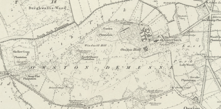
From 1829, Davies-Cooke continued to enhance the parkland adding a carriageway from Doncaster Lodge that year, avenues of trees and rides through the plantations (E7/1). As he built more lodges, Skellow (1832), Askern (1840) and Carcroft (1842), more carriageways and avenues were added (ibid). In 1833, a greenhouse was built attached to the house, later replaced by current one from Messenger & Co c. 1854 (ibid). It was perhaps designed to grow his extensive collection of 32 orange and lemon varieties (E7/3) and other exotic plants (E7/1). A map (E4/1/10) and survey (E3/1/9) from 1842 shows the largely completed designed landscape where the total ‘in hand’ including plantations was 593½ acres with the ‘Mansion, offices, courtyard, (kitchen) garden and pleasure grounds’ covering just over 32 acres and parkland of 153 acres. The 1st edition 6” OS map (Figure 4), surveyed in 1849, gives a detailed picture of Owston’s landscape at its height.
Later history
Davies-Cooke’s son, Philip Bryan, succeeded in 1853 but did little to the estate due to his father’s debts and floods in 1866. He let the estate from 1857 and moved permanently to Wales in 1881. While the grounds and kitchen garden were maintained, little was added with the exception of a gothic archway from the northeast side of the kitchen garden to the Garden Plantation. This reputedly came from the medieval chapel at nearby Thorpe-in-Balne that had collapsed in 1865. Another decorative arch similar to a ruined bridge was put in the pleasure grounds around the kitchen garden possibly at the same time.
The woodland continued to be managed with further planting of a range of tree species as before (E7/10). Another glasshouse and attached wall were added to the service area north of the kitchen garden, sometime before 1883 (E7/12). Philip Bryan had looked for other ways to get an income from Owston including mining but was unable to find coal reserves. His son, Philip Tatton, was more successful on inheriting in 1903 with mining starting in 1910. The estate though became surrounded by colliery housing but the income allowed debts to be paid. However any funds were used at the Wales estate and the hall was unoccupied between 1910 and 1914.
In 1914, the front part of the hall was let and in 1928, it became a golf club house with the golf course occupying 124 acres of parkland. Felling continued of the old ornamental trees with more standard timber trees replacing them. The estate was transferred to Philip Ralph, son of Philip Tatton, in 1929. A survey of that date showed a much reduced designed landscape (E3/8/21):
Plantations & woods 369a
NW Park 23a
North Park 28a
House & grounds 12.5a
Kitchen garden 2.6a
The revised 6” OS map from 1930 shows the impact of the changes to the landscape due to the colliery housing and the creation of the golf course on the parkland (Figure 5).
Philip Ralph’s father died in 1946 and death duties forced the sale of 1614 acres of land, with 980 acres remaining. The hall was converted to flats and the kitchen garden turned into a market garden. With Philip Ralph Davies-Cooke’s death in 1976, the remaining estate was sold in 1979 to Peter Edwards, who turned into a hotel. This was sold to the present owners in 2022.
Location
Owston lies 5 miles (8km) north of Doncaster.
Area
The historic designed landscape at its greatest extent in the mid-19th century covered 378 acres (153 ha).
Boundaries
The northern boundary was formed by the dividing line between the parishes of Owston and Burghwallis, starting at Stony Croft Lane in the west to the Selby-Doncaster road in the east and then the northern extent of Brick Kiln Plantation. The eastern boundary was the Holme Dike with the southern boundary starting there and following the southern extent of Brick Kiln Plantation to the public road and Owston Lodge. It then continues along the Skellow & Owston Lane to Skellow Lodge. The western boundary is formed by Stony Croft Lane until the parish dividing line.
Landform
The site of the hall and immediate grounds lies between 17m and 19m AOD. The parkland is undulating and ranges from 6m AOD in area south of the hall to 36m AOD at North Quarry Plantation. Owston’s underlying geology is Brotherton Formation (limestone sedimentary bedrock) in the parkland, Roxby Formation (mudstone bedrock) in the east around the A19 and Chester Formation (sandstone) in Brick Kiln Plantation. This is overlain with clay, silty superficial deposits. The eastern parkland has freely draining lime-rich loamy soils with moderate fertility and the rest of the estate has slowly permeable, seasonally wet, slightly acid loamy and clayey soils with moderate fertility.
Setting
Owston Hall park and garden mainly lies in Doncaster Council’s Local Characterisation Area of C3 – Carcroft to Norton Limestone Plateau. This area is defined by its slightly raised elevation and the magnesium limestone geological deposits. This is a strongly rural area in which farmland predominates with mainly arable fields. The hall and eastern part of the estate lies in a designated Conservation Area.
Entrances and approaches
Doncaster Lodge [Grade II – NHLE 1151468]
Built in 1828 to design by P. F. Robinson. The adjacent gates and gatepiers are probably contemporary and also listed (Grade II – NHLE 1192283). It gave access from the east and the main Doncaster to Selby road, through the East Park to the southern entrance of the hall.
Owston Lodge
Built in 1811 on old village road to the southeast of the hall, the carriageway went due north until it met the route in from Doncaster Lodge.
Carcroft Lodge
Built in 1842, it was the last to be constructed and gave access from the southwest off the Skellow and Owston Lane. The carriageway joined that of the one from Skellow Lodge in the middle of the park.
Skellow Lodge
Built in 1832 to provide an entrance from the west and Skellow village, it was demolished in the second half of the 20th century. Its carriageway went through Stony Flat Plantation before going southeast into the park and then onto the southern entrance of the hall.
Askern Lodge
Built in 1840, it gave a northeast access to the estate from main Doncaster to Selby road. The former public road leading from it was principally to the church, stables and other service buildings.
Principal buildings
Owston Hall [Grade II* - NHLE 1286676]
Main part built 1794-5 by William Lindley with possible parts of earlier building incorporated into it. A conservatory by Messenger & Co. originally built c. 1854 is attached.
Stables [Grade II – NHLE 1151470]
Constructed in 1792 to the north of the hall.
Church of All Saints [Grade I – NHLE 1192336]
Dating back to the 11th century, parts were restored in 1872-3 by Sir George Gilbert Scott.
Gardens and pleasure grounds
To the south of the original hall was a small garden area of just under an acre that is shown with trees on the 1768 map (E4/1/3). To the west was an area of nearly five acres that is described as a paddock (ibid) and to the east across the road was another area of pasture called ‘Hall Croft’ (or ‘Hall Ings’) of 6 acres (Figure 1). When the new kitchen garden was placed to the north in the former ‘Long Close’, the area between it and the new hall became the focus for the pleasure grounds. With the diversion of the public road, the Hall Ings with its ponds was also landscaped (Figure 2).
Arboretum
This was developed from 1827 in the pleasure grounds south of the kitchen garden and south and east of the hall in the former Hall Ings. Species that were planted included (E7/3):
|
Common Name |
Latin name |
Location |
|
Athenian poplar |
Populus nigra subsp. caudina? |
Fishpond Close |
|
Black Italian poplar |
Populus x canadensis ‘Serotina’ |
Fishpond Close |
|
Poplar leaved birch |
Betula populifolia |
Fishpond Close |
|
Chinese ash |
Fraxinus chinensis |
Fishpond Close |
|
Snowy Mespilus |
Amelanchier lamarckii |
Paddock by churchyard |
|
Early Mespilus |
Mespilus germanica ? |
Paddock by churchyard |
|
Cut leaved alder |
Alnus glutinosa ‘Imperialis’ |
Fishpond Close |
|
Manna ash |
Fraxinus ornus |
Fishpond Close |
|
Lombardy popular |
Populus nigra |
Fishpond Close |
|
Silver fir |
Abies alba |
Pleasure ground between garden and brewhouse |
|
White American spruce fir |
Picea glauca |
Pleasure ground between garden and brewhouse |
|
Parsley leaved elder |
Sambucus nigra f. laciniata |
Paddock by churchyard |
|
Snowdrop tree |
Halesia carolina |
Paddock by churchyard |
|
Bondue tree |
Gymnocladus dioicus |
Paddock by churchyard |
|
Tamarisk germain |
Tamarix ? |
Paddock by churchyard |
|
Tamarisk French |
Tamarix gallica |
By brewhouse |
|
Three thorned acacia |
Senegalia senegal |
Paddock by churchyard |
The species were grouped in areas in the pleasure grounds and are noted on a plan of c. 1830 (H1/3/22, Figure 3).
Flower Garden
Located next to the south of the kitchen garden (Figure 3), it was started in 1818. The planting here also reflected Davies-Cooke’s interest in unusual species such as striped blackcurrants (Ribes nigrum?) and blood coloured bladder senna (Colutea orientalis) (E7/3).
Kitchen garden
The first kitchen garden was located adjacent to the hall and in 1768, it covered just under 2 acres (E3/1/3, Figure 1). Whether this is the one referred to in accounts from 1719 (E11/1) is not clear as the area due south of the hall is also called a garden with trees shown (possibly an orchard) in the 1768 survey. With the remodelling of the landscape, a new walled kitchen garden was built in 1791 approximately in the position indicated by White at the northern end of Long Close. The walls remain and are listed Grade II (NHLE 1314851). A survey from 1803 (E3/8/3) gave its extent at 1a 2r 13p, which was just the area within the walls. To the north was added a service area that measured an acre.
There is a reference to work being done by a mason on the ‘Peach House’ (E11/12) between 1807 and 1813. This may have been the freestanding building shown outside the northern wall on the 1830s plan (Figure 3). By the 1840s there was a range of glasshouses on the northern wall and a freestanding one inside. On the west section of the north wall were two furnace sheds providing heat for the adjacent walls and on the east section were the bothies or service buildings (Figure 4). By 1883, another wall had been built in the northern section with an attached glasshouse, together with a fernery on the northern side of the north wall (CS Archaeology 2011, 9). An inventory of that year (E7/12) listed the following ‘Garden Buildings’: Stove House, Vinery No 1, Vinery No 2, Orangery, Conservatory, Fernery, Peach House and Frames. No details are given of location but Figure 7 indicates where they may have been. Another glasshouse was added to the wall just north of the peach house by the tenant, W. H. Matthews, in 1908 (MERL TRMES AD1/1916) and an extension was put to the southern side of the possible orangery before 1930.
Park and plantations
The Park
Covering the southern half of the estate, this was started in the 1790s and by 1802 covered 75 acres (E3/8/3, Figure 2). By 1828, this had expanded to 91 acres (E3/8/4) and by 1842, it had reached its greatest extent at 140 acres excluding plantations.
North Park
Originally known as ‘Far Park’, in 1803 it covered just 8 acres in the northern section (the other 10 acres) would be added to ‘The Park’. By 1842, it had expanded to 28½ acres (E3/1/9) and just over 49 acres by 1849 (Figure 6).
East Park
This was the last parkland to be developed after the construction of the carriageway from Doncaster Lodge in 1829. It covered 34 acres excluding plantations (Figure 6).
Garden Plantation
This was the first plantation put in to the west of the area that would become the kitchen garden. Planted from 1785, it covered 8 acres.
North Quarry Plantation
Started in the late 1780s, it covered just under 5½ acres.
North Park Plantation
Part in place by 1802 (following Repton’s suggestion?), it had been removed by the 1890s.
Skellow Cross Plantation
Put in c. 1832-8 after the building of Skellow Lodge, it covered just under 9 acres.
Stony Flat Plantation
South of Skellow Cross Plantation, part was in place by 1795 (following Repton’s suggestion, E7/1) and was 6 acres in extent.
Lady Wood
This is the oldest area of trees being mentioned in the 1768 survey and was situated next to other areas of woodland. In 1805, it was replanted or added to (E7/1)? With the move of the public road east, it became part of East Park in the 1830s and was an area of c. 2 acres.
Wood Close Plantation
Next to Lady Wood, this was started in1786 (E7/1) and covered just under 2.5 acres.
Stockbridge Plantation
The southern section (4 acres) planted in 1807 (E7/1) with the northern section (2¼ acres) by 1842.
Brickkiln Plantation
Originally called ‘Whin Coverts’, this slightly detached part of the designed landscape was planted initially between 1790 and 1794 (E7/1) with further planting in 1820 & 1822 and covered 33 acres.
Water
The small pond in the East Park was in the area called ‘Hall Croft’ or ‘Hall Ing’ and is shown on an undated plan (E4/1/7) thought to be from the 1770s. Repton had included it in his design to make a larger serpentine piece of water (Eyres and Lynch 2018,38-9). This was not adopted, instead the existing ‘Southern Fishpond’ was ornamented with trees and shrubs (H1/3/22).
Books and articles
CS Archaeology 2011. The Walled Garden, Owston Hall Hotel, Doncaster, South Yorkshire: An Archaeological Building Record. Unpublished report, copy available online at https://doi.org/10.5284/1019204
Eyres, P. and Lynch, K. 2018. On the Spot: The Yorkshire Red Books of Humphry Repton, Landscape Gardener. Leeds, New Arcadian Press.
PRO 1902. Calendar of Close Rolls, Edward I, 1279-88. London, HMSO.
Turnbull, D. and Wickham, L. 2022. Thomas White (c. 1736-1811): Redesigning the northern British landscape. Oxford, Windgather Press.
YAS 1917. Yorkshire fines for the Stuart period, Vol. 2 (Record Series Volume 58). Leeds, Yorkshire Archaeological Society.
Primary sources
Doncaster Archives (DA)
Records of Davies-Cooke family of Owston (DD/DC)A1/10/1 Defeasance of Manor of Owston to Philip Adams of Owston from Sir William Waad of Battleshall, Essex, 13 July 1617
A1/10/6 Conveyance of Manor of Owston from Dame Mary Adams, widow, of York to Henry Cooke, 14 April 1698
A1/10/7 Account of monies paid by Henry Cooke to John Adams and Lady Adams for the purchase of the Manor, Lands and Tithes of Owston, May 1697-November 1698
E1/1/1 Copies of Petition of Henry Cooke to Sir Nathan Wright, Lord Privy Seal, relating to Owston Waste, c. 1700-5
E1/1/23 Enclosure Award, 7 September 1761
E3/1/1 Copy of an old Ext(ent) of the Lands in Owston in the minority of Sir Wm. Adams, 18th century
E3/1/2 Survey book of Owston Fields, 1723
E3/1/3 Survey book of the Lordship of Owston near Doncaster belonging to the Representative of Anthony Cooke, Esq., surveyed by John Flintoff, 1768
E3/1/6 Survey of Owston and Tilts with account of the farms, Candlemas 1788
E3/1/8 Survey of lands belonging to Col. Bryan Cooke in Owston, Carcroft and Skellow, Tilts, Thorpe, Waite House and Bentley, 1780 (incl plan)
E3/1/9 Survey of Owston estate, 1842
E3/8/2 Survey of lands belonging to Col. Bryan Cooke in Owston, Carcroft and Skellow, Tilts, Thorpe, Waite House and Bentley, 1780 (incl plan)
E3/8/3 Survey of the Manor of Owston containing the Particulars of the several farms belonging to Bryan Cooke Esq., and other lands (in Owston, Carcroft Holme and Tilts) by J. Colbeck., 1803
E3/8/4 List of tenants, giving names, premises, acreages and values of lands at Owston, Thorpe, etc including land occupied by Cooke, 1828
E3/8/21 Schedules of lands in Owston, Skellow and Thorpe belonging to P. T. Davies Cooke, 1930?
E4/1/1 A map of Owston Field, 1723
E4/1/3 Sketch of lands in Owston and Tilts, 1788
E4/1/5 Plan of Fields in Owston marking site of the new garden, late 18th century
E4/1/7 Plan of lands in Owston, late 18th century
E4/1/8 A Map of the Manor of Owston by Joseph Colbeck, 1802
E4/1/9 A Map of the Manor of Owston copied for Philip Davies Cooke Esq., from the original of Colbeck (1802), 1827
E4/1/10 Plan of the Manor of Owston and adjoining lands in Owston belonging to P.B. Davies Cooke, 1842
E4/6/1 Plan of land in Owston Fields, Skellow and Carcroft belonging to Anthony Cooke, Esq surveyed by Joseph Colbeck, 1756
E7/1 Memoranda of trees planted and houses built on the Owston Estate and other developments regarding plantations, 1785-1848
E7/3 An account of Forest Trees, Deciduous Flowering and Evergreen Shrubs and Bog Plants, their names and where planted, c. 1815
E7/10 Measurement of Hedges Log Book, 1880-1910
E7/12 Rough Notebooks on planting of trees, 1884-8
E11/1 Copy Accounts of Thomas Herrot, Steward to Bryan Cooke of Owston Hall, 1716-29
E11/2 General Account Book, 1743-7
E11/12 Abstracted Account book, 1807-13
H1/1/2 Letters of William Lindley, architect, at Doncaster to Bryan Cooke, 1785-7
H1/2/8 Estimates of Making the proposed additions to the present House, late 18th century
H1/3/1 Part of a New Design for Owston showing existing buildings and proposed additions by (W.) Whitelock, 1783
H1/3/2 Improvement plan by Thomas White, 1785
H1/3/4 Site plan of house and stables with environs with sketch of trees (to be planted?), c. 1794
H1/3/5-13 Plans by W. Lindley for new house, 1794
H1/3/22 Plan of shrubberies and surrounding gardens, c. 1830
H6/4 General Account Book of Bryan Cooke of cash receipts and disbursements, March 1794 to February 1799
H6/9 General Household Account Book, December 1783 to February 1794
The Museum of English Rural Life (MERL)
TRMES AD1/1916 Messenger & Co: Glasshouse for Owston Hall, W.H. Matthews [Tenant] per D.P. Davies Cooke [Landlord], 1908
The National Archives (TNA)
DL 25/2133 Appointment by Henry de Lascy, Earl of Lincoln, of attorneys to receive seisin of the manor of Owston, 26 October 1292
West Yorkshire Archives Service Wakefield (WYASW)
QS1/127/7 Diversion of road at Owston, July 1788
QS1/166/10 Diversion of road at Owston, October 1827
Maps
Ordnance Survey 6” 1st edition, surveyed 1849, published 1854
Ordnance Survey 25” revised edition, surveyed 1904, published 1906
Ordnance Survey 6” revised edition, published 1930
Figure 1 – Landscape c. 1780. Drawing by Michael Klemperer.
Figure 2 – Landscape c. 1802. Drawing by Michael Klemperer
Figure 3 – Sketch of grounds around hall c. 1830 redrawn from H1/3/22
Figure 4 – Layout of Owston estate on Ordnance Survey 6” 1st edition, surveyed 1849, published 1854. National Library of Scotland. CC-BY
Figure 5 – Layout of Owston estate on Ordnance Survey 6” revised edition, published 1930. National Library of Scotland. CC-BY
Figure 6 – Landscape mid-19th century. Drawing by Michael Klemperer.
Figure 7 – Layout of kitchen garden by 1883 with possible location of glasshouses. Ordnance Survey 25” revised edition, surveyed 1904, published 1906. National Library of Scotland. CC-BY


