The designed landscape developed alongside the building of a new Bishop’s Palace in Ripon in the 1830s is largely the work of Charles Thomas Longley, Bishop of Ripon from 1836 to 1856. Subsequent bishops of Ripon occupied the Palace and grounds until the 1940s, when the estate was made over to Barnardo’s Homes. Around the new residence for the bishops an area of parkland was laid out, as well shelter belts and pleasure gardens and a walled kitchen garden was developed.
Estate owners
The site of the future Bishop’s residence, situated in the Township of North Stainley, originally formed part of the Liberty of Ripon, under the direct jurisdiction of the Archbishop of York. However, the Ecclesiastical Commissioners Act of 1836 entrusted all business relating to the sale, purchase, or management of church lands to the Commissioners and the site remained in their possession until 1946. In 1940 Bishop Lunt, the last Bishop to occupy the residence, handed it over temporarily to serve as an evacuation centre for girls to Barnardo’s Homes, before it was sold to them in 1946. Ownership has further diversified in the latter part of the 20th century. The main portion of the site is occupied by a residential school and the former walled garden is now run by Ripon Community Link.
Key occupiers responsible for major developments of the historic designed landscape and their dates of involvement:
Charles Thomas Longley, 1st Bishop of Ripon 1836-56
William Boyd Carpenter, Bishop of Ripon 1884-1911
Early history of the site
In 1836, the decision was taken to establish the modern See of Ripon and to nominate the then headmaster of Harrow, Charles Thomas Longley, as the first bishop. The following year, Bishop Longley was empowered to seek out a suitable site for building ‘a House of Residence for the Bishops of Ripon and of allotting to it an appropriate demesne’ (WYAS LDR 2656, 13). Negotiations with Mrs Sophia Lawrence of Studley Royal had led to the acquisition of the leasehold of a farm, situated to the north of Ripon, called Bramley Grange Farm together with the buildings and land amounting to 109 acres 1 rood and 26 perches (Figure 1, WYASW WYL 150/5548). The passing of the Order in Council for the sale of Bramley Grange Farm was reported in the Morning Post for 6 January 1838 and the sale registered in Wakefield later that month (WYASW MY 451-432). In January 1839, Mrs Lawrence made over the lease of the adjacent Day House Farm to the See of Ripon.
The site having been selected, plans were submitted to the Commissioners by William Railton, Anthony Salvin and James Clephane, the latter then working at Wrest Park. After several adjustments to bring the costs down, Railton’s plans were eventually selected and a budget not exceeding £10,000 agreed. The drawings and estimates allowed for the erection of the palace, offices, brewhouse, stables, coach house, a stone terrace, kitchen garden wall, gardener’s house, farm buildings with well, lodge, gate piers and walls and a gate.
The stone for the buildings was given by Mrs Lawrence from her quarry at Hackfall and the builder was John Willoughby of York. The foundation stone for the residence was laid by Bishop Longley on 11 October 1838. The bishop and his family moved into the completed house in September 1841.
Chronological history of the designed landscape
1838 - 1856
The memorial of the sale agreement for Bramley Grange Farm (WYAS MY 451-432) was accompanied by a plan of part of Bramley Grange Farm as held by Mrs Lawrence under lease from the Archbishop of York, corresponding to the land allocated to the ecclesiastical residence (Figure 2). This located the original cluster of farm buildings roughly in the centre of the 109-acre holding and was accessed by a carriageway running east to west from the road from Ripon to West Tanfield. The farm buildings included a house and barn as well as four small detached structures nearby. The field containing the farm buildings also had a garth and orchard. The adjacent field listed a second orchard. In the field north of the buildings an annotation indicated the ‘Probable site of the Episcopal Residence’ (ibid).
The indenture of 8th August 1838 between the architect, Railton, and the builder, Willoughby, stated that
‘the said farmhouse and premises are conveniently situate[d] for offices and other buildings for working or storage’ (WYAS LDR 2855).
Railton had agreed with Mrs Lawrence the purchase of these buildings and that any alterations to the farmhouse or buildings were to be funded by Willoughby (ibid). However, the palace was eventually erected on the footprint of the farmstead and not as originally suggested, thereby making it necessary to clear the site and demolish the various buildings.
In correspondence with the Ecclesiastical Commission in June 1840 justifying the request for an additional grant of £2,400 for the completion of the palace and outbuildings, Railton stated that
‘the house was built in a plain open field; with neither fences nor roads, nor any of the usual appendages to a house’ (ibid).
The latter still to be built were the lodge, stone piers to the entrance gates and adjoining walls, the gardener’s house, various carriage roads and the drainage. The letter added that additional expense relating to the farm buildings was caused by their removal to a more convenient location near the garden. The request for additional funds was granted and the final total cost eventually reached £14,724. The generosity of the Ecclesiastical Commissioners and the grandeur of the new episcopal palaces did not pass unnoticed by the press. The Examiner loudly condemned the ‘extravagant demands of the Bishops’ in the case of the Ripon and Riseholme Palaces (25 November 1848).
From the start Bishop Longley took an active part in the general landscaping, together with the designing and planning of the pleasure grounds and kitchen garden. The walled kitchen garden, measuring just over an acre, was laid out on the footprint of the existing enclosure on the northern boundary. However in January 1839, its east wall was blown down onto its foundations owing to a violent storm, which affected much of the north of England and caused considerable damage to woodlands and parklands (York Herald, 12 January 1839). Despite this setback, the east wall was rebuilt.
Bishop Longley himself spent some £1,200 on the costs of the work. This included draining, double trenching, planting, fencing and forming the kitchen garden together with stocking the garden with fruit trees and shrubs and providing two glasshouses, laying out the pleasure grounds and the flower garden. For the work on the pleasure grounds and lawns surrounding the residence, the landscape gardener, William Pontey of Kirkheaton, was engaged. He was also charged with creating plantations of forest trees to form shelter belts, principally to the west of the property running up to the boundary of the walled garden as well as a discontinuous shelter belt on the southern boundary and along the A6108. The bishop’s memoirs add that most of the forest trees, including a single oak tree opposite his study window, were planted by the bishop himself who, for the first six years, pruned them with his own hand every spring (WYAS LDR 2656, 21).
In 1846, the Archbishop of York offered to pay for the erection of a larger chapel by the east front of the Palace to replace the small, internal private chapel and provide a place of worship for local residents. After the ceremonial laying of the foundation stone the Leeds Intelligencer reports that
‘nearly 150 of the principal gentry present partook of a cold collation […] and spent the afternoon in perambulating the gardens of the Palace’ (July 4 1846).
Owing to the natural geology, drainage of the site and palace was a recurrent problem. In 1850, the bishop obtained a loan of £150 from the Treasury to be spent on draining. The memoirs noted that it was used in the winter of 1850-51 for draining
‘the North Field which slopes towards the kitchen garden and walk leading to it; as well as to the Paddock thro’ which the Back Road passes […] At the same time an attempt was made to drain the South Field of 14 acres below the Lawn’ (ibid, 31).
The South Field was the open grassland formerly known as Pasture Bottoms and the North Field surrounded the walled garden and its adjacent paddock. Further funds were obtained for drainage in 1858 for the residence itself. A note on a plan of the drainage referred to the intention of
‘providing a remedy for the two existing evils viz. the damp state of the building and the noxious stench arising from the drainage’ (LPA ECE/11/1/1404).
The plan suggested pipe drains be installed to extend out to ‘the lawn’ on the west side of the house.
The 1st edition 6” OS map, surveyed between 1849 and 1853, showed the changes in the landscape following the building of the palace (Figure 3). The previous internal field boundaries had been removed with the designed landscape now extending to some 70 acres. The new walled kitchen garden and its adjacent orchard were linked by a tree-lined avenue or path, later known as the Bishop’s Walk, to the pleasure grounds surrounding the house. Around the parkland were shelter belts and inside it there were trees and clumps together with a new carriageway from the lodge. The pleasure grounds surrounding the house to the west were divided into 3 sections by means of paths and formal planting. To the south the pleasure grounds were more open and in the southwestern corner was a spring.
New features included an entrance lodge on the A6108, with the carriage drive leading across the open grounds to the entrance of the residence. On the northern boundary there was a gardener’s cottage next to the walled garden and orchard. South of the boundary of the orchard, an unidentified circular feature was shown, possibly a pond.
A broad shelter belt, with a sinuous boundary, lay to the north and west of the residence. A number of paths ran through the woodland leading towards a summerhouse at the southern tip. A less substantial area of boundary planting was shown to the south and east. Internally, the open area of parkland contained six clumps of trees and a number of single trees. The drives passed through two enclosed areas of woodland one to the north and one to the east of the Palace to reach the coach house and residence.
1856 - 1940
No documentary or map evidence appears to survive demonstrating major involvement by the successors of Bishop Longley in altering the pleasure gardens or landscaping features of the Bishop’s Palace. The memoirs, however, conclude with what is described as ‘a rough plan and list of Memorial Trees planted in the garden’ likely to have been added by Bishop William Boyd Carpenter, Bishop of Ripon from 1884-1911 (ibid, 159). This lists six royals who, on the occasion of their visits, between March 1895 and July 1910, planted trees in the grounds. Bishop Longley’s contribution is also mentioned, but with no date for the planting. The accompanying plan and any contemporary identifying plaques have been been lost. A reference to this planting is provided by a letter written to Bishop Boyd-Carpenter by Empress Victoria of Germany whose name figures on this list. She was the eldest daughter of Queen Victoria and a keen amateur gardener and the letter concluded with the annotation ‘I hope my tree is alive and growing’ (Major 1925, 255).
By the end of the century, the 25” OS map (Figure 4) showed that the palace buildings had been substantially extended on the west side over the whole length of the building and at the southern end facing the pleasure gardens. The latter now had a simplified internal layout comprising two main areas and a notable reduction in the number of trees and shrubs depicted. The summerhouse had been removed as it was no longer depicted in the western shelter belt. In the parkland, there had been a reduction in single trees and clumps from the early 1850s. A new enclosure measuring just over 1 acre was now located within the paddock east of the walled garden.
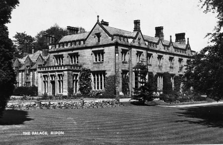
A photograph from the early 1930s illustrates some of the landscaping around the house. The house, seen from the southwest, has with a terrace running alongside the building and leading to a path extending into the pleasure gardens. Two flights of steps give access to the lawns below the terrace, between them a narrow bed is planted with shrubs. The path into the pleasure garden is lined with flower beds, edged by three short square pillars surmounted by stone balls. In a later photograph a flower bed between the two flights of steps survives but the lower bed has been grassed over (https://www.riponreviewed.org/image/705/bishops_palace, accessed 15/02/2023, Figure 5).
Later history
On 11 April 1940 the Ripon Gazette reported that the Bishop of Ripon was about to move from the palace to a smaller country house in a more accessible location at High Berrys on the outskirts of Ripon. The palace itself was temporarily leased to Barnardo’s Homes to serve as a girl’s residential school for 80 girls. In 1946 the Palace and grounds, minus 30 acres of farmland, were sold to Barnardo’s by the Ecclesiastical Commissioners. The girls’ school closed in 1947 and was succeeded by Spring Hill Residential Special School which opened in the Palace in 1951.
A number of buildings were erected in the open parkland to the east of the palace between 1950 and 1990. In 1962 and 1964 respectively, the lodge and the gardener’s house were sold whilst the palace buildings and half the grounds lying on the west were sold to developers. Three new houses were built in 1997 to the south between the coach house and the rear of the orchard. the Palace, Chapel and coach house were converted to private housing.
In 1950 Mr Morrison was appointed gardener by the school to look after all the grounds and lawns of the palace, the walled garden, orchard, and outbuildings with the help of one garden boy. After he retired in the mid-1980s he was not replaced and the walled garden and orchard fell into disuse., Barnardo’s Community Link project was launched in 1990 and restored the walled garden to provide horticultural activities for adults with learning difficulties. From 1990 to 2000, Spring Hill School ran training courses for senior students. When these ceased, the Walled Garden charity was taken over by Ripon Community Link.
Location
The bishop’s palace is situated approximately 1 mile to the northwest of the city of Ripon on the a6108.
Area
The historic designed landscape at its greatest extent comprises approximately 80 acres (32 hectares).
Boundaries
The eastern boundary is formed by the A6108 running north past the main entrance and the former porter’s lodge. It then follows the line of the drive leading to the walled garden and former gardener’s cottage. Beyond these buildings the boundary continues west following the shelter belt. Where it meets the open farmland, the boundary turns south following the shelter belt and field boundary. It then turns eastward for about 500m, runs southwards following the field boundary for about 900m before resuming a north eastern course eventually following the former parliamentary municipal boundary and re-joining the A6108.
Landform
The underlying bedrock geology of is composed of magnesian limestone of the Permian Brotherton formation capped with glacial deposits. This yields soils which are slightly acid, loamy, and clayey with impeded drainage. The fertility is moderate to high and is favourable to both arable and grassland cultivation.
Setting
The bishop’s palace estate is situated between the two floodplains of the River Ure and the River Laver approximately 1 mile from the city of Ripon. It is surrounded by predominantly flat intensively farmed arable farmland with a general absence of hedgerows and sparse tree cover. It is described in the North Yorkshire Landscape Character Assessment (2011) under Landscape Classification 25: Settled Vale Farmland. The land is flat or slightly undulating, generally below 40m AOD with the palace at 63m AOD.
Entrances and approaches
Gate piers and flanking walls at the entrance to Spring Hill school (Grade II, NHLE 1150618)
Limestone and ashlar gate piers and walls stand at the entrance to the former main approach to the bishop’s palace on the A6108, about 2m from the lodge (SE 306 570).
Gate piers and flanking walls at the entrance to the bishop’s palace and residential properties
To the north of the main entrance off the A6108, this was previously the main entrance to Bramley Grange farm before the construction of the bishop’s palace. It subsequently became a service entrance leading to the stables and coach house. The entrance is marked by two curved walls of coursed rubble limestone about 1m high with matching gate piers at each end. The two end piers are about 2m high and those flanking the driveway about 3m high. They are rectangular in shape and capped by pyramidal pier caps topped with a stone ball. Again, there is no evidence of any existing or former gate fittings.
Gate piers and wall enclosing stables and coach-house complex (Grade II, NHLE 13115273)
At SE 301 730 a coursed limestone wall, approximately 2.5m high with ridged coping encloses the courtyard formed by the former stables, service buildings and coach house ranges. Square gate piers with stepped pyramidal caps frame the modern double wooden gate.
Carriageway
At SE 305 730 a driveway leads from the A6108 to the main entrance of the former palace. This dates from c. 1841. Just within the gateway beyond the lodge, there is a wooden fence on both sides and further on the right-hand side there are young deciduous trees and one large oak. There are more mature trees on the left-hand side.
Carriageway
The second driveway along the A6108 at SE 303 732, dating from c. 1841, follows the course of the former access to the farm that originally stood on the site. It is now the entrance leading to private residences on the north and west sides of the drive and to the converted buildings of the bishop’s palace. The drive is lined with a tall hedge of conifers on the south side (approx. 3m high) and some deciduous trees on the north and west. The drive leads to the former service yard of the palace.
Carriageway and garden entrance from A6108
At SE 303 703 access to the walled garden and gardener’s cottage is provided by a wide unmade track. The driveway, which does not appear on historical maps, would appear to postdate the sale of the gardener’s cottage (now known as farm cottage) in 1964.
Principal buildings
Bishop’s palace (Grade II, NHLE 125968, listed as Spring Hill school)
The former episcopal palace was designed by William Railton in the Tudor style. The foundation stone was laid on 1 October 1838 (The Standard, 11 October) and the building completed in 1841. It consists of a two-storey ashlar building with a Welsh slate roof and a recessed service block. A covered passage with a doorway in the north side links the service block to the detached chapel, built in high gothic style. The chapel, the gift of the archbishop of York, was completed in 1846.
Stables and coach house ranges (Grade II, NHLE 1315273)
At se 301 730 there are the stables and coach house to the former palace dating from c. 1841. The buildings are disposed on 3 sides of a courtyard closed by a wall and double gates.
The Lodge (Grade II, NHLE 1295938)
The lodge at SE 305 730, is contemporaneous with the building of the palace c. 1841. It is a two-storey gabled cottage of coursed, squared limestone with ashlar dressings and a gabled porch.
Summerhouse
There is map evidence only for a small structure placed at the southern end of the broad shelter belt on the west boundary of the estate. It is present on the 1st edition 6” OS map, surveyed 1849 to 1853, but no documentary evidence or further map evidence survive.
Gardener’s cottage or farm cottage
Situated next to the walled garden on the northern boundary of the estate, it was built c. 1841. It was occupied by succession of gardeners, often with a younger undergardener as lodger. There is documentary evidence that this building, whether in its present form or as a rebuild, was relocated from the central position on the site occupied by the Bramley Farm farmstead. Originally the cottage was accessed from within the grounds but a new access on the northern boundary has been created.
Gardens and pleasure grounds
The pleasure grounds extended below a terrace to the south of the palace and to the west. Walbran’s Guide to Ripon, Fountains Abbey and several places of interest in their vicinity (1851, 51 Figure 6) contained an illustration of the east and south elevations of the palace. Today, the area below the terrace consists of an open grassed area surrounded by mature trees. To the west of the palace, there is a paved area with some ornamental planting below which lies a lawn with a scattering of mature trees on the periphery.
Kitchen garden
The kitchen garden is on the northern boundary and covers just under 1 acre (approximately 74m x 54m). The north wall is c. 4 m high and constructed of handmade 9”x3” bricks on the inside and outside face to the west of the entrance gate, whereas to the east the wall is faced with stone externally and brick internally. The copings are of stone throughout. A new gateway in the north wall has been formed with a with modern wooden gates, possibly in the early 1950s when the site was taken over by Spring Hill school.
The west wall, entirely brick built, has a doorway with a wooden door at the north end giving access from the adjacent gardener’s cottage. The south wall has stone on the north face and brick on the south face. The original entrance, marked by a doorway leading from the orchard to the walled garden remains in the centre of the south wall. The east wall is lower than those on the north and south sides, (c. 3m high) and is entirely constructed of brick with stone copings. The exterior face has 11 stepped brick buttresses along its length, perhaps to strengthen the wall when it was rebuilt after a severe storm blew down the original wall in 1839. Fruit trees, notably pears, were grown between the buttresses up into the 1970s, four of which survive.
Internally, it was subdivided into two main areas by a central path and perimeter paths giving access to the planting against the walls (Figures 3 & 4). Some residual traces of whitewashing on the inside of the north wall suggest this was the location of greenhouses as two small hothouses were listed amongst the expenses incurred by Bishop Longley. Within the garden there is some evidence of old wiring to support climbing trees and plants. A former headmaster recalled that when he arrived in 1971, the walled garden still had espalier fruit trees on the west and east sides of the east wall, the boilers that heated the original vinery were still in place and were brought back into use and the garden was divided into two plots providing the school with basic vegetables (R. Searle 7/2/2016 pers. com.). Another former teacher (1973-1990) recalled how the head gardener, Mr Morrison, kept the gardens in very good order. He planted two Tower of Glamis apples in the orchard and also maintained specimens of mirabelle plums, a brown turkey fig tree and espalier trained pears and plums. A large number of apple varieties, cookers and apples were also grown. After Mr Morrison retired in the mid-1980s, he was not replaced, and the walled garden fell into disuse (L. Williams 5/1/16, pers. com.). Today, under the aegis of Ripon Community Link, the walled garden and associated areas are being redeveloped and brought back into productive use.
Extending to a little under 2 acres, the orchard formed part of the original garden development. It was accessed from the palace by a tree-lined path as shown on the 1st edition 6” OS map and known as the Bishop’s Walk. The path then bisected the orchard towards the south wall of the walled garden. Early maps show it as planted with regular rows of trees with a perimeter path running around the west, north and south sides of the orchard. The orchard appears to have continued in use to the present day. There are examples of old varieties of apple such as Lady Henniker, a popular variety in Victorian times, Nancy Jackson, Blenheim Orange, Jupiter, Beauty of Bath, Cockpit, Tower of Glamis amongst others. It is believed that the latter specimens are those that were planted by Mr Morrison the gardener. Some new trees, such as the Jupiter variety introduced in 1966, have been planted as replacement trees. The orchard also retains a few pear and plum trees, aside from Pitmaston Duchess most are unidentified.
Park and plantations
Parkland
Throughout the time of occupation of the site by the bishops of Ripon, the open parkland extended on both sides of the main drive to the east of the site. It covered an area of approximately 34 acres, which remained unchanged until the 1940s. Between the southern and western boundaries of the site, lay open areas of pasture sparsely dotted with individual trees extending to about 25 acres. These were framed by the western shelter belt, and separated from the rest of the parkland by the drive to the service buildings and to the east by the pleasure grounds which are depicted on the first OS map as contained within a boundary wall. These open areas survive although the number of trees internally has decreased. This area may be that referred to in connection with drainage work in the 1850s as the lawn.
Plantations
The layout of the plantations remains essentially as mapped in the 19th century. On the northern and eastern boundaries, a broad sinuous belt of trees ran from the walled garden virtually to the southern boundary. The first OS 6” map depicted a network of internal paths converging on a summerhouse at its extremity. The summerhouse does not appear on later mapping. A small shelter belt (¾ acre) appeared on the southern boundary where a number of mature trees survive. A mixed band of trees line the A6108 to the east where formerly there was a small plantation of just under ½ acre. A wooded area was originally planted along the edge of the parkland to the north extending to just under ½ acre, this is no longer visible. However, a small plantation to the east of the walled garden (just over 1 acre) of mixed conifers and deciduous trees appears to have been implemented in the early 20th century (Figure 5).
Water
Although there is mapping evidence for a small pond south of the walled garden this is no longer visible.
Books and articles
Major, H. D. A. 1925. The life and letters of William Boyd Carpenter. London, J. Murray.
Walbran, J.R. 1851. A guide to Ripon, Fountains Abbey, Harrogate and several places of interest in their vicinity, 5th edition. Ripon, W. Harrison.
Primary sources
Select Committee on the Ecclesiastical Commission
30 May 1848 Minutes of evidence taken before the Select Committee on the Ecclesiastical Commission
Lambeth Palace Archives (LPA)
Church Commissioners archive
ECE/2/1/1 Ecclesiastical Commissioners for England: Minutes of the Board and Minutes of General Meetings,1836-1948
ECE 11/1/1404 Ripon Episcopal Residence Drainage Map, 1858
ECE 11/1/10054 Ripon Episcopal Estate, Plan of land in the Township of North Stainley, West Riding of Yorkshire, nd
West Yorkshire Archive Service, Wakefield (WYASW)
LDR 2656 Memoirs compiled by Bishop Longley 1836-1898
WYL 150/5548 (T/30/8) Map of North Stainley, 1834
WYL 150/Z/2 Map of North Stainley and Ripon, 1832
R D/RT181 Tithe Map of North Stainley, 1840
MY-451-432 Deed of sale and plan of Bramley Grange Farm, 1838
30-546-266 Deed of Sale of Bishop’s Palace Lodge, 9/2/62
245-367-191 Conveyance of sale of Farm Cottage and outbuildings, Ripon 21/9/64
North Yorkshire County Record Office (NYCRO)
TD 90 Map of North Stainley with annotations 1832
Maps
Ordnance Survey 6” 1st edition, surveyed 1849-53, published 1856
Ordnance Survey 25” 2nd edition, revised 1908, published 1909
Figure 1 - Plan of land sold by Mrs Lawrence to the Ecclesiastical Commissioners for the site of the Episcopal Palace, TD 90. North Yorkshire County Record Office.
Figure 2 – Plan of part of Bramley Grange Farm showing the potential future site of the Episcopal Residence 1838. West Yorkshire Archive Service, Wakefield (reference MY-451-432).
Figure 3 – The new chapel of Ripon Palace (erected 1846), with mature trees in background. © Trustees of British Museum.
Figure 4 – Ordnance Survey 1st edition, 6” map surveyed 1849-53, published 1856 showing the Episcopal Palace and grounds. National Library of Scotland CC-BY
Figure 5 - Ordnance Survey 2nd edition, 25” 1892 map surveyed 1890, published 1892. National Library of Scotland CC-BY
Figure 6 – Postcard c. 1930. South and west elevations and pleasure gardens. Ripon Re-Viewed, image 00855
Figure 7 – Illustration of east and south elevations of Ripon Palace with terrace and pleasure gardens. Walbran 1851, 51.

.")
, with mature trees in background. © Trustees of British Museum.")


