The designed landscape at Carlton Towers has been developed over 400 years by its owners, the Stapleton family, reflecting not only the changing fashions in garden design but also the social and economic conditions of the time. The current parkland is now at its largest extent, which is unusual for such estates. The balance between using the land for farming and thereby gaining valuable revenue versus a landscaped park, must have been a consideration when the designers, Richard Woods in 1765 and Thomas White, about 1773, were called in to prepare improvement plans. The Stapletons were Catholics and the economic restrictions placed on them as a result, meant only a modest park of about 100 acres was initially put in place. As anti-Catholic laws were slowly repealed, the Stapletons undertook major changes to the estate with the park expanding to 152 acres in 1839 and then to 279 acres by 1893.
Carlton is a good example of an estate where the productive gardens were used to highlight the owner’s prestige and wealth and also the skill of the (head) gardener. From the detailed archives, we can see how technically difficult to grow crops such as melons, pineapples, grapes, peaches and nectarines were prized by their owners and employees alike. Much expense and time was spent getting good quality crops that could be shown off to their contemporaries and in the 19th century at the popular local horticultural shows.
Estate owners
The estate has been owned by the Stapleton family since the late 13th century. In 1394, Carlton passed to Brian Stapleton (c.1385-1418) who was the first of the family to live there. The current Hall dates from 1614 and was built by Elizabeth Stapleton (neé Pierpoint), the granddaughter of Elizabeth Cavendish (Bess of Hardwick), after the death of her husband, Richard (Robinson 1979, 116). The family remained Catholic and suffered the full weight of recusancy fines but this did not impede the development of the estate throughout the 17th and 18th centuries.
Sir Miles Stapleton succeeded to the estate in 1656, following the deaths of his grandmother and mother (his father, Gilbert, having died in 1636 and predeceased both). Both women had remained in the main house on their respective husbands’ deaths, leaving their heirs to live in the nearby ‘dower house’ of Quosquo Hall. Sir Miles was an enthusiastic manager of his estate for over sixty years, judging from his Household Account Books, 18 of which survive in the Hull History Centre. Flooding from the nearby River Aire appeared to be a constant problem given the flat land in and around Carlton. However he details the gardens he makes and maintains in some detail.
Sir Miles died childless and the estate passed to his nephew, Nicholas Errington (son of his sister, Anne). When he died, it was his son, also Nicholas, who inherited in 1716, having taken the name of Stapleton. The records are sparse in this period but it appears little was done apart from the sale of timber in 1742. Thomas Stapleton was a minor when his father died in 1750 and once again Carlton was managed by a woman, his mother, Winifred, until he reached his majority.
Thomas’ long tenure (over seventy years) largely shaped the landscape that we see today. Between 1765 and about 1784, he created the landscape park, lake and walled kitchen garden, employing the designers Richard Woods and Thomas White. At the start of the 19th century, the land around the Hall and park was enclosed, replacing the ancient field strips. The parkland around the hall was further expanded by Miles Thomas Stapleton (grandson of Thomas Stapleton’s younger brother, Miles) in the 1840s. Thomas’ only son, Miles, had died without issue in 1836 and Carlton passed briefly to his cousin, Miles Thomas’ father, who died three years later.
The final development in the 1870s was by Miles Thomas’ son, Henry. He rebuilt the Hall to designs by Edward Welby Pugin and renamed it ‘Carlton Towers’. The full design was never completed and he was forced to sell off a large part of the estate in 1888, despite the fact he had married an heiress that year. At this time, the park increased to its present proportions and a new formal garden was put in next to the house. Henry was succeeded by his brother, Miles, in 1892, who inherited a bankrupt estate that was due to be put up for sale. It was saved once again from leaving the family by an advantageous match. Miles died three years later, leaving his estate to his elder daughter, Mona. She married Lord Howard of Glossop and continued to live at Carlton until she died in 1971. It passed then to her son, Miles, who later became the Duke of Norfolk. The present occupant is Miles’ son, Lord Gerald Fitzalan-Howard.
Key owners who made changes to the designed landscape are:
- Elizabeth Stapleton, b1568 (1612-1648)
- Sir Miles Stapleton, b1626 (1656-1707)
- Thomas Stapleton, bc1739 (1750-1821)
- Miles Thomas Stapleton [8th Lord Beaumont], b1805 (1839-1854)
- Henry Stapleton [9th Lord Beaumont], b1848 (1854-1892)
Early history of the site
Note all references are from HHC UDDCA unless otherwise stated
In the Domesday entry of 1086, the Lord of Carlton is Ulfkil (or Ulchil, possibly a Viking or Anglo-Saxon) and the manor was measured at 6 carucates (about 720 acres) with land for 2 ploughs. There were 2 lord's plough teams and 4 men's plough teams in addition to woodland of 1.5 leagues. It may have been associated with the manor of Drax held by the Paynel family (Farrer & Clay 2013, 59-60).
By the 13th century, it belonged to the de Brus family. It may have been part of the lands awarded to Robert de Brus I that had been in possession of Ulchil between 1109 and 1114 (Farrer 1915, 11). In 1204 however, his descendant Peter de Brus I, ‘paid the King 200 marks and 2 palfreys for having seisin [possession] of the manors of Carlton and Camblesforth then in the King’s hand’ (Farrer & Clay 2013, 59), implying that Carlton only came to the de Brus family then. In 1272, the sister of Peter de Brus III, Laderine, inherited it from her brother (PRO 1900, 40). It was through her daughter with John de Bellew [or Bella Aqua], Sybil, who married Sir Miles Stapleton, that Carlton came to the Stapleton family. This was confirmed in 1293 (Illingworth 1818, 212). In 1311/2, the Manor of Carlton by Snaith was granted by Nicholas de Stapleton to Miles de Stapleton [his father?] for life (NA C143/86/8).
The site of the Medieval house, probably started by Brian de Stapleton after 1394, is unknown but Girouard (1967, 177) speculates that it is on the site of the present house. In 1410 a licence to have a chapel at Carlton was granted to Brian de Stapleton (Fowler 2013, 132). The land is slightly raised on the current site (8m higher) and so would make a good place to build given flooding from the river. However there is an area labelled ‘Toft’ shown on the 1753, 1771 and 1808 maps to the north of the house and opposite the Church founded by the Stapleton family. It could also be the site of the medieval house. ‘Toft’ was an old English term for a plot of land in which a dwelling stands (http://kepn.nottingham.ac.uk/map/place/Yorkshire%20WR/Altofts, consulted 26 June 2015).
No deer parks for Carlton appear on the maps of Yorkshire by John Speed (published 1611/2), although the ones created by the Darcy family at nearby Temple Hirst in the 14th century are shown. So the ‘old park’ referred to in 1659 when Sir Miles pays ‘Ward for a hoope[bands?] for the ould parke gate – 6d’ (2/48/1) was probably a post-medieval pleasure ground. In a field survey of 1725 (2/11/17), its dimensions were noted as 10.4x6.75x9.75x13.1 chains, which is about 8¾ acres.
Work on the new Hall started in 1614 and there were clearly gardens and parkland created as well. There is a list of ‘Carlton’s new gardens and outhouse? &c’, also described as ‘A perteculer survae of mine closes of the demaine of Carlton wherof the ould orchard was one’ (36/3) dated by the archives to c1600:
| 1 acre, 1 rood, 2 perches |
| 17 acres, 3 roods |
| 37 acres |
| 31 acres |
| 15 acres, 1 rood, 5 perches |
| 20 acres, 2 roods |
| 7 acres, 2 roods |
| 7 acres |
| 27 acres |
| 16 acres |
The orchard may be the ‘crab orchard’ referred to in the survey book (2/11/17) as the dimensions noted there would give a similar acreage. It is next to Quosquo Hall and probably used for growing cider apple trees. Again in 1659, Sir Miles says that he ‘Paid more to John Willson the gardener for 3 days in the garden & dressing [pruning] trees in the orchard – 2s’ (2/48/1).
Whilst there is some building work done on the main house in the 2nd half of the 17th century, including a new kitchen and chapel, the overall layout of house, outbuildings and surroundings by 1656 was probably the same as that depicted on the survey map of 1753 and the tracings visible on both Woods and White maps (Figure 1). It also refutes the claim made by Girouard (1967, 177) that Samuel Buck’s sketch of c1720 (British Library Lansdowne Collection, MSS914, f.41) showing the gatehouse and the courtyard is incorrect.
Chronological history of the designed landscape
1656-1707
On finally moving to Carlton Hall in 1656, Sir Miles actively reshaped the gardens he inherited. The initial entries from 1659 are ones of maintenance such as ‘paid to Seed for snecke & latch for garden door – 1s 2d’ and ‘Paid to John Willson the gardener for working in the garden, casting [molding?] the walkes & knots & seting rose? trees’ (2/48/1)
However the following year, he is starting to change the gardens as he ‘Paid to Ned: & Cowlam & Wards wench? for grounding [preparation or laying of a ground] in the court before the hall doore one day & a halfe – 2s’ and ‘Paid to Anthony Willson for making a door in the ould garden [at Quosquo?] & two borders for the walkes – 2s 6d’ (2/48/1).
A major change came in 1672 when he employed Thomas Newbould ‘of Derbyshire’ to design and implement a new garden. He records the details of the expenditure with the following heading:
Disbursed for grounding, digging & levelling the great Garden at Carlton House & for laying the green swarth in the four quarters, or grass plats & for levelling & laying the Walkes in the garden & the high terras [terraces] walkes, round about the great garden (2/48/5).
On the 1st of April 1673, the work is completed as he notes:
Mem: Disbursed in wages to the gardener and other labourers for diging grounding levelling & laying the great garden with laying the grass plats & high & low walks according to the particulars (?) set down on this & the other side of this lease (?), besides severall of my own servants grounding & weeding & my own waggon for fetching the swarth sods from the Moors disbursed - £21 7s 8d (2/48/5).
Figure 1 shows the possible site of this ‘Great Garden’. He also fenced off parts of the parkland:
‘Paid in wages to Anthony Wilson & his Man for felling me 70xx small oak trees in the priest Shaw [wood] for stoopes and railes [fencing] for the new paddock on south side Carlton house, called the Wallnut tree garth & house close – 19s’.
Thomas Newbould could be the ‘gardener’ who died in 1683 in Eckington (Lichfield Consistory Court Wills, 1650-1700). Renishaw Hall (built in 1625) is next to Eckington and so perhaps he may have been employed there.
After this, the accounts mainly document maintenance work such as weeding in the garden (2/48/9) in 1681. In 1689 he records garden seeds being bought from a Mr Anthony (or Apothecary?) Johnson of Pontefract (2/48/10). Again in 1698, there is a reference of garden seeds bought from Pontefract (2/48/12), possibly again from Johnson. Noah Perfect (d1723), father of John, the founder of famous nursery, was also active in this period. In the same year, he refers to work in another part of the garden (2/48/13): ‘Paid to John Walker [the gardener] for diging, dressing & fallowing [ploughing without seeding?] the west hill garden July the 17th 1698 – 18s’.
This possible area is marked on Figure 1 [and was formerly the site of the knot garden?]. New garden shears were purchased (2/48/13), perhaps these were for topiary? On the 1 April 1700, he also bought seeds from a Barnard Tathwell, possibly from Leeds.
1708 - 1764
Following Sir Miles’ death, the estate passed to his nephew, Nicholas Errington. Both he and his son, who succeeded him in 1716, lived at Carlton. However neither seems to have done much to alter either house or garden in this period. The only exception is the sale of some timber on 10 May 1742 (4/147):
Agreement for Sale: for £200: Nicholas Stapleton esq. to John Bacon of Selby gent. 430 oak and 28 ash trees (in the Hall Lands, Wath Bank Spring, Burdett Closes, Leasker Spring, Jubb Closes, Water Closes, Grubham Spring and Mrs. Reynolds Closes)
In 1760, Thomas Stapleton came of age and at the end of the year married Catherine Witham. It was at this point that he started to remodel both the house and the estate.
1765-1838
Summary of developments
| Date | Activity |
| [Jan or Feb?] 1765 | Plan prepared by Richard Woods |
| 27 March 1765 | First payment to Mr Peach in Garden Accounts [foreman for Woods?] |
| 19 December 1766 | Last payment to Mr Peach in Garden Accounts |
| May 1767 | John Clark taken on as head gardener, kitchen garden completed? |
| 06 June 1767 | First payment to Mr Clark for labourers in garden |
| August 1767 | Hothouse operational and growing pineapples |
| Early 1769 | Planting of the pleasure ground around the kitchen garden? |
| 1771 | Building of icehouse? |
| 1772 | Hot walls inside kitchen garden built? |
| 1772/3 | Second hothouse constructed [outside kitchen garden?] |
| [Jan to Sep?] 1773 | Plan prepared by Thomas White |
| October 1773 | Start of work on lake (‘Fish pond’) |
| 11 August 1775 | Final payment to Henry Tomlinson ‘on account of water works’ [foreman for White?] |
| 14 June 1783 | First quarter payment to John Clark for the ‘new plantation as agreement’ [He is replaced briefly as head gardener by Mr Longfield, while undertaking this work] |
| July 1784 | Summer house built? |
| 31 July 1784 | Final payment to John Clark for ‘plantation’ |
In 1765, Thomas Stapleton commissioned a plan to improve the estate from Richard Woods. In the archives, there is also an undated plan from Thomas White Senior that is thought to be of a similar period. There has been much debate as to what was actually implemented from these two plans. However with the two maps available that pre- (ERA DDCL/3390)and post-date (36/34) the plan by Woods and information from the Garden Accounts and other archive material, it is now possible to confirm the parts of the plan that had been implemented by around 1773.
The most significant change is the new walled kitchen garden with its associated buildings (marked in red on 36/34) and the removal of the courtyard around the house, although from this it is difficult to see whether Woods’ landscaping ideas around the house and garden have been implemented. Further evidence can be found in the entries for 1765/6 in the Garden Accounts where it states ‘Labourers’ wages to Mr Peach [total] - £203 4s 2d’ (29/13). A Thomas Peach worked with Richard Woods at Cannon Hall in Yorkshire as a foreman and left there in 1763 (Cowell 2005, 232). It may be assumed therefore he moved onto Carlton. By 1767, there was a head gardener (John Clark) who was then being paid for the labourers’ wages (29/13), as work continued.
Two lots of pineapples plants were purchased in 1767 and 1768 for £7 7s 1d and £5 15s 10d respectively (29/13). This together with regular purchases of bark, which was the fuel commonly used to provide the heat, and pots indicated that a pineapple pit was in operation. Initially they may well have used the existing melon frames to grow the fruit. However they needed to overwinter them in a heated greenhouse. Woods had built such buildings known as ‘pineries’ at Cannon Hall, Hartwell and at Wardour (Cowell 2005, 135).
By 1767, a hothouse had been installed as there was a bill for ‘bark for hothouse’ on the 29 August (29/13). This is perhaps the building shown in the drawing described as 'Plans for Hothouse and Greenhouse' attributed to Thomas Atkinson and dated to c1770 by Robinson (1979, 119). The plan of c1771 seems to indicate that there are two buildings: one on the north wall inside the walled area and another, again on the northern side, outside the walled area. The second hothouse may have been built in 1772/3 as the bill from William Taylor, a blacksmith, for 16 July 1773 charges for a ‘Stay for a Range of a new hot house, £3 3s 10d’ (29/29). There is also a large amount of glass ordered from the Crown and Bottle Glasshouses near Leeds in the same year costing £22 6s 8¼d, equivalent to about 450 square feet of sheet glass (29/29).
In 1772 there is a reference ‘for ice house filling’ on the 23rd January (29/13). The ice house does not appear on either Woods’ or White’s plan, although Woods is known to have designed three others (Cowell 2005, 137). The location of the ice house can be seen marked on the 1st edition Ordnance Survey map of 1849. Only the pit below ground remains [it is currently filled in] and does not appear on any further maps. The other feature on the White (marked) and, possibly Woods (unmarked), plans is a Menagerie. No further reference has been found for this so far in the Garden Accounts or in later maps. However as it appears on both plans, like the kitchen garden, it is likely that if it was constructed, it would be between 1765 and 1773.
There is no reference in the detailed garden accounts, which finish in 1779, to the lake and other wider landscaping as shown in the two plans. In 1769, £3 8s 4d was spent on trees (29/13), perhaps indicating the development of the plantations around the walled garden. In the general estate accounts at Hull, there are references to ‘water works’ in 1773 i.e. ‘Bricks to the new Pond…to the water house’ and ‘foundations of water house’ [the existing feature now known as the pumping station] (29/15). On February 7th 1774, it was noted that it was ‘no weather to work at water works’ (29/15).
In the detailed general estate accounts from 1771 to 1791 (LSEA COLL MISC 0644), there are a number of entries between 2 Jan 1774 and 11 Aug 1775 for payments to Henry Tomlinson for ‘water works’, totalling £98. On 14 June 14 1783, it was recorded that: ‘Paid Mr Clark [the head gardener] his 1st quarter payment for Plantations’, £25. These payments continued until 31 July 1784. So both these would indicate that White’s plan was being implemented from late 1773 until the end of 1784. Earlier that month is the note ‘paid for 29 ft of copeing for laying on the summer house, £1 3s 2d’, which may have been part of this landscaping and perhaps is the drawing described as an ‘Elevation for a small greenhouse with 3 round-arched windows containing gothick glazing bars’ and dated mid-18th century (Robinson 1979, 119).
Intriguingly there is a note of a new garden spade for the use of Mr Stapleton on the 2nd November 1778 (29/14). Perhaps this indicated that some major work was to start (or finish?) on the estate that he was to inaugurate. By 2nd October 1784, a series of (new?) farms were leased out including areas mentioned in the 17th century survey of the Carlton ‘closes’:
- Bowll Alley Wood, garth, Long Garth, Fowler Garth, Far Garth, 3 Old Parks, 2 Field Side Closes to Richard Precious (5/14)
- Tofts, Green Gate, Hall Flatt, 2 Moulds Closes, 2 Mill Carrs, 8 North End Closes, 1/3rd. of Thomas's Intack, Townend Field, Butt Hole Field, North Field, Mill Field, Seevy Croft to Thomas Shipman (5/15)
- Far and Near Lords Pastures, Hall Intake, Gt. and Little Burton Intakes, Baffams and Riley Closes, 2 Green Gates mentioned to Luke Bell (5/18)
So this adds to the evidence that the park had been landscaped by this point, probably to the design by Thomas White. There are two payments recorded to White ‘on Stapleton’ of £300 in March 1780 and £200 in July 1781 (Turnbull 1990, 134).
For nearly forty years from 1767 to 1803, the head gardener was John Clark (c1733-6 May 1803). In his daughter’s baptism record of 1778, it is recorded that he was the son of Thomas and Susannah (neé Massum or Masson). Thomas is described as a ‘gardener from Isleworth, Middlesex’, so John probably was trained by his father. On the 1st of March 1767, he married Ann Buttery in Thornton Dale, near Pickering where he was living at the time. He and Ann moved to Carlton in May. Prior to that, John may have worked at Thornton Hall, owned by the Hill family.
Clark was succeeded in the position as head gardener by John Seymour (c1770-1847) before February 1807, when his son, Joseph, appears in the baptism record for Carlton. On this document, it was recorded that he was the son of George and Mary. He married Sarah Mawson (b1769, daughter of Joseph at Goldsborough) on the 27 July 1797 at Allerton Mauleverer, West Yorkshire. Their first child, William, was baptised at nearby Goldsborough on the 2 December 1798, so John may have been employed at Allerton Park.
Thomas continued to manage his estate until his death in 1821. He made an unsuccessful attempt to claim the barony of Beaumont in 1794 and needed funds for this and other debts, so in February of that year, he sold some timber:
Appointment and Authority: Thomas Stapleton of Carlton, his son Miles and Miles Stapleton late of Clints now of Richmond esqs. to George Townend of York gent. To sell 5706 oak, 910 ash and 17 sycamore trees (valuation £6007. 4s. 4d.) at Carlton. With Declaration of Trust as to money realized by the sale (inter alia towards costs of claim to Barony of Beaumont, and reducing mortgages). (4/177)
Bargain and Sale: for £6410: Parties as U DDCA/4/177 to Charles Smith of Barrowby Hall wood merchant. Trees as 4/177. (4/178).
1839 - 1870
With the accession of Miles Thomas Stapleton in 1839, the estate underwent a further transformation with the park expanding eastwards and the kitchen garden updated with new stock and alterations to the glasshouses. Comparing the 1808 Enclosure map and the 1st edition 6” Ordnance Survey (1849), while there had been little planting in the main park, there was more around the house and kitchen garden. The bill from Richard Mitton of Pontefract, nurserymen (2/48/110b) from 1845/6 shows the purchase of trees : ‘4000 Strong Larch [Larix ?] 5 feet, £5; 600 Spruce Fir [Picea ?] 1½ to 2ft, £1 4s; 500 White Spruce Fir [Picea glauca], 25s; 500 Norway Spruce [Picea albies], 15s; 500 Larch [Larix decidua] 3 to 4 ft, 12s 6d; 12 Arborvitae [Thuja ?] 4 to 5ft, 6s’ and shrubs: ‘6 Std Roses of sorts, 12s; 12 Berberis aquafolia [Mahonia aquifolium], 6s; 200 Com[mon] Laurels [Prunus laurocerasus] 364ft, 32s; 100 Fan Laurels 364ft, 16s’.
Miles Thomas made some alterations to the house, starting the Gothic style that was continued by his son. He also enclosed the southern portion of the house and erected a terrace wall and gates in 1846/7 (2/48/110b). On the OS map, there is also what appears to be a planted area within the newly enclosed portion. There are further bills from John Caven for shrubs in 1847 and 1848 (2/48/110b), however as he was based in Bedale, these may be for the Stapleton property in nearby Aiskew. Further work on park continues in 1851 with the purchase of rye grass from Joseph Richardson of Selby (2/48/110c) and Peruvian guano (fertiliser). The following year these trees were bought from John Scholey of Pontefract (2/48/110c): ‘1800 Spruce Firs, £3 12s; 1700 Larch, £1 14s and 100 Poplars, 10s’ with ‘1800 Quickwood [Hawthorn] 18s, 200 Spruce Firs, 8s’ purchased in 1853 and a further 1000 Spruce Firs and 500 Spruce in 1854, together with shrubs such as Garrya eliptica, Arbutus unedo and Acacia.
1871 - 1874
Together with his ambitious plans for the house, Henry Stapleton also redesigned the park to a plan from Charles Craigie-Halkett-Inglis in 1871 (2/48/94b). Inglis of Cramond House, near Edinburgh, was a landowner who also designed a few other gardens in Scotland: this is the only one known of so far in England. The plan involved cutting down old trees in park, planting new trees and shrubs and erecting the extant iron fencing in 1871, with further tree planting (ordered from Peter Lawson & Son of Edinburgh & James Backhouse of York) the following year. In 1873, there is a reference to ‘making an island at Sand Hole [plantation]’ and obtaining ‘trees for park extension’ with further tree planting in the ‘new park’ the next year (2/48/94b). The park extension was likely to have been completed by mid-1874 as one of the final entries in the accounts is 'one shilling for every man working at the house, a present by Lord Beaumont's orders - 78 men' (2/48/94b).
Later history
By 1880, there is a parterre/sunken garden as shown in a photograph of that date (RIBA7024). There is also a drawing by JF Bentley, the architect responsible for the interiors, showing ‘Stone piers with ogee caps flanking steps to Rose Garden c1888’. Robinson (1979, 120) claims that ‘this garden is reputed to have been laid out at the time of Lord Beaumont's marriage’ (i.e.1888). It is not clear whether the parterre garden was subsequently laid out with roses or this is a different area. In the sale plan (below) refers to an ‘Italian Garden’ as well as a ‘Parterres’…
The sale plan of 1893 (ERA DDCL3299) lists the following:
The Gardens and Pleasure Grounds skirting the Mansion on two sides, are well matured and laid out with great taste. On the South Front is a wide Terrace Walk, communication by stone steps with the beautiful Italian Garden laid out with gravel paths. There are also Flower Borders, Parterres, and Velvety Lawns, studded with Noble Forest Trees. Extensive Shrubberies and Wooded Walks planted with fine specimens of Forest, Coniferae and other trees, with beautifully kept gravel walks extending the whole length of the grounds.
The Park is of a charming and diversified character, studded with fine old oak, elm and other timber trees, and clumps belts of young plantations, and skirted on the south side by an Ornamental Lake well stocked with fish, with Boat House and Pumping Shed. On the west side of the Main road is another lake or fish pond, on the banks of which is The Rookery and Wilderness, with a beautifully shaded walk, skirting for a considerable distance the boundaries of the property
The estate continued to be maintained throughout the 20th century with additional tree planting in the park in the second half. The glasshouses in the kitchen garden fell into disrepair and were removed in the 1970s(?) and the interior is now empty.
Location
Carlton Towers park and garden is adjacent to the village of Carlton, 5.5 miles south-east of Selby and 5.5 miles west of Goole.
Area
The area of the historic parkland, kitchen and pleasure grounds is 153 hectares (379 acres).
Boundaries
The boundaries of the historic parkland are the same as those of the late 19th century when the last expansion of the park was undertaken. To the north, it is bounded by Mill Lane, to the west by the A1041 until the southern entrance, when it moves farther west to the Weigh Bridge Drain to include the western section of the lake. The southern extent is marked by Marsh Lane (off A1041) until the eastern end of the lake, with the boundaries further east marked by the Baffin Hill plantations. The eastern boundary is the ‘New Bank’ together with the Kennel and Drain [now ‘Three Pigeon Wood’ and ‘Long Wood’] plantations.
Landform
Carlton Towers park and garden lie in the flat valley landscape of the River Aire, although the main house is slightly elevated at 8m AOD. The underlying geology is sandstone (Sherwood Sandstone Group) overlain with glacial tills and drift (Lake Humber deposits). The majority of the park is overlain with clays and silts, giving rise to slowly permeable, seasonally wet, loamy and clayey soils. The northern parkland has bands of sand and gravel forming freely draining, acid and sandy. Some areas around the lake are wet, very acid, sandy and loamy soils. Current land use is mainly pasture.
Setting
The main house on slightly raised ground affords views across the landscape. It is characterised by significant plantations in an area of largely open farmland, which is crossed by many watercourses from rivers such as the Aire to man-made drainage systems.
The site lies in the Selby District Local Landscape Character Area: River Aire Corridor.
Entrances and approaches
Southern Entrance
This principal entrance is off the main road into Carlton village, just to the north of the bridge over the lake. The entrance is flanked by two gate piers (Grade II) that date from c1770 and have been attributed to Thomas Atkinson (HE listing) for Thomas Stapleton. The route was altered in the 1840s when the main entrance was moved to the southern aspect from original western aspect.
Northern Entrance
This is a secondary entrance, again off the main road of Carlton village and opposite the Church. It now runs to the north of the area marked ‘Toft’ on 18th century and early 19th century maps but in the 1808 enclosure map, there is a road labelled ‘Stocks Lane’ to the south of the Toft area. It then continues to the east of the walled garden and onto the stable area.
Principal buildings
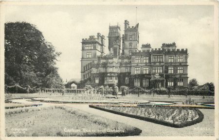
Carlton Towers [Grade I]
The house was started in 1614, probably to a design by John Smythson (Girouard 1967a, 178). To the north of the Jacobean house was added a wing before 1765. About 1777 a large range was built to the east by Thomas Atkinson that had a chapel and stables (Girouard 1967a, 179). This was remodelled in 1844-5 and again in 1873-5 in the Gothic style by Edward Welby Pugin as part of a much grander scheme. The design was only partially completed when Pugin died and no further external work was undertaken. The interior was completed between 1875 and 1890 by J F Bentley for Lord Beaumont.
‘Pumping House or Shed’ [Grade II]
Folly c1770 by Thomas Atkinson for Nicholas Stapleton, this is probably the building referred to in 1773 as ‘water house’ (29/15).
Ice house
Built before 1772, the remains of the circular ice house measure 4.30m in diameter, formed by a brick wall at ground level 800mm thick with what appear to be buttresses on the north and south sides - there may be others but these are currently covered with a thin layer of soil and vegetation [they are due to be excavated this year, 2016].The bricks are all handmade, typically 270mm long x 125mm wide x 65mm thick, bound with a thick lime mortar, all characteristic of a structure built in the late 18th century. The outer ring of the brick wall slopes upwards into the interior, suggesting there was a dome on top of the wall, which sprang up from ground level (initial survey by Ed Dennison, 2 March 2016).
Gardens and pleasure gardens
The area around the house has had a series of ornamental gardens dating from the construction of the house in the early 17th century. The west front was the original main entrance and it is likely that the knot garden referred to in 1659 was on this side of the house, as the best views would have been from there. The ‘four square’ garden with the raised walkway was constructed to the south of the house in 1672 and sometime before 1698, the ‘west hill garden’ was put in to possibly replace the now old-fashioned knot garden.
These early gardens remained until the landscaping undertaken in the 1760s and 1770s when the formal gardens were removed to allow the parkland to come right to the house. In the 1840s with the change in garden fashion, more formal elements were reinstated to the south and east with the new courtyard and entrance. To the north, shrubberies were added alongside the tree planting of the previous century. The final changes were undertaken in the 1870s and 1880s when the parterre and ‘Italian’ garden were added.
Kitchen garden
Kitchen garden prior to late 18C
From the archive documents, there were two productive areas prior to the construction of the present kitchen garden. The first was an orchard dating back possibly to the medieval house, as it is referred to as the ‘ould orchard’ in the early 17th century survey. The site is unknown but it may be the ‘crab orchard’ next to Quosquo Hall (see above). This or perhaps a later orchard is mentioned as early as 1659 and this continues throughout the 17th century as noted in the Household Accounts: ‘Paid more to John Walker July 21st 1698 for five days nailing [fruit?] trees to the walls – 2s 6d’ (2/48/13)
The second is the kitchen garden, probably in the walled area to the east of the stable block (see Figure 1). Within this area (and near to the stables to provide the dung for heat) were a series of glass-covered frames for melons and cucumbers as recorded on 1st April 1702. They cost in total £2 11s 8d (2/48/16), quite a significant sum when the gardeners were being paid 6-8d a day at that time.
Construction of the walled garden
Cowell’s (2005, 219) analysis and household accounts supports the view that the walled kitchen garden was constructed according to Woods’ 1765 plan. White’s later plan shows the walled garden as identical to Woods’. Although Woods appeared to have no common design for walled gardens, a significant number have rounded corners or apisidal ends (e.g. Wardour, Hengrave Hall, Wormsley) (Cowell, 1986, 1987a, 1987b).
Woods’ original plan shows a square walled garden with rounded corners on the north end. There is a central wall running east-west within the garden, with paths around 4 quadrant beds and the central wall. This hot wall seems an unusual feature as of Woods’ extant plans, only one other (Copford Hall, 1784), shows evidence of something similar, albeit in a kitchen garden with square corners (Cowell 2005, 184). The first mention in the accounts of it is in 1772, when reeds were purchased for its screens (29/13). The four small buildings housing the furnaces behind the wall are shown on the 1st edition OS map. It was used for supporting greenhouses later, as the 1893 sale plan and photographs (Snaith History Society, 69-70) show.
Woods’ plan shows three entrances to the walled garden: one in the mid-south wall, near the stables (still extant); one in the south-east corner (now gone), with a path around the outside to a (main?) entrance in the middle of the west wall (now gone). There is also a semi-circular area of beds shown north of the walled garden.
The current walled garden is 272ft x 272ft, occupying 1.70 acres. There is no reason to believe that the size has changed since originally constructed. The sale plan of 1893 shows the walled garden as very similar to that in the Woods’ plan, with the addition of glasshouses along the south side of the internal wall and to the north of the walled garden.
Development of structures within and without the walled garden
The construction of the walled garden coincided with the building of at least two greenhouses/hot houses before 1771. The one shown outside the new kitchen garden may be the ‘greenhouse’, a more decorative free standing building that was used to over-winter plants. The one inside the walled garden is more likely to be a ‘hot house’, a more utilitarian building with the heat being provided by ‘hot walls’. A second [smaller?] building, referred to in 1773 as a ‘new hot house’ was added outside to the east of the first and is shown on the 1808 map. These two buildings would seem to be the ‘vineries’ described in bills from glaziers and workmen between 1808 and 1813 (29/29 and 2/48/110a). The reference to a ‘peach-house’ in 1813 (29/29) when its flues were cleaned, repaired and pointed, is probably in the structure inside the walled garden.
Work by glaziers and a hailstone insurance policy in 1844 (2/11/44) may indicate that the existing structures were updated to include glass roofs and possibly extended. The structures listed in the policy were a large hothouse (891 square foot of glass), a succession house (595 square foot of glass) and a peach house (453 square foot of glass). To the north of the walled garden there were two vineries (192 square foot of glass each). In the melon ground, there was a Calcutta pit (254 square foot of glass) and portable lights [cold frames] (348 square foot of glass). Further glasshouses were added after 1849 along the middle internal wall, as they do not appear on the 1st edition 6” OS map, as well as another on the northern wall. The OS map also shows structures which could be furnaces/heaters for the internal wall. The vineries outside may have been rebuilt as the one to the east has disappeared and replaced by one to the north.
The sale plan of 1893 (ERA DDCL3299) gives details of the structures in the kitchen garden at that time. Within the walled garden, along the south side of the internal wall, were two peach houses 103 foot long by 10’ 9” wide, a greenhouse and storehouse 62 foot long, all heated by hot water pipes. These occupied the width of the garden (c.270’), with the greenhouse in the middle. Along the north wall was a vinery 59 foot long by 16’ 6” wide and a cucumber house 41 foot long. Two vineries of each 66 foot long by 16’ 6” wide, heated by hot water pipes, were to the north of the walled garden, along with potting sheds, office and tool house (Figure 2).
Photographs, probably taken in the 1930s (Snaith History Society), show glasshouses along the length of the internal wall and on the north wall, seemingly identical to the 1893 sale plan. By 1940 the house had been lent to the military and there is a statement in the correspondence with the tax office that the garden is not being used commercially by Lady Beaumont (2/12/9). The commentary associated with photographs of the walled garden (Snaith History Society) indicates it was operated as a commercial market garden by. By 1954, the garden was a thriving concern of five acres with Robert Paul as head gardener. That year he appointed 15 year old John Mells as the first West Riding apprentice in the garden under a scheme for training in horticulture (Yorkshire Post).
Planting within kitchen garden
In the first kitchen garden of the 17th century, typical food crops were grown. In 1698, Sir Miles notes that he:
‘Paid to John Walker for two quarts of peas to sow in the gardens – 1s 6d, Paid to John Walker for cabbage plants – 9d and ‘Paid to Sir Tho: Yarburgh’s gardener [of Snaith Hall] for collifloure [cauliflower] plants – 1s’ (2/48/13).
However in 1702, more ambitious crops were being planned by the construction of melon and cucumber frames. The expensive glass was separately itemised (2/48/16):
‘Paid to Richard Birch for 27 foot of new glass for glass case (?) in the garden which is made for mellons & concumbers [cucumbers] – 13s 6d; Paid to Richard Birch for glass for this frame for Mellons – 12s; Paid more to Richard Birch for glass for this frame for Mellons -14s 6d’
Together with the frames:
‘Paid to Richard Mawhood for 4 deales [short planks of wood] for makeing a frame for the garden, to be glassed for preserving Mellons and cewcumbers – 5s 4d; Paid more for deales for another frame for Mellons - 6s 6d’.
By the 1760s, the latest fashion was for growing pineapples. The plants were very expensive to buy and grow. In 1760 some were bought for Hartwell (where Woods built a pinery) at a cost of 2s 6d each for succulent (i.e. immature) plants, 7s each for fruiting pineapples and 6s each for ‘large store plants’ (BCRO D/LE/11/10). To grow them needed tanner’s bark. In 1767, £6 13s 6d is spent on bark and by 1772, this had increased to £8 5s 10d (29/13) and then there was the labour required to man the stoves. However they were worth it as these fruit were shown off at the London dinner table. On the 29th May 1773, it is recorded ‘Mr Clark [the gardener] box to London with grapes and Pines, 17 pounds’ (29/15). The ‘hothouse’ built in 1767 was probably used to overwinter them and then they were transferred in pots to the hot beds in the frameyard.
By the early nineteenth century, the focus seems to have shifted to peaches and nectarines and to the skills of the head gardener, John Seymour, who was employed from around 1806 to 1847. According to the articles in the new gardeners’ magazines, Seymour invented a new system for maximising fruit yield. The first article in Loudon’s Gardener’s Magazine makes reference to the planting of a two-year old peach tree in 1806. There is a bill from Telford’s, which gives two possible candidates, bought on the 16 December: ‘Soucher’s? Minion, 3s or Chancellor, 3s (2/48/110a). By 1824, this tree had extended 45ft upon a 10ft wall and was very productive (Seymour, W. 1826 & Duff, 1826). John Seymour writes his own account in 1827 of his method of fan-training the fruit against a wall and then systematically pruning to ensure fruiting only occurs on year old wood.
Those who saw the peach trees were very impressed but others debated the efficacy of the method compared with their own (Hayward, 1832). Articles, in the Horticultural Register and Gardener’s and Forester’s Record, laud Seymour’s inventive method of training peach and nectarine trees (Harrison, 1832; Dyson, 1832; Seymour, W., 1832; Tasburgh, 1833; Dyson, 1833). The descriptions indicate that the peaches and nectarines were grown against a wall and protected by woollen netting or canvas against frosts in the blooming season. Tasburgh’s 1833 article lists the yield of nectarines within the garden in 1832 (fig x) and he claims the fruit competes in quality with those from the celebrated fruit grounds at Montreuil, France. Seymour’s method of training peach and nectarine trees seems to become an established one as there are further references to ‘Seymour’s method’ in later articles in the Gardener’s Magazine (e.g. Loudon, 1839).
The Leeds Times (1839) also reports the abundance of the nectarine tree described in Tasburgh's article (fig y).
Fig y: Leeds Times September 14 1839 report of Carlton Hall’s fruit.
There are further bills in the archive (2/48/110a) showing the purchase of fruit trees, perhaps indicating Seymour was also experimenting with different varieties. From Telford’s of York, the following were bought:
- 1 Nov 1808 - 2 peaches [not specified], 4s
- 9 Nov 1808 - 1 Purple Hative peach, 5s
- 18 Feb 1809 -1 Moorpark apricot, 2s and 1 white heart cherry dwarf, 1s 6d.
The possible rebuilding of the greenhouses within the kitchen garden, may have led to a reorganisation with the purchase of the following dwarf trees (2/48/110b):
| Date | Supplier | Fruit type | Cost |
| 13 Nov 1845 | Richard Millon of Pontefract | 6 ‘Moor Park’ apricots, | £1 1s |
| 4 peaches | 14s | ||
| 2 nectarines | 7s | ||
| 10 peaches, plums and cherries | £1 8s | ||
| 29 Dec 1847 | Backhouse Nursery of York | 1 ‘Violette Hative’ peach | 3s 6d |
| 1 ‘Early Anne’ peach | 5s | ||
| 1 ‘Royal George’ peach | 3s 6d | ||
| 1 ‘Elruge’ nectarine | 3s 6d | ||
| 1 ‘Washington’ plum | 2s 6d | ||
| 2 ‘Magnum Bonum’ plum | 4s | ||
| 1 ‘Victoria’ plum | 2s 6d | ||
| 1 ‘Winter Windsor’ pear | 2s | ||
| 1 ‘Suffolk Mouthwater ‘pear | 2s 6d | ||
| 1 ‘Summer Franc real’ pear | 2s | ||
| 1 ‘Van Mons Leon Le Clerc’ pear | 2s 6d | ||
| 1 ‘Dunmore’ pear | 2s 6d | ||
| 1 ‘Franc Real d’hiver’ pear | 3s | ||
| 1 ‘Easter Buerre’ pear | 3s 6d | ||
| 1 ‘Romana’ apricot | 3s 6d | ||
| 1 ‘Marie Louise’ pear | 1s 6d |
It was not only prized fruit that were important to John Seymour. The local nurseries also supplied vegetable seeds with surviving bills (2/48/110a) again attesting to the variety of vegetables sown. For example, in 1807 to 1809 Telford’s of York supplied varieties of seeds: peas, beans, turnips, cabbage, carrot, broccoli, cauliflower, onions, along with cucumber, celery, mustard, cress, sweet marjoram, sweet basil, curled parsley, salsify and scorzonera. In 1830, Seymour is reported to have developed a large white celery:
‘It has been grown by him [Seymour] to 6 lb. weight each head; and a few plants received by Mr. James Kingston, gardener to Philip Saltmarsh Esq., of Saltmarsh Hall, near Howden, Yorkshire, from Mr. Seymour, weighed 13lb. a head after the soil and decayed leaves had been taken off, and was 5 ft. high. Their stalks were exhibited at the Doncaster Horticultural Show, where they were much admired’ (Gardeners’ Magazine 1839, 96)
Gardeners at Carlton won prizes at agricultural and horticultural shows across the north of England, predominantly for trays of fruit, demonstrating the variety being grown but also for vegetables and flowers. The newspaper reports show prizes being won consistently from 1852 until 1913. Indeed James (son of John) Seymour’s standing as head gardener led him to be the judge for fruit and vegetables in the Snaith Show from 1865 to 1867 (Yorkshire Post 5 July 1867 and Leeds Mercury 13 July 1866, 8 July 1865).
Three examples spanning the 60 year period illustrate the productivity of the garden:
At the 1852 Kirkheaton Show, William Plews, gardener to Lord Beaumont, was among the successful exhibitors. He won 1st prize for his tray of fruit containing 2 bunches of white grapes, 2 bunches of black grapes, 1 melon, 6 dessert apples, 6 dessert pears, 6 plums, 1 pint gooseberries and 1 pound currants. He also won 1st prize for the following 6 figs, 6 peaches, 6 baking apples, 6 dark plums, 6 white magnum plums and 2nd prize for 6 dessert apples, redcurrants (Huddersfield Chronicle 4 Sept 1852).
In 1877, Thomas Haigh, now the gardener at Carlton, exhibited at the Thornhill Show. He won prizes for white and black grapes; white, red and black currants; baking and dessert apples; Tartarian crabs [apples]; yellow and green gooseberries; white, green and dark plums; a heat flavoured melon and peaches in the fruit classes and for gladiolus and dahlias in the flower section (Huddersfield Chronicle 11 August 1877).
By 1910 at the Normanby Park show, Lady Beaumont and head gardener William Nicholls were awarded many prizes:
Vegetables: 3rd white round potatoes; 1st carrot stump rooted; 2nd dwarf beans; 2nd cos lettuce; 1st parsnips; 3rd round beet; 2nd celery; 1st cucumber; 1st peas; 1st (silver medal best in show) potatoes not more than 8 varieties; 1st 6 distinct kinds potatoes; 1st collection of potatoes.
Fruit: 1st black grapes; 1st white grapes; 2nd peaches; 2nd nectarines; 2nd melons; 1st apples; 1st redcurrants; 2nd loganberries (Hull Daily Mail 30 July 1910)
The kitchen garden continued to be productive as a family-run garden until WW2. The 1938-40 garden accounts show sales of produce. However with garden labour costs (including coal and seeds) outstripping the revenue, the gardens had to subsidised by Lady Beaumont:
| Year | Sales of produce | Garden labour costs | Subsidy |
| 1938 | £339 3s 7d | £929 6s 3 ½d | £771 1s 6 ½d |
| 1939 | £513 15s 1 ½d | £930 6s 3 ½d | £704 16s 4 ½d |
| 1940 | £509 13s 6d | £937 14s 5d | £679 18s |
Park and plantations
The survey of c1600 mentions a ‘High Parke’, which was still there in 1753 when the valuation of timber was undertaken (36/8). The map of the same date shows a t-avenue of trees to south-east of house (see Figure 3), so this perhaps is the High Parke. There is also an avenue shown to the east of the main road into Carlton village, so this could be the site of the ‘Old Park’ referred to in the field survey of 1725. By 1771, these areas had been opened up to form a larger parkland area, implementing the start of the landscaping plan by Woods.
The survey of 1789 says that Carlton Park has 102 acres (4/36/12) [again in 1793] and this would appear to cover the area marked on the Enclosure map of 1808 as ‘Hall Garth’ (NYRCO WRRD B 26 [MIC 601]). This also replicates the area shown on White’s plan as parkland with a shelterbelt to the north and east and planting around the new lake. In the 1839 survey, the ‘Woods, Plantations & Ponds’ came to 152 acres, 3 roods and 10 perches (36/31), as the area to the south of the western end of the lake had been included. The park was extended eastwards in the 1840s and again in the 1870s. By the time the estate had come up for sale in the 1893, the park was 279 acres (ERA DDCL3299). The current size of the park is about 300 acres. The changes in the extent of the parkland can be seen in Figure 3.
Butt Hole Plantation
To the north of the house and kitchen garden. The name ‘Butt Hole’ first appears on the 1771 map and would appear to be part of the landscaping as suggested by Woods’ plan. There is a significant depression in the area and would suggest that this was made as an artificial pond to provide ice for the newly built ice house nearby. Planting around it would have afforded shade.
Green Gates Plantation
To the north-east of the house and kitchen garden, extant by 1893 and probably created in the 1870s. Name dates from the early 17th century as listed on the survey of the time.
Sand Hole Plantation
South of Mill Lane and probably created in the 1870s.
Kennel Plantation
South of Mill Lane, east of Sand Hole and created in the 1870s.
Drain Plantation
Eastern boundary of park extant by 1893 and probably created in the 1870s.
Baffin Hill Plantation
Southern boundary of park extant by 1893 and probably created in the 1870s.
Ell Pond Plantation
Adjoining eastern end of Fishpond extant by 1893 and probably created in the 1870s.
Rookery & Wilderness
Surrounding western end of Fishpond and created in the 1780s, following White’s plan.
Half Moon Wood
In centre of park extant by 1893 and probably created in the 1870s.
Duck Pond Wood
In centre of park surrounding duck pond, extant by 1950
Books and articles
Cowell, F. 1986 ‘Richard Woods (?1716-93): A Preliminary Account: Part I. 'Woods Surveyer at Chertsey in Surry' and at London Stile’, Garden History 14, 2: 85-119.
Cowell, F. 1987a ‘Richard Woods (?1716-93): A Preliminary Account. Part II 'Mr Wood of Essex', Garden History 15, 1: 19-54.
Cowell, F. 1987b. ‘Richard Woods (?1716-1793): Preliminary Account. Part III. Influences, Style and Working Methods’, Garden History 15, 2: 115-135.
Cowell, F. 2005. ‘Richard Woods (1715/6-1793): Surveyor, Improver and Master of the Pleasure Garden’. PhD thesis, University of East Anglia.
Dyson, H. 1832. ‘On training peaches and nectarines’, Horticultural register 1 September, Article 1.
Dyson, H. 1833. ‘On training peach and nectarine trees’, Gardener’s and Forester’s Record 1 July, Article II.
Farrer, W. 1915. ed. Early Yorkshire Charters Vol II. Edinburgh: Ballantyne, Hanson & Co.
Farrer, W. and Clay, C. T. 2013. Early Yorkshire Charters: Volume 6, The Paynel Fee. Cambridge, Cambridge University Press.
Fowler, J. T. 2013. The Coucher Book of Selby. Cambridge, Cambridge University Press.
Girouard, M. 1967. ‘Carlton Towers, Yorkshire – I’, Country Life January 26, 176-180.
Harrison, J. 1832. ‘On training peaches and nectarines’, Horticultural register 1 June, Article 1.
Hayward, J. 1832. ‘On Mr. Hayward's Mode of training Peach Trees, as compared with Mr. Seymour's Mode’, Gardener’s Magazine Art. VI.:653.
Illingworth, W. 1818. Placita de quo warranto, temporibus Edw. I. II. & III. London, G. Eyre and A. Strahan.
Jacques, D. 1983. Georgian Gardens: The Reign of Nature. London, B.T. Batsford.
Loudon, J.C. 1826. ‘On a new Mode of training the Peach-tree, invented by Mr. J. Seymour, and communicated by Mr. William Seymour, Gardener at Weddington, and Mr. Duff, Gardener to the Earl of Grosvenor, at Eton Hall’, Gardener’s Magazine 1, Art. VIII: 128.
Loudon, J.C. 1839. ‘Recollections of a Tour chiefly between London and Sheffield, made during the last three Weeks of May, 1839’ Gardeners Magazine, August, Article I.
PRO 1900. Calendar of the Close Rolls, Vol 1, Edward I (1272-1279). London, Eyre & Spottiswoode.
Robinson, J. M. 1979. ‘A Catalogue of the Architectural Drawings at Carlton Towers, Yorkshire’, Architectural History 22: 116-180.
Seymour, J. 1827. ‘Explanatory Remarks on Mr. Seymour's Mode of training Peach Trees’, Gardener’s Magazine 2, Article XVII: 295.
Seymour, W. 1832. ‘On training peach and nectarine trees’, Horticultural register 1 October, Article III.
Snaith & District History Society (1993) Pictures from the Past of Carlton juxta Snaith.
Tasburgh, M. 1833. ‘On training peach and nectarine trees’, Gardener’s and Forester’s Record 1 July, Article I.
Turnbull, D. 1990. ‘Thomas White (1739-1811): Eighteenth Century Landscape Designer and Arboriculturist’. PhD thesis, University of Hull.
Online newspapers
Entries relevant to produce from Carlton gardens c.1770 to c.1920 were found in the following newspapers: Huddersfield Chronicle; The Yorkshire Post; The Leeds Times; The Yorkshire Herald; The Sheffield Daily Telegraph; The Leeds Mercury; Hull Daily Mail; North-Eastern Daily Gazette; Morpeth Herald and Reporter; The Shields Daily Gazette; The Staffordshire Sentinel.
Primary sources
Buckinghamshire County Record Office (BCRO)
D/LE/11/10 Accounts of Richard Woods,10 October 1759 – 22 October 1760
Carlton Towers Estate
‘A Design for the Improvement of Carlton, Yorkshire the seat of Thos Stapleton Esq by Richd Woods 1765’
‘A Plan for the Improvement of Carlton in Yorkshire the seat of Thos Stapleton Esq by Thos White’
East Riding Archives, Beverley (ERA)
| DDCL3390 | Map of the estates of Thomas Stapleton at Carlton | 1753 |
| DDCL3299 | Sale plan of the Carlton estate | 1893 |
Hull History Centre (HHC)
Papers of the Stapleton Family (Lords Beaumont) of Carlton Towers (U DDCA)
| 4/147 | Sale of Timber | 10 May 1742 | ||||||
| 4/177 & 4/178 | Sale of Timber | 1794 | ||||||
| 4/206 | Plan of lands in and about Carlton | 1839 | ||||||
| 5/14,15 & 18 | Farm leases | 2 October 1784 | ||||||
| 29/13 | Garden Accounts | 1765-1773 | ||||||
| 29/14 | Garden Accounts | 1776-1777 | ||||||
| 29/15 | Estate Accounts and Memoranda | 1772-1779 | ||||||
| 29/29 | Miscellaneous Accounts and Vouchers | 1758-1839 | ||||||
| 36/3 | ‘Survey of mine closes of the demaine of Carlton whereof the ould orchard was one’ | c1600 | ||||||
| 36/8 | Valuation of timber in the estate of Nicholas Stapleton at Carlton and Camblesforth | 1753 | ||||||
| 36/12 | Survey and valuation Carlton | 1789 | ||||||
| 36/31 | Survey and valuation of the lands of Thomas Stapleton incl Carlton | 1839 | ||||||
| 36/34 | Survey plan of estate of Thomas Stapleton at Carlton | c1771 | ||||||
| 2/57/6 | Survey of woods in Carlton and Camblesforth | Early 19th century | ||||||
| 2/48/1-18 | Account Books of Sir Miles Stapleton | 1656 – 1705 | ||||||
| 2/11/17 | Field Book ‘Notes of Survey’ | 1725 | ||||||
| 2/11/44 | Hailstone policies | 1844 - 1847 | ||||||
| 2/12/9 | Garden Accounts | 1938 - 40 | ||||||
| 2/48/94b | Estate Accounts | 1870 - 74 | ||||||
| 2/48/95 | Receipt book. Amounts paid by William Bullock on behalf of Thomas Stapleton | 1776 - 1781 | ||||||
| 2/48/110 | Carlton estate vouchers (a) 1798 - 1801; 1806 - 1810(b) 1845 - 1846; 1848 - 1849(c) 1850 - 1854 | 1798-1854 | ||||||
London School of Economics Archives (LSEA)
COLL MISC 0644 Estate Account Book for Carlton and Bedale 1771-1791
North Yorkshire County Record Office (NYCRO)
WRRD B 26 [MIC 601] Enclosure Map of Carlton 1808
Royal Institute of Architects Archive (RIBA)
7024 Photograph of Carlton Towers west front 1880
Maps
1st Edition OS (1849) 6” to 1 mile


