From as early as the mid-13th century, the owners of Denton have wanted to shape and use the dramatic natural landscape stretching from the river Wharfe to the high moorland nearly 200m above it. The Fairfax family acquired the estate by marriage in the early 16th century. By 1596, they had created extensive parkland covering about 700 acres, over half of which had been put in by Sir Thomas Fairfax not long before the survey was taken. His son (later 1st Lord Fairfax) though had grander ambitions and built a large new house on or near the site of the present hall in the 1620s.
After the upheavals of the Civil War, Denton became a secondary property for the Fairfax family but in 1688, Thomas (5th Lord Fairfax) returned to live there. He made improvements to the hall and possibly the grounds but incurred debts that meant the estate had to be sold after his death in 1710. It was acquired by James Ibbetson in 1716 and thus began a period of 200 years during which the Ibbetson family developed the designed landscape that we see today. The Jacobean hall had suffered two fires by 1743 and on inheriting the estate in 1768, Sir James Ibbetson decided to build a brand new house to a design by John Carr. He spent over £10,000 on this, however there is no archival evidence indicating any changes made to the grounds at this time.
Sir James Carr Ibbetson took over the estate from his father in 1798 and it may be during his tenure that the extant lake, remodelled parkland and walled kitchen garden, noted in c.1810, were put in place. He also probably added the new lodges to provide an entrance from the east by 1817. His brother, Sir Charles, continued to add to the designed landscape from 1825 with significant tree planting and improvements to the glasshouses. On Sir Charles’ death in 1839, Denton was let to tenants until 1861 when his daughter, Laura, and husband, Marmaduke Wyvill, took up residence. They made a few changes including extending the pleasure grounds to Scales Gill. They also owned the Constable Burton estate and gradually this became their main focus, so Denton was rented out and eventually sold in 1920. Subsequent owners have made few changes and the landscape remains as it was designed by the early 19th century.
Estate owners
Denton became part of the lands of the archbishop of York (manor of Otley) in the 10th century and by the mid-13th century, the tenants were the Vavasour family. Agnes Vavasour married Sir Bernard Brocas sometime before 1354 and it stayed with the Brocas family until its acquisition by John Thwaites c. 1430. Sir William Fairfax of Steeton married Isabel, daughter and heir of Thomas Thwaites, c. 1518 and the manor of Denton continued in the possession of the Fairfax family until its sale in 1716 to James Ibbetson of Leeds.
James Ibbetson’s son, Samuel, inherited the estate in 1739 and on his death in 1768, it went to his nephew, Sir James (2nd Bt) who died in 1795. His son, Sir Henry (3rd Bt), died without a direct male heir and so the estate devolved to his brother, Charles (4th Bt) in 1825 and then to Charles’ son, Charles Henry (5th Bt), in 1839. On the latter’s death in 1861, it was inherited by his sister, Laura Wyvill and remained in the Wyvill family until 1920 when it was bought by Lord Illingworth. Five years later he sold it to Arthur Hill. In 1976, it was acquired by the building firm of NG Bailey following the death of Mrs Hill.
Key owners responsible for major developments of the designed landscape and dates of their involvement:
Mauger le Vavasour?
John Thwaites c. 1430 - ?
Sir Thomas Fairfax 1558 – 99
Thomas, 1st Lord Fairfax 1599 – 1640
Thomas, 5th Lord Fairfax 1688 – 1710
James Ibbetson 1716 – 1739
Sir James Ibbetson 1768 – 95
Sir Henry Carr Ibbetson 1795 – 1825
Sir Charles Ibbetson 1825 – 39
Marmaduke and Laura Wyvill 1861 – 96
Early history of the site
Denton had been given to the archbishop of York as part of his manor of Otley in the 10th century. By 1086, although there was over 4,000 acres of ploughable land and 25,600 acres of woodland in the manor of Otley, it was described as possibly waste in the Domesday book (https://opendomesday.org/place/SE1448/denton/ consulted 11 September 2024). By the mid-13th century, the tenant was Mauger le Vavasour. In 1253, there was a grant of free warren to him for his demesne lands in Denton and Askwith, provided that they are not within the king’s forest i.e. the Forest of Knaresborough to the north (PRO 1903, 433). However there are no records as to whether he had an enclosed park here. The manor transferred to the Brocas family when Agnes le Vavasour married Sir Bernard Brocas before 1354. A description of the manor from 1429 suggested that if there had been a main or manor house, it was ruinous:
Joan, widow of Sir Bernard Brocas junior held the following in demesne as of fee. Denton in Wharfedale, the manor, held of John, archbishop of York, as of his manor of Otley, service unknown. There is a site, worth nothing yearly; 100a. [arable] land, each acre worth 6d. yearly; 20a. meadow, each acre worth 12d. yearly; 10a. wood, worth 20s. yearly; 100a. pasture, each acre worth 6d. yearly; a water-mill, worth 20s. yearly; and perquisites of court, worth 3s. 4d. yearly (PRO 2004, 127).
By c.1430, John Thwaites had acquired manor of Denton probably by purchase (Howard 1876, 276). It is possible he built the manor house that was later occupied until the end of the 16th century although none is mentioned in the Inquisition Post Mortem of his descendant, John Thwaites of Hardingham, Norfolk on the 24 June 1506 noting lands he owned:
Manors of Denton and Askwith, and 40a. land, 300a. pasture, 200a. meadow, 1000a. moor, 20a. wood and 10s. rent in Denton; and Askwith; whereof the manor of Denton; and lands &c. there, worth £20., are held of the archbishop of York, service unknown (PRO 1955, 170).
Sir William Fairfax of Steeton married Isabel, daughter and heir of Thomas Thwaites of Denton and granddaughter of John, c. 1518 and for the next two centuries, Denton became an important estate for the Fairfax family. On the death of Sir William in 1558, his estates were divided with his eldest son, Sir Thomas, being given Denton and Nun Appleton, near York. Just before Sir Thomas’ death, there was a survey from 1596 (NYA ZFW4/2/15) that gives the earliest record of the designed landscape. There were three distinct areas within the estate: Denton Hall, Carr house and Hollinghall with the first having just over 1224a out of a total of 1607a. There was nearly 700a of parkland including ‘launds’ (open areas for grazing) associated with the Denton Hall demesne:
The west park 108a
The ox close & the laund about the west parke 23a 24p
The red deer park 29a 36p
The east park 30a 3r
The hundwith and the park heads 42a
The east launde 23a 12p
Lodg[e] Hill 2a 1r 20p
The new park 442a
When this parkland was created is not clear, although it is likely to have been sometime in the 16th century, with the large ‘new park’ a recent addition. A map from 1716 (private collection) shows the location of these areas (Figures 1 & 2). The new park was created to the north of the existing east and red deer parks. In the vicinity of the current hall was Lodge Hill between the east park and the red deer park, where there would have been a (hunting) lodge. The manor house or hall was probably to the southeast, being nearer the river for access, with the survey noting 9½ acres as ‘the house close and the little orchard’. On the 1716 map, there was an orchard shown south of the fishpond and the adjacent area was called ‘Hall Fields’, indicating a possible location for the hall (Figure 3). An inventory of its contents in 1596 (NYA ZFW/16/1) showed it had at least 20 rooms.
Sir Thomas Fairfax inherited the estate in 1599. By 1620, he had built or had started to build a new hall as a survey of the ‘Demaine of Denton’ that year (WYASW JG000926) listed ‘The grounds between the new and old house’. In 1627, he was created Viscount Fairfax of Cameron and the improvements to the estate may well have been prompted by his new position. The new hall had 19 hearths by 1672, which was a similar size to other important houses at the time. Although Thomas’ son, Ferdinando (2nd Lord Fairfax), lived at Denton until his death in 1648, Thomas (3rd Lord Fairfax) preferred their other property of Nun Appleton where he died in 1671. As he had no male heirs, he was succeeded by his cousin, Henry, as the 4th Lord Fairfax, who did reside at Denton as Ralph Thoresby recorded meeting him there on 1 June 1684 (Hunter 1830, 176).
Thomas (5th Lord Fairfax) succeeded his father in 1688. A survey from 1695 (WYASW JG000926) listed fields measuring just over 133a belonging to the hall and a further 323a divided between small tenant farms. The other land at Denton is not measured but a list of ‘demesne lands’ is the same as previous surveys indicating no major change in the designed landscape. Ralph Thoresby visited again in 1702 between 6 and 8 September. He noted that Denton Hall was ‘a strong and stately building’ (Hunter 1830, 381) and spent time ‘viewing the house (wherein my Lord is making several alterations, which are both noble and convenient) and gardens’ (ibid, 396). The hall had a courtyard to the south and east and is shown in Samuel Buck’s sketch of c.1720, together with the chapel to the west (Hall 1979, 193). To the northeast of the hall was a walled garden divided into four and adjacent to it is a nursery area for trees (Figure 4).
Lord Fairfax may also have been planning to plant an avenue of lime trees as his son, Robert (6th Lord Fairfax), was asked in 1712 by Admiral Robert Fairfax of Steeton and Newton Kyme to:
Give me leave to acquaint your Lordship that in your Father’s lifetime he was pleased to direct Mr. Bankes [steward], at Denton, that I should have a quantity of lime trees of his Lordship’s sowing there, to set an avenue to my house in Yorkshire (Markham 1885, 228).
After the 5th Lord Fairfax’s death in 1710, his will directed that property in Yorkshire should be sold to pay off the debts he had incurred and ‘Bankes [estate steward] also had orders to destroy the deer at Denton’ (ibid, 300). In 1716, the property was bought by James Ibbetson and a map of the manor was made at this time. The parkland north of the hall, dating from the late 16th century, was still there but had reduced to c. 380a. It comprised of the East Park (c. 30a, unchanged?), ‘Deer park’ (c. 142a including the old ‘red deer park’), The Warren (c.35a) and the High Park that went to edge of Denton moor (c. 178a) (Figure 1). The old west park now was just a wooded area (Figure 2) and all the area south of the hall were fields (Figure 5).
In 1734, the hall burnt down for first time and was rebuilt. Following the death of James Ibbetson in 1739, his son Samuel inherited but in 1743, the hall burnt down for a second time and was again restored. This must have incurred further expense for the estate. The Ibbetson Estate Sale Act of 1755 ensured that there were funds for his brother’s (Sir Henry 1st Bt) three sons by the sale of properties entailed in the will of their father, James (Journal of the House of Lords Volume 28, 1753-1756, 306-7; PA HL/PO/PB/1/1755/28G2n46). This may have been prompted by the fact Samuel only had a daughter and Denton had to be passed down the male line. Samuel died in 1768 with his nephew, Sir James (2nd Bt), inheriting the estate.
Chronological history of the designed landscape
1769 – 1839
Sir James wanted to improve the family estate and c. 1772, he started work on the current mansion that was designed by John Carr. The cost in 1772 of the building work was £7,710 12s 3d (WYASW JG001519) and in total £10,541 18s 7d had been spent by 1777 on the buildings and furniture (The Chippendale Society LEEAG CHIPSOC 1973 1 Bill). In 1776, the Ibbetson Sale Act was passed that raised £3,600 from his properties (PA HL/PO/PB/1/1776/16G3n85) to help pay for this. The effect on the designed landscape of the new house was unclear as it replaced the former building. The 3rd edition of the map by Jeffrey published in 1800 (Figure 6) shows a similar layout to his earlier map from c. 1767-70 (Figure 7), however the public road that previously ran though the lower part of the park had been moved further south. Sir James Ibbetson died in 1795 and his son, Henry Carr (3rd Bt) inherited the estate.
In 1798, many mature trees were sold including prime specimens of oak, lime and walnut from the East Park and 94 mixed trees from Hundwith Gill (Leeds Intelligencer, 26 February), suggesting that Sir Henry was making changes to the landscape. A written survey of c. 1810 (NYA ZFW 4/12/16) details the alterations but when they were implemented is unclear. A key feature was a new lake covering just over 3 acres south of the hall. Its construction involved removing the mill pond, the rerouting of the stream that ran through the parkland to the river and the enlargement of the old fishpond. To the northeast, a walled kitchen garden (2a 4p), adjoining flower garden to the south (1a 38p) and an orchard to the north (1a 17p) had been added.
Areas to the south of the public road that previously had been fields were now parkland and later was known as ‘Low Park’ (ibid). Together with the former East Park and southern section of the old Deer Park, this formed nearly 189 acres of open parkland around the hall. The northern part of the old Deer Park was now separated into two sections: ‘High Park’ and ‘St Helens’ with an area of woodland to the north called ‘Lady’s Walk’. All these features are shown on the 1st edition 6” OS map (Figure 8).
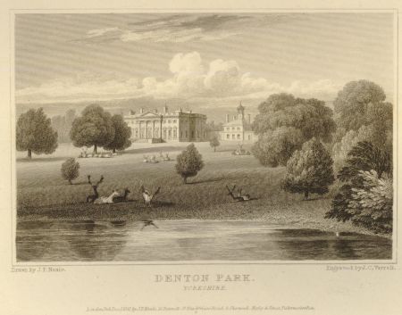
The Greenwood map surveyed in 1817 (Figure 9) showed the twin lodges to the east were now in place. 125 oak, ash, elm, beech, sycamore and alder were sold from the East Wood in 1814 (WYASW JG001519) to further open up this area. A drawing by Neale made c. 1818-20 (Figure 10), shows the hall from south of the lake, looking across the open parkland to the east. Charles Ibbetson took possession of the Denton estate in 1825 after his brother’s death and continued developing the designed landscape. In 1827, he was granted a diversion of a highway in Denton, taking the road northeast out of the village away from the western section of the Well House Plantation (WYASW QT3/4/5). The area around the former road was planted in 1830 with 10,000 varied shrubs ‘for underwood’ and 3,000 each of blackthorn, alders and birches bought from Oxley Hanks & Co, Pontefract on 2 March (WYASW JG000965).
Sir Charles also made improvements to the buildings in the grounds. There is an estimate for a wall round the ice house (ibid) in 1826 and bills for a new boiler in the pine house (ibid), a cast iron steamer from Zebulun Stirk of Leeds (WYASW JG001519) and glazing in conservatory, stoves, peach houses, ‘new pine stove’ and green house (ibid). It is not clear whether these structures were already in place or newly constructed. The following year, a new fireplace in greenhouse was added (WYASW JG000965) together with new castings for the stoves in the gardens (WYASW JG001519) and work in the pine house and fig houses (ibid). In the wider estate, there was more planting as c. 75,000 forest trees bought in 1833 (WYASW JG000965) with a further 20,000 trees and 1,200 shrubs in 1833 (ibid) and 5,300 shrubs in 1837 (ibid).
Later history
Following the death of Sir Charles in 1839, his son (Sir Charles Henry, 5th Bt) decided to live elsewhere as the mansion and grounds were offered for rent (The Morning Post, 4 May 1842). The tenant from c. 1848 until 1860 was Edward Akroyd. Surveys from 1857 and c. 1860 (NYA ZFW 4/2/19 & M) during the tenancy of Akroyd show an unchanged layout from the earlier survey of c. 1810 (Figure 8). Charles Henry Ibbetson decided to return to Denton in September 1860 but died in the following July (Leeds Mercury, 9 July 1861). The estate was inherited by his sister, Laura Wyvill and she and her husband, Marmaduke Wyvill junior, moved to Denton. In 1862, they applied for a loan of £5,000 to drain land in Denton Park and Askwith (Yorkshire Gazette, 1 March) and embarked on a programme of tree planting probably in the park (NYA ZFW 4 Box 3). They also repaired the fishpond in August 1862 (ibid) and possibly remodelled the grounds around Scales Gill at this time. This involved extending the walk north from the eastern extent of the Ladies Walk Plantation with stepping stones crossing the beck (Figure 11).
In 1872, the Wyvills inherited Constable Burton, although they continued to occupy Denton until they rented out the hall and immediate grounds in 1891. The Denton estate paid for a bridge over River Wharfe at Ben Rhydding in 1887 at a cost of nearly £1000 (NYA ZFW 4 Box 3), presumably to allow them to travel to the estate via the Ben Rhydding station rather than the one from the more distant Ilkley. By 1889 (Figure 12), they made various changes including adding glasshouses in the kitchen garden and the clearance of northern section of East Wood to create more open parkland. They also increased the plantations to the southwest corner of the main park and added a small pond there. This required the removal of the brickworks, probably after 1876 as sales ledger for it ends that year (ibid).
Marmaduke Wyvill died in 1896 and his son, Marmaduke D’Arcy, succeeded to the estate. The following year to raise funds, he decided to sell £400 worth of timber from Denton over the next 4 years (NYA ZFW 4 Box 5). The trees were to come from the following: Low Park (from sunk fence opposite saw mill and round the belt), clumps in the Park, Lodge Plantation & the Gills, top of West Park and all Bow Beck and western boundary woods (ibid). The Wyvill family decided to return to Constable Burton and with the death of their long-term tenant, John Wormald, in March 1901, decided to sell Denton in May 1902 (NYA Z1630/5/1). However it failed to find a buyer (Yorkshire Evening Post, 27 May) and Mrs Wormald remained until the lease expired the following year. The tenancy was then taken on by Mrs Catherine Salt (Saltaire Collection, 2018.40.25).
In July 1919, the estate was sold to Albert, Lord Ilingworth, who had been the tenant from 1912. However he decided to sell it in June 1924 and the new owner was Arthur Hill. It remained with the Hill family until 1976, when it was acquired by NG Bailey, the current owners. The designed landscape stayed largely unchanged into the 1970s (Figure 13). Some of the parkland is now arable but all areas of historic woodland remain, together with lake and outer walls of the kitchen garden.
Location
Denton Park is 2 miles (3.5km) northeast of Ilkley and 4 miles (6.5km) northwest of Otley.
Area
The historic designed landscape covered c. 415 acres (168 ha) from the early 19th century onwards. However the ‘demaine’ belonging to Denton Hall in 1596 was just under 1225 acres and included the west park of 108a and the northern parkland of 671a.
Boundaries
The northern boundary follows the Lady’s Walk Plantation from the public road at SE 148 497 to Scales Gill at SE 155 495 and then goes north to the edge of the Scales Gill plantation at SE 157 501. The eastern boundary is marked by the plantations that are adjacent to Hundwith Gill from SE 158 500 to the northern edge of Lodge Plantation at SE 154 487. It then follows the eastern edge of Lodge Plantation and Low Park to SE 151 477. The southern boundary is formed by Low Park to SE 148 478. The western boundary lies next to Low Park Plantation to SE 145 482 and then Chapel Plantation to SE 144 489, when it meets the village road in Denton. It then continues north again following the line of the plantations, Well House and Lady’s Walk, to SE 148 497.
Landform
The underlying bedrock covering all of Denton Park is Marchup Grit Sandstone, which is overlaid with superficial sedimentary deposits of gravel within a mix of sand, silt and clay. Most of the parkland to the north and east has slowly permeable, seasonally wet slightly acid loam and clay soils with moderate fertility. Southeast of the fishpond, the soil is freely draining loam with moderate to high fertility.
Setting
Denton lies in the National Characterisation Area 21 of the Yorkshire Dales, a landscape of high, exposed moorland dissected by sheltered valleys or dales. A number of major rivers rise on the high moorlands and carve out river valleys, gorges and waterfalls. The hall sits at 97m AOD, slightly below the village to the west, with the land falling away to the south and the river at 67m OD. To the north, it rises steeply to 163m OD at northern edge of the designed landscape at Lady’s Walk Plantation.
Entrances and Approaches
Lodges [Grade II – NHLE 1315333]
Pair of lodges with gates and gate piers to east of Denton Hall at SE 15546 48423. HE listing – probably 1778, possibly by John Carr. Put in before 1817. Carriageway continued west over bridge (see below) towards front of hall and to the stables.
Gatepiers [Grade II – NHLE 1315355]
Northwest of Denton Hall at SE 14580 48847. HE listing – probably mid to late 19th century. From village of Denton, the carriageway continues east towards the stables and back of hall.
Principal Buildings
Denton Hall [Grade I – NHLE 1315354]
Built between 1772 and 1778 by John Carr, replacing an earlier Jacobean building that had twice been rebuilt in the first half of the 18th century.
Stables and Coach-house [Grade II – NHLE 1150453]
Built in 1776 by John Carr to the northwest of Denton Hall.
Icehouse
Located at SE 15142 48756, it was first mentioned in 1826 but there is nothing surviving above ground.
Well head [Grade II – NHLE 1150442]
Located north of Denton Hall at SE 14850 49180 in Well Head Plantation. HE listing – probably late 18th century.
Bathing house
Shown on 1st edition 6” OS map surveyed 1847-8 next to the Fish Pond at its northwest corner (SE 14574 48564) but not on later editions. Date of construction uncertain.
Deer Shed
On the boundary between East Wood and High Hundwith at SE 15110 49024. Date of construction uncertain but before 1847-8.
Bridge [Grade II – NHLE 1174373]
Bridge over Hundwith Gill at SE 15323 48466 that takes the carriageway from lodges east to hall. HE listing – probably 1778, possibly by John Carr.
Gardens and pleasure grounds
Hall gardens
The first Denton Hall had a ‘house close and orchard’ of 9½ acres in 1596 (NYA ZFW4/2/15), with the latter possibly retained when the second Denton Hall was built to the north (Figure 3). By 1716, there was a formal garden divided into four with possibly a central pool to the northeast of the hall (Figure 4). With the construction of the current hall, a ‘flower garden’ covering just over 1a was in place by 1810 south of the walled kitchen garden. A conservatory on the south wall of the kitchen garden was added possibly in 1832, when bills for glazing it are recorded (WYASW JG001519).
Lady’s Walk & Scales Gill
Formed from the northern edge of the 17th century deer park, a walk was created through the plantation from the public road in the west to Scales Gill in the east by the mid-19th century (Figure 8). The plantation is listed in the earlier survey (c. 1810) but not named as ‘Lady’s Walk’, so its exact date of construction is unknown. This was extended in the second half of the 19th century when paths and stepping stones across Hundwith Beck were put in (Figure 11).
Kitchen Garden
The walled kitchen garden covering 2a 4p is first mentioned in the survey of c. 1810 but may date to the building of the present hall in the 1770s. There was a further garden to the north of 1a 17p that is shown as an orchard on OS maps. By the 1830s, it had several buildings including peach houses, fig house, a ‘new pine stove’ and a greenhouse that are shown on the 1st edition OS 6” map surveyed 1847-50 (Figure 14). The heated houses are likely to be the ones shown attached to the middle wall with buildings containing the boilers to the north. The unheated greenhouse is probably on the north wall, taking advantage of its higher position. Outside are likely to be the melon frames and ‘hot frames’ listed in the 1830s bills (WYASW JG000965). The greenhouse was removed by the late 19th century but further glazed structures had been added to the eastern slip garden (Figure 15).
Park and plantations
East Park/East Wood
Listed in the 1596 survey (NYA ZFW4/2/15) as having 30a 3r, it was still a separate part by 1716 although its southwest corner had been made into a nursery area (Figure 1). It became part of the late 18th/early 19th century parkland, with a section of c. 9 acres becoming East Wood.
Deer Park
Named as the ‘Red Deer Park’ in 1596 (ibid) and measuring 26a 36p, this had expanded to nearly 100a by 1716 (Figure 1). This was redesigned by c. 1810 to form three distinct areas of parkland with the northern section divided into High Park and Saint Helen’s.
West Park
Always a separate area from the other parkland, it was 108a in 1596 (ibid) but this had been reduced by about half by 1716 (Figure 2). It was also now woodland and had increased to 80a by 1810. It remains a plantation covering 84 acres.
High Park
Formed from the 16th century deer park (see above), it was 28 acres by 1810 and remained as parkland well into the 20th century although now it is arable land.
Denton Park
In place by 1810, this incorporated the parkland to the north of the hall and the former fields to the south. Listed in the survey (NYA ZFW 4/12/16) as ‘Open ground in park in Denton’, it measured 188a 3r 4p and included ‘Low Park’. It remains largely as parkland with the exception of Low Park and the southeast corner, which are now arable.
Lodge Plantation
The 1810 survey (ibid) listed ‘Wood in park in Askwith – 5a 3r 32p’ with ‘Park in Askwith – 16a 3r 7p’ suggesting that this plantation of 19½ acres was put in between then and 1817 (Figure 9).
Low Park Plantation/ Chapel Plantation/ Well House Plantation
These boundary plantations form the western extent of the parkland and were probably put in the late 18th or early 19th century. Part of Wellhouse Plantation was extended to the west in 1830 when the public road was moved.
Lady’s Walk Plantation
A narrow strip measuring just over 10 acres, it is listed in 1810 survey (ibid) just as ‘Wood’. Therefore the name and associated walk through it was perhaps put in later.
Scales Gill/ St Helen’s Gill/Hundwith Gill
Following the line of Hundwith Beck to the east, these plantations date from at least 1716 (Figure 1). There was additional landscaping in the late 19th century in Scales Gill when walks were put in.
Water
Formed from the earlier rectangular fishpond (Figure 3), the lake or ‘Fish Pond’ was created in the late 18th or early 19th century. It covers just over 3 acres, it was created by diverting the stream that had originally fed the millrace just east of the hall (Figure 1) via a canalised section to the eastern end (Figure 16; Brightman 2024, 16-17). There were also 2 small ponds, both measuring about ⅓ acre, one next to the western end of the lake (date uncertain but before 1850) and the other just north of Low Park Road put in as part of the landscaping c. 1880s (Figure 12).
Books and articles
Brightman, J. 2024. Denton Reserve Landscape Recovery - Historic Environment Assessment, unpublished.
Hall, I. 1979. Samuel Buck’s Yorkshire Sketchbook. Wakefield, Wakefield Historical Publications.
Howard, J. J. 1876. Miscellanea Genealogica et Heraldica, Vol 2. London, Hamilton Adams & Co.
Hunter, J. 1830. The Diary of Ralph Thoresby. London, H. Colburn and R. Bentley.
Markham, C. R. 1885. Life of Robert Fairfax of Steeton vice-admiral, alderman, and member for York A.D. 1666-1735. London, Macmillan.
PRO 1903. Calendar of Charter Rolls, Henry III, 1226-57. London, HMSO.
PRO 1955. Calendar of inquisitions post mortem v.3, Henry VII. London, HMSO.
PRO 2004. Calendar of inquisitions post mortem v.23, 6-10 Henry VI, 1427-32. London, HMSO.
Primary sources
North Yorkshire Archives (NYA)
Z.1630 5/1 Denton Park sale catalogue 1902
ZFW/4/2/15 Survey book, 9 Feb 1596
ZFW/4/2/16 Field Survey book, 1810
ZFW/4/2/19 Survey of Denton, 1857
ZFW/16/1 Household inventory at Denton Hall, 1596
ZFW (M) Plan of Denton Park c. 1860
ZFW/4 Box 3 Edmondson account with Marmaduke Wyvill, 1861-76; New bridge at Denton, 1887/8; Acct book 1/7/1879-30/6/1893; Ledger Denton estate pipes, garden pots & bricks, 1861-76
ZFW/4 Box 5 Sale of timber from Denton Park, 1897-1900
Parliamentary archives (PA)
HL/PO/PB/1/1755/28G2n46 An Act for selling Part of the entailed Estate of Sir Henry Ibbetson Baronet, and vesting other part thereof in him, 1755
HL/PO/PB/1/1776/16G3n85 An Act for vesting several detached Parts of the settled Estates of Sir James Ibbetson Baronet, in Trustees, to be sold, and for the Application of the Money to arise by such Sale, 1776
Private Collection
A Map of the Manor of Denton in the Parish of Otley Surveyed for James Ibbetson Esq by Tho. March, 1716
West Yorkshire Archives Services Wakefield (WYASW)
JG Ibbetson of Denton MSS
JG000926 Survey of the ‘Demaine of Denton’, 1620; Survey of Denton, 1695;
JG001519 Building accounts, 1772; details of sale of timber 1814; receipts and invoices, 1826-37
JG000965 Receipts, invoices, accounts and related correspondence, 1824-37
QT3/4/5 Notice, consent, order of 11 Sept 1827 and plan re diversion of a highway in the township of Denton
Maps
1st edition Ordnance Survey 6” map surveyed 1847-50, published 1853
1st edition Ordnance Survey 25” map surveyed 1889, published 1891
Revised edition Ordnance Survey 6” map revised 1888-90, published 1894
Revised edition Ordnance Survey 25” map revised 1907, published 1909
Revised edition Ordnance Survey 6” map revised 1907, published 1910
Revised 1:2500 Ordnance Survey map, surveyed 1971 and published 1971
Figure 1 – Map of Denton estate showing main parkland, 1716 (private collection)
Figure 2 – Map of Denton estate showing West Park, 1716 (private collection)
Figure 3 – Map of Denton estate showing fishpond, orchard and hall fields indicating possible location of medieval manor house, 1716 (private collection)
Figure 4 – Map of Denton estate showing Denton Hall and its gardens on Lodge Hill, 1716 (private collection)
Figure 5 – Map of Denton estate showing fields to south of hall, 1716 (private collection)
Figure 6 – Denton estate from Jeffrey’s map of Yorkshire 1st edition c. 1767-70, published 1772. David Rumsey Map Collection (ref 16063), David Rumsey Map Center, Stanford Libraries CC BY-NC-SA 3.0.
Figure 7 – Denton estate from Jeffrey’s map of Yorkshire 3rd edition, published 1800. McMaster University Map Collection (ref RMC_4336) CC BY-NC 2.5 CA.
Figure 8 – Denton Park showing revised parkland, lake and kitchen garden from 1st edition Ordnance Survey 6” map surveyed 1847-50, published 1853. National Library of Scotland CC-BY.
Figure 9 – Denton Park lodges and new carriageway from Greenwood’s map of Yorkshire, 1817. David Rumsey Map Collection (ref 16068), David Rumsey Map Center, Stanford Libraries CC BY-NC-SA 3.0.
Figure 10 - View of Denton Park in J P Neale’s ‘Views of the Seats, Mansions, Castles...’ (London: 1818-1823, Volume V, Plate 34) © The Trustees of the British Museum.
Figure 11 – Pleasure grounds in Scales Gill from 1st edition Ordnance Survey 25” map surveyed 1889, published 1891. National Library of Scotland CC-BY.
Figure 12 – Denton Park showing new plantation and pond to southwest and clearance of East Wood from revised edition Ordnance Survey 6” map revised 1888-90, published 1894. National Library of Scotland CC-BY.
Figure 13 – Denton Park estate from revised 1:2500 Ordnance Survey map, surveyed 1971 and published 1971. National Library of Scotland CC-BY.
Figure 14 – Denton walled kitchen garden with attached buildings from 1st edition Ordnance Survey 6” map surveyed 1847-50, published 1853. National Library of Scotland CC-BY.
Figure 15 – Denton walled kitchen garden with attached buildings from 1st edition Ordnance Survey 25” map surveyed 1889, published 1891. National Library of Scotland CC-BY.
Figure 16 – Denton Fish Pond and feeder canalised stream to the east from revised edition Ordnance Survey 25” map revised 1907, published 1909. National Library of Scotland CC-BY.
")
")
")
")
")
, David Rumsey Map Center, Stanford Libraries CC BY-NC-SA 3.0.")
 CC BY-NC 2.5 CA.")

, David Rumsey Map Center, Stanford Libraries CC BY-NC-SA 3.0.")
 © The Trustees of the British Museum.")


