The owners of Esholt Hall, formerly Esholt Priory, have shaped the designed landscape around it for over 800 years. Its location next to the river Aire has been pivotal in its fortunes with fulling mills, used to pound and clean woollen cloth, providing income but ultimately contributing to the demise of the private estate in the early 20th century. While some parkland and gardens were created before 1700, it was Sir Walter Calverley’s decision to build a new hall that had the greatest impact on its surroundings. Around the hall he created elaborate gardens including a bowling green, parterres, a small wilderness, a ‘swan pond’ and an early ‘pheasant garden’. To the north of the hall were plantations with walks that connected to an old woodland that he acquired in 1719.
Calverley’s son decided to sell Esholt and in 1755, it was bought by Robert Stansfield, whose family occupied it until 1906. Stansfield left the property to his sister and it was her daughter and son-in-law, Anna Maria and Joshua Crompton, who created the designed landscape that remains in part today, most notably the northern and southern parkland. They were advised by the designer Adam Mickle II between c. 1802 and 1806. The advent of the railways in the 1840s began to impinge on the estate and further extensions to the railway in 1861 forced William Rookes Crompton Stansfield to relocate to Surrey. Although his nephew and family continued to live at Esholt from 1871, the decision by Bradford Corporation to forcibly acquire the estate for a sewerage works in 1906 meant the estate changed radically. Although the hall and immediate grounds remain, much of the parkland has been altered due to development. However the woodland and former pleasure grounds to the north, known as Esholt Spring, remains intact and is open to the public to enjoy.
Estate owners
The land now occupied by the Esholt estate was granted to the church to form the Cistercian nunnery of St Mary and St Leonard by 1219. It passed to the King on the dissolution of the site in 1539 and was sold to Henry Thompson in 1547. With the marriage of Frances, heir of Henry Thompson, to Walter Calverley in 1662, Esholt became the primary residence of the Calverley family until 1755 when it was sold to Robert Stansfield. On Stansfield’s death in 1772, his widow, Jane, continued to live there until her death in 1796. Robert and Jane Stansfield had no children, so he had willed that it should go to his sister, Ann Rookes. On Ann’s death two years later, her daughter and son-in-law, Anna Maria and Joshua Crompton, inherited the property.
In 1832 following the death of his father, William Rookes Crompton Stansfield became the owner of Esholt. Stansfield had no direct heirs and so on his death in 1871, it passed first to his nephew, William Compton Stansfield and then to William’s three daughters in 1888. They were forced to sell to Bradford Council in 1906, who wanted it to build a sewerage site. The hall and parkland is now owned by Yorkshire Water with the woodland to the north by Bradford Council.
Key owners responsible for major developments of the designed landscape and dates of their involvement:
Esholt Priory c. 1219 – 1539
Henry Thompson 1547 – 67
William Thompson c. 1579 – 1612
Walter and Frances Calverley 1665 – 1700
Sir Walter Calverley 1700 – 49
Robert Stansfield 1755 – 72
Joshua and Anna Maria Crompton 1798 – 1832
William Rookes Crompton Stansfield 1832 – c. 1860
William Crompton Stansfield 1871 – 88
Evelyn, Elizabeth and Consuela Crompton Stansfield 1888 – 1906
Early history of the site
The gift of land at Esholt to the prioress and nuns of Sinningthwaite by the Ward family confirmed in 1172, probably formed the lands of Esholt Priory (Bell 1938, 5). However the nunnery of St Mary and St Leonard itself was not built until later, with the first mention of a prioress there in 1219 (ibid, 7). The extent of the original grant was 2 carucates (c. 240a) of land and an unspecified area either side of the river Aire. About 1190, Nigel de Plumpton granted them 21½ acres in Idle with his grandson giving them further adjacent lands next to the river. More land was donated to them in the 13th and 14th centuries in Yeadon, Hawksworth, Rawdon and Guiseley. By the time of its dissolution in 1539, the demesne lands (c. 200 acres) were valued at £10 with lands elsewhere £9 8d (Slater 1880, 73).
The house and site of the priory and its demesne lands were leased to William Knevett in 1540 for 21 years (WYASL WYL500/30) but were sold to Henry Thompson for £555 6s 8d on 25 August 1547 (WYASL WYL500/31). It comprised of the following:
| Area | Arable | Pasture | Meadow |
| Site of former priory [area not stated] | |||
| Saint Leonard’s home close | 8a (also pasture) | ||
| North Westfield | 6a | 3a | |
| Far Westfield | 16a | ||
| Crosseley field | 10a | ||
| New Close Head | 3½a | ||
| New Close | 9a | ||
| Little Pightell | 2a | ||
| Nunnewood | 2a | ||
| Colle roodes | 9a | ||
| Posflatte | 6a | ||
| Common Frize | 10a | ||
| Stackclose | 12a | ||
| Norman holme | 7a | ||
| Langerode | 16a | ||
| Milnefielde | 8a | ||
| Dapettcrofte | 1a | ||
| Long holme | 10a (also meadow) | ||
| Stranghillfirth | 7a | ||
| Exholme | 17a (also meadow) | ||
| Briggrode | 3a | ||
| Total | 61 – 84 acres | 53.5 - 68.5 acres | 22 – 45 acres |
There was also thirty-two acres of wood called ‘Nunnwoods, Stranghill forde, Springe Mabbe Wood and Baston Cliffe’. From a later survey of 1612 (WYASL WYL500/854), the priory buildings and a small orchard covered 1¼ acres, with another orchard of 2r 30p and adjacent ‘Horse Coppice’ of 1a 1r 17p. A description from the time of the dissolution priory stated the small orchard ‘called the Convent orchard [was] lying without the said wall of the East side of the house and is well paled round about’ (Brown 1886, 322). The location of the other areas is not listed but was probably to the north or east of the buildings, away from the river and potential flooding. The demesne lands included those in Esholt itself such as Westfield, in Yeadon (e.g. Nunwood) and across the river in Idle (e.g. Norman holme and Stranghillfirth). They extended as far south as Apperley Bridge (Briggrode), with the priory being responsible for maintaining the bridge (ibid, 323).
Other lands previously owned by the priory had been granted in 1545 to William Ramsden and Edward Hoppey (PRO 1905, 526-7) but Henry Thompson and his son, William, acquired further land to consolidate their holdings. The survey of the ‘lordship of Esholt’, conducted by Saxton in 1612, was probably undertaken as William’s son, Christopher, had inherited that year. It showed they now owned just over 404 acres, with the majority (343 acres) in the ‘demesne’ (WYASL WYL500/854). Most of the demesne land was pasture with 55 acres of meadow and 62 acres of arable land:
| Acres | Roods | Perches | |
| The site of the house with the own orchard | 1 | 1 | |
| The old orchard | 2 | 30 | |
| The horse coppice | 1 | 1 | 17 |
| The holme meadows | 16 | 1 | 3 |
| Far Westfield arable | 17 | 2 | 23 |
| Middle Westfield arable | 12 | 1 | 4 |
| Near Westfield pasture | 27 | 1 | 27 |
| High roodes pasture | 25 | 33 | |
| High holme meadow | 20 | 1 | 11 |
| High holme far meadow | 7 | 3 | 12 |
| Strangleforth close pasture | 25 | 1 | 28 |
| Milnefield pasture | 20 | 3 | 26 |
| Long roods pasture | 21 | 2 | 30 |
| Common Ing meadow | 13 | 1 | 9 |
| Cold roods pasture | 14 | 2 | 14 |
| New close arable | 14 | ||
| Middlewood spring close arable | 10 | 2 | 13 |
| Peaseflatt arable | 7 | 2 | 17 |
| Thistle holme pasture | 11 | 20 | |
| Normanholme meadow | 9 | 2 | 24 |
| Bridge royd meadow | 3 | 3 | 25 |
| Stackclose pasture | 22 | 1 | 15 |
| Nunwood | 33 | ||
| Nunwood leas in the occupation of Steven Jackson | 4 | 2 | 35 |
| Total demesne | 343 | 16 | |
| Robert Gascon house and grounds called Nunwood | 11 | 26 | |
| Thomas Bridges house and grounds called Nunwood | 11 | 1 | |
| Christopher Lacock house & Nunwood closes pasture and arable | 6 | 1 | 28 |
| Harrison pighill | 2 | 13 | |
| John Wilson house and grounds | 4 | 1 | 35 |
| Thomas Beeston farm | 14 | 1 | 9 |
| Christoper Dunwell house and croft | 2 | ||
| One close called Vicar Ing advowson | 3 | 13 | |
| The Little Ing meadow | 1 | 1 | 27 |
| One other close pasture | 6 | 1 | |
| Total lordship | 404 | 6 |
Christopher Thompson died in 1620 and Esholt passed to his son, Henry, whose only daughter and heir, Frances, married Walter Calverley in 1662. Following her father’s death in 1665, the couple moved to Esholt. By 1672 the main house was a substantial property with it recorded as having 12 hearths. Their son, Walter, took over the management of the estate after his father’s death in 1691 and in 1699 acquired the neighbouring estate of John Baildon that included a messuage and lands in Esholt covering c. 25 acres for £490 (WYASL WYL500/860). Baildon had inherited it through his mother, Prudence Hoppey, descendant of Edward Hoppey who had been granted land from the former priory in 1545.
Chronological history of the designed landscape
1700 – 1800
On 28 April 1700, Frances Calverley agreed to settle her lands on her son (Margerison 1886, 88) and Walter decided to build himself a new hall on the site of the old one (WYASB DB5/C8/14b), although on a raised area to prevent the issues of damp with the former building. He was perhaps inspired by his cousin, John Stanhope, who had started building Horsforth Hall when Walter visited on 22 June 1699 (Margerison 1886, 81). He recorded a new system to bring water to the house in September 1703 (ibid, 101), though work on the new building did not start until the first week of May 1706 when the foundation stone was laid (ibid, 112).
The appointment on 28 August 1704 of a new servant, Joseph Mawde, whose responsibilities included to ‘keep fold clean and also the pheasant garden [an enclosure for keeping pheasants] and little gardenwithin the pales in the fold, and see the trees be therein nailed any time as occasion, and also to keep the court before the hall door clean and grass places in good order’ (ibid, 102-3) showed that gardens had been created around the old hall. These were to be developed further with the construction of the new hall. The survey of the ‘Esholt cum Guiseley Manor’ of grounds in 1727, taken from a map made in 1708 (WYASB 23D98/1/11) listed the following in Sir Walter’s own hands:
Fold Courts Swan pond etc 2a 2r 3p
House Gardens & orchard etc 2a 24p
Bowling green 1a 19p
Sweep etc 3a 2r 15p
The Walk from the Sweep to Leonard
Walkers and the firs planted at far side
of it [later the Avenue] 14a 3r 19p
Holme 10a 34p
Orchard in the holme 3a 10p
Firs at top of the holm 1a 28p
March & the firs etc 1a 3r 18p
Back of the barn 2a 2r 18p
Westfield and the firs and Cleatty (?)
Ladys walk 4a 36p
Westfield & way 1a 3r 1p
Westfields the firs & walks in it 3a 1r 8p
Westfields plantations 6a 2r 21p
A drawing of ‘New Calverley’ from c. 1720 (NTC 582508) gives the likely location of these areas, with those around the hall shown in Figure 1. From the southern part of the Sweep, Calverley put in a double avenue of elms that ran for nearly a mile south to Apperley Lane with a plantation of ‘firs’ or conifers at the northern end (WYASB 23D98/1/11, Figure 2). Following the completion of the house, he continued to work on the grounds. When Ralph Thoresby visited on 5 September 1711, he noted: ‘Walter Calverley…has lately erected here a noble and beautiful house, to which he is adding gardens and waterworks, &c’ (Hunter 1830, 86), with the waterworks probably being the Swan pond, the pool to the north of it and a possible pool in the Holme (Figure 1).
In Westfield to the north, Calverley added plantations of just over 6 acres, the exact location of which is unknown but another 3¼ acres ‘of firs’ or conifers with walks were probably north of the hall next to the public lane (WYASB 23D98/1/11, Figure 3). Adjacent to the hall grounds was an area of just over 4 acres that was described as ‘Westfield and the firs and Cleatty (?) Lady’s Walk’ in the 1708 survey (ibid). It is shown in the drawing (NTC 582508) as a series of rows of trees (firs and then deciduous trees) and then an extensive plantation with paths cut through (Figure 4). The two areas of plantations and walks were linked by a path of c. 300ft (100m) that ran next to Guiseley Beck. To the north of this was a further area of Westfield of just over 8 acres that included a large fishpond of 1a 29p (WYASB 23D98/1/11, Figure 3).
In 1711, Walter had been created a baronet and clearly wanted to expand his estate. On 8 June 1719, he bought Esholt Spring (wood) and Three Spring Plaines in Upper Esholt covering about 71 acres (WYASL WYL500/47). The woodland was immediately north of Westfield with its large pond and would have allowed Calverley to extend his designed landscape. The 1st edition OS 6” map, surveyed in 1847/8 (Figure 5) showed walks (including one labelled ‘Ladies Walk’), seats and a grotto but when these were put in is unknown. Neale writing in 1821 observed that ‘the drive in the Grounds, leading [north from the hall] to Otley…through a fine wood [Esholt Spring], presents occasionally the most beautiful view’. On 27 February 1717, Calverley recorded planting the ‘new orchard in the Holme’ (Margerison 1886, 143) of just under an acre. The Holme was a piece of land covering 10 acres next to the river (Figure 1) and the orchard probably was in the section next to the hall.
Walter Calverley had married Julia Blackett in 1707 and on her brother’s death in 1728, it was agreed that his estate at Wallington in Northumberland should devolve to her son provided he married his illegitimate cousin, Elizabeth Ord, and changed his name to Blackett. The couple made their home at Wallington and when Sir Walter Calverley senior died in 1749, his son decided to sell his Yorkshire estates. The ‘manors of lower Esholt, Idle and Yeadon and all appurtenances in Esholt, Hawksworth, Yeadon, Guiseley, Idle and Shipley’ were bought by Robert Stansfield for £40,000 in 1755-6 (WYASL WYL500/754 & /763) with half of the money as a mortgage from William Sitwell of Renishaw Hall (WYASL WYL500/767). A survey made in 1788 showed the estate was now nearly 1169 acres (WYASB 23D98/1/12).
Calverley continued to develop the estate, adding the stableblock between 1727 and 1730. He also may converted the old fulling mill just south of the hall into a summerhouse and possibly a bathing house (see Section 4.7.4) around the same time. It is shown as a mill with a wheel in the c. 1720 drawing (NTC 582508) and Joshua Nichols was described as ‘fulling miller at Lower Esholt’ in the baptism of his daughter in Otley on 21 February 1721. A pen and ink sketch by Samuel Scott of Esholt Hall and its immediate surrounding (Figure 6) gives a view of the grounds including the converted mill. It is undated but was possibly done in the late 1750s or 1760s for Robert Stansfield, perhaps as a precursor to an oil painting. Robert Stansfield died in 1772 and his estate was inherited by his widow, Jane, and after her death in 1796 to his sister, Ann Rookes (WYASL WYL500/908). Ann died two years later and Esholt passed to her daughter, Anna Maria and her husband, Joshua Crompton.
1801 – 1831
Jane Stansfield in her will had specified that a legacy of £3,000 to Ann Rookes was to be invested in the Esholt estate (TNA PROB 11/1278/130). This probably prompted her daughter and son-in-law to start making the first major changes to the designed landscape in nearly a century. The formal gardens next to the south front may well have already been removed at this point, as the 1788 survey (WYASB 23D98/1/12) lists ‘Gardens Ponds Yards’ covering only 1a 2r 6p. ‘The Park’ of 45 acres to the north and west of the hall (Figure 7) was still divided into fields (‘Westfield’) in 1788 (ibid). The parkland to the south next to the Avenue may also have been put in at this time, together with the pasture next to Strangford Hill across the river.
Joshua and Anna Maria Crompton consulted the landscape designer, Adam Mickle II. His exact role is unclear but he is likely to have been responsible for the new parkland, the sunk fence to the west, planting around the hall and mill/summerhouse and possibly the rerouting of the stream under the gardens to the east. In a series of letters to her son, Anna Maria detailed some of the work with the first mention being on the 7 March 1802 when she noted: ‘Your Papa talks of going over to Esholt in a fortnight to see how improvements go on’ (NYA ZCM) suggesting that work was underway. However their plans depended on Mickle being on site, in a letter of 17 March she said that they ‘cannot go to Esholt before week after next. Mr Mickle cannot be there before that time’ (ibid). Progress though appeared to be slow with the foreman for the groundwork (Mr Johnson) having done little by 27 May and the Cromptons decided by late October that while ‘we were at Camp Hill we rode over to Bedale to call upon Mr Mickle, to give him the scold he deserved. I fancy he has been at Esholt since’ (ibid).
The letters between late 1803 and early 1804 showed that work was now progressing well (ibid):
‘We have had two days of charming rain that the river almost covers the new stepping stones. We hope they will stand very well for great pains were taken in fixing them secure. The wall is also built up at the Mill that now there is only one road leading down to it…Hume is beginning to plant in the Garden, he can now remove some trees to hide the small House [possibly the garden building to the southeast].’ (21 September 1803)
‘Today Hume is making a walk from the west window to the back door…The mill now is almost planted out for on the Bridge the planting is quite finished and partly down by Cup Walk. I wrote yesterday to Mr Telford [the nurseryman] for 200 more shrubs beside fruit trees etc.’ (5 October 1803)
‘The gates by the mill are quite finished and will I hope look better when the plantation gets up as at present they appear too high though they do not hide any views. I think we have not got anything more done about the grounds since you left.’ (3 February 1804)
‘I think we have done nothing but had all the fir trees away since I last wrote which has cut up the road before the house very much…Mr C is going to take down the hedge between the sunk fence and the Holme which will be a great improvement to our views from the west window.’ (14 February 1804)
‘Hedge is taken down in the Holme…Your Papa is raising that bit of swampy ground on the other side of the sunk fence which will be a great advantage.’ (26 February 1804).
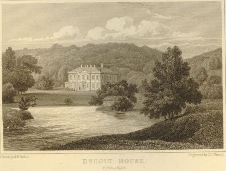
Mickle and his son returned in late April and Anna Maria noted ‘they thought your Papa had done much in his grounds since they were last here and thought the alterations beautiful’ (2 May 1804, ibid). In the following March, the stable yard was planted and on the Mickles’ (final?) visit in May 1806, the Cromptons declared that ‘he [Mickle] is much pleased with what we have done’ (4 May, ibid). The new more open designed landscape was drawn by JP Neale in 1811 (Figure 8).
Anne Lister was friends with Henrietta Matilda Crompton, daughter of Anna Maria and Joshua, and recorded in her diary on 11 June 1823 going to the end of the avenue: ‘about a mile past Apperley turned down a short bye road past a cottage on our left which led us into the Crompton’s approach — looked down through the vista upon the house (Esholt hall) 1/2 mile from us’ (WYASL SH:7/ML/E/7/0022). She visited the following 8 January, noting ‘we walked out in the grounds — the situation beautiful’ (WYASL SH:7/ML/E/7/0095). Henrietta Matilda’s sketches of Esholt Hall from 1824 held by the Bradford Museum (H.3/1985) showed the maturing landscape (Figures 9 & 10).
Later history
On inheriting the estate from his father in 1832, William Rookes Crompton Stansfield made changes to the hall by altering the west front. In the grounds his gardener, James Pringle, laid out a flower garden between 1833 and 1837 next to the kitchen garden (The Gardener’s Magazine 1841, 610-3) and an iron footbridge was added over the river just south of the stepping stones and weir (Leeds Intelligencer, 13 September 1834). These are shown on the 1st edition 6” OS map surveyed 1847/8 (Figure 9), together with the hothouse in the northwest corner of the kitchen garden. Between 1847 and 1860, the extant conservatory was added to the northeast section of the hall, as a party is recorded visiting it (Bradford Observer, 12 September 1861) and possibly the small formal garden to the east of the hall (Figure 12).
By this stage, the construction of nearby railways and other industry was starting to impinge on the rural setting of the estate. In 1861 after a railway line extension was put in against Stansfield’s wishes, he decided to move to Frimley Park in Surrey, where he died in 1871. William Crompton Stansfield inherited the estate from his uncle and he and his family moved into the hall. They continued to maintain the grounds with further glasshouses added to the kitchen garden (Figure 12). On William Stansfield’s death in 1888, it passed to his three daughters who were under pressure to sell to Bradford Corporation for a new sewerage works. They finally agreed to the compulsory purchase in early 1906 when they accepted a payment of £239,742 for the estate.
The planned sewerage works were to have a profound effect on the main designed landscape in Esholt (Figures 13 and 14) with parkland and views from the hall lost. The hall and its adjacent gardens were kept as they were used as offices, together with the northern woodland (Esholt Spring) and these remain in place today.
Location
Esholt Hall lies 4.5 miles (7km) northeast of Bradford and 3.5 miles (5km) south of Otley.
Area
The historic designed landscape at its greatest extent covered c. 260 acres (104 hectares).
Boundaries
The northern boundary is formed by the public road from Upper Esholt village in the west to Boggard House in the east before continuing along the northern edge of Spring Wood and Belmont Wood to SE 193 409. The eastern boundary follows the edge of Belmont Wood and Stone Top Wood until the public road from Otley at SE 191 401 and then follows it south to SE 192 395 before continuing along the eastern edge of the park and the Avenue to Apperley Lane. The western boundary goes north following the river Aire from SE 191 386 to SE 186 392 before following the western edge of the park to SE 186 396 and back along the river to SE 182 401.
Landform
The underlying bedrock covering Esholt Hall is quite complex. In the southern parkland it is Guiseley Grit sandstone with the northern parkland having Millstone Grit Group mudstone with a strip of Huddersfield White Rock sandstone. In the western part of Spring Wood it is Rough Rock sandstone with the rest Millstone Grit Group mudstone. The whole area is overlaid with superficial sedimentary deposits of mainly sand and gravel with some clay and silt near the river. All the ground has slowly permeable, seasonally wet, acid loamy and clayey soils with low fertility.
Setting
Esholt lies in the National Characterisation Area 38 (Nottinghamshire, Derbyshire and Yorkshire Coalfield) that is typified by the impact that industry has had on the landscape over the last 250 years. It is a generally low-lying area, with hills and escarpments above wide valleys and major rivers running through it. The nearby conurbations continue to spread into the remaining natural landscape. The hall sits at 62m AOD, slightly above the river to the south at 60m AOD, with the land rising slightly to the south at the start of the Avenue and along its route to reach a height of 66m OD at its southern extent. To the north of the hall, the ground rises steeply to 143m OD in Spring Wood and to the west to the plantation next to the village of Esholt at 74m OD.
Entrances and approaches
North Entrance
Off the public road from Nether Yeadon to Esholt village at SE 191 398, the carriageway went west before going through the gatepiers (Grade II – NHLE 1133191) north of the hall with another route to the stables.
Southern Entrance ‘The Avenue’
This was created before 1727 and was a route from Apperley Bridge in the south to the hall. At the top of the hill was a pair of gatepiers shown in the mid-18th century drawing (Figure 6), which are still extant (Grade II – NHLE 1133192)
Principal buildings
Esholt Hall [Grade II* - NHLE 1133190]
Built 1706-7 on site of former nunnery, with additions to west front c. 1832. North of the east front is a conservatory added between 1847 and 1861.
Stableblock [Grade II – NHLE 1133154]
Built c. 1727-30 with an extension on southern end later in 18th century.
Bridge [Grade II – NHLE 1314419]
Early 18th century built to take the carriageway from the Avenue over the beck to the hall.
Riverside Mill/Summerhouse [Grade II – NHLE 1133152]
The building was a fulling mill, whose origins may go back to the time of Esholt Priory. It was rebuilt as a single-storey L plan structure sometime after 1721, with the eastern block with its 3 rooms and fireplace as a summer house or gazebo and the south-west wing over the goit (water channel) possibly serving as a bath house.
Gardens and pleasure grounds
Hall gardens
The priory buildings had a ‘small orchard’ in 1539, described as ‘the Convent orchard lying without the said wall of the East side of the house and is well paled round about’ (Brown 1886, 322) that probably was on the site of the later kitchen garden. There was a second separate orchard that a later survey of 1612 (WYASL WYL500/854) said covered 2r 30p and adjacent ‘Horse Coppice’ of 1a 1r 17p, probably to the north and east of the buildings.
Within the walled area (or fold) by 1704 there was a ‘pheasant garden’, which was an enclosed area for keeping pheasants with a building to house them called a ‘pheasantry’. Although they had been introduced to Britain many centuries before and were a popular hunting bird for the Normans, they were in sharp decline by the late 17th century. Although there are later examples of pheasant gardens or grounds such as the one at Kew from 1757-62 (Figure 15), this appears to be an early example. It may be the small area with a building next to the southeast corner of the walled garden (Figure 1).
As the new hall had the same footprint as the old building, the overall layout was unchanged although new areas were made including formal parterre gardens to the south and east of the hall accessed by steps, a bowling green and small wilderness further east, together with a pond to attract swans (Figure 1). To the west a new orchard was added in the area known as the Holme. These formal gardens were still in place, with the possible exception of the wilderness by the late 1750s (Figure 6) but probably removed soon after and grassed over. The Swan pond was drained and the stream leading to it was diverted under the bowling green.
The gardener, James Pringle, laid out a flower garden between 1833 and 1837 next to the kitchen garden that he described in detail in The Gardener’s Magazine (1841, 610-3, Figure 16):
‘The ground is nearly on a level surface, with a slight inclination to the east, having a wall on the north side, 8ft high and 100 yards in length, against which are planted different varieties of China roses, and various creepers and half-hardy shrubs. On the east and west ends of the garden there is grass…to the extent of the wall, on which are planted hardy flowering shrubs…with early flowering bulbs, as crocus, snowdrop, narcissus [underneath].
All the walks are gravelled and the beds surrounded with box…Most of the beds have patches of bulbs, or low-growing early flowering plants…some may think that the beds would be crowded with plants, but such has not been the case, as the bulbs have chiefly done flowering before the herbaceous plants have made much growth, and the herbaceous plants are nearly over before the dahlias are in full bloom; which arrangement has insured a succession of flowers from the first fine weather in spring until the frosts kill the dahlias in autumn’.
Immediately to the east of the hall, a small formal garden with central pool and surrounded by conifers was put in after 1848 (Figure 12) and was painted by Henrietta Matilda Crompton (Figure 17).
Southern pleasure grounds
This was first laid out before c. 1720 between the walled enclosure around the hall and the public road in the former Westfield. It comprised of 4 acres that was described as ‘Westfield and the firs and Cleatty (?) Lady’s Walk’ next to the hall grounds and ‘Westfields the firs & walks in it’ of 3¼ acres, with a path linking the two areas. This was gradually thinned possibly during the landscaping done between 1801 and 1806, with a small fish pond added to the northwest. To the east and south of the hall there was further planting, again probably c. 1801-6.
Northern pleasure grounds
Developed after Sir Walter Calverley acquired the woodland, Esholt Spring, in 1719. Covering over 50 acres, the 1st edition OS 6” map, surveyed in 1847/8 (Figure 5) showed walks (including one labelled ‘Ladies Walk’), seats and a grotto but when these were put in is unknown.
Kitchen garden
In the early 18th century, this was immediately north of the hall and covered just under ½ acre. From a notebook held by the Aireborough Historical Society, there is reference to the gardener, Thomas Fleming, being paid £4 per annum with an additional 20s (£1) to buy seeds etc and John Swan, also employed as a butler, paid £4 to work in the gardens on 29 June 1717. By 8 August 1726 Thomas Johnson was the head gardener and he was paid £16 per annum also to purchase seeds, plants and to paint fences etc.
The original kitchen garden was expanded to incorporate the old orchard area to the east of it sometime before 1847 together with more land to the north, giving a total area of just over 1½ acres. There was a large freestanding glasshouse in the northwest corner of the walled section by 1847 and a further glasshouse was added to the north wall with free standing glazed structures in the northern section by 1890 (Figure 12).
Park and plantations
The Park
Created in the first decade of the 19th century, it covered about 150 acres at its greatest extent in the 1850s. Small sections remain to the south and west.
Westfield Plantation
Next to the village of Upper Esholt, this was in place by the mid 19th century but may well date from an earlier period. Covering c. 5.5 acres, it is extant.
Spring Wood/Belmont Wood/Stone Top Wood
This area of woodland dates back to at least the late 17th century and may be the ‘Spring Mabbe Wood’ mentioned as part of the lands of Esholt Priory in 1540. Covering c. 75 acres, it is extant and owned by Bradford Council with full public access.
Water
A small ‘swan pond’ was created c. 1720 southeast of the hall but was filled in probably in the remodelling of the 1800s. A large fishpond of just over an acre next to Spring Wood again c. 1720 has also been filled in following the construction of the sewerage works. A smaller pond of just under a ⅓ acre in the northern part of the parkland at SE 189 400, probably created in the early 19th century remains.
Books and articles
Bell, H. E. 1938. ‘Esholt Priory’. Yorkshire Archaeological Journal 33, 5-34
Brown, W. 1886. ‘Description of the Buildings of Twelve Small Yorkshire Priories at the Reformation, VIII – Esholt’. Yorkshire Archaeological Journal 9, 321-5.
Hunter, J. 1830. The diary of Ralph Thoresby, Volume II. London, Henry Colburn and Richard Bentley.
Margerison, S. ed. 1886. ‘Memorandum book of Sir Walter Calverley, Bart’. In Yorkshire Diaries and Autobiographies in the Seventeenth and Eighteenth Centuries. Durham, Surtees Society.
Neale, J. P. 1821. Views of the seats of noblemen and gentlemen, in England, Wales, Scotland, and Ireland, Volume 4. London, Sherwood Neely and Jones.
PRO 1905. Letters and Papers Henry VIII Vol 20, January -July 1545. London, HMSO
Slater, P. 1880. History of the Ancient Parish of Guiseley. London, Hamilton Adams & Co.
Primary sources
National Trust Collections (NTC)
582508 South Front of New Calverley near Leeds, seat of Sir Walter Calverley nd (c. 1720), https://www.nationaltrustcollections.org.uk/object/582508
North Yorkshire Archives (NYA)
ZCM William Rookes Crompton: letters from his mother & family 1802-1812
The National Archives (TNA)
PROB 11/1278/130 Will of Jane Stansfield of Esholt, 10 August 1796
West Yorkshire Archives Service, Bradford (WYASB)
23D98/1/11 Survey of Esholt cum Guiseley Manor, 1708 (1727)
23D98/1/12 Survey of Esholt cum Guiseley Manor, c. 1788
DB5/C8/14b Draft articles of agreement between Joseph Pape of Farnley, mason and Walter Calverley to pull down and rebuild Esholt Hall, 3 Sep 1708
West Yorkshire Archives Service, Leeds (WYASL)
SH:7/ML/E/7/0022 Anne Lister diary, 9 - 11 June 1823
SH:7/ML/E/7/0095 Anne Lister diary, 6 – 8 January 1824
WYL500/30 Lease from Henry VIII to William Knevet of the house and site of the late priory of Esholt with all appurtenances in Esholt, Guiseley and Otley, for 21 years, 20 Mar 1540
WYL500/31 Letters Patent of Edward VI to Henry Thompson of the late Priory of Esholt, 25 Aug 1547
WYL500/47 Articles of agreement between William Long and Timothy Overend and Sir Walter Calverley, to convey to Sir Walter Esholt Spring and Three Spring Plaines in Upper Esholt, 8 Jun 1719
WYL500/754 Articles of agreement between Sir Walter Blackett of Wallington and Robert Stansfield of Bradford, that Robert Stansfield should purchase the manors of Idle and Yeadon and all appurtenances in Esholt, Hawksworth, Yeadon, Guiseley, Idle and Shipley, 6 Jan 1755
WYL500/763 Bargain and sale from Sir Walter Blackett to Robert Stansfield of the manors of Esholt, Yeadon, Idle and Esholt Hall and other lands in Guiseley, Upper Esholt, Hawksworth and Shipley, 12 Feb 1756
WYL500/767 Mortgage by lease and release for £20,000 from Robert Stansfield to William Sitwell of Renishaw, Derbyshire, secured on the manors of Esholt, 11/12 February 1757
WYL500/854 Survey of lordship of Esholt by Robert Saxton, 1612
WYL500/860 Lease and release between John Baildon of Esholt and Walter Calverley, of a messuage in Esholt and lands there, 14-15 February 1699
WYL500/908 Probate of the will of Robert Stansfield of Esholt, 1772
Maps
Ordnance Survey 6” 1st edition, surveyed 1847-8, published 1851
Ordnance Survey 25” 1st edition, surveyed 1890-1, published 1893
Ordnance Survey 6” revised edition, revised 1934, published 1934
Figure 1 – Gardens around the hall c. 1720 based on drawing (NTC 582508). Ordnance Survey 6” 1st edition, surveyed 1847-8, published 1851. National Library of Scotland CC-BY.
Figure 2 – The Avenue from Apperley Lane to ‘Sweep’ south of the hall. Ordnance Survey 6” 1st edition, surveyed 1847-8, published 1851. National Library of Scotland CC-BY.
Figure 3 – Northern pleasure grounds in Westfield. Ordnance Survey 6” 1st edition, surveyed 1847-8, published 1851. National Library of Scotland CC-BY.
Figure 4 – Plantations and walks immediately north of hall c. 1720 based on drawing (NTC 582508).
Figure 5 – Spring Wood pleasure grounds with walks, seats and grotto. Ordnance Survey 6” 1st edition, surveyed 1847-8, published 1851. National Library of Scotland CC-BY.
Figure 6 – A View of the Estate at Esholt Hall, Yorkshire, undated by Samuel Scott. Yale Center for British Art, Paul Mellon Fund, B2009.5.8. Public domain.
Figure 7 – Esholt park and gardens. Ordnance Survey 6” 1st edition, surveyed 1847-8, published 1851. National Library of Scotland CC-BY.
Figure 8 – Esholt drawn in 1811 from J P Neale’s Views of the Seats, Mansions, Castles Volume V, Plate 36 (London, 1821). © The Trustees of the British Museum.
Figure 9 – Esholt Hall gardens and kitchen garden. Ordnance Survey 6” 1st edition, surveyed 1847-8, published 1851. National Library of Scotland CC-BY.
Figure 10 – View of hall and gardens, watercolour by Henrietta Matilda Crompton, nd. ‘Esholt Hall’ sketchbook, H.3/1985 © Bradford District Museums & Galleries CBMDC.
Figure 11 – View from library at Esholt Hall looking south to river and carriageway approach, watercolour by Henrietta Matilda Crompton, nd. ‘Esholt Hall’ sketchbook, H.3/1985 © Bradford District Museums & Galleries CBMDC.
Figure 12 – Esholt Hall gardens and kitchen garden. Ordnance Survey 25” 1st edition, surveyed 1890-1, published 1893. National Library of Scotland CC-BY.
Figure 13 – Proposed sewerage works at Esholt from Bradford Corporation 1912. Esholt sewage disposal scheme. Bradford Corporation.
Figure 14 – Esholt estate with sewerage works. Ordnance Survey 6” revised edition, revised 1934, published 1934
Figure 15 - Menagerie and pheasant garden, Leaf 40 in William Chambers album of drawings, ‘Plans, Elevations, Sections, and Perspective Views of the Gardens and Buildings of Kew’ by Thomas Sandby. Met Museum New York 25.19.40. Public domain.
Figure 16 – Flower garden at Esholt Hall from The Gardener’s Magazine (1841, 610-3).
Figure 17 – Formal garden in front of east section of hall, watercolour by Henrietta Matilda Crompton, nd. ‘Esholt Hall’ sketchbook, H.3/1985 © Bradford District Museums & Galleries CBMDC.
. Ordnance Survey 6” 1st edition, surveyed 1847-8, published 1851. National Library of Scotland CC-BY.")


.")


. © The Trustees of the British Museum.")


.")
