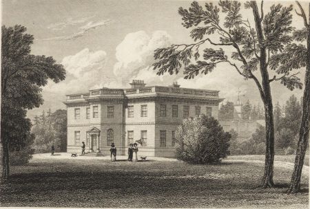
Although the Fawkes family had lived in Farnley since the 13th century, it was not until Walter Fawkes (né Hawksworth) inherited the estate in 1786 that the designed landscape we see today started to be put in place. Walter died four years later and his son, Walter junior, continued the major remodelling over the next twenty years. Walter was a patron and friend of the artist, JMW Turner, who documented the transformed landscape in a series of paintings that Fawkes proudly carried with him to London to show off his estate. Walter’s descendants have continued to maintain the designed landscape, so it still provides a suitable setting for the Grade I listed Farnley Hall.
Farnley had been part of the archbishop of York’s large estate and in the early 13th century, Fulk de Wakefield acquired half of the tenancy of the lordship or manor there. His descendants, the Fawkes family, maintained this landowning throughout the medieval period but by the late 16th century had started to acquire further land in Farnley. It was probably at this point that the older part of Farnley Hall was built. However it was not until Thomas Fawkes acquired the other half of the manor and further land there in 1686 that the grounds around the hall could be developed.
Throughout the 18th century, the Fawkes family continued to acquire neighbouring estates through purchase and marriage. The estates that Walter Hawksworth inherited from his distant relative, Francis Fawkes, along with his own, therefore gave him and his son substantial funds to carry out their plans for the hall and the landscape. This included creating a large park of over 270 acres to the south of the hall with two entrances from the east and west, a new kitchen garden covering 2.5 acres and a 16 acre lake encircled by plantations to the northeast. Walter’s son, Francis, expanded the park mainly to the east by 1848, almost doubling it in size to 500 acres. His nephew, Ayscough, made further changes in the 1870s, most notably moving the carriageways north of the hall. Although there was some tree felling and digging in the park to due army camps in the grounds in WW1 and WW2, today’s designed landscape remains largely unchanged.
Estate owners
Farnley was part of the extensive landowning of the Archbishop of York in the 11th century along with neighbouring settlements such as Otley (https://opendomesday.org/place/SE2148/farnley/, accessed 27 May 2026). Before 1238, half of the lordship of Farnley and lands there had been bought by Fulk de Wakefield from Richard de Wassand (Stanley Price 1955, 72). His descendants, the Fawkes family, retained these lands for the next four centuries. John Fawkes and his descendants started to play a more prominent role in Farnley from the late 15th century. His eldest grandson, John, died in 1556 and was succeeded his son, Richard and then his grandson, Thomas, in 1587.
Thomas Fawkes died without heirs in 1627 and the estate went to his cousin, Michael. On the latter’s death in 1647, his son, Thomas, inherited followed by his grandson, Francis, in 1707. Francis’ three sons, Thomas, Ayscough and Francis junior succeeded him in turn from 1747 to 1786. As none of them had surviving children, Francis devolved the Farnley estate to a distant relative, Walter Hawksworth, who changed his name to Fawkes. Walter died in 1792 and was succeeded by his son, Walter junior and then by his grandson, Francis, in 1825. Francis Fawkes had no direct heirs, so his nephew, Ayscough, inherited in 1871, followed briefly by his brother and then his nephew, Frederick, in 1900. Frederick and his brother, Walter, who succeeded him in 1936 also had no heirs, so it devolved to their nephew, Major Le G.G.W. Horton (later Horton-Fawkes), in 1943 and his descendants still own the estate.
Key owners responsible for major developments of the designed landscape and dates of their involvement:
Thomas Fawkes 1587 – 1627
Michael Fawkes 1627 – 47
Thomas Fawkes c. 1672 – 1707
Francis Fawkes 1707 – 47
Ayscough Fawkes 1751 – 71
Francis Fawkes 1771 – 86
Walter Fawkes senior (né Hawksworth) 1786 – 92
Walter Fawkes junior 1792 – 1825
Francis Fawkes 1825 – 71
Ayscough Fawkes 1871 – 99
Early history of the site
The Archbishop of York held Farnley prior to the Norman Conquest and in 1086, it remained part of the archbishop’s estate centred on Otley that had c. 4,000 acres of arable land and c. 3,600 acres of woodland (https://opendomesday.org/place/SE2148/farnley/, accessed 27 May 2026). In 1279 the Farnley lordship owned by the archbishop had 4 carucates of arable land (c. 480 acres) out of 16 carucates (c. 1920 acres) in total (Surtees Society 1867, 204). This equates to the size of the later civil parish indicating Farnley’s boundaries were probably unchanged from the medieval period.
The landholding of the archbishop’s tenants at this time was complex, with many also having interests in the neighbouring settlements of Newall, Lindley, Leathley and Pool. Half the lordship had been held by the ‘de Farnley’ family until the late 12th or early 13th century when it passed to Richard de Monte alto of Newall. His daughter married Adam de Wassand and their son, Richard, sold their half of the lordship and land at Farnley to Fulk de Wakefield before 1238 (Stanley Price 1955, 72). Fulk’s daughter, Alice, married William de Lindley in 1238/9 and her father and brother granted their interest in Farnley to the couple (ibid, 73). Their son, Fulk de Farnley, made an agreement before 1259 to exchange with Walter and Alice de Scoteny part of his demesne land in Farnley for the mill at Farnley (ibid, 72-3). In 1296, William Fawkes of Newall (son or possibly grandson of Fulk de Farnley) held half of the manor with lands in Farnley (ibid, 71). It remained with the Fawkes family throughout the medieval period.
Other lands at Farnley were held by the Lelay family of Leathley, with Robert de Lelay granting 2 bovates of land (c. 30a) in Farnley to Sallay [Salway] Abbey between 1199 and 1216 (YAS 1934, 84). Serlo of Pool gave 4a of land there c. 1173-7 to St Leonard’s Hospital in York from his holdings (Carpenter 2015, 200). By the end of the 15th century, the Lyndley [Lindley] family of Leathley held half the manor (or lordship) of Farnley (Lumb 1899, 182). A report on ‘the parcels of land of the abbot and convent of Sallay lying in the township of Farnley’ showed the individuals who had land next to those belonging to the abbey. Probably dating from the 1480s, it mentions Percival and William Lyndley, Richard Keighley [of Newall], the Earl of Northumberland, John Popley, John Fawkes, the archbishop of York and lands belonging to [Thomas?] Daid and [Edward?] Clapham (YAS 1934, 86-7). The abbey’s total landholding was a messuage, toft and 7½a of land that was split into 17 separate areas in the township.
During the 16th century, while the Fawkes family retained their lands passing them down the male line, the rest of Farnley was subject to changes in ownership. Thomas Lindley died in 1524 without a male heir, so his share of the manor and lands there went to his daughter, Isabel and her husband, Brian Palmes (Lumb 1899, 182). Palmes died five years later and his widow married Sir Thomas Johnson, who gave the Farnley estate to Isabel for her lifetime in his will. Following her death in 1550 her elder son, Francis Palmes, granted his share of the manor of Farnley to her younger son, Henry Johnson, the following year (TNA E 210/9765). Johnson though was arrested for treason in 1569 and his assets seized by the Crown that led to a long dispute over ownership, which was finally settled in Francis Palmes junior’s favour. These lands remained with the Palmes family until their acquisition by Thomas Fawkes in 1686. A survey of lands in the ‘manor of Farnley’ from 1588 (LUSC DD146/11/2/11) was probably the disputed area. The total of 154a 21p comprised of 4 large tenanted farmsteads with further land in the township’s fields, 5 cottages with small plots of land adjoining and other closes in Farnley.
The lands gifted to Sallay Abbey in Farnley were given to Sir Arthur Darcy in 1538, following the dissolution of the abbey (YAS MD335/6/68/1) and probably passed to Henry Johnson (TNA E 134/27). Those belonging to St Leonard’s Hospital were bought by Robert Moyse from Henry Clifford, Earl of Cumberland, in 1546 (Carpenter 2015, 272) and remained with his descendants until they were bought by Walter Fawkes in the late 18th century.
There are no records as to whether the Fawkes family had a manor house on the site of the hall in the medieval period. Once John Fawkes and his descendants are described as ‘of Farnley’ from the late 15th century, they were probably living there but nothing is known of their residence. The old part of Farnley Hall has been much altered over the last 200 years, including the addition of sections of other old buildings and thus it is difficult to do any accurate dating. It may date from as late as the early 17th century during the tenure of Thomas Fawkes, who died in 1627.
Thomas’ father, Richard, succeeded to the Farnley estate in 1556. He had married Margaret Johnson, daughter of Sir Thomas and Isabel (née Lindley), thus strengthening the family ties with the other major landholder in Farnley. During the time of the dispute between the Johnson and Palmes families with the Crown, he acquired further property there including land belonging to Nicholas Angrom in 1577 (https://www.british-history.ac.uk/feet-of-fines-yorks/vol2/pp98-112, accessed 30 July 2026) and two messuages, two cottages with land in 1580 from Nicholas Fawkes senior and junior, Thomas Hamlyn and Robert Pawson (https://www.british-history.ac.uk/feet-of-fines-yorks/vol2/pp146-160, accessed 30 July 2026). Richard Fawkes died in 1587 and his son, Thomas, continued to expand his share of lands at Farnley. In 1604, he and his tenants were judged to have enclosed 25a from common land and the king’s highway (LUSC DD146/11/2/11) that included erecting dwelling houses and a barn there.
Thomas Fawkes died without heirs in 1627 and the estate devolved to his second cousin, Michael Fawkes. He moved to Farnley from his estate in South Duffield but by 1646 had significant debts of £500 with his lands at Farnley valued at just over £118 a year in rental (Clay, 110-2). As his demesne lands were valued at 8s 4d an acre, his total estate (excluding any rights to common land) therefore was about 280 acres with tenants occupying just under half (ibid). The list of lands in the demesne of Farnley showed that these were spread throughout the township, which was typical of estates at that time:
Sandbed 19a
Ox Close 29a
Formbie 20a
Lady toft 12a
Long close and bean lands 20a
Sandbed head close 12a
Ware close 7a
Cow close 11a
Caradins 5a
Halifax Close 5a
Dubb close & 2 other closes 6a
Total 146a
Michael Fawkes died in 1647 and his widow, Mary, managed the estate for their young son, Thomas. The hearth tax for 1672 recorded Mary living at the Hall that had 15 hearths, which was a substantial building, with her son living at Arthington, one of their other properties. Whether Farnley Hall had been altered since the Civil War is not known although given her husband’s debts, it is probably unlikely. She did however continue to look after the estate for her son, including maintaining its boundaries, up until her death in 1672.
Chronological history of the designed landscape
1686 - 1785
In 1686, Thomas Fawkes became an MP and he acquired the remaining half of the manor of Farnley and also property in Lindley from William Palmes. This may have prompted him to develop his estate, including the hall and adjacent grounds, to reflect his new status. A survey and rental from 1699 (LUSC DD146/11/2/11) gave a list of tenanted lands and those in Thomas Fawkes’ hands listed below:
House, Orchard & Garden, Garth Wood and Cunny [Coney] Garth – Fawkes
Addlingley Croft – 3a
Stripe Calf Garths – 4a
Bustard Croft – 4a
Halifax Close – 7a
Middlefield and Long Close – 10a
Warnell Croft & 3 Swine Crofts – 24a
All [above] rich meadow – 52a
Middle Swine Croft – 4a is corn
Hall Close Bean Lands – 9a
Great Close & Great Middlefield – 22a with 4a Swine Croft
All [above] rich pasture – 35a
All in my own hands – 17 closes meadow and pasture in all £100
Total in closes – 91a
If ‘Great Close’ and ‘Great Middlefield’ were part of the later ‘Paddock’ and ‘Great Cow Close’, these closes of meadow and pasture were all in the area to the south of the hall leading to the river (Figure 1). By trying to consolidate this area of grasslands, he was perhaps trying to create a small park-like area on the southern approach to the hall from the river via a coach road. Samuel Buck’s sketch of c. 1720 (Hall 1979, 200-1) showed the hall with its service buildings and a walled court in front that would have been the main entrance from the coach road. In the southwest corner was a small building, possibly a banqueting house.
Thomas had died in 1707 and the estate had devolved to his son, Francis, although by the time of the survey below it may have been his eldest son, Thomas, who was resident. They had also acquired the neighbouring Hasling Hall estate from the Angrom family in 1728 that may have given them the land in the closes next to the hall that they did not own in 1699. A ‘Survey of demesne lands in my son’s hands’ from 1733 (LUSC DD161/11A/2) showed that these were now around the hall creating a more unified estate as seen in the later estate map (Figure 1).
Mansion house, yards, stables, barns, gardens & rookery – 4 a
Addingley Croft – 2a
Far Cow Close – 6a
Near Cow Close – 12a
Strip – 6a
Hall Close – 7a
Bean Lands – 7a
Paddock, now in 2 – 12a
Near Swines Croft – 8a
Middle Swines Croft – 4a
Far Swines Croft – 4a
Far Stone field – 7a
Middle Stone field – 6a
Near Stone field – 7a
Warnell Croft – 10a
Long Close or Bustard Croft – 6a
Middle field – 6a
Calf close – 6a
Halifax Close – 10a
Carr Ridings or little Halifax Close – 6a
Low Close or low Stone field – 6a
Fir close or Fern Croft – 2a
Grove – 1a
Total – 144a
The hall and surrounding grounds are shown in a drawing of c. 1781 (WYASW WYW2035/10/page 35, Figure 2), where the high walls of the former court have been removed. Thomas died without heirs in 1751 soon after his father, so Farnley went to his brother, Ayscough. On the latter’s death in 1771, his younger brother, Francis, inherited. Francis had married Christiana Wilkinson in 1733 and through the marriage, the estate at Newall to the west was added to the family landownings. Francis commissioned an estate map in 1777 (Figure 1, LUSC YAS/MS1193/3) that gives the first accurate account of the layout at Farnley. It also showed that there had been little change since the 1733 survey with the demesne land still divided into closes. There had though been some alterations immediately around the hall with the ‘grove’ to the west of 1a in 1733, now expanded to incorporate the former ‘Adderley Croft’ that covered 2a. Two small plantations had been added, one to the north of the public road and another north of the stableblock.
1786 – 1825
Francis Fawkes died on the 17 July 1786 and he left his estates including Farnley to his distant relative, Walter Hawksworth of Hawksworth Hall, on condition that he changed his name to Fawkes. While Walter Fawkes senior is most noted for the building of the new south wing, designed by John Carr, he also had major plans for the surrounding landscape. The layout of the gardens and immediate grounds with its small fields were now very old-fashioned. Whether he engaged one of the landscape designers of the time is not known but Adam Mickle junior may have been consulted. When writing about Skelton Castle, John Walker Ord quotes from a letter that was sent to him by a clergyman: ‘I well remember viewing their destruction [of Skelton Castle c. 1790-4]…The person he employed, and urged him on to the work of destruction, was a Mr. Mickle, whom I afterwards met at Farnley Hall’ (Ord 1846, 253). He could though have been referring to Farnley Hall near Leeds.
Fawkes’ plan for the wider landscape included a plantation of nearly 58 acres on the hill opposite to the hall, possibly to improve the view from the new wing. Located in Otley Chevin and next to the Caley Hall estate also owned by Fawkes, the woodland was 1.75 miles due south of Farnley hall and planted in 1787/8 (Plan of plantations by Jonathan Teal in April 1788, private collection). Next to the hall, nearly 136a of the former fields had been turned into a park with clumps of trees and a surrounding shelterbelt (Figure 3). It was in place by 1796 (LUSC DD161/11A/3) but may have been planned by Walter Fawkes senior before his death on 17 October 1792. On his epitaph in Otley parish church, it noted ‘he removed from his own family seat at Hawksworth AD1786 to Farnley Hall; which mansion he rebuilt and was proceeding to make other improvements’. It was probably at this time the garden building and enclosed area to the south was removed and a haha put in to separate the parkland from the pleasure grounds and hall. The former coach road that had led directly to the hall from the south was also taken out, with a shorter route via the public road from the north west (Figure 3). The icehouse and two fishponds had been added to the north of the road with an open area called the ‘Green’ to the south of the ponds (Figure 4).
His son, Walter junior, inherited and he clearly intended to carry on his father’s development of the Farnley estate. To enable this, on 14 May 1796 he had a private Act of Parliament passed for ‘certain detached parts of the settled estates of Walter Fawkes…to be sold, and for…the money arising…[for] the purchase of manors, or other hereditaments, lying nearer to and more convenient to be enjoyed with, the mansion house at Farnley Hall’ (TNA YHL/PO/PB/1/1796/36G3n206). His father had already bought the neighbouring estates at Leathley from the Moyse and Maude families c. 1789, consolidating the landholding to the east. In 1799, he commissioned a map of his estate based on the earlier survey that has later annotations showing changes that were planned (Figure 3). These included moving the public road further north and creating 2 new carriageways from the east and west, passing through the new park to the hall. To the east, near the river Washburn, a large lake was planned (Figure 5). Some of these changes had started by 1802, as noted in a sketch (Figure 6)by John Claudius Loudon (1806, Plate XXII & 647-8), most notably the western carriageway from Otley and the extension of the parkland with its associated shelterbelts. A new carriageway is also shown from the east cutting across the main parkland and going to the west of the hall.
Loudon says that it was laid out by a ‘modern landscape designer’ although their identity is unknown. Walter Fawkes had engaged as a (head) gardener, Richard Cowburn, in 1802. Cowburn had set up a nursery business in Leeds and in an advert in 1793, described himself as understanding ‘the laying out of new Gardens, Pleasure Grounds and Plantations, and will do the above Work for any Gentlemen for the Season, to find Men and Trees, upon reasonable terms’ (Leeds Intelligencer, 11 November). Whether this involved the design of the grounds is not clear. It is likely that he was responsible for the layout of the new kitchen garden to the west including a hothouse, operational by 1804 as the bill for coals for it was paid on the 4 April (Estate accounts, Nov 1803 - Jan 1805, private collection).
The estate accounts (ibid) also record the construction of a bath house, although the location is uncertain:
17-19 Nov 1803 Paid Richard Murgatroyd for plasterers work in the new Bath, £6 5s; Paid Michael Johnson for leading [carrying] flag[stone]s for the new Bath, £1 4s
5 May 1804 Paid Colburn the glazier the balance of his bills for work and materials for the new Bath, £4 16s 5d
3 Sep 1804 Paid John Colburn's bill for additional work at the new Bath, £4 13s 10d
12 Sep 1804 Paid Joshua Cawood for nails & iron work chiefly for the new Bath, £4 5s 10d
There is no mention though of work on the lake and the new plantations around it. The weekly bills for ‘Farnley labourers’ give no specific detail and they would have employed around the estate. Between 4 November 1803 and 26 January 1805, their cost though amounted to £867 with a further £115 spent on the ‘Woods and Plantations account’(ibid), indicating significant activity.
John C. Loudon appeared to have been consulted in 1805, showing his plan for changes to the parkland in a sketch (Figure 7; 1806, Plate XXIII). Whether he was called in by Fawkes directly or was trying to get a commission, his ideas for planting in the parkland were not implemented. However he may have prompted the re-routing of the eastern carriageway away from the main parkland to its eastern side as noted on the 1799 map (Figure 3). Cowburn remained in post until about 1811, when he set up as ‘Nursery and Seedsmen and Contract Planters’ with his sons and supplied Joseph Rogerson with trees (Crump 1931, 127-8). He rented land from the Farnley estate as the nursery was based at the former kitchen garden of Newall Old Hall, with the stock of forest trees were being grown on north side of Otley Chevin (Leeds Mercury, 6 November 1813). It is therefore possible he continued to work for Fawkes as a contractor until 1822 when he and his sons moved to Market Place in Otley (Leeds Mercury, 2 March).
A map of Yorkshire surveyed between 1815 and 1817 (Figure 8) showed the new lake, extended parkland, new carriageways and their associated lodges. Many of these features, together with the boathouse and summerhouses on the edge of the lake and on hill above the river Washburn, were painted by JMW Turner. He was a frequent visitor to Farnley from 1808 (Bailey 2024, 144), with most of the sketches and completed paintings of the Farnley landscape dated to between 1815 and 1818. Walter Fawkes had commissioned Turner to make specific views of the hall and estate that showed it being enjoyed by visitors and these watercolours were taken to London by Fawkes to show his friends (ibid, 94-5). This suggests that the changes may have only recently been completed when the map was made.
There were further changes to the hall and immediate surroundings when old built parts from other Fawkes’ properties were transferred to Farnley in 1814 including a gateway (Figure 9) and a porch (Figure 10) both in the ‘flower garden’, part of the pleasure grounds to the east of the hall. Not all visitors were impressed though with the new designed landscape with Anne Lister noting in her diary on 11 June 1823: ‘Farnley-hall (Mr. Fawkes) to the north east about 1 1/2 mile from Otley. — but, as we observed in descending the Chevin the ground in front of the house is too much spotted with trees — the clumps remind me of so many queencakes (WYASC SH:7/ML/E/7/0022).
Later history
With the death of Walter Fawkes in 1825, his son, Francis, inherited the estate and continued to develop the designed landscape. By 1848, the parkland and Otley Plantation to the west had been expanded as far as Farnley Lane. A new area called ‘East Park’ had been added to the boundary with Leathley (Figure 11) with an extension of the carriageway to Wharfe Lane. To the north of the hall, a new lodge had been built following the move of the public road to the north. Francis died without a direct heir and so Farnley devolved to his nephew, Ayscough Fawkes, in 1871.
By 1875, the two carriageways from the east and west lodges had been moved away from the front of the hall and diverted to the north through the former flower garden that had been removed (Figure 12). Leathley Lodge was built close to the Leathley bridge marking the start of the carriageway through East Park and onto the hall of nearly 1¼ miles. The grounds immediately around the hall had been remodelled with a terraced area around the south front and with steps leading later to a central octagon pool and fountain. Another pond had been added to link up with the existing two between the hall and northern lodge. A new house for the gardeners was built to the northwest of the walled garden with more glasshouses and frames added.
Ayscough Fawkes died in 1899 and initially his brother, Frederick, succeeded but following his death a year later, it was his son, also Frederick, who inherited the Farnley estate. In 1914, a temporary tented army camp was set up in the grounds, followed by a more permanent base with wooden huts and training trenches throughout WW1 (https://otleylocalhistorybulletin.wordpress.com/2017/06/28/farnley-camp/, consulted 29 July 2026). They have left little trace on the ground as the trenches were filled in and land returned to its pre-war state. However there was a significant loss of woodland in the ‘Wilderness’ from the East Lodge to the stableblock. Of greater impact to the designed landscape was the army camp in WW2 in the western part of the park and in Otley Plantation. In addition new housing at Newall was affecting the surroundings of the western lodges and associated carriageway (Figure 13).
In 1936 Frederick Fawkes died and his heir and brother, Walter, decided that his nephew, Major Horton (later Horton-Fawkes) should take up residence (Bath Chronicle and Weekly Gazette, 31 July 1937). By 1962/3, much of the site of former camp had been planted and Wilderness replanted (Figure 14). With the exception of further housing in Otley Plantation next to Newall, the remainder of Farnley’s historic designed landscape remains intact continuing to provide a suitable setting for Farnley Hall.
Location
Farnley Hall is located just over 1.25 miles (2.25km) northeast of Otley.
Area
The historic designed landscape of Farnley Hall at its greatest extent in the early 20th century covered c. 730 acres (296 ha).
Boundaries
The southern boundary starts at Otley Lodge in the west and follows the southern extent of Otley Plantation to SE 208 461 when it reaches the river Wharfe. It then continues along the river until the point it meets the river Washburn. The eastern boundary is formed by the river Washburn to SE 229 468 when it goes north along Eland Wood to SE 229 471 and rejoins the river to SE 230 477. The northern boundary starts at the river Washburn in the east and follows the northern edge of the Lake Plantation to SE 220 473 when it reaches the public road. The latter continues west to Farnley Lane that forms the western boundary.
Landform
The underlying bedrock covering all of the Farnley Hall estate is the Millstone Grit Group of sandstone, siltstone and mudstone, which is overlaid with superficial sedimentary deposits of gravel within a mix of sand, silt and clay. Most of the estate has slowly permeable, seasonally wet slightly acid loam and clay soils with moderate fertility and impeded drainage. However the area next to the river Wharfe (‘Sandbed’) is freely draining loam.
Setting
Farnley lies in the National Characterisation Area 22 of the Pennine Dales Fringe, a varied landscape of high moorland fringes and plateaus dropping to the numerous river valleys, with the latter having the more fertile soils for farming. The hall sits at 126m AOD with the land falling away to the south and the river at 49m OD and rising to the north to the public road at 141m OD. To the east of the hall, the ground falls through East Park to river Washburn at 63m to 46m OD.
Entrances and approaches
Northern entrance – Farnley Lodge [Grade II – NHLE 1295831]
The lodge is mid-19th century with nearby gates and gate-piers (Grade II – NHLE 1315551) from the 18th century. A carriageway from it leads south to hall with further 18th century gate-piers c. 120m northeast of Farnley Hall (Grade II – NHLE 1315570) and 50 metres from hall (Grade II – NHLE 1174365), the latter probably from Hawksworth Hall and erected in 19th century.
East Lodges [Grade II – NHLE 1295802]
These are early 19th century and reputedly designed by JMW Turner sometime after 1808, together with gates, gate-piers and railings. From here, a carriageway leads west to the hall, initially to the south front but later was diverted to the north.
Leathley Lodge [Grade II – NHLE 1150009]
This was built possibly in the 1870s but before 1888. The carriageway from here then goes through East Park over Leathley Bridge (Grade II – NHLE 1150039) to the East Lodges.
West Lodge and Otley Lodge [Grade II – NHLE 1390978]
These are late 18th century, possibly by John Carr. Both have sandstone coats of arms of the Fawkes family dated 1618 on their walls, which are thought to have either been recycled from other buildings or made at the time of construction. On the left is West Lodge that has been extended in 20th century and on the right is Otley Lodge, which is its original size. The carriageway from here goes east to the hall and was painted by Turner c. 1818 (Figure 15; Finberg 1912, Plate XXVIII).
Principal buildings
Farnley Hall [Grade I – NHLE 1150040]
Dating from the 17th century or possibly late 16th century, the older north part of the hall was remodelled first by Walter Fawkes senior and his son (Country Life 20 May 1954, 1619) with further changes in the 1870s. The south front was added in 1786-90 to designs by John Carr.
Stables [Grade II – NHLE 1149998]
These are 50 metres east of Farnley Hall. These were built before 1777 with remodelling, possibly by John Carr, in the late 1780s.
Outbuilding [Grade II – NHLE 1149997]
30 metres north of Farnley Hall, this early 17th century building was removed from Newall Old Hall in the later 19th century.
Archway [Grade II – NHLE 1295804]
10 metres north of Farnley Hall and marked 1624, this originally was removed from Newall Old Hall in 1814 as part of the flower garden (Figure 10)
Icehouse
Built between 1777 and 1796, it lies to the 100m north of the hall and is extant.
Bathhouse
Constructed in 1803-4, its location is not known however, it may be the building 140m north of the hall (Figure 16). It may have been taken down during WW1, as it is not shown on the Ordnance Survey 25” map surveyed in 1919.
Boathouse
Located at the southern tip of the lake, this was painted by Turner c. 1818 (Bailey 2024, Figure 1.41).
Garden building (‘Pheasant’s Nest’)
Located next to the River Washburn, this was painted by Turner c. 1816 in a woodland setting by the bend in the river (https://www.tate.org.uk/art/research-publications/jmw-turner/joseph-mallord-william-turner-the-pheasants-nest-on-the-river-washburn-near-farnley-hall-r1146607, consulted 31 August 2026, Figure 17), so likely to be at SE 229 477. Its date of construction is uncertain but could be prior to the formation of lake as in an area of woodland shown on 1777 map. It is not marked on 1849 estate map or the 1st edition 6” Ordnance Survey map, surveyed in 1847/8.
Summerhouse (‘Moss House’)
At SE 228 476 and was in place by c. 1818, when painted by Turner (Bailey 2024, Figure 1.41). It was marked on the 1875 estate map but not on 1st edition 25” Ordnance Survey map, surveyed in 1888.
Gardens and pleasure grounds
The gardens around the 17th century hall shown in Buck’s sketch of c. 1720 (Hall 1979, 200-1) give little detail apart from the walled court to the south with its garden building in the southwest corner, although the western section may have been planted as a parterre. By 1777 (Figure 1), there was a further walled area to the west that may have been the kitchen garden, as it appears to be divided into four. To the north are rows of trees that may have been an orchard. The drawing from c. 1781 (Figure 2) shows that the ground immediately west of the hall was terraced, next to a walled section with two access doors, probably to the orchard.
Further west was the ‘Grove’ that had been 1a in 1733 but had expanded to 3a by 1777. To the north of the stables was a small planted area of trees and shrubs. By 1796, all parts of the formal garden had been removed, together with part of the Grove, for the new coach road from the west (Figure 4). There was also more planting to the east of the stables with an open area to the north of the public road called the ‘Green’.
With the move of the public road to the north, this area had been remodelled by c. 1814 (Figure 18). A ‘flower garden’ was created between the hall and the stableblock with an entrance taken from Menston Hall (Figure9). This would have had flowering perennials and shrubs that were becoming popular again due to the influence of Humphry Repton and these can be seen in an etching from a painting by Turner (Figure 19). The former open area of the ‘Green’ had now been planted by 1849, with further plantations to the west. The re-routing of the carriage drive to the north of the hall and new access road meant that the flower garden and its buildings had been removed by 1875 (Figure 12). At the same time, a new terraced area was built around the hall entrance to the east and at the south front, there were steps leading to a small area planted with evergreens (yews?) with a pond and fountain (Figure 16).
Kitchen garden
Prior to the construction of the extant kitchen garden c. 1802, there was one next to the hall, probably to the west of the main court area. With the latter’s removal between 1786 and 1796, it is not clear whether it was immediately replaced as there is no reference to a (kitchen) garden in the 1796 survey nor on the accompanying map of 1799. Fruit and vegetables for the hall may well have been supplied from one of the other properties that Fawkes owned such as Hawksworth Hall. The new site 500m west of the hall was probably laid out by Richard Cowburn, a local nurseryman and contract planter, who was paid £70 p.a. (Estate accounts, 1803-5). His obvious skill was noted in 1803, when the Hull Packet recorded on 11 January that he had ‘cut out 160 asparagus, a dish of kidney beans, a quantity of new potatoes, and a brace and a half of pine apples, all in high perfection and great maturity for the season’.
The main walled area covered 1.5 acres with a hothouse on the northern wall and to the south, was a further walled section of 1a that also had a greenhouse and flower beds in the centre by 1849 (Figure 20). A painting by Turner described as ‘The Conservatory’ c. 1818 has been the subject of some debate as to whether it depicted a real or imagined building as the stained glass window remained in the drawing room of the hall during Walter Fawkes’ lifetime (https://www.sothebys.com/en/buy/auction/2026/master-works-on-paper-from-five-centuries-2/the-glasshouse-with-armorial-window-farnley-hall, consulted 3 August 2026). However it is possible it did show the interior of the hothouse, built c. 1803-4, because in 1808 there was a bill for painting ‘flower stands’ (LUSC DD146/5/1/11) and the painting shows these.
By 1875, the southern glasshouse had been expanded with two new small glasshouses built to the west of the northern structure (Figure 16). To the northwest, a new ‘Gardens House’ had been constructed for the gardeners and frames added to the north of the walled area by 1888. The walls remain of the garden but the interior is now the gardens of the private houses of the converted bothy.
Park and plantations
Farnley Park
This was created between 1786 and 1796 and initially covered 136 acres immediately south of the hall (Figure 3). By 1805, it had expanded south and west to the river and east as far as Hasling Hall, an area of c. 270 acres. With the addition of East Park and further parkland next to Farnley Lane in the west by 1848, the park reached its greatest extent at just over 500 acres.
Otley Plantation
Formed between 1805 and c. 1817, it stretched from Otley Lodge in the south via the new kitchen garden to the grounds west of the hall in the north, with the new coach road running through it. It covered just over 92 acres. About 18 acres to the southwest is now covered by housing and a section to the northeast was cleared during WW2 but has since been replanted. There was further planting to the south of the former parkland that was also part of the army camp.
Wilderness
The first section north of the stables was planted before 1777 and had expanded east by 1796 to cover about an acre. By 1848, it reached the East Lodges and like the Otley Plantation, surrounded the new coach road. Nearly 19 acres at its greatest extent, it was reduced significantly by 1919 with over half of the area felled. It has since been largely replanted with just an area of c. 5.5 acres next to the public road.
Lake Plantation
Created around the lake largely c. 1802 to 1815, the eastern part next to the river Washburn was planted prior to 1777. From the public road through Whinney Gill to the river, it measured over 45 acres and remains extant although the woodland has encroached on the lake.
Water
Farnley Lake ‘Lake Tiney or Tiny’
In place by c. 1815, it may well have been planned and executed from 1802 (Figure 21). It covered nearly 16 acres with three small islands in the southern section. The two smaller islands near the western shore had gone by 1875 with one to the north of them added. While the lake remains extant, the growth of vegetation around the perimeter has reduced the area with water.
Fishponds
Two fishponds measuring 23p and 1r 8p were created north of the stables between 1786 and 1796, possibly to provide ice for the nearby icehouse. A third one was added after 1849 to the west and linked to original western pond (Figure 18).
Blakey Pond
Located in the northeast part of the Wilderness, this covered just over ¼ acre in 1796. It was shown on the 1777 map near a group of cottages, so probably constructed to serve as a water source for them. When this area became part of the designed landscape, it was incorporated into the eastern pleasure grounds.
Books and articles
Bailey, L. A. 2024. Walter Fawkes, 1769 – 1825 Patron of the Arts. PhD thesis, University of Glasgow.
Carpenter, D. X. ed. 2015. The cartulary of St Leonard's Hospital, York. Woodbridge, Yorkshire Archaeological Society and Borthwick Institute for Archives in association with The Boydell Press.
Clay, J. W. 1895. Yorkshire Royalist composition papers, Vol II. YAS Record Series, Vol. XVIII. Leeds, Yorkshire Archaeological Society.
Crump, W. B. ed. 1931. Leeds Woollen Industry, 1780-1820. Leeds, The Thoresby Society.
Finberg, A. J. 1912. Turner’s Water-colours at Farnley Hall. London, The Studio
Hall, I. 1979. Samuel Buck’s Yorkshire Sketchbook. Wakefield, Wakefield Historical Publications.
Loudon, J. C. 1806. Treatise on Forming Improving, and Managing Country Residences Volume 2. London, Longman Hurst Rees and Orme.
Lumb, G. D. 1899. ‘Testamenta Leodiensia, 1521-1526’ The Publications of the Thoresby Society, Volume IX, 161-92.
Ord, J. W. 1846. The History and Antiquities of Cleveland. London, Simpkin and Marshall.
Stanley Price, M.J. ed. 1955. Yorkshire Deeds Vol. X. Leeds, Yorkshire Archaeological Society.
Surtees Society 1867. The survey of the county of York. Durham, Andrews & Co.
YAS 1934. The chartulary of the Cistercian abbey of St Mary of Sallay, Vol II. Leeds, Yorkshire Archaeological Society.
Primary sources
Leeds University Special Collections (LUSC)
DD146/5/1/11 Misc estate bills for Farnley, 1786-1808
DD146/11/2/11 Survey of lands in Leathley and Farnley manors, 1588; Enclosures at Farnley on common land and highways by Mr Fawkes and his tenants, 1604; Survey and rental of lands at Farnley owned by Thomas Fawkes, 1699
DD161/11A/2 Survey of demesne lands at Farnley belonging to Francis Fawkes and his son, 1733
DD161/11A/3 Survey book of the estates at Farnley, Newhall with Clifton, Weardley, Arthington and Guiseley, made by Jonathan Teal, 1796
MD335/6/68/1 Crown confirmation of grant to Sir Arthur D'arcy of Sawley Abbey with all its lands including Farnley, 9 May 1538
YAS/MS1193/3 Plan of Farnley for Francis Fawkes by I. Bainbridge, 1777
Private Collection
A Plan of the estate of Walter Fawkes in the manor of Farnley by Jonathan Teal, 1799
Plan of an estate in the townships of Farnley the property of F. Hawksworth Fawkes by Robert Horsman, 1849
Plan of an estate in the townships of Farnley the property of Ayscough Fawkes, 1875
Account Book of John Smith for the Farnley estate, November 1803 - January 1805
The National Archives (TNA)
E 134/27 Lawrence Broadbent versus Henry and Thomas Curryer, right and title to lands in Farnley-in-Wharfedale, parcel of the late monastery of Sawley, whether formerly in the possession of Henry Johnson and of Sir Henry Darcy, 1585
E 210/9765 Francis Palmes and Thomas Horde to Henry Johnson grant of the manor of Farnley, 5 Edward VI (1551/2)
YHL/PO/PB/1/1796/36G3n206 An Act for vesting certain Parts of the settled Estates of Walter Fawkes Esquire, 1796
West Yorkshire Archives Service Calderdale (WYASC)
SH:7/ML/E/7/0022 Diary of Anne Lister, 11 June 1823
West Yorkshire Archives Service Wakefield (WYASW)
WYW2035/10/page 35 Aquatint drawing of Farnley Hall by R. F. c. 1781 (Wakefield Permanent Art Collection (The Hepworth Wakefield) on long loan to West Yorkshire Archive Service. Gifted by Frank Green, 1930. Ref. WAKGM:A1.91 10/35)
Maps
Map of the County of Yorkshire by Christopher Greenwood, surveyed 1815-7, published 4 June 1817 (David Rumsey Map Collection, ref. 16073)
Ordnance Survey 6” 1st edition, surveyed 1847 to 1848, published 1851
Ordnance Survey 25” 1st edition, surveyed 1888, published 1891
Ordnance Survey 25” revised edition, revised 1919, published 1921
Ordnance Survey 1:10,650 edition, revised 1930-45, published 1956
Ordnance Survey 1:2500 edition, revised 1962, published 1964
My thanks to Guy Fawkes of Farnley Hall and Paul Wood and S. Riches of the Otley Local History Bulletin for their invaluable information and help with this report.
Figure 1 – Estate map of Farnley, 1777 with annotations on areas in 1699 survey. Reproduced with the permission of Cultural Collections and Galleries, University of Leeds Libraries (https://explore.library.leeds.ac.uk/special-collections-explore/462292)
Figure 2 – Aquatint drawing of Farnley Hall by R. F. c. 1781. Wakefield Permanent Art Collection (The Hepworth Wakefield) on long loan to West Yorkshire Archive Service. Gifted by Frank Green, 1930. Ref. WAKGM:A1.91 10/35.
Figure 3 – Estate map of 1799 based on survey of 1796 by Jonathan Teal (private collection)
Figure 4 – Detail of icehouse and ponds on estate map of 1799 based on survey of 1796 by Jonathan Teal (private collection)
Figure 5 – Lake Tiney (Tiny) on the Ordnance Survey 6” 1st edition, surveyed 1847 to 1848, published 1851 (National Library of Scotland CC-BY) and marked in pencil on 1799 estate map (private collection)
Figure 6 – Farnley Hall in 1805 in Loudon, J. C. 1806. Treatise on Forming Improving, and Managing Country Residences Volume 2 (Public Domain)
Figure 7 – Proposal for Farnley Hall in Loudon, J. C. 1806. Treatise on Forming Improving, and Managing Country Residences Volume 2 (Public Domain)
Figure 8 – Park and lake at Farnley on Map of the County of Yorkshire by Christopher Greenwood, surveyed 1815-7, published 4 June 1817 (David Rumsey Map Collection, ref. 16073)
Figure 9 – Entrance to the Flower Garden at Farnley, print from painting by Turner. Yale Center for British Art, B1977.14.6577 (Public Domain).
Figure 10 – Porch in Flower Garden at Farnley, print from painting by Turner. Yale Center for British Art, B1977.14.6576 (Public Domain).
Figure 11 – Farnley Hall parkland, lake and plantations on the Ordnance Survey 6” 1st edition, surveyed 1847 to 1848, published 1851 (National Library of Scotland CC-BY)
Figure 12 – Farnley and immediate grounds on the 1875 estate map (private collection)
Figure 13 – Farnley park showing WW2 army camp on Ordnance Survey 1:10,650 edition, revised 1930-45, published 1956 (National Library of Scotland CC-BY)
Figure 14 – Replanting of park and Otley Plantation on Ordnance Survey 1:2500 edition, revised 1962, published 1964 (National Library of Scotland CC-BY)
Figure 15 – Carriage drive from Otley, print of painting by Turner c. 1818 from Finberg, A. J. 1912. Turner’s Water-colours at Farnley Hall, Plate XXVII (Public Domain)
Figure 16 – Farnley Hall ponds, pleasure grounds and kitchen garden on Ordnance Survey 25” 1st edition, surveyed 1888, published 1891. (National Library of Scotland CC-BY)
Figure 17 – Print of painting by Turner of ‘The Pheasant’s Nest’ Yale Center for British Art, B1977.14.14106 (Public Domain).
Figure 18 – Farnley Hall flower garden and immediate pleasure grounds on estate map of 1849 (private collection)
Figure 19 – Part of the planting of the Flower Garden in a print of a painting by Turner, Yale Center for British Art, B1977.14. 6578 (Public Domain).
Figure 20 – Kitchen garden at Farnley on estate map of 1849 (private collection)
Figure 21 – ‘Lake Tiny, Farnley, with Almias Cliff in distance’, print of painting by Turner c. 1818 from Finberg, A. J. 1912. Turner’s Water-colours at Farnley Hall, Plate XXX (Public Domain)


