The designed landscape at Healaugh Park and Manor has three distinct phases of development spanning the thirteenth to eighteenth centuries. The medieval deer park, Healaugh Park, was established prior to 1217 and it evolved and changed through to the post medieval period and was still in use until at least 1707. A small moated enclosure, containing the remains of a building, with sixteenth century pottery finds, may have been a hunting lodge, associated with the deer park.
Within the park lay the site of an Augustinian priory, Healaugh Park Priory, which has evidence of a surrounding precinct wall that may have enclosed gardens. Following the Dissolution of the monasteries the priory buildings were converted to an Elizabethan manor house, Healaugh Manor (Figure 1). During this second phase of development the house was surrounded by orchards and gardens contained within an ornamental moat. The wider deer park was also reshaped at this time to create a smaller parkland enclosed by a park pale bank and ditch. The third phase in the late seventeenth century saw the creation of more elaborate garden features, as an axial walk and tree avenue, terminating in a half-moon, were laid out. New orchards and lodges enhanced the surrounding small parkland, Knitter Park.
The Wharton family were lords of the manor of Healaugh from the mid sixteenth to early eighteenth centuries and then the Brooksbank family owned the estate till the mid twentieth centuries. Parts of the demolished priory and manor house survive incorporated within a complex of later farm buildings, Healaugh Manor Farm, some of which are listed Grade II and II*. Excavation and geophysical survey has revealed buried remains of buildings and structures with depths of undisturbed deposits, which may have potential for preserving elements of the medieval monastic garden and Elizabethan garden.
Estate owners
Following the dissolution of the monasteries the lands at Healaugh Park, held by the canons of Healaugh Park Priory, came into the possession of the Wharton family in 1540 who owned it till 1711, when the land was sold to the Brooksbank family, who retained it until 1961. The Whartons were minor gentry who were raised to the peerage for services to the Crown as followers of Henry VIII and the Earl of Northumberland. They acquired numerous estates and gained wealth through advantageous marriages and profitable lead mines in North Yorkshire. They held political influence and power and the family history is well documented (Dale 1906). The Brooksbank family were prosperous merchants and bankers, also wealthy landowners in Yorkshire and London (Seals 1969).
In 1528 Sir Thomas Wharton, Lord Wharton and First Baron (b1495 - d1568) was appointed by Henry Percy, 5th Earl of Northumberland, comptroller of his household and steward of the lordships of Healaugh and Tadcaster in the West Riding of Yorkshire, offices which Wharton held for life. He was also made Visitor of the Monasteries in the northern counties and Commissioner for the Discontinuance of Chantries and Mass chapels, which led to him acquiring former monastic lands across the north of England. He bought the manor of Healaugh and Catterton in 1531, leased Healaugh Park Priory and its demesne lands by 1536 and purchased the church tithes and advowson by 1541.
Thomas Wharton’s main residence was at Wharton Hall, near Kirby Stephen, where he added to the buildings and created a deer park by 1560. His first wife Eleanor was daughter of Sir Bryan Stapleton, who owned, amongst others, the manor of Wighill adjacent to Healaugh manor. Thomas constructed the Elizabethan manor house on the site of the Healaugh Park Priory, incorporating parts of the medieval buildings. A small garden and orchard lay adjacent to the house within the moat, which was set within enclosed parkland. In later years he resided there with his second wife Anne Talbot, who survived him and continued to live there till her death in 1584. She and Thomas are buried at St John the Baptist Church, Healaugh. The contents of the house were listed in an inventory following Thomas’ death in 1568 (Evans 1945, 134-150). The large numbers of tapestries, carpets and embroidered chair covers listed are a measure of his wealth and high status in society (White 2005, pp. 81, 100, 102, 136 & 137).
The next four generations of the Wharton family occasionally lived at Healaugh and had their main residences elsewhere. However, the house and its associated deer park were presumably a status symbol for the family where they entertained guests. Other family members, cousins Humphrey Wharton of Gillingwood and Henry Wharton managed the estate during their absence.
Philip, third Lord and Baron (b1555 - d1625) lived at Canon Row. He married Lady Frances Clifford, daughter of Henry Clifford, the Earl of Cumberland. Philip did reside at Healaugh at times, as shown by the birth of two of his children there. We also have household expenses for 1585 for supplies of food and wine at Healaugh between the months of May to October, where he entertained guests, such as Lord Rutland (Trevelyan 1832, pp. 224-242). He entertained King James I in 1617, at other family properties, which nearly bankrupted him. Philip is also buried at Healaugh Church.
Philip, fourth Lord Wharton (b1613 - d1696) lived at Aske Hall, but from 1643 his principal residence was Upper Wichenden, near Aylesbury, Buckinghamshire until 1658, when he moved to Wooburn. His finances and estates increased through favourable marriages to first Elizabeth, daughter of Sir Rowland Wandesford and then Jane Godwin. He occasionally visited his numerous Yorkshire estates. He mortgaged Healaugh to raise funds for improvements at Wooburn. Reverend John Gunter was employed as steward to run them and lived at Healaugh. Gunter died in 1688 and is buried in the Wharton vault at Healaugh Church (Dale 1909, 63). Cornelius Todd, who like Gunter, was a nonconformist ejected minister, was also allowed to live at the manor house at Healaugh Park (ibid. 154).
The manor of Healaugh was settled on Thomas, fifth Lord Wharton (b1648 - d1715) on his marriage to Anne Lee in 1673. Upon his father’s death in 1696 he inherited Wichenden and subsequently improved and rebuilt it. He also inherited Wooburn and carried out work on the grounds there. On acquiring Healaugh in 1673 and before 1696 when Thomas acquired the estates in Buckinghamshire, it is likely that he developed Healaugh Park and laid out ornamental gardens and created a small parkland, Knitter Park, within the wider deer park.
The Brooksbank family then bought the manor of Healaugh and owned the land until 1961. Joseph Brooksbank (b1654 - d1726), a prosperous London merchant, first leased Healaugh in 1711 and then purchased it in 1714 for £9,495, to provide funds to Lord Wharton. Joseph built a new house, locating it in a more pleasant elevated position in Healaugh village, adjacent to the former manor house site of Hall Garth, in contrast to the lower lying house site within Healaugh Park, which then became known as ‘Old Manor’. In 1714 William Waller was instructed to collect estate rents (WYAS WYL68/74/29) and ledgers of 1716 record the remaining buildings within the moated enclosure and surrounding land was let to tenants (WYAS WYL68/2).
His son Stamp Brooksbank (b1694 – d1756), a Member of Parliament and Governor of the Bank of England, inherited the manor of Healaugh. Stamp married Elizabeth Thomson (of Nonsuch) and lived in London in Hackney House, a Palladian mansion, which he built by 1732. His visits to Healaugh staying in the village house are documented in letters to his agent Thomas March. The estate provided game and other provisions, which were regularly sent to London. They reared horses, which were also sent to London (Seals, 1969)
Key owners responsible for major developments of the designed landscape:
Sir Thomas Wharton, Lord Wharton, First Baron (d1568) built the manor house and possibly redesigned the surrounding parkland between 1536 - 1568.
Thomas Wharton, Fifth Lord Wharton (d1715) probably laid out gardens within a small parkland between 1673 - 1696.
Early history of the site
Early sources document the place Healaugh as: Hela, Helawe, Helage, Helagh, Helaghe, Helaugh, Healygh, Healigh, Helay and Hailaga. The name may derive from the abbess Heiu of Hartlepool, who retired to Tadcaster in 649, thus denoting land within Heiu’s ‘lagh’ or jurisdication (Speight 1902, 360). Alternatively, it may derive from its topographical position ‘hea-leah’ meaning ‘high clearing or wood’ (Gelling, 1984, 198, 206), as Healaugh village sits in a relatively high position, 30 metres OD compared to the 16 metres OD at the moated priory and manor house site.
The Domesday inquest records Haliaga (Healaugh) along with two Wicheles (Wighill), which were originally one manor with 6.3 households, 18 villagers and one smallholder. It had 9 ploughlands and 2 woodlands, valued at £8 in 1066, when the Lord Toki (son of Auti) held the land, but by 1086 its value was £3, when Geoffrey Alselin was Lord. There were large areas of wood pasture for swine extending to 2 leugæ (estimated 2800 acres) (Speight 1902, 331).
The Chartulary of the Augustinian Priory of St John the Evangelist of the Park of Healaugh, compiled in the early sixteenth century, provides contemporary documentary evidence for the establishment of the priory within the medieval deer park (Purvis 1936). No later than 1184 Bertram Haget granted to Gilbert, a monk of Marmoutier, land for a hermitage in Healaugh Wood and other cleared spaces there. The exact location of the monk’s hermitage is uncertain. Bertram’s daughter Alice inherited the manor of Healaugh and with her husband, Lord Jordan de Sancta Maria, granted land to the Black Canons of the Church of St John the Evangelist, who established a priory and nunnery by 1217. They adopted the rule of St Augustinian. It was a small community and at the dissolution of the monasteries in 1535 there was only a prior and six canons (Page 1974, 216-9). The priory land was enclosed within a ditch and sited on land that was part of Healaugh Park and there is substantial documentary evidence for the medieval deer park (see 4.9.1).
We have some record for Lords of the manor of Healaugh.
In 1274-5 Sir Stephen Waleuse or Waleys of Burghwallis is Lord of the manor and his testamentary burial within the precincts of Healaugh Priory is documented in 1347. His daughter and heiress Elizabeth married Sir John Depeden, who as Lord of the manor also requested to be buried in the priory cemetery in 1402. The Percy family held land in Healaugh manor, but in the early fifteenth century the manor passed back to the Crown and in 1405 a ‘grant for life to the King’s consort Joan, queen of England, was granted..... the manor of Helaugh, co. York.... late of the Earl of Northumberland, forfeited to the king on account of their rebellion’ (Calendar of Patent Rolls (CPR): Henry IV, Vol. 3, 1405-8, p46). By 1412 the queen had granted the land to Sir Robert de Waterton, Master of the King’s Horses, and Cecily his wife (CPR: Henry IV, Vol. 4, 1412, p382).
The former manor house was probably located at the northern end of Healaugh village, adjacent to the church where ‘Hall Garth’ is named on the 1849 Ordnance Survey map. Within this manorial complex, building foundations, earthworks and fishponds are recorded in the National Record of the Historic Environment (NRHE: 54779 and 1191754). It is recorded by Leland in circa 1538: ‘From Helegh Priory, scant a mile to Helege village, there I saw great ruines of an auncient Manor Place of Stone that longgid with the fair Woddid Park therby to the Erle of Northumberland’ (Toulmin-Smith 1907, 44). Saxton’s 1577 map and subsequent maps show a house at this location and Francis White’s 1785 map names it as ‘High Ashes’, although this may be a later building on the site of the original manor house. The ‘fair Woddid Park’ is presumably describing the medieval deer park, but its full extent is uncertain.
Following the dissolution of the monasteries Healaugh Park Priory was granted to James Cage in 1539, who had license to alienate it to Sir Arthur D’Arcy in the same year. By 1540 it came into the possession of the Sir Thomas Wharton. An indenture of 1634 (WYAS WYL68/74/6A) records the ‘Mannors of Healaugh’, divided into ‘New Mannor’ and ‘Old Mannor’, which possibly reflects the shift of focus, moving the seat of the manor house from its prior position in the village to the site of the priory, where he built his new manor house and possibly redesigned the surrounding deer park. The Fifth Lord Wharton, Philip, probably laid out gardens and parkland, Knitter Park, in the late seventeenth century.
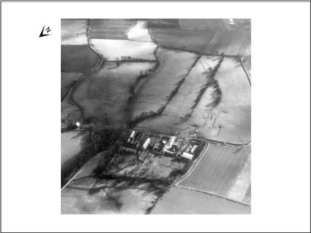
Mapping of archaeological features from aerial photographs records extensive areas of medieval ridge and furrow across the parish of Healaugh (NRHE: 1191998). Knitter Park and its garden features were laid out on top of medieval ridge and furrow ploughing and a headland (Figure 2). Enclosure of these open fields in the manor appears to be at a relatively early date as both the 1636 and 1718 map shows a pattern of irregular shaped fields and later maps show very few rectilinear enclosures. A number of curvilinear shaped enclosures are evident, which are characteristic of areas of woodland clearance or assarting.
Chronological history of the designed landscape
Despite the extensive archives of the Wharton family we have little documentary evidence to provide a detailed, dated chronology of the developments of the park and gardens surrounding the manor house. However, from what evidence we do have, we can identify three periods with very distinctive styles, reflecting different aspects of the designed landscape.
1217-1538
The medieval deer park, Healaugh Park, is an important component of the designed landscape. The date of its creation and licence to empark it is uncertain. The Domesday Book entry for Healaugh in 1086 does not record ‘parcus’ or ‘haia’, which might denote a deer park, but by 1217 when the Augustinian Priory was established the deer park existed. The full extent of the medieval deer park is uncertain. A moated enclosure containing a building may have been the site of a hunting lodge, dated by sixteenth century pottery and tile finds (Figure 3). There is evidence of deer being reared in 1512 and the park is recorded in 1538, and again in 1707. Although this might suggest continuity from the medieval period through to the post medieval period, the deer park seems to have evolved and the parkland redesigned and contracted in size after the dissolution of the monasteries.
The priory was given an area of land inside the deer park, which they enclosed within a ditch. The priory buildings were possibly enclosed within a stone precinct wall and the surrounding moat may have been constructed in this period. There is potential for evidence of associated medieval monastic gardens to survive.
1540 to 1568
Following Sir Thomas Wharton, First Baron’s purchase of Healaugh manor and the priory site, completed by 1540, he built an Elizabethan house, adapting and using parts of the quadrangular layout of the priory and using its building stone. We have some contemporary description of the house. Although the surrounding three-sided moat may have had earlier monastic origins, during this period it would have been an ornamental feature. Subsequent phases of rebuilding of the surrounding stone wall maybe contemporary with the house. An area named ‘the Garden’ lay adjacent to the house shown on a 1636 map. By 1718 the area is labelled Orchard and a small tree lined enclosure named ‘Cater Garth’, which lies to the east just outside the moat, may also have been an orchard or garden area (Figure 4a). This style of enclosed spaces with orchard and garden would fit well within the context of a sixteenth century garden associated with the Elizabethan house.
In the wider landscape, a deer park was undoubtedly a prestigious acquisition for the Wharton family. Saxton’s map of 1577 shows a curvilinear enclosure ‘Healygh’ south of Healaugh village, a depiction maintained on later maps in 1645 (Figure 5). The shape and extent of the deer park, named at this time ‘Helaugh Parke’, is more accurately shown on a 1636 map, enclosing an area of 240 hectares. Documentary and place name evidence suggests the medieval deer park was larger than the boundaries shown here, so this seems to represent a redesign of the parkland in the mid sixteenth century.
1673 to 1696
Thomas, Fifth Lord Wharton acquired the manor of Healaugh on his marriage in 1673 and in 1696, upon his fathers death he inherited properties in Buckinghamshire, which then became his main residence. In these intervening years between 1673 and 1696 is it likely that Thomas developed the gardens and designed the parkland surrounding the house at Healaugh Manor. An axial walk and tree avenue terminating in a semi-circular half-moon, lined with a double row of trees, adjoined the south frontage of the house and were probably laid out in the late seventeenth century. The broad walk extended into a small park, named ‘Knitter Parke’ (Figure 6). This style of garden design seen in the seventeenth century (Couch 1992, 174) would therefore fit within this period, before Thomas focused his attentions on his Buckinghamshire properties of Wichenden and Wooburn. The estate stayed in the Wharton family till Thomas’ death in 1715 and improvements were made, as the high quality brick wall surrounding the house and gardens had several phases of rebuilding.
Later History
By 1716, after the Brooksbank family had bought the estate, the manor house and its associated orchards, garden, parkland and woodland was let to a tenant John Milburne for £106. 10s. 0d. per annum (WYAS WYL68/2). Bowen’s 1750 map records the manor house as ‘Helagh mannor ruins’. Parts of the building and stone fabric were incorporated into later farm buildings that developed on the site (see 4.7). Stone from the house was also reused elsewhere. By 1843 the orchards had declined and the parkland and walk were divided and reverted back to an arable landscape (WYAS WYL68/14). The layout of the walk and half-moon is retained in field boundaries and they have recently been replanted with oak trees. In the wider landscape some elements of the deer park and its boundary became fossilised in the landscape, surviving along parts of the parish boundary, field boundaries and evidence retained in place names.
Location
The former site of Healaugh Manor and former priory, currently the site of several buildings, including East Manor Farm and West Manor Farm, is centred at SE 4857 4634, 2.9 kilometres to the north of Tadcaster and the River Wharfe (Figure 1). The garden features and small parkland associated with it lies to the south, centred at SE 486459. These were encompassed within a wider parkland and deer park, centred at SE 488466.
Area
The extent of the medieval deer park is unknown. The extent of the probable sixteenth century parkland as depicted in 1636 is 240 hectares. The area of the moated enclosure containing Healaugh Manor, its gardens, orchards and Knitter Park, as depicted in 1718 is 117 hectares (Figure 7).
Boundaries
The boundaries and full extent of the medieval deerpark is unknown.
The boundary and extent of the post medieval parkland ‘Helaugh Parke’ is depicted in 1636 (Figure 7). It ran from the western edge of Shire Oaks woodland north along the current parish boundary between Wighill and Healaugh civil parishes. It turned northeast towards Foss Bridge and east to Dews Wood (formerly Healaugh Spring), then south to meet The Foss. It followed this watercourse, then turned southwest to complete the circuit at Shire Oaks. Large parts of the parkland bank and ditch boundary have been levelled and only small lengths survive as earthworks.
The late-seventeenth century parkland is no longer extant. Its probable extent coincided in parts with the deer park boundary running along the west side of Knitter Park from Shire Oaks. Similarly on the eastern side The Foss formed the boundary of Mannor Plain and Lodge Plain. The southern boundary, formerly fringed by Horse Wood and Rath, has been removed and not visible above ground in the landscape today across arable fields. The northern boundary alignment is followed in parts by field boundaries (Figure 7).
Landform
The site of Healaugh Manor and the former priory is at 16 metres OD. The underlying geology is sandstone (Sherwood Sandstone Group) with overlying glacial till deposits of clay, sand and gravel (Vale of York Formation), creating gently undulating topography and hummocky terrain (British Geological Survey 2016). The loamy and clayey soils are seasonally wet, some with impeded drainage (Number 18 Soilscape: Cranfield University 2016). The Foss, Catterton Beck and numerous other watercourses and drains divide the landscape.
Setting
The immediate environs of the former manor house site is flat terrain with expansive views to the skyline across the former parkland. Occasional areas of woodland punctuate the skyline.
Current land use is farmland, enclosed by hedgerows, predominately arable with some pasture. Mature trees, such as oak, survive across the landscape along the hedgerow lines. There are small areas of mixed plantation and some ancient woodland. Shire Oaks (SE 482454) is identified as an important area for conservation in Selby District Local Plan (2005, 249), along with areas of marsh, Healaugh Priory Marsh (SE 487466), Healaugh Marsh (SE 492470) and a field north of Healaugh Manor Farm (SE 482468). The area falls within Selby District Local Landscape Character Area: The York Fringe, Type: Flat Wooded Farmland (Wollerton Dodworth Associates, 1999, fig. 2, p15).
Entrances and approaches
Before the parkland was laid out, the 1636 map (WYAS WYL68/62) shows a funnel entrance leading from ‘Shire Oakes Plaine’ approaching from the west to the south side of the house. There is no approach from the east depicted on the map, but probably existed as a road linking the former monastic site to Healaugh village, which lies to the northeast, is documented in 1223 (Purvis 1936, 7)
By 1718 (WYAS WYL68/63), when Knitter Park is established, a straight carriageway extended north- south, meeting a road from Tadcaster at its southern boundary. At its northern end the carriageway joined another track from the west, then continued northeast to pass on the south side of the house. A second approach from Healaugh village is also shown, extending across ‘Strait Piece’ and ‘Mannor Plain’, to reach the south front of the house. A building depicted along this route to the east of the house at SE 4874 4639 on the 1718 map (Figure 4a) may have served as stables, as it was adjacent to fields named ‘Stables Rash’ and ‘Stable Lawnes’ in the 1636. The building is now demolished.
Principal buildings
The buildings located at the site of the manor house and former priory are variously named and documented. Early accounts of 1635 refer to the building as a ‘capitall mesuage’ or ‘mannor house’ (WYAS WYL68/74/8). The 1636 map labels it ‘Helaugh house’. It is only in its later history, as the house converts to a farm, that in 1782 the buildings acquire the name ‘Healaugh Manor’ (WYAS WYL68/74/53b). Francis White’s 1785 map also confirms that name, but by 1790 it is recorded (WYAS WYL68/8) as ‘Old Manor Farm’. By 1888 the farm splits into ‘Healaugh Manor West’ and ‘Healaugh Manor East’ (WYAS WYL68/20). Some buildings within the complex, which have an earlier origin, are listed on the National Heritage List for England (NHLE) and have a photographic archive record held by Historic England Archive (Ref: BF095581).
The Elizabethan manor house incorporated remains of the medieval Augustinian priory and we have some hints as to its form and size as it is depicted on early maps. The 1636 (WYAS WYL68/62) map shows three sides of a building open on the south side. Attached on its northern side is a smaller range of buildings also arranged on three sides, thus forming an enclosed courtyard.
Judging by the hearth tax of 1672, which records 28 hearths for the ‘The Lord Wharton’, it was a house of considerable size. The 1718 map also shows three sides, open on the south side, as similarly depicted on Francis White’s 1785 map. Warburton’s 1720 map shows a front elevation with prominent east and west wings and a range between, but by this time is described as ‘Helah mannor ruins’.
An inventory of the house following the death of Sir Thomas, Lord Wharton, First Baron, in 1568, provides some hints of what the manor house was like, describing at least nineteen rooms and other out buildings. Evans (1945, 137) describes it thus:
It contained five living rooms, a hall, with a removable iron chimney flue for the fire; a dining chamber at the hall’s end, an outer great chamber and inner one; and the low parlour. For bedrooms there was my lord’s bedchamber, with dining room leading out of it, presumably an arrangement made in his invalid days; a great chamber, a third where my lord now lieth; my lady’s closet and various lesser rooms, a little one for an attendant by Lady Wharton’s room out of it, and the chamber at the stair-head a kitchen, brew house, back kitchen, store house and granaries.
The manor house was largely demolished and stone reused elsewhere, but parts survive incorporated within subsequent buildings of Healaugh Manor Farm complex. Three detached ranges retain architectural features dating from the late fourteenth century with alterations through to the twentieth century (NHRE: 54769, North Yorkshire Historic Environment Record (NYHER): SMR MNY30940). During his 1816 tour of Yorkshire W. M. J. Turner sketched the remains of the house named Healaugh Priory and the barn, showing architectural details and their setting within a group of mature trees (Hill 2008).
Some monitoring, test pits and geophysical survey undertaken during renovation of farm buildings within the moated enclosure, revealed evidence of earlier structures and building foundations of both brick and stone (Northern Archaeological Association 1997, 1998, 2008). Interpretation and discussion focused entirely on matching these to the possible plan of the former medieval priory buildings, but some may have also been part of the later manor house, which was not considered.
Healaugh Priory (NHLE: 1316677, Grade II*)
Healaugh Priory (formerly known as Manor Farm East) at SE 4857 4634, aligns north-south, is now a two-storey ashlar house. It incorporates a range of the priory circa 1150-1200, altered circa 1540 or later and appears to be the surviving east range of the sixteenth century Elizabethan manor. It has a battlemented parapet surviving on the west front.
Healaugh Manor West (NHLE: 1132458, Grade II)
Healaugh Manor West at SE 4851 4631, aligns east-west, is a brick built mid-nineteenth century house with twentieth century additions. It includes reused stonework from the priory buildings, runic fragments and medieval objects. Pevsner (1974, 258) describes fifteenth century or Tudor windows.
Barn to Healaugh Manor West (NHLE: 1316676, Grade II)
A stone and brick building at SE 4853 4632 used as a barn, nineteenth century, reusing earlier materials with an added twentieth century range.
Pigeoncote (NHLE: 1132459, Grade II)
Pigeoncote at SE 4859 4634 is eighteenth century with probable earlier origins, constructed of Magnesian Limestone and hand-made, narrow orange brick and pinkish-brown brick with pantile roof. Interior has brick nesting boxes.
Lodges
The 1718 map (WYAS WYL 68/63) shows three buildings within the parkland that are possibly parker’s or gamekeeper’s lodges rather than entrance lodges, as they lie southeast of the house and have no significant tracks linking them to the house. One building is within the centre of ‘Lodge Plaine’ and another two further north are depicted within woodland named ‘New Lodge Orchard’ (Figure 8a). ‘Lodge Plaine’ was formerly ‘Lodge Leyes’ on the 1636 map, suggesting a lodge existed there at this early date too. The central building is not depicted on subsequent maps, but Francis White’s 1785 map still shows those in the orchard labelled as lodge, but by 1790 (WYAS WYL68/66) the orchard is shown, but with no buildings within it.
A further building is significant as it may be a hunting lodge associated with the medieval deer park (NHRE: 54720). It lays 920 metres east of Healaugh Manor within a moated enclosure, which abuts the outside of the post medieval deer park boundary (Figure 7). The 1636 and 1718 maps name fields as ‘Old Lodge Lawne’ and ‘Old Lodge Garth’ respectively, flanking the deer park boundary. The 1849 Ordnance Survey map shows a small moated enclosure at SE 4947 4656 with two irregular shaped ponds surrounded by trees (Figure 7b), but by 1894 they become a single rectangular pond. Foundations of a rectangular building measuring 11 by 5.5 metres were recorded and sixteenth century pottery and tile fragments recovered. Tracks converge on the site, which remain footpaths today (Figure 3). The moat earthworks were visible on aerial photographs taken in 1963 and 1975 and by 1985 Field Investigators recorded it as levelled (NHRE: 54720). However, recent satellite images (Google Earth image accessed 18 July 2016) show evidence of wet ditches on two sides and a substantial internal bank surviving as earthworks.
Gardens
Moat
The site of Healaugh Manor lies within a moat, enclosing an area of approximately 2.5 hectares (6 acres) by a ditch on three sides, but open to the south where the road crosses in front of it (Figure 4). It is surveyed at 1:2500 and the moat ditch survives as an earthwork, recorded at depths of one metre in 1961 (NHRE: 54769, NYHER SMR: MNY17006). The western side has an entrance gap and the northern side has a second outer ditch along part of its length, enlarged in parts to form a fishpond. A moat of this neat rectilinear form would be ornamental, but the moat ditch would also provide a practical function, by aiding drainage of the heavy soils and creating a dryer raised platform for the buildings.
The date of the moat is uncertain. It may have been first constructed in the medieval period, enclosing the former Augustinian priory buildings. The occurrence of moats at Augustinian priories is found at other sites in England, but many similarly have post dissolution houses associated with them (E.g. Wymondley Priory, Hertfordshire, NRHE: 365124 and 365129.) The moat at Healaugh Priory is not mentioned in contemporary medieval documentary sources, therefore may be of post medieval construction, although remodelling an earlier moat as a later garden feature cannot be ruled out (Northern Archaeological Associates 2008, 3). The depiction on the 1636 map with a double line suggests it is in existence then. By 1718 the western side has developed an angled bend so perhaps remodelled and recut by this time (Figure 4a).
Gardens and Orchards
The earliest depiction on the 1636 map, labels ‘Healaugh house’ with ‘The Garden’ on its east side within a moated enclosure. By 1718 its depiction changes and a larger area north and east of the house is labelled ‘Orchard’. These are divided into two and the smaller one to the northwest is shaded green. This distinction may reflect that the two areas were planted and used in different ways, perhaps the eastern one being retained as a garden. Outside the moat, a further regular planting of trees depicted on its western side in 1718 may also be an orchard (Figure 4a). It becomes a larger area of woodland on Francis White’s 1785 map.
Following its conversion to a farm in 1790 the orchard inside the moat was described as ‘Old Manor Orchard’ measuring three acres (WYAS WYL 68/8) and by 1843 part was under grass (WYAS WYL68/14). The orchard within the moat continues to be depicted on subsequent editions of Ordnance Survey maps through to 1953 (Figure 9).
A brick perimeter garden wall surrounds the inside of the moated enclosure. An evaluation undertaken during renovations shows a number of phases and methods of construction and evidence of two different alignments. The wall is made of high quality brick and constructed using combinations of Herringbone Bond, English Bond and English Garden Bond, suggesting an eighteenth century date or earlier. However, the brick wall had limestone foundations beneath it. The quality of the dressed stone suggests these earlier phases may be contemporary with the medieval priory forming an enclosed precinct boundary wall (Northern Archaeological Associates 1998, 4; 2008, 12). Whether the stone wall was still extant, enclosing the post dissolution gardens is uncertain. Gun loops are incorporated into parts of the brick wall and may relate to an unrecorded use of the site during the English Civil War (ibid. 1998, 5, plate 9; 2008, 12).
Investigations within the former kitchen garden of the farm revealed earlier phases of building constructed of dressed Magnesian Limestone blocks. Along the current northern kitchen garden wall there were foundations of an earlier wall and a plinth for a gate pier (Northern Archaeological Associates 2008, 5). The potential for these to be part of the earlier manor house and associated garden features of the sixteenth or seventeenth centuries should not be overlooked.
Within the moated enclosure there were disturbed deposits up to 0.75 metres deep, with potential for preservation of archaeological deposits below that depth. It is therefore possible that features associated with the medieval monastic garden and later phases of post medieval garden may survive. No palaeoenvironmental samples were taken during the archaeological evaluations (Northern Archaeological Associates 1998, 4).
An enclosure abutting the east side of the moat is named ‘Carter Close’ in 1636. By 1718 it becomes a smaller (4 hectares or 1 acre) detached enclosure, ‘Cater Garth’ enclosed by trees and may have been an orchard or garden, providing a secluded and sheltered area. Its size increases by 1790 (WYAS WYL68/66) and the 1849 Ordnance Survey map depicts it as woodland named ‘Manor Wood’ (Figure 9). In 1843 (WYAS WYL68/43) a very small area (17 perches) of woodland is described as ‘Nursery adjoining Manor Wood’, supports the idea of this being a sheltered location used at that time for raising young trees.
Larger areas of orchard lie within the parkland with ‘New Lodge Orchard’ (1.1 hectares/ 2.7 acres) named on the 1718 map (see also 4.6). By 1787 (WYAS WYL68/7) the poor condition of the orchard is described as ‘fruit trees are few, old and of little profit’. ‘New Orchard’ (0.9 hectares/ 2.3 acres) appears on the 1790 map adjoining the western side of the tree avenue. Its decline is noted by 1843 (WYAS WYL68/14) when it is described as under ‘grafs’ (grass) and the 1849 Ordnance Survey map only depicts a few trees forming a small group in its southern part.
Walk
A tree lined walk depicted on the 1718 map extends from the south side of the house across the parkland, orientated SSE, although its axis is not exactly aligned with the quadrangular building layout. It is 70 metres wide and 660 metres long and depicted with a double row avenue of trees. Attached on it northern side is a semi-circular area named ‘Half Moon’, also planted with a double row of trees along its southern arc, with a gap to allow views from the house (Figure 6). Construction of these garden features probably dates between 1673 and 1696, created by Thomas Wharton, Fifth Lord Wharton (see 3.3). The 1636 map has no evidence of them and they were laid out on top of earthworks of former open fields of medieval ridge and furrow with substantial headland banks running obliquely across the avenue and walk (Figure 2). The first recorded depiction is on the 1718 map. By 1790 the avenue becomes divided into ‘Walk’ and ‘Little Walk’, the latter towards its southern end. By 1843 (WYAS WYL68/14) these former garden areas of ‘Half Moon’ and ‘The Walk’ are rented out and recorded as ‘grafs’ (grass). The 1849 Ordnance Survey map labels the entire avenue as ‘The Long Walk’. Recent aerial images (Google Earth, accessed 18 July 2016) show that the tree avenue and part of the arc of Half-Moon have been totally replanted with a double row of oak trees, which replaces the few older oak trees that remained, but are now removed.
The trees along the avenue and round the curve of the arc of Half-Moon were planted on top a banks, which were visible on aerial photographs taken in 1967 (NRHE: 1191646). Field Investigators observations, recorded in 1961 on an antiquity model diagram (NRHE: 54769), notes earthworks of a bank 3 metres wide and 0.4 metres high, with traces of a shallow external ditch 4 metres wide along the arc on the western side of Half-Moon. Although at that time these were interpreted as a possible continuation of the moat, it is more likely to be part of the construction for the semi-circular platform. By 1790 a small irregular shaped pond is shown in one corner, possibly designed to aid drainage of the moat.
The original design with trees planted on top of banks would have afforded a dry and shady walk. These garden features have parallels in other late seventeenth century gardens. A print circa 1700 by Knyff and Kip (1707) shows a similar wide walk at Londesborough Hall. It also has a semi-circular area in front of the house terrace, forming a grassy slope down to a tree avenue, flanked by single trees, extending for 700 metres southeast across the parkland. At Londesborough the single tree avenue develops into a more elaborate patte d’oie (radiating avenues in the shape of a goose foot), but there is no evidence of this pattern at Healaugh. Other contemporary examples at Hampton Court show the flat semi-circular area (310m x 190m) as an elaborate parterre with a fountain (Kynff and Kip 1707). The one at Healaugh is similarly flat, but much smaller (150m x 80m), and it is uncertain whether it was grass or a planted garden.
Park and plantations
Deer park
Just south of Healaugh Manor the 1849 Ordnance Survey map names Healaugh Park, recorded as a deer park (NHRE: 54802, NYHER SMR: MNY17020). From the evidence we have the deer park seems to have had at least two phases of development. There is substantial documentary evidence for ‘Helegh Park’ medieval deer park, but the date when it was first established is uncertain. In 1635 ‘Helaugh Parke’ is documented (WYAS WYL68/74/6A) and mapped in 1636 (WYAS WYL68/62), but this parkland appears to be smaller than the medieval deer park and was probably laid out post dissolution in the mid to late sixteenth century. There is evidence for this post medieval deer park continuing in use to 1707 and it was possibly maintained until 1711. Parts of its park pale boundary bank and ditch still survive as earthworks.
The Augustinian Priory of Healaugh Park was given land within the medieval deer park and in 1227 they were given ‘Protection by the King for the prior and canons of Helagh Park, their men and lands’ (CPR: Henry III, Vol. 2, 1225-1232, p173). Their land was contained within a ditched enclosure where they were given rights, but they also had restrictions outside in the wider deer park (Purvis 1936, 7 & 8). In 1311 there was a ‘grant by the King to the prior and convent of Helagh Park of free Warren in all their demesne lands of Helagh....’ (Purvis 1936, 118). This ‘free warren’ would allow them to hunt small game, or even roe deer (Mileson 1978, 4).
Outside the monastic land holdings the deer park continued to function and be used by lords of the manor. On 20 October 1298 William le Vavassour petitioned the king in respect of men who ‘broke his park and hunted therein and carried away deer.........The like to the same touching the persons who broke his park at Helewe, co. York.’ (CPR: Edward I, vol. III, 1292-1301 p383).
In 1351 there is a complaint by Alice, late wife of Stephen Waleys that ‘some evildoers broke her parks and entered her free chaces at Helagh and Cottyngley, co. York, hunted in these, and carried away deer from the parks, and hares, rabbits, pheasants and partridges’ (CPR: Edward III, vol. 9, 1350-1345, p78). It is interesting to note that areas of ‘free chases’ existed here, as these may have been outside the enclosed deer park boundaries, intermingled with settlement and farms (Jones 1993).
In 1405 Robert de Waterton requested grant for life ‘the offices of steward and master forester of the parks and forest of Spofforth and Healaugh with accustomed fees and wages’ (CPR: Henry IV, vol. III, 1405-1408 p73).
The Earl of Northumberland house book in 1512 records 319 red and fallow deer within the park (Shirley 1867, 218).
Leland’s observations circa 1538 describes the park:
From Helegh Priory, scant a mile to Helege village, there I saw great ruines of an auncient Manor Place of Stone that longgid with the fair Woddid Park therby to the Erle of Northumberland (Toulmin-Smith 1907, 44).
Saxton’s 1577 map provides evidence of the broad shape and location of the post medieval park. It depicts a curvilinear fenced enclosure named Healygh positioned to the south of Healigh (Healaugh) village. It is subsequently more clearly shown on maps by John Speed’s (1610) and Willem and Jan Bleau (1645) with a house symbol within the enclosure (Figure 5).
The memoranda on the margins of the 1636 map names ‘Helaugh Parke’ and ‘Catterton Parke’ and depicts them as two distinct areas on the map enclosed with a fenced symbol. It is debatable whether such a fenced symbol represents a deer park pale boundary, or just defining an area of parkland. In the context of Helaugh Parke it has been interpreted as the former, because of other supporting evidence, especially the extant remains of a park pale boundary bank and ditch, which encloses an area of 240 hectares (Figure 7).
In 1707 Lord Wharton’s Court Leet and Court Baron (WYAS WYL68/33) instructs the inhabitant of Healaugh and Catterton: ‘withes cut nor carry away any wood green or dry from my Lord’s Park.’ or they would incur a fine of 6s. This suggests the deer park was still in use at this time. But by 1720 Warburton’s map does not show any fenced enclosure. This demise of Helaugh Parke is illustrated on the 1718 and 1790 maps, which names an enclosure ‘Old Park’, previously in 1636 ‘Ralarke Nooke’.
There is further abundant place name evidence on the historic maps that includes ‘park’, which may indicate the extent of the medieval deer park. The 1636 map shows numerous enclosures outside the post medieval parkland boundary on its southeastern periphery named ‘Park Close’, which on later maps is divided into ‘Great Park Close’, ‘Near Park Close’ and ‘Far Park Close’. This suggests the medieval deer park was larger and had extended into these areas, or it simply signifies their close proximity to the parkland boundaries of both Helaugh Parke and Catterton Parke (Figure 7).
There are other place names outside the post medieval deer park boundary, which also seem to relate to deer park activities. The 1636 map has a curvilinear enclosure named ‘Old Lawnds at Parke Close’, which by 1718 (WYAS WYL68/3) is divided into ‘Far Lawne’ and ‘Lawns Pasture’. It possibly identifies the location of a ‘laund’ (grassy plain or pasture surrounded by trees) (Figure 7). A ditch and live thicket fence associated with this area is being maintained in 1707 (WYAS WYL68/33). The Court Leet and Court Baron of Thomas Wharton records that ‘A pain laid of the occupier of the Lawns shall ditch the ditch, and twist the trees sown for Philip Acomb....’(WYAS WYL68/33). The area abuts Catterton Beck and the boundary of Catterton Parke, as marked on the 1636 map.
Additional place name evidence of ‘Catterton Gap’, ‘Deer Ing Gate’ and ‘Dearing Gate’ recorded on maps and in ledgers (WYAS WYL68/7) and ‘Stubbing Gate’ on the 1849 Ordnance Survey map, possibly indicate the position of leaps in the park pale boundary, which were designed to let deer into the park, but restrict their egress (Cooper 2014, 12). Although, ‘gates’ and ‘gaps’ may also relate to activities of common grazing and controlling movement of livestock other than deer.
The enclosing park pale boundary bank and ditch and thicket fence would have been a prominent feature in the landscape. We have evidence for the western course of the boundary on later Ordnance Survey maps. ‘The Keepers Walk’, suggests a parker or gamekeeper’s role to deter poachers, and is labelled on the 1849 map coinciding with the parish boundary between Healaugh and Wighill (Figure 9). Edward Brooksbank (WYAS WYL68/44) describes this western course extending from almost Shire Oaks northwards to Nova Scotia Wood and notes it is ‘where we still claim the land on the far side of the fence as far as deer could jump, which is called a deer’s loup’.
Ordnance Survey Field Investigators evaluated the survival of earthworks of the deer park boundary circuit in 1963 (NRHE: 54802, source 4). They followed the route of the mapped 1636 boundary and record the internal ditch and external bank one metre high in places and note where the earthworks were denuded, or levelled and not visible. Some parts of the bank, aligned in places along field boundaries (E.g. at SE 4927 4643), were clearly visible as earthworks in 2005 (Google Earth image accessed 19 July 2016). The extent of the ditched enclosure boundary surrounding the lands given to Healaugh Priory is not known, and it is possible parts of it may have been incorporated into this post medieval parkland boundary.
An additional bank and ditch extends northwards from Foss Bridge to Nova Scotia Wood (SE 486473 to SE479489), beyond the post medieval parkland boundary. The Ordnance Survey Investigators interpret is this as part of the park pale of an attached deer park, ‘Wighill Park’ (NHRE: 54794) (Figure 7). Although, W & J Bleau’s map of 1645 shows this adjacent park as totally detached from Healaugh Park and named ‘Synnynthwate’ (Figure 5). This northern section of park pale from Foss Bridge to Nova Scotia Wood may possibly be the remains of the medieval boundary of Healaugh Park.
There is a paucity of paleobotanical evidence in the area to enable any reconstruction of the nature of the landscape within the former deer park, which is likely to have been a mixture of grassland and woodland. Enclosure names of ‘Cony Garth Flatt’ on the 1636 map are evidence of rabbit warrens in the parkland. Aerial photographs (Google Earth 31 Dec 2005, accessed 19 July 2016) show there are relict watercourses across the parkland (E.g. at SE 4899 4611), which have the potential to retain waterlogged deposits for recovering data on past vegetation history. The landscape is now devoid of much woodland, but there are some surviving areas of ancient woodland and documentary evidence from the eighteenth century to suggest the variety of species (see 4.9.2).
Parkland
Healaugh Park is the name of the wider medieval deer park, which is redesigned post dissolution to create a smaller deer park and parkland as discussed in 4.9.1. However, by 1718 a much smaller area of parkland surrounding Healaugh Manor developed associated with the designed landscape of a half-moon, walk and tree avenue. ‘Knitter Park’ lies to the west of the walk containing a long drive, with ‘Lodge Plain’ and ‘Mannor Plain’ to the east and areas northeast of the manor house are also probably parkland areas (Figures 6 & 7).
The seventeenth century parkland does not have any distinct perimeter, shelterbelt plantations enclosing and defining it on contemporary or later maps. But we do have evidence of woodland bordering the parkland areas in places. On the southern boundary are Shire Oaks, Rath and Horse Wood. Two areas northwest of the house, named ‘Near Nand Hagg’ and ‘Far CCland’, suggests former areas of copse, which fringed the parkland setting.
The 1636 map shows that the parkland area formally had smaller enclosed fields and trackways, and aerial photographs show some areas contained medieval ridge and furrow ploughing (NRHE: 1191998) (Figure 2). By 1716 (WYAS WYL68/2) the former parkland area had reverted back to its former state. A 1757 ledger (WYAS WYL68/4) records ‘Knitter Park’ and ‘Lodge Plain’ divided into smaller parts, under arable cultivation and ‘plowed’ (ploughed). The carriageway goes out of use and the sinuous trackway between the enclosures is reinstated by 1785, as shown on Francis White’s map and later maps. The 1849 Ordnance Survey maps do not stipple any areas, indicating it was not recognised as parkland then. Currently the former parkland areas are under arable cultivation.
Plantations and woodland
Today the heavy clayey and loamy soils do not support large areas of woodland, but there are a few small mixed woodland plantations. Some of the older boundaries retain mature trees, particularly oak and ash. There is evidence to suggest woodland was much more abundant in the medieval deer park. In 1201 Jordan de Sancta Maria and his wife Alice bought three hundred acres of woodland in ‘Helage Park’ (Speight 1902, 350-1). The most significant woodland is Shire Oaks (Shire Oakes in 1636) seen bordering the west of ‘Knitter Park’ on the 1718 map (Figure 6). The 1790 map shows it divided in two areas named ‘Shire Oaks’ and ‘Plain Part of Shire Oaks’ in the southern part. It is a prominent feature in the landscape, visible from the manor house site. The North Yorkshire County HLC (HNY5393) describes it as ancient semi-natural woodland, mainly dating before 1600, covering an area of 21.68 hectares/ 53.5 acres. Selby District Local Plan (2005, 249) lists the wood as important for nature conservation.
Place name evidence on the 1718 map, also suggests woodland was previously more abundant across the wider deer park. Field names include wood (E.g. ‘Horsewood Close’) and ‘hagg’ (E.g. Near Nand Hagg’). The latter are possibly former coppiced areas, which would have been an important part of the deer park landscape. ‘Stubbing’ names (E.g. Cork Stubbing) indicate cleared woodland with stumps remaining (Jones, 1993).
There are some hints as to the abundance, variety and decline of woodland in the wider manor of Healaugh and Catterton recorded in mid eighteenth century to early nineteenth century accounts, which overlaps with the areas of the deer park. An evaluation of timber in 1751 (WYAS WYL68/33) notes standing oak, ash and elm wood as 6042 trees, valued at £4671.18s.4d and divided into lots for sale. By 1782 (WYAS 68/78/53b) the number of oak, ash and elm trees was reduced to 3956. In 1843 (WYAS WYL68/14) only twelve areas of ‘woodlands in hand’ are named and cover 82 acres, 0 roods, 19 perches.
The variety of woodland resources is recorded in a letter of 1718 (WYAS WYL68/2) from Joseph Brooksbank’s agent, Joseph Dickinson. He notes there is ‘several spring woods 30 acres upwards, but the value of the wood is small’. We see evidence of this on the 1718 map, where several place names include ‘Spring’. This type of woodland probably represents former coppiced wood, which would have been an important element of the deer park landscape. There are also several enclosure names that include ‘Ellers’ (alder). Adjacent to Shire Oaks is another woodland named ‘Rath’, later named ‘Ellers’ then ‘Alders’, but it is no longer extant. Rath means ‘growing, blooming, or ripening early in the season’ and alder can be coppiced and it also makes excellent charcoal. Pasture wood recorded in 1782 (WYAS WYL68/74/53b) would also have been an important component of the former deer park (Jones 1993).
Books and articles
British Geological Survey 2016 Accessed 19.07.2016 at http://www.bgs.ac.uk/discoveringGeology/geologyOfBritain/viewer.html
Cooper, G. 2014. Salters (Deer-Leaps) in Historical Deer-Park Boundaries: A Case Study Using a 1608 Dispute Map of Leagram Park in Bowland.
Couch, S. 1992. ‘The practice of avenue planting in the seventeenth and eighteenth centuries’. Garden History Vol 20, No 2, Autumn, pp173-200.
Cranfield University 2016. The Soils Guide. Cranfield University, UK. Accessed 19.07.2016 at www.landis.org.uk
Dale, B. 1906. The Good Lord Wharton: His Family, Life, and Bible Charity. London.
Dale, B. 1909. Yorkshire Puritanism and Early Nonconformity: Illustrated by the Lives of Ejected Ministers 1660 and 1662. Bradford.
Evans, J. 1945, ‘An Inventory of Thomas Lord Wharton 1568’, The Archaeological Journal, 102, pp 134-150. London, Royal Archaeological Institute.
Gelling, M. 1984. Place-Names in the Landscape: The geographical roots of Britain’s place-names. London, J.M. Dent.
Hill, D. 2008. ‘Sketchbooks Used on Tour in Yorkshire 1816’, in David Blayney Brown (ed.), J.M.W. Turner: Sketchbooks, Drawings and Watercolours, Tate Research Publication, December 2013, https://www.tate.org.uk/art/research-publications/jmw-turner/sketchbooks-used-on-tour-in-yorkshire-r1144232 accessed 19 July 2016.
Jones, M. 1993. ‘South Yorkshire’s Ancient Woodland: The Historical Evidence’, in Ancient Woodlands - their Archaeology and Ecology: a coincidence of interest, in Landscape Archaeology and Ecology, Volume 1, edited by Pauline Beswick and Ian. D. Rotherham. Sheffield, Wildtrack Publishing
Knyff and Kip, 1707, Britannia Illustrata: Or Views of Several of the Queens Palaces, as Also of the Principal seats of the Nobility and Gentry of Great Britain. London (published in the winter of 1708 – 09). Engraving showing Londesborough from the west, around 1700. Plate 6, Hampton Court.
Mileson, S. A. 1978. Parks in Medieval England. Medieval History and Archaeology. Oxford, Oxford University Press 2009.
Northern Archaeological Associates, 1998. Healaugh Priory Tadcaster North Yorkshire: Archaeological Monitoring. Report NAA08/110.
Northern Archaeological Associates, 2008. Healaugh Manor East Farms, Tadcaster: An Archaeological Watching Brief for Healaugh Farms. Report NAA 98/34.
Northern Archaeological Associates, 1997. Geophysical Surveys at Healaugh Manor, Near Tadcaster, North Yorkshire. A programme of research carried out on behalf of Northern Archaeological Associates by Geoquest Associates.
Page, W. (Ed.) 1974. 'Houses of Austin canons: Priory of Healaugh Park', in A History of the County of York: Volume 3, pp. 216-219. London, Victoria County History
Pevsner, N. and Radcliffe, E. 1974. Yorkshire, The West Riding, The Buildings of England. Harmondsworth, Penguin.
Purvis, J.S. (Ed.) 1936. The Chartulary of the Augustinian Priory of St. John the Evangelist of the Park of Healaugh. The Yorkshire Archaeological Society, Record Series V. 92. Wakefield.
Seals, W. F. 1969. ‘The Brooksbank Family of Elland, Hackney and Healaugh’ privately published Accessed 19.07.2016 at http://paulfiddian.co.uk/documents/The%20Brooksbanks%20Family%20of%20Elland.htm
Selby District Local Plan (SDLP) 2005. Accessed 19.07.2016 at http://www.selby.gov.uk/sites-and-policies-local-plan-plan-selby
Shirley, E.P. 1867. Some Account of English Deerparks. London, John Murray.
Speight. H. 1902. Lower Wharfedale. Being a Complete Account of the History, Antiquities and Scenery of the Picturesque Valley of the Wharfe, from Cawood to Arthrington. London, Elliot Stock.
Trevelyan, W. C. 1832. ‘The Household Expenses, for one Year, of Philip, third Lord Wharton’, Archaeologia Aeliana, First Series, II, pp 224-242. Newcastle-upon-Tyne, Society of Antiquaries.
Toulmin-Smith, L. 1907. Leland’s Itinerary in England and Wales. London, George Bell and Sons.
White, G. 2005, The Nature and Purpose of the Original Furnishings and Decorations of Hardwick Hall, Derbyshire. Vol. 1. Thesis submitted to University of Warwick, Centre for the Study of the Renaissance.
Wollerton Dodworth Associates. 1999. Landscape Assessment of Selby District prepared for Selby District Council.
Primary sources
West Yorkshire Archive Service, Leeds (WYAS)
| WYL68/2 | A Particular Account of the severall Farmes in the Mannor of Healaugh taken only by inspection 1716 | 1716 |
| WYL68/3 | Survey Ledger for Joseph Brooksbank by Joseph Dickinson | 1718 |
| WYL68/4 | Survey ledger of Healaugh, Catterton and Tadcaster for Joseph Brooksbank | 1757 |
| WYL68/7 | Survey ledger of Healaugh and Catterton for Mrs Snell | 1788 |
| WYL68/8 | Survey ledger of lands belonging to Benjamin Brooksbank and Mrs Snell in Healaugh and Catterton by G. Lang | 1790 |
| WYL68/14 | Survey ledger of parish of Healaugh for Stamp Brooksbank | 1843 |
| WYL68/20 | Survey ledger Healaugh rents | 1888 |
| WYL68/33 | Bundle misc. C18 papers: Court Leet and Court Baron for Thomas Earl of Wharton for Manor of Healaugh and Catterton A valuation of Oak, Ash and Elm wood standing in Manor of Healaugh and Catterton |
1707
1751 |
| WYL68/44 | Notes on the history of Healaugh by Sir Edward Brooksbank | late C19 - early C20 |
| WYL68/62 | Map of Helaugh, Catterton and Synnithwaite by W.F Rapire | 1636 |
| WYL68/63 | Map Manor of Healaugh and Catterton by Joseph Dickinson | 1718 |
| WYL68/66 | Reduced map Manor Healaugh and Catterton | 1790 |
| WYL68/67 | Map of the manor of Healaugh according to settlement of 1782 | 1815 |
| WYL68/74/6A | Indenture: Philip Lord Wharton | 1634 |
| WYL/68/74/8 | Indenture: Philip Lord Wharton | 1635 |
| WYL68/74/29 | Indenture: Thomas Wharton, Joseph Brooksbank and William Waller. | 1714 |
| WYL68/74/53b | Marriage settlement for Stamp Brooksbank [lists timber] | 1782 |
Maps
Christopher Saxton (Eboracensis Comitatus f.61) 1577
John Speed, West Riding of Yorkshire 1610
Willem and Jan Bleau, West Riding of Yorkshire 1645
John Warburton, map of Yorkshire 1720
Francis White, York and Ainsty map, 1785
Ordnance Survey 1st edition, 6”, Surveyed 1846 to 1847, Published 1849
Ordnance Survey 2nd edition, 6”, Surveyed 1891, Published 1894
Ordnance Survey one inch, Revised 1896, Published 1898, Sheet 70 (Hills)
Figure 1 - Location of Healaugh Manor (former site of Healaugh Park Priory) and Hall Garth (former manor site), Map base contains OS data © Crown copyright and database right 2016
Figure 2 - Aerial photograph looking across Healaugh Manor to former garden and parkland features overlying medieval ridge and furrow ploughing, AQS90 04-FEB-1967 Cambridge University Collection of Aerial Photography © copyright reserved
Figure 3 - Moat east of Healaugh Manor contains possible hunting lodge adjacent to converging tracks, Ordnance Survey one inch, Revised 1896, Published 1898, Sheet 70 (Hills), Reproduced by permission of the National Library of Scotland
Figure 4a - Healaugh Manor moat containing orchards with ‘Cater Garth’ and possible stables to the east, 1718 map by Joseph Dickinson, West Yorkshire Archive Service WYL68/63
Figure 4b - Moat water filled ditches on three sides with fishpond on northern side, Map base contains OS data © Crown copyright and database right 2016
Figure 5 - ‘Healygh’ deer park south of ‘Healigh’ settlement, 1645 West Riding of Yorkshire map by W & J Blaeu, Reproduced by permission of Sheffield Local Studies Library: Picture Sheffield www.picturesheffield.com
Figure 6 - ‘Walk’ and ‘Half Moon’ garden features within ‘Knitter Park’, 1718 map by Joseph Dickinson West Yorkshire Archive Service WYL68/63
Figure 7 - Healaugh Park phases of development and its wider landscape context, Google Earth image © 2016 Infoterra Ltd & Bluesky
Figure 8a - Lodge in New Lodge Orchard, 1718 map by Joseph Dickinson, West Yorkshire Archive Service WYL68/63
Figure 8b - Lodge in moated enclosure is possible hunting lodge, Ordnance Survey 1st edition, 6”, Surveyed 1846 to 1847, Published 1849, Reproduced by permission of the National Library of Scotland
Figure 9 - Healaugh Manor Wood with orchards and ‘The Keepers Walk’ deer park boundary, Ordnance Survey 1st edition, 6”, Surveyed 1846 to 1847, Published 1849, Reproduced by permission of the National Library of Scotland
 and Hall Garth (former manor site).")


 Healaugh Manor moat containing orchards with ‘Cater Garth’ and possible stables to the east; b) Moat water filled ditches on three sides with fishpond on northern side.")


 Lodge in New Lodge Orchard; b) Lodge in moated enclosure is possible hunting lodge.")
