Although Kiplin Hall dates back to the early 17th century, it was Christopher Crowe who first started shaping the designed landscape we see today from 1722. Apart from some small garden areas next to the hall, the rest of the estate was enclosed fields at this point. The main public road ran next to the hall and Crowe had this moved further east to allow him to start expanding his gardens, including the extant walled kitchen garden. His son, also Christopher, continued his father’s work from 1749 but it was his nephew, Robert, who enabled the expansion of the grounds eastwards with the move of the public road again in 1792. He may have put in the lake and created the northern carriageway around this time.
Robert’s daughter, Sarah, and her husband, John, Earl of Tyrconnel, had grander ambitions on inheriting in 1818 that included expanding the parkland to its present extent and developing the kitchen garden and the pleasure grounds. The final improvements came with the ownership of Walter Carpenter who employed William Eden Nesfield, the architect and landscape designer, between 1874 and 1880. This included the formal gardens around the hall, new shrubberies and changes to the new carriageway from the east lodge, where later a lime avenue was planted in 1891.
This proved to be the zenith of the estate and during the first part of the 20th century it slowly declined under the ownership of Carpenter’s daughter, Sarah. Her cousin, Bridget Talbot, took it over in 1937 and in 1968, set up the Kiplin Hall Trust to try and preserve it. The Trust still owns the hall and immediate grounds. Although the western parkland was largely lost due to quarrying, much of the historic park and garden to the east and south of the hall remains.
Estate owners
Kiplin was granted to Easby Abbey in the 13th century, who held it as a grange until it passed to John, 8th Lord Scrope of Bolton, at the Dissolution in 1537. In 1559, the estate was purchased by Thomas, 1st Lord Wharton (NYCRO ZBL I 1/1/2). The Wharton family sold it in 1619/20 to George Calvert, 1st Baron Baltimore (NYCRO ZBL I 1/1/3-4). It remained with the Calvert family until Charles, 5th Baron Baltimore sold the manor of Kiplin in 1722 to his stepfather, Christopher Crowe (the Elder) (Page 1914, 307).
On Crowe’s death in 1749, his son, Christopher, inherited. On the latter’s death in 1776, the estate passed to his younger brother, George and then to George’s eldest son, Robert, in 1782. Robert’s daughter, Sarah, and her husband, the 4th Earl of Tyrconnel, inherited from her father in 1818. After Sarah’s death in 1868, the estate went to the Earl’s cousin, Captain Walter Cecil Talbot, who changed his name to Carpenter as a condition of his inheritance. Admiral Carpenter left Kiplin to his daughter Sarah (later Turnor) in 1904. Sarah’s cousin, Bridget Talbot, bought the Hall in 1937 and after Sarah’s death in 1957, she inherited the rest of the estate. Bridget set up the Kiplin Hall Trust in 1968, which took over the Hall and estate upon her death in 1971.
Key owners responsible for major developments of the designed landscape and dates of their involvement:
George Calvert, 1st Baron Baltimore (1620-32)
Christopher Crowe the Elder (1722-49)
Christopher Crowe the Younger (1749-76)
Robert Crowe (1782-1818)
John, 4th Earl of Tyrconnel (1818-53)
Sarah, Countess of Tyrconnel (1818-68)
Walter Cecil Talbot Carpenter (1868-1904)
Bridget Talbot (1937-71)
Kiplin Hall Trust (1971-)
Early history of the site
The location of the medieval grange at Kiplin that belonged to Easby Abbey is not known, but was most likely in the area of the modern hamlet of Kiplin to the south of the hall. On 16 December 1557, Henry, 9th Lord Scrope, was granted the grange and its lands in Kiplin by Queen Mary and then sold it on to Edward Kirtling and Richard Allyngton the following year (NYCRO ZBL I 1/1/1). In January 1620/1, the 800-acre Kiplin estate was purchased from the Wharton family for £2,500 by George Calvert. It comprised of ‘the Mansion and manor house, capital messuage, hamlet, town and grange of Kiplin, demesne etc. and water corn mill’ (NYCRO ZBL I 1/1/4). This, together with recent archaeological evidence (Brightman et al 2017, 115), suggests there may have been a building on the site of the present hall in the 16th century. Calvert had been born at Kiplin, as his father had been a tenant of the Whartons.
The present Kiplin Hall was built c. 1622-1625 by George Calvert, but with interests in London, Ireland and America, he spent considerable time away from Kiplin. Later generations of the immediate Calvert family lived in the south of England or Maryland, so the Hall was not their principal residence. Instead it was occupied by their relatives from the Smithson family, as George’s sister, Dorothy, had married Christopher Smithson. In the 1673 Hearth Tax return for Kiplin, Mr Calvert Smithson is recorded for the hall, a building of twelve hearths (Ripon Historical Society 1991, 20). The 17th century hall’s grounds are probably those shown on a map prepared for Christopher Crowe in 1723 of his newly-acquired estate (NYCRO ZBL M1, Figure 1). Apart from two enclosed gardens to the south, the rest is largely fields with an area of woodland to the south.
Chronological history of the designed landscape
1722 – 1818
Following his acquisition of Kiplin in 1722, Christopher Crowe and his son, Christopher, purchased property and large areas of farmland, increasing the estate’s holding to about 4,500 acres. They embarked upon a programme of improvements to the house and grounds including repairs to the hall in the 1720s and 1730s (NYCRO ZBL IV 3/1). It was possibly at this time that the public road that ran immediately east of the hall was moved further east (Brightman 2017, 116-7) as shown on the later diversion map (NYCRO QSB/1793 Q2/13). In 1741/2, there are references to works on a garden house, which may have been a greenhouse. Its location is unknown but may have been part of the development of the grounds to the north of the hall, including the walled kitchen garden, which had been made possible by the move of the public road. By 1780, a painting by Cuit showed that the walled garden areas to the south had been removed and pleasure grounds had been added by 1782, as John Carter ‘formerly George Crowe’s menial servant who now works in his garden and pleasure ground’ was left money in Crowe’s will (NYCRO ZBL II 63).
From 1741 to 1746, the Fishers supplied trees each year, including 200 elms for £8 in 1744 and on 4 Jan 1745, 160 elms (NYCRO ZBL IV 3/1/21-26). Jeffrey’s map of c. 1771 showed trees to the (north)west of the hall, possibly to screen the hall from the public road and to the east that would later be part of the pleasure grounds and park. When Arthur Young visited Kiplin in 1768, he observed that Christopher Crowe
‘totally disapproves of setting trees in hedges...But the method used by this gentleman is to plant screens in such situations about his estate, as best defend it from the injury of winds…By means likewise of appropriating slips of land to this purpose, the trees are planted at any age, and as they are well fenced in, are secured from all injuries.’ (Young 1771, 228-30).
Young also stated Crowe had repaired or rebuilt many of the farm buildings after inheriting in 1749. He also mentioned that the farm where his bailiff resided, there was a ‘neat room for drinking tea in, (as it is at a proper distance from the house). This building is no flight ornament to his grounds; it is elegant as well as useful’ (ibid, 228-9). The location of this building is not known.
Robert Crowe, Christopher’s nephew, had inherited in 1782 and he made significant changes to the landscape following the move of the public road again further east away from the hall in 1793 (NYCRO QSB/1793 Q2/13). This allowed for the development of the eastern pleasure grounds and parkland from what had previously been fields. It was also probably at this stage that Kiplin Beck was dammed to create a serpentine lake to the west. An undated, field book (c. 1818) listed the areas attached to the Hall, totalling just under 61 acres (NYCRO ZBL IV 5/13). These included:
Kiplin Hall and Offices, Yards, Bowling Green & half of the beck – 2a 3 14p
Walled kitchen garden comprising of Inner Garden (3r 32p), Flower Garden (11p) and Out Garden (1r 9p) – 1a 1r 12p
Pleasure Ground with Long Garden – 3a 27p
Near Paddock – 2a 2r 20p
Far Paddock – 1a 2r 27p
Levels – 9a 1 38p
High Walk, James Walk and Walk north of Hugh Close – 4a 3r 3p
Harber Hill – 11a 1r 34p
1818-1868
When Robert Crowe died in 1818, the estate passed to his daughter and her husband, the Earl and Countess of Tyrconnel. Almost immediately, they had plans drawn up by the architect P.F. Robinson for alterations to the Hall on the south side (NYCRO ZBL M17-19). From the second survey (undated but c. 1840, NYCRO PR/BOL 4/2) and the tithe map (1839, Figure 2), an area of parkland (the ‘Levellings to Gravel Walk’, no. 48) had been laid out covering just over 48 acres. There was no reference to the bowling green previously next to the Hall possibly on the western side, so this must have been removed and the shrubbery (no 4), pleasure grounds (no 6) and plantation (no 46) now covered just under 8 acres. On the 29 June 1832, Lord Tycronnel noted in his diary that ‘the laurels which I planted dying’ (Kiplin Hall Trust) and on the following day ‘hollies and laurels look ill and most dead’ (ibid). These were for the shrubbery south and east of the kitchen garden.
The tree-lined drive to the Hall along the east side of the serpentine lake via a lodge to the northwest was created sometime between the late 18th century and 1839, as was another carriageway from the southeast through the parkland. The two areas to the north of the walled kitchen garden were still described as paddocks but were slightly smaller than the previous survey due to the buildings adjacent to the kitchen garden including a new vinery. On 30 June 1832, Lord Tyrconnel described the failure of the crop of grapes in the ‘new house’ (Kiplin Hall Trust), suggesting that others were grown elsewhere, possibly in the 18th century ‘garden house’. There was also a building shown on the outside of the southern wall near or on the site of the later conservatory that may be the location of the other possible greenhouse/vinery.
By 1854, there was a pair of lodges flanking the entrance to the south east of the parkland (1st edition 6” OS map, Figure 3) and the shelterbelt had been extended north to completely screen the hall from the public road. The former ‘Near Paddock’ was now an orchard with additional glasshouses shown to the north along the wall next to the south side of the main road. Similarly the former ‘Far Paddock’ was now a garden area (‘Lady Tyrconnel’s). Following Lady Tyrconnel’s death in January 1868, a sale of bedding plants from the Hall included 39 varieties of geraniums, a collection of fuchsias and many other annuals. In September, the executors of Lady Tyrconnel’s estate sold … a Choice Collection of Stove and Greenhouse Plants, Orchids etc, including Acacia, Mimosa and Hibiscus (NYCRO ZBL IV 6). A summer house had been added at the northern end of Peninsula Wood and although an exact date of construction is not known, the presence of post 1784 type bricks in the excavation and other evidence suggests a date between 1820 and 1840 (Brightman 2017, 118-9).
1868-1904
Following Lady Tycronnel’s death, the hall and estate were offered for rent for 3 years:
Furnished Mansion House, Park Shooting & Fishing To Be Let & entered upon this Spring. Description included ‘shooting over 3000-4000 acres & fishing on 1 side of River Swale for c.3 miles...coach houses, stables & out-offices; Flower and Kitchen Gardens are attached with a large Conservatory, Vineries, Peach Houses, 7 Forcing Houses. The mansion is situated in a Park with a large ornamental piece of water in front. (7 March 1868, NYCRO ZBL IV 6)
In 1869, Charles Stead and George Hodgson, took a lease on the property. Their contract included the maintenance of the gardens:
‘The tenants to maintain and keep up the gardens and garden walks and keep up the Vineries Forcing Houses and other Garden Structures in the same state of repair and condition as at present. The Tenants to purchase from the proprietor all the camellias and azaleas on a valuation in the usual way…The Tenants to retain and keep well cultivated and grown all vines and fruit trees in the vineries and gardens and prune and dress them as well as the rose trees and other flowering shrubs…And the Vegetable garden cultivated with full crops of a similar kind and to the like extent as at present’ (NYCRO ZBL IV 2/1/104).
The new owner, Walter Carpenter, took up residence and engaged the architect and landscape designer, William Eden Nesfield, to remodel the interior of the hall and to add a new stable wing. He also created the formal gardens to the east and sunken garden to the south, working with the landscape contractor, Joseph Meston, and nurseryman, William Dimes. After the works on the main buildings were completed by 1877, the focus turned to the grounds. By early 1878, Meston had laid out a new drive from the front of the Hall through the parkland to the east, costing £630 (NYCRO ZBL IV 3/16).
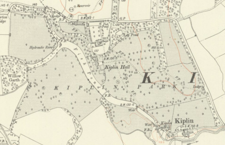
On 23 May 1879, Nesfield submitted a tender for ‘laying out Garden, Shrubberies etc. in connection with Mansion’ at a cost of £423 (NYCRO ZBL IV 6/6). This involved enclosing an area around the hall from the road to the stables in the east to the lake on the west with an iron fence and hollies. Within the area would be the forecourt, a sunken croquet lawn, a rosary of mixed standard, half-standard and dwarf varieties and shrubs on the western side towards the lake (Figure 4). The paths were to be lined with yew hedging. These works were completed by the end of 1880. On 8 August 1879, Meston also quoted for ‘Mudding Out Lake. Area from footbridge to upper end including Ellerton branch…Area c.7.75 acres…cost £950. Take about 12 weeks. All mud put on one side of lake away from pleasure grounds and left to dry before being removed’ (ZBL IV 1/1130).
Walter’s diary for 1891 mentioned the planting of the first tree in the Avenue of Limes on 2 February. He also confirmed the work carried out at Kiplin by Nesfield:
‘A new approach from Northallerton Lodge was planned by William Eden Nesfield as well as courtyard front gates, yew hedges and a rose garden and terrace around the house…Yew hedges to the east of the house and all the planting of clumps of specimen trees etc and laying out of the ground must have been done between 1874 and 1878’ (Kiplin Hall Trust).
Later history
After Sarah Carpenter inherited, she progressively sold off land, farms and cottages, reducing the estate of over 5,000 acres to 120 acres of gardens, parkland and woodland. The hall was occupied by tenants until Bridget Talbot bought it in 1937. During WW2, when it was occupied by troops, the gardens were neglected and the lake was drained. When the Trust took over the management of the Hall and estate in 1971, the property was in poor condition.
To raise funds in the early 1990s, the west parkland was given over to gravel quarrying, thus creating a large lake to the west of Kiplin Beck, removing the serpentine pond. Between 1998 and 2000, the Trustees undertook major restoration work on the Hall and further work to restore the gardens and grounds began in 2009, with the appointment of a head gardener. New garden areas have now replaced some of the historic areas.
Location
Kiplin Hall is 8 miles equidistant from Northallerton and Richmond and 2 miles from Catterick to the west.
Area
The historic designed landscape covered 55 hectares (136 acres) at its greatest extent.
Boundaries
It is bounded to the north and east by the B6271 Northallerton to Richmond road. To the south, its boundary is formed by Kiplin Beck from the public road to Kiplin mill and then to SE 269 972. To the west, the boundaries follow the western edge of the former parkland and Willow Garth until it meets the public road next to Ellerton Bridge.
Landform
Kiplin’s underlying bedrock geology is glacial till (Boulder Clay), with undifferentiated alluvium and river terrace deposits. The soils are Dunkeswick (711p), loamey over clayey soils, and Alun (561c), river alluvium, which are deep, stoneless, permeable silty soils, with gravelly subsoil in places; flat land with a risk of flooding (Soil Survey of England and Wales 1983).
Setting
Kiplin is situated within the Vale of Mowbray National Character Area, within the lowland flood plain of the River Swale, between the uplands of the Pennines to the west and north York Moors to the east. The Hall, immediate gardens and parkland lie on a relatively level alluvial terrace of the River Swale, between 39 and 41m OD, with the land to the north rising to 43m AOD.
Entrances and approaches
North West Gateway and Lodge [Grade II, NHLE 1150208]
Gate piers, wrought-iron gates and lodge described in listing as late 18th century at the approach to the Hall from the north off the B6271 at SE 271 977.
East Gateway and Lodge [Grade II, NHLE 1150207]
Gate piers and wrought-iron gates described in listing as late 18th century at the approach to the Hall from the southeast, off the B6271 at SE 280 973. Lodge c.1870 by Nesfield replacing previous one.
Northern entrance from B6271 at Gardener’s Cottage
This is currently the main vehicular access to the Hall. This is a modern entrance but may lie on the public road that was moved in the first half of the 18th century.
Gatepiers, gates and railings [Grade II, NHLE 1294767]
Gatepiers, wrought-iron gates and railings to the immediate east of Kiplin Hall at SE 274 974, leading into the eastern parkland, 1879 by Nesfield.
Principal buildings
Kiplin Hall [Grade I, NHLE 1315476]
Built c. 1622-1625 with alterations in early 18th century, 1818/9 and 1870s.
Fruit Store and Coach House [Grade II, NHLE 1188393]
Located c.100m north of Kiplin Hall at SE 274 976, c.1870 by Nesfield.
Former Servants’ wing [Grade II, NHLE 1188445]
North of the main building of Kiplin Hall at SE 274 975, 18th century, with later alterations of the 19th century and 1980.
Stables
Located immediately to the north of Kiplin Hall at SE 274 975. Now demolished.
Icehouse
Located at SE 273 978, probably built between 1818 and 1839 as no reference before tithe map.
Gardens and pleasure grounds
There is no documentary evidence as to the gardens that may have been laid out when the present Kiplin Hall was built in the early 17th century. The first map of 1722 (Figure 5) shows two walled enclosures to the south of the hall that were probably garden areas as trees are marked there. Due east of the hall was a forecourt and a bowling green (to the west?) was mentioned in later documents, a feature that was popular in the second half of the 17th century. The area immediately north of the hall next to the road and to the northwest may well have been developed from the 1740s onwards, as by the 1780s some limited pleasure grounds were in place. However it was not until the road was moved in 1793 that there was the space to develop the grounds further east.
By c. 1818, the pleasure grounds covered just over 3 acres with 2 further areas, Levels (c. 9½ a) and High Walk, James Walk and Walk north of Hugh Close (c. 4¾ a) possible landscaped areas. In the 1830s, the pleasure grounds included a small shrubbery next to the kitchen garden and a plantation of nearly 5 acres (Figure 2). Two further garden areas were developed in the former paddocks north of the kitchen garden, with the western section becoming an orchard and the eastern, ‘Lady Tycronnel’s garden’ with the latter having shrubs, flower borders and a pond.
Between 1879 and 1880, new gardens were laid out to the south of the hall by Nesfield. These included a rose garden, croquet lawn and further areas of shrubbery to the southwest (Figure 4). These areas remained in-situ until the 1940s when they were removed. They were replaced by new designs and planting in the last 10 years.
Kitchen garden
The present walled kitchen garden was laid out probably in the mid-18th century when the public road was moved slightly further east away from the hall. By c. 1818, it covered 1¼ acres and comprised of a main ‘Inner Garden’ (3r 32p), a ‘Flower Garden’ (11p) and an ‘Out Garden’ (1r 9p). It was expanded slightly in the 1830s to just over 1½ acres with a new vinery added in c. 1832. The tithe map of 1839 (Figure 2) shows the garden (No 5) together with buildings at the northern edge and one attached to the southern wall. The former are probably the new glasshouses with adjoining boiler rooms and bothies. The latter may be the ‘garden house’ referred to documents from the 1740s. Between 1839 and 1854, the northern range had been expanded and with the conversion of the Near Paddock to an orchard, another glasshouse was added next to the road. By 1868, there were vineries, peach houses and 7 forcing houses. It would appear that the southern greenhouse had been replaced by a conservatory just east of it before 1853 (Figure 6).
With the remodelling of the grounds in the late 1870s, there were further changes mainly to the buildings inside and next to the walled garden. Richardsons of Darlington supplied garden frames and a greenhouse in 1882 for £160, heating apparatus for the ‘Long Vinery’ costing £108 in 1883 and a new boiler for the Long Vinery in 1892 (NYCRO ZBL IV 3/16).
Park and plantations
Eastern Parkland
Created from 1793 and expanded to current extent of c. 53 acres by 1854.
Western Parkland
Laid out between 1839 and 1853 and covered c. 47 acres. Largely quarried for mineral extraction in the 1990s and restored as a lake with central island.
Lime Avenue
In eastern parkland, planted in 1891.
Peninsula Wood
In eastern parkland, c. 8 acres and possibly planted between 1818 and 1839, although eastern section may be earlier.
Water
Lake/Fish Pond
West of house from damming of Kiplin Beck, created before 1839 but had been drained by mid 20th century.
Pond
Together with dipping platform in northern section of Peninsula Wood adjacent to Shrubbery, it had been created by 1839.
Tufa pond
In Lady Tycronnel’s garden, created between 1839 and 1854
Books and articles
Brightman, J. et al. 2017. Charting Chipeling: The Archaeology of the Kiplin Estate. Northallerton: Solstice Heritage.
Page, W. (ed.) 1914. A History of the County of York, North Riding. Volume 1. The Victoria History of the Counties of England. London: Victoria County History.
Ripon Historical Society & Ripon, Harrogate & District Family History Group. 1991. The Hearth Tax List for the North Riding of Yorkshire. Michaelmas 1673. Part Two. Allerton, Gilling East, Hallikeld & Hang East Wapentakes (NYCRO CRONT 1453).
Young, A. 1771. A Six Months’ Tour through the North of England, Volume 2. London: printed for W. Strahan & W Nicholl.
Primary sources
Kiplin Hall Trust (KHT)
Painting of Kiplin Hall by George Cuit the Elder, 1780
Transcripts of the journals of John Delaval Carpenter, 4th Earl of Tyrconnel, 1832-1833 & 1843-1853
North Yorkshire County Record Office (NYCRO)
PR/BOL 4/2 Survey book, containing schedules and neat sketch plans for High Kiplin, Kiplin Home Farm, Kiplin, Ellerton, Bolton, Scorton and Catterick farms, nd [c.1840]
QSB/1793 Q2/13 A Plan of proposed alterations of roads in the Township of Kiplin 1793
ZBL IV 1 Kiplin Hall correspondence 1732-1931
ZBL IV 3 Kiplin Hall accounts 1737-1935
ZBL IV 5/13 Field book of the Kiplin Estate nd [c.1818]
ZBL IV 6 Kiplin Hall agents notes and papers 1740-1936
ZBL M1 A map of the Estate of Christopher Crow esq. Lying at High Kiplin and Low Kiplin in the parish of Bolton and in the County of York surveyed June the fifth 1723
ZBL M17-19 Three plans for the proposed alterations to Kiplin Hall by P.F. Robinson, architect, acting for the Earl of Tyrconnel, 1818
The National Archives (TNA)
IR 29/42/203 Tithe apportionment for Kiplin, 19 November 1839
IR 30/42/203 Tithe map for Kiplin, 1839
Maps
Ordnance Survey 6” 1st edition, surveyed 1854, published 1857
Ordnance Survey 25” 1st edition, surveyed 1891, published 1893
Ordnance Survey 25” revised edition, revised 1912, published 1913
Ordnance Survey 25” revised edition, revised 1927, published 1928
Figure 1 – Map of the estate of Christopher Crow esq. 1723. Reproduced by permission of the North Yorkshire County Record Office (ZBL M 1).
Figure 2 – Tithe map of the township of Kiplin, 1839, showing lake, parkland, Peninsula Wood, ponds and walled kitchen garden. © The National Archives.
Figure 3 – Parkland to the east and west of the Hall, pleasure gardens, orchard, walled kitchen garden, fish ponds and summer house. 1st edition 6” OS map, surveyed 1854, published 1857. National Library of Scotland CC-BY.
Figure 4 – Changes by William Eden Nesfield, including new gardens around the house. 1st edition 25” OS map, surveyed 1891, published 1893. National Library of Scotland CC-BY.
Figure 5 – Detail of map of the estate of Christopher Crow esq. 1723, showing hall and gardens. Reproduced by permission of the North Yorkshire County Record Office (ZBL M 1).
Figure 6 – Walled kitchen garden and orchard. 1st edition 6” OS map, surveyed 1854, published 1857. National Library of Scotland CC-BY.
.")


.")
