The Kirkby Hall estate lies on a large, open plateau overlooking the River Swale to the east. It comprised an 18th-century designed landscape with a long, narrow woodland terrace and garden buildings, landscape park, lake, stream and pleasure grounds.
The present house is a mid- to late- 18th-century Georgian mansion, lying adjacent to St Mary’s Church. Purchased in 1724 by William Aislabie, who also developed the landscapes at Studley Royal, Hackfall (both Grade I on the Historic England Register of Parks and Gardens of Special Interest), and Laver Banks, Kirkby Hall is one of the earliest examples of his work. Much of the related archive material no longer survives. However, from accounts and letters in the Vyner Papers held by the West Yorkshire Archive Service dating between 1742 and 1760, it is possible to gain some idea of the nature and date of the works that were undertaken.
The garden buildings no longer survive, there has been additional tree planting and areas of the former park are now under arable cultivation. Nonetheless, a large part of the designed landscape remains intact today, albeit in multiple ownership.
Estate owners
Kirkby Fleetham was once two distinct places with separate manors, Kirkby and Fleetham, which followed differing lines of descent. The location of the present village to the south is believed to be that of the manor of Fleetham; of the manor of Kirkby, situated to the north, only the church and Kirkby Hall remain. The two were united in 1670, when both manors were held by the Smelt family and known jointly as the manor of Kirkby Fleetham.
Kirkby
In the Domesday Survey of 1086, Aldred held the manor. The demesne titles were taken by the Stapleton family until 1514, when Sir Thomas Metham let the lands to William and Elizabeth Conyers, and shortly afterwards to William Belforth. The Metham family heirs sold the manor in 1600 to Leonard Smelt, who died c.1627. He was succeeded by his son Matthew (d.1653, TNA PROB 11/226/631), who passed the manor to his son Leonard (d.1690), who himself had a son named Leonard (c.1683-1740) (Page ed. 1914, 320-1). This latter son, Leonard, sold the manor in 1724 to William Aislabie.
Fleetham
In the Domesday Survey of 1086, Odo held the manor. As with Kirkby, there is uncertainty about the line of succession until the 13th century, when the manor was divided and John Coleman had sold his share of the manor to Henry le Scrope of Bolton before 1301. Thereafter, the descent followed the manor of Castle Bolton, being held in 1628 by Emmanuel Lord Scrope, Earl of Sunderland, who conveyed it to Thomas Lord Fauconberg and others. In 1670, it was conveyed by William Darcy and his wife, and George Darcy to Richard Smelt, a younger brother of the lord of Kirkby.
Kirkby Fleetham
The Kirkby Fleetham estate was sold by Leonard Smelt to William Aislabie in 1724 for £23,000. It appears that William intended the Kirkby Fleetham estate to provide a home for his eldest son John Aislabie. In a Deed of Covenant dated 17 May 1760, between William and his son John concerning the use of Kirkby Hall, John quitclaimed any interest he had in Studley in exchange for an annuity for £400 (WYAS WYL/5954 parcel 279). When John died in 1765, these revenues were reallocated to William’s younger daughter Anna Sophia and her husband William Lawrence.
When William Aislabie died in 1781 without surviving male issue, his estate was split between his two daughters. The youngest, Anna Sophia, received Kirkby Fleetham; her elder sister Elizabeth Allanson inherited Studley Royal (TNA PROB 11/1077/439).
Elizabeth Sophia Lawrence inherited Kirkby Fleetham from her mother, Anna Sophia in 1802 and, in 1808, also Studley Royal from her aunt Elizabeth, who died without issue. Elizabeth never married and, when she died in 1845, her estates were divided in accordance with the terms of her grandfather William Aislabie’s will (NYCRO NRRD Vol.HI, p.220, no.279). Kirkby Fleetham passed to a distant cousin, Harry Edmund Waller.
Harry Edmund’s son, Edmund Waller, inherited the estate in 1869 (NYCRO NRRD Vol.KT, p.435, no.735). The estate was sold by Edmund Waller in 1889 to Edward Hubert Courage of the Courage brewing family (NYCRO NRRD Vol.26, p.862, no.377). His son, Lt-Col. John Hubert Courage, inherited upon his father’s death in 1946.
After John’s death in 1967, the estate was for put up for sale by auction in 1968 (NYCRO K). The Home Farm and woodland terraces were kept by the purchaser; the Hall was sold on again soon afterwards. Between 1980 and 1986, the Hall was run as a hotel, and then as a retreat, when the outbuildings were converted to dwellings. The current owners bought the Hall and twenty acres of land in 2004 and undertook renovations. The Hall is now occupied as a private residence, with a number of apartments being rented out.
Key owners responsible for the developments of the designed landscape and dates of their involvement:
Leonard Smelt (?-1724)
William Aislabie (1724-1781)
William & Anna Sophia Lawrence (1781-1802)
Edmund Waller (1869-1889)
Edward Hubert Courage (1889-1946)
Early history of the site
In the Domesday Survey of 1086, under Land of Count Alan, “In Kirkby (Hall), 3 carucates taxable; 2 ploughs possible. Aldred had 1 manor there. Now the same man has (it) of the Count. In lordship 1 plough; and 6 villagers with 2 ploughs. The whole, 1 league long and 2 furlongs wide. Value before 1066, 10s; now 16s” (Faull & Stinson ed. 1986a, 6N55 310c).
Also under Land of Count Alan, “In (Kirkby) Fleetham, 8 carucates taxable, 6 ploughs possible Gamall and Uhtred had 2 manors there. Now Odo, a man of the Count’s has in lordship 2 ploughs; and 16 villagers and smallholders with 4 ploughs. A church is there and a priest. Meadow, 8 acres (Faull & Stinson ed. 1986a, 6N56 310c).
Askwith & Harrison (1975, 51-2) identify that Kirkby and Fleetham were amongst the wealthiest villages in the area around Bedale at the time of the Lay Subsidy of 1332. Evidence for the medieval manor house and any associated medieval settlement at Kirkby is sparse; the church of St Mary is all that now remains of this. In his history of the Stapletons of Yorkshire, Chetwynd -Stapylton (1884, 99 & 1897, 51) provides reference to the beginning of the 14th century, when describing Sir Miles Stapleton (d.1373) as residing at Kirkby Fleetham in the intervals of his military and civil employment. According to charters of Marrick Abbey quoted by Chetwynd–Stapylton, Sir Miles had a ‘Gardyn’ at Kirkby Fleetham and presumably a manor house, which is said to have stood on the site of the present Hall close to the church (Madden et al. 1838, 108).
Some of the surrounding land was enclosed/emparked possibly for hunting, as indicated in a release and quitclaim of 7 June 1328 by Henry de Kirkeby to Sir Nicholas de Stapelton:
of all right in two closes with appurtenances in Kirkeby Fletham, namely in that close behind the garden belonging to Sir Nicholas, and that close lying adjacent to the garden which once belonged to William de Wyndhill, which closes Miles de Stapelton, father of Nicholas caused to be enclosed; to hold to Nicholas, his heirs and assigns in perpetuity (Price 1955, 114-5).
Chronological history of the designed landscape
Prior to 1724
Saxton’s map of 1577 shows ‘Kirkbye Fleteham’ and ‘Fleteham’ as separate entities. Warburton’s map of 1720 depicts Kirkby Hall to the north, surrounded by woodland, as well as the castle and a church at Kirkby Fleetham to the south. In the Michaelmas 1673 Hearth Tax return for ‘Kirby Fletham’, the two highest returns are both for nine hearths, for Mr Smelt and Mr Thomas Davill (Ripon Historical Society et al. 1991, 45). The Mr Smelt referred to is presumably Leonard Smelt (d.1690). Mr Thomas Davill, as his surname suggests, may have been connected with the Davelle Farm shown on the later plan of such in the 1782 Survey for William Lawrence (NYCRO Z.1641).
A survey of the present Kirkby Hall, undertaken by the Royal Commission on the Historical Monuments of England, indicates that a house was built on the present site in the 17th century and that parts of some of the foundations remain in the cellar, together with panelling of c.1630. The survey report further notes that the outbuildings to the north east are also of 17th century date, although drastically remodelled in the 19th century, and there is a plank-balustered staircase of pre-Civil War date (Gee 1968, 1).
Evidence for the pre-Aislabie landscape is provided by an early 18th century terrier, dated 7 July 1708, in the Kirkby Fleetham parish account books (NYCRO PR/KRF 4/1). This includes reference to:
one piece of ground commonly called the vicarage garth containing two acres or thereabouts bound to the south by the low garden of Leonard Smelt Esquire, on the east by his Barley Close on the north by a garth belonging to the estate of Mr William Davile, on the west by the common street of Kirby, together with the church and about one acre.
By the time the estate was sold by Leonard Smelt to William Aislabie in 1724, the estate comprised of the mansion house, nineteen agricultural tenancies, a corn mill and eleven other houses, gardens and assorted lettings (Newman 2015, 173).
1724 - 1781 William Aislabie
The Kirkby Fleetham estate was purchased by William Aislabie (c.1699-1781) from Leonard Smelt (c.1683-1740) in 1724 for £23,000 (Barber 1996, 1-2). In the same year, William was married to Lady Elizabeth Cecil. The original purchase deeds of 29 and 30 April 1724 do not appear to have survived, but the details of the purchase are preserved in a family settlement of June 1728 (WYAS, WYL150/5948-9).
There is limited evidence for this period of the estate’s history, as the original deeds and accounts for Kirkby Fleetham do not survive. Information about the site has been gained from occasional references in the Studley accounts after 1742, a painting of the c.1750s attributed to Balthazar Nebot (Newman 2015, 173-4), and a contemporary account by Arthur Young (1771, 223). What can be seen, is the creation of a designed landscape between c. 1742 and the early 1750s, centred around the Hall and church, comprising a long, narrow woodland terrace situated upon a raised bank connecting the village with the Hall, curving from south east to the north west, and extending further beyond, interspersed with garden buildings as focal points and eye catchers. To the east of the Hall, a landscape park, lake, stream and pleasure grounds were created.
William had inherited his father John’s estates, including Studley Royal, in 1742. Both John and William Aislabie were gentlemen amateur gardeners, who influenced the theory and practice of landscape design in the 18th century and beyond. Newman (2015, 174-5) suggests that William may not have been in residence at Kirkby Fleetham much after his first wife’s death in 1733.
The locations of a total of five garden buildings can be identified from historic map and documentary evidence. The earliest surviving documentary evidence for works at Kirkby Fleetham comes on the 14th September 1742, when Christopher Outhwaite was paid £1 18s for ‘setting up Duke of Marlbros’ Seat’ (WYAS WYL150/5508). The location of the Duke of Marlborough’s Seat is not known, as it is not named on any of the historic maps of the area. Newman (2015, 175) notes that Studley employed both a waller and a carpenter of this name, but suggests that masonry work is the more likely here as, soon afterwards, between 11 and 30 October 1742, the carpenter William Pybus submitted a bill for 47 man-days’ work on ‘setting up ye sumber house’ (WYAS WYL150/5619a Bundle B.Pt.1, Bills and vouchers 1742-1760).
In May 1743, Robert Doe billed for ‘mason work at ye Sumber house on Clay Bank at Kirkby Fleetham’, including ‘56ft 10ins of plinth round the building’, ‘83ft 2ins in the floor’, ‘25ft 6ins in the three steps’ leading to the building. He also charged ‘for a man 3 days setting up the pedestals’ and ‘paid to ye carpenters for work at Whithead Seller’ and ‘paid the bricklayer for walling, plaistering and paving of ditto’ (WYAS WYL150/5619a Bundle B.Pt.1). Whether this was all work undertaken on a garden building, or on the property of a tenant is unclear. On 19 February 1745, there is reference to ‘a parcel of deals [bt?] Joseph Drake to make the two garden buildings at Kirkby Fleetham’ (WYAS WYL150/5508).
These building works were followed by substantial tree planting. Between 25 April 1747 and 9 July 1748, the nurseryman Thomas Jackson was on site for 210 days, and his son for 248 days. This time was spent planting and tending 123 elms, 157 firs and 25 oaks at sixpence each, 7 ‘wall trees for the dog canle’ at a shilling each [meaning uncertain: a reference to walnut trees, or espalier fruit trees by the dog kennel or dug canal?], and 3,500 quick sets at 5 shillings per thousand that he supplied (WYAS WYL150/5619a Bundle B Pt.2; Newman 2015, 175-6). On 31 March 1749, John Vant claimed expenses ‘twice to Kirkby Fleetham with the waggon for trees’ (WYAS WYL150/5508).
Although the presence of existing woodland at Kirkby Fleetham is evidenced by that shown on Warburton’s map of 1720, a letter from Robert Doe to William Aislabie dated 19 May 1754 suggests that they did not have suitable oak trees on the estate to use:
We shall want one or two oak trees for the hips of the roof of the stabels and the top tree of the dam which, I will set [?] out when I am thear the trees I speak of may be had at Settrington out of my Lord Castlecomer’s woods which is the nearest we can get (WYAS WYL150/5570 Parcel C29 F/10/Pt.1).
The following year, further letters from Doe to Aislabie provide description of the following works on 2 March 1755:
Mr Osmotherley says that they shall have don planting in a week or 10 days that is forest trees if moar then I can(t) say but I am afraid I shall not plant what is set out by fur but will do what I can”; and on 22 May 1755, “l also set out the graviel walk on the bank top which they propos to get dun out of hand (WYAS WYL150/5570 Parcel C29 F/10/Pt.1).
As early as 25 January 1743, there is payment to Benjamin Jackson ‘for making the reservoir at Kirkby Fleetham’ (WYAS WYL150/5508). As cited above, on 19 May 1754, Doe writes to Aislabie with reference to needing oak for the ‘top tree of the dam’. On 13 April 1755, Doe writes again:
I propos to goe to Kirbey Fletam this next week to see what progress Allinson has made in the dam seting up which I fancy is don almost by this time” (WYAS WYL150/5570 Parcel c29 F/10/Pt.1)
followed a few weeks later on 22 May noting:
I was at Kirbey Fletam the dam is set up all but panien [?] and sum clay walls ading to each end to saceuear (secure) and a deal of earth to ? on then which came out of the work which I adviesd to be put in the hoal thats in Mr Osmotherlys cloas [close] on the park as it was nearest and wanted to be filled (WYAS WYL150/5570 Parcel c29 F/10/Pt.1).
There is also reference to work on domestic buildings, including a new stable in 1754, when Doe had reported difficulty in obtaining building stone for the job. In a letter dated 19 May 1754 from Doe to Aislabie (WYAS WYL150/5570 Parcel C29 F/10/Pt.1), there is mention of the pulling down of the old house at Kirby Fleetham (Barber 1996, 6).
On 6 February 1774, Robert Thistlethwaite writes to Aislabie:
The labourers have been employ’d in leading gravel to the Terrass and other places, and in cutting the crab tree hedge along Fickle Beck ....I have been all over the plantations and find some hundred young oak and other trees intirely covered and otherwise much injured by larger ones. With your permission I will transplant some of ‘em to places where they will have room to wax and are wanted (WYAS WYL150/ 5572 Parcel C29/F/10 Pt. 2).
The earliest visual depiction of the designed landscape at Kirkby Fleetham is a mid-18th century painting attributed to Balthasar Nebot, a painter active in England between 1729 and 1765 (Figure 1; Harris 1979, 196, Plate 198; Newman 2005, 176, Fig 135). This attribution to Nebot is, however, uncertain; Harris (1979, 194-5) discusses this with regard to a set of up to fourteen views of Studley Royal, some of which are now lost, noting:
one of which was said to have been signed and dated by Nebot in 1762. However, so confusing are any accounts of these, that their association with Nebot must be carefully evaluated...among this set is one of Kirby Fleetham...there may well be two hands at work, one of which is represented by the Kirby Fleetham view.
This painting shows the wooded terraces encircling the Hall on three sides. The Hall itself sits on a platform defined by a rectangular enclosure, the western corners of which are formed by a pair of symmetrical square pavilions with pyramidal roofs; the eastern corners are marked by a symmetrical pair of circular turrets. The western half of the enclosed area appears to be laid to gravel, the east to grass. In front of the house, there are steps down to a lower terrace and the lake below. The elongated, straight lake has been formed by damming the meandering stream, with a circular pool formed at the southern end of the lake with a central fountain. Immediately south of this is a gravelled path, crossing the stream and leading to steps down to the eastern parkland below. The eastern parkland is delineated by what appears to be a wall along its southern and western boundary, which is interrupted for its length alongside the lake by a claire-voie, an open fence permitting a view from the house across the lake and to the parkland beyond.
A gravelled pathway leads up to a garden building, situated at the highest point in a clearing on the wooded terrace. This square structure appears to be stone-built, with a pyramid roof. Two further structures can be seen to the north and north-west. A structure to the north is more puzzling, as it appears to be sited atop an artificial mound below the wooded terrace, with the meandering stream leading from the north curving around its base.
The one-mile long, narrow, wooded viewing terrace connecting the house with the village is clearly shown on Jeffery's map of 1771 (Figure 2). It is similar to other viewing terraces in the county, as at Duncombe Park and Rievaulx Terrace, and the High Ride at Studley Royal, designed in 1738. There are further similarities with the new walks at different levels laid out along the valley of the River Skell by John Aislabie after his acquisition of the Mackershaw estate in 1731, which follow the contours of the hillside and are linked by steep paths and where there are towers, temples and grottoes (Newman 2015, 112).
A contemporary view of Kirkby Fleetham is provided by Arthur Young in 1769:
I returned to Kiplin by Kirkby, one of the seats of William Aislabie Esq. of Studley, and the grounds greatly ornamented by him. They chiefly consist of a range of high land, winding through a large valley, the edge of it planted and temples etc., built at those points which command the best views. At the bottom a stream winds in a beautiful manner and forms several cascades. The principal prospect is from a temple about the middle of the plantation, from which you look down upon the river very picturesquely, and command a very noble prospect over a fine country, beautifully variegated with woods, villages, scattered houses, inclosures etc. (Young 1771, 223).
The works in progress at Kirkby Fleetham from 1742 to 1755 were undertaken in parallel with work at Studley Royal and workmen such as Robert Doe, clerk of works and mason, were employed in both locations by William and his father John. Between 1749 and 1767, William also created his own sublime landscape at Hackfall; in addition, he established a circuit between Studley and Hackfall through Laver Banks, with carriageways, bridges and vistas as a private route for his family, thus creating a vast ‘picturesque landscape’ (Newman 2015, 181-184; Eyres 1981, 15, Reid 2011, 8).
1781-1802 William and Anna Sophia Lawrence
Anna Sophia and William Lawrence, William Aislabie’s younger daughter and her husband, inherited upon her father’s death in 1781.
A 1782 'Survey of the Estate of William Lawrence’ (NYCRO Z.1641) provides the earliest known plans of the Kirkby Hall estate. This survey includes several farms, including Kirkby Hall Farm occupied by William Lawrence Esquire and the Revd Mr Thistlethwaite, and Davelle Farm occupied by William Gatenby, both of which cover the area of the designed landscape (Figure 3). On the accompanying plans, the Hall and church can be seen, with the layout of the house and surrounding enclosure similar to that on the painting (Figure 1). There appears to be an additional, large range of outbuildings to the south of the main house, and a bridge crossing the stream to the south of the elongated pond, which has a small island shown at its southern end, though not as distinct a circular pond as appears on the painting. Three of the garden buildings are marked on the woodland terrace depicted with Kirkby Hall Farm, and one on the plan of Davelle’s Farm, which would be the one above Hook Carr Hill.
A painting attributed to Halfpenny, which most probably dates from the 1790s, depicts a view of the west front of the house, showing a small garden building on the woodland terrace to the south, surrounded by trees. Classical in style, this garden building has the form of a temple, similar to that depicted in the painting attributed to Nebot (Figure 1).
In 1795, there were plans to move the vicarage of Kirkby Fleetham from its location to the north of the Church to a site further to the south-east, within the village of Kirkby Fleetham (NYCRO PR/KRF 8/1). In 1795, in a Lord High Chancellor's consent to purchase for the use of the living:
a messuage in Kirby Fleetham, the property of William Lawrence of Kirby Fleetham, lying within 1 mile of the church of Kirby Fleetham and to exchange glebe lands (consisting of the site of the old vicarage and a garden adjoining thereto and a piece of ground called the vicarage garth which has no visible boundary but lays intermixed with the pleasure grounds adjoining the mansion house of William Lawrence) for a certain piece of land or ground immediately adjoining to the said house so to be purchased, being part of a certain close called Cow Pasture, containing 2 acres, which is also the property of the said William Lawrence (NYCRO PR/KRF 8/2).
Cow Pasture can be seen on the 1782 survey plan of Davelle Farm, labelled as field no. 6 (Figure 6). This is a similar description to that in the terrier of 1708. The reason for the removal of the vicarage is not clear however, it enabled the laying out of the walled kitchen gardens which currently lie immediately to the north of the church.
1802-1845 Elizabeth Sophia Lawrence
Elizabeth Sophia Lawrence inherited the Kirkby Hall estate in 1802. In 1808, she also inherited Studley Royal and Fountains from her aunt Elizabeth Allanson. Studley Hall at Studley Royal appears to have been her main residence from that time (Newman 2015, 235).
Kirkby Hall was rented out to a succession of tenants, as evidenced by a Bargain and Sale dated 6 December 1825 for a lease of nine years to William Bruere, with inventory (WYAS WYL150/1766). The 1839 Tithe apportionment (NYCRO T) and the 1841 Census show the Hall to be occupied by James Favell and family.
The Tithe map of 1838 (NYCRO T), indicates a change to the approach to the Hall from the woodland terrace to the south east when compared to the 1782 survey (Figures 3 and 5). The descent from the terrace has been moved further to the south, to coincide with the point at which the road from Fleetham (the present Kirkby Lane) makes a sharp, almost 90 degree turn to the west to run parallel to the southern edge of the woodland. There now appears to be direct access through the Terrace from this road, as well as from the road further north (the present Greengate Lane). These maps indicate a less dense area of trees along the terrace between these two access points, with that of c. 1811 (NYCRO ZMI 74) showing none, suggesting some woodland management/tree felling may have occurred prior to this date, which may explain the change to the access point. The stream has been re-routed further to the south and there has been a slight rearrangement/realignment of field boundaries in the eastern parkland.
Two pencil sketches of Kirkby Hall by John Buckler dated to 1816-1817 (BL Add MS 36395, fol 164 & 165) depict some low planting of shrubs immediately in front of the Hall, with an open aspect from the east front down to the lake, with mature trees to north and south and a ha ha or low wall defining a terrace dropping down to a grassed area adjacent to the lake. To the west, the area in front of the Hall is occupied by a driveway, with grass beyond.
A wider prospect from the west, similar to the Halfpenny view, is depicted in a small, undated engraving. This shows Kirkby Hall, ‘seat of Mrs Lawrence’, flanked by the two square pavilions with pyramid roofs, southern outbuildings screened by trees, and a square, garden building structure also with pyramid roof, up on the woodland terrace to the south of the Hall (YML CY/MP/TOP/K/9/1).
1845–1889 Harry Edmund Waller (1804-1869) & Edmund Waller (1828-1898)
Upon Mrs Lawrence’s death in 1845, Harry Edmund Waller, a distant cousin, inherited the Kirkby Fleetham estate (NYCRO NRRD Vol.HI, p.220, no.279). By the time of the 6” OS map surveyed in 1854, the southern range of outbuildings has disappeared and to the north of the church there is a walled kitchen garden accessed through the eastern wall, with orchard to the north. The lake to the east of the Hall is still linear in form, widening to the south, where it then narrows at the point it is crossed by a bridge, before the stream turns to run to the south east along the foot of the woodland terrace bank. There is additional planting along the woodland terrace to the south of the Hall, although the parkland to the east remains open (Figures 7 & 8).
During the early part of this period, the Hall may again have been rented out. There is a design for a conservatory at Kirkby Hall taken from the design book of William Richardson and John Ross, architects and builders who were in partnership from 1855-1862 (DL E730009127). It is not known whether this conservatory, which appears to have been proposed for a site adjoining one of the bays on the east-facing elevation of the Hall, was ever erected.
In 1869, HE Waller died and left Kirkby Fleetham to his son Edmund Waller (1828-1898) (NYCRO NRRD Vol KT, p.435, no.735). Kelly (1879, 180) states that 'Kirkby Hall is the seat of Edmund Waller Esq. who is lord of the manor and principal landowner; it is a handsome modern building, standing in a well-timbered park of about 48 acres; the pleasure grounds are tastefully laid out'. At the time of the 1881 census, Edmund Waller was resident at the Hall.
1889-1946 Edward Hubert and Beatrice Mary Courage
Edward Hubert Courage (1863-1946) purchased the Kirkby Fleetham estate after the death of Edmund Waller in June 1889. The estate extended to 2338 acres, described as 'the Mansion house of Kirkby Fleetham Hall and all lands of the estate situated in the parishes/townships of Kirkby Fleetham, Langton upon Swale, Killerby and Catterick' (NYCRO NRRD 26, p.862. no.377).
Mr Courage soon began to make changes to the designed landscape. By 1891, trees appear in the eastern parkland and there is additional planting along the western side of the lake and stream to north and south of the Hall; a weir is located at the northern neck of the lake and a small clump of planting to the east of the footbridge across the lake. Three glasshouses have been added to the north eastern corner of the northern orchard, and there is a western access to the walled kitchen garden north of the church (Figure 10).
During a site visit in November 2017, this western entrance was observed to be framed on either side by an aedicule of stone pediment and columns (Figure 14). Only one of the garden building sites is still depicted on the 25” OS map surveyed in 1891, and it is possible that the aedicules could have been reused from a former garden building/garden temple from the woodland terrace, or indeed some other building on the estate.
An icehouse is also shown on this 25” OS map surveyed in 1891, located to the south of Kirkby Lane as it turns eastwards at the northern end of David’s Wood, and a well on the edge of woodland at the foot of The Terrace south of the Hall (Figure 10). The original date of its construction is, however, unknown.
By 1911, additional tree planting is shown in several areas (Figure 11): Park Plantation in the north eastern corner of the park, a linear belt along the northern side of the stream along the southern boundary of the park, as well as an area at the foot of the woodland terrace to the north of, and between, David’s Wood and Beeman’s Bank. In addition, an orchard has been planted on the formerly open lawn to the west of the church, and a small, rectangular reservoir constructed to the south of the icehouse (Figure 12).
Significant changes can be seen to have been made to the stream and lake to the east of the Hall between 1891 and 1911 (Figures 10 & 12). Formerly straight and linear, the lake, although still elongated, is now more irregular in shape. The stream to the north is also more irregular in its course along the western edge of the trees, potentially associated with the creation of a wild garden and a rock garden (see 4.8.5 below). Two weirs are shown on the 25” OS map surveyed in 1891, one at the point the stream enters the lake, and another further downstream to the south east at the foot of The Terrace. These are both subsequently shown as waterfalls on the 25” OS map surveyed in 1927, with a third marked at the southern end of the lake by the footbridge, now shown as a structure in its own right and possibly remodelled by the Courages at this time. The stream to the north of the lake is somewhat wider than before, still with its irregular course.
In 1946, the estate passed to Lt. Col John Hubert Courage (1891-1967), who inherited upon the death of his father. After his death in 1967, the estate was put up for sale by auction in 1968. The Kirkby Fleetham Estate auction sale catalogue of 1968 (NYCRO K) describes the estate at that time as comprising the late 18th century Kirkby Hall, three staff cottages, kitchen garden and timbered woodlands, extending to about 638 acres.
The House is approached from the Village via Kirkby Lane and a private tarmac drive leading past St Mary’s Church, and terminating on the west front with a circular car turn on the south side. A long, low Residence, which adjoins the Church, occupies a warm situation sheltered by banks and woodland on the north-west and south-west and enjoys a delightful view to the east and south over a small lake to the Park beyond. On the west side, a ha-ha partly encloses a Paddock with woodland bank beyond (NYCRO K, 9-10).
The delightful gardens are laid out mainly on the east side of the House and include: rose borders, lawns, many varieties of shrubs, attractive ornamental lake and streams with stone bridge leading to the Park, which is divided from the Gardens by a Ha-ha wall. A branch from the main entrance drive leads past the Church to the north past a small railed Paddock on the west to a walled Kitchen Garden on the east of the drive. This Garden has a central grass walk flanked by flower beds and low clipped hedges, and has a lean-to glasshouse with 2 fig trees and apple and plum trees are trained on the walls. Stone built Summer House clad with a climbing hydrangea. Adjoining is a second Kitchen Garden, now disused. Range of 3 lean-to Potting Sheds, 2 lean-to Greenhouses and a Span Greenhouse, 3 Loose Boxes used for garden storage, 2 open fronted Sheds and an Implement Shed (NYCRO K, 12).
The sale catalogue further describes the land accompanying the sale, as well as the woodland areas, including the Terrace, and Beeman’s Bank and David’s Wood, the latter of which are described as valuable Commercial Oak and mixed Hardwood Timber and Softwood Plantations, containing larch, sycamore, oak, elm and ash (NYCRO K, 24).
1968 to present Hotel, retreat, private residence with apartments
After the 1968 sale of the estate, the Hall appears to have been vacant for periods of time and fallen into some disrepair. After its use as both a hotel and a retreat, the present owners have undertaken extensive refurbishment of the Hall, and have also maintained the gardens, including dredging the lake and restoring the rock garden. A new stable block with garage has been constructed to the south east of the house and lake, at the foot of the woodland terrace. In addition, a belt of woodland has been planted along the western boundary of the parkland, to the east of the lake, obscuring the view from the house to the parkland beyond, which is now under arable cultivation.
Location
Kirkby Hall is located eight miles to the west of the town of Northallerton, to the south of the River Swale.
Area
The mansion, gardens, woodland terraces and historic parkland cover an area of 82 hectares (203 acres).
Boundaries
The northern boundary of the designed landscape area runs south-eastwards along the northern edge of the narrow bank of woodland known as Beeman’s Bank from a point at its western end at SE 275 958, and follows the course of the stream at its foot, curving up northwards around David’s Wood and then eastwards along the stream north of the Hall and Church, south of Home Farm, to a point at SE 284 957. The boundary then turns sharply to the north east of Home Farm and runs eastwards along a track forming the northern extent of the parkland, to a point at SE 287 960, from where it takes a right angle turn south-eastwards, following field boundaries in a straight line down to West Lowfield Farm at SE 290 949. From here, the boundary turns to the north-west and then southwards following the edge of Kirkby Wood until it meets Lowfield Lane at SE 291 945 and follows the road west and south-westwards to SE 286 945, the original entrance to the woodland terrace carriage drive.
The boundary then follows woodland for the rest of its course, first heading northwards along the western edge of Kirkby Wood to a point at SE 289 949, where a right angle turn then heads westwards along a track and then to the north west along the southern edge of Kirkby Wood. From where it meets Kirkby Lane at SE 283 953, the boundary continues to follow the southern edge of the Terrace and Kirkby Lane, to the junction with Greengate Lane at SE 279 956, the entrance gates to the Hall and Church drive. From here, the boundary curves south-westwards along Greengate Lane and then turns north west once more to follow the southern edge of Beeman’s Bank to its western end.
Landform
The site of the Hall, immediate gardens and lake lies between 35 and 40m AOD, with the parkland to the east falling to 31m AOD. The woodland terraces to the south, south east and north west rise to between 40m and 50m AOD, the highest point being at 52m AOD in part of the woodland known as ‘The Terrace’. Kirkby Hall’s underlying bedrock geology is sandstone (Sherwood Sandstone Group), with mudstone, calcareous sedimentary bedrock (Roxby Formation) under the westernmost parts of the designed landscape area. This is overlain by a mixture of superficial deposits: alluvium to the north and east - clay, silt, sand and gravel, and Vale of York Formation to the south and west – clay, sand and gravel.
The soils of the parish upon which the village lies are Wick 1 (541r), glaciofluvial or river terrace drift. These are deep, well-drained coarse, loamy and sandy soils, locally over gravel. To the north east, below the parkland, are Teme (561b), and north-west Alun (561c), both river alluvium. These are deep, stoneless, permeable silty soils, with gravelly subsoil in places; flat land with a risk of flooding.
Setting
The main buildings of the estate lie on the flat plateau of the river terrace, surrounded by a narrow band of woodland plantation, rising sharply to the south and west, through which the site is approached from the village to the south. To the east lies the lake and once open parkland, the latter now screened by a belt of modern woodland. There are views to the east over the River Swale and agricultural land to the northern Vale of York and the North York Moors beyond. To the north, the Hall is flanked by the church, beyond which lie the walled gardens and estate outbuildings and the present Home Farm, beyond which lies the River Swale.
The site lies within the North Yorkshire Landscape Character Assessment Landscape Character Areas: River Floodplain (24) and Settled Vale Farmland (25) (Chris Blandford Associates 2011, 153 & 158). The Hambleton District Landscape Character Area is Swale Floodplain (20)(Land Use Consultants 2016, 111). The southernmost part of the designed landscape area, where the woodland terrace drive meets the village green, lies within the character area known as ‘The Green’ (B) within the Hambleton Local Plan Settlement Character Assessment for Kirkby Fleetham (Hambleton District Council 2016).
Entrances and approaches
Gate Piers [Grade II, NHLE: 1174452]
Flanking the approach to the church and Kirkby Hall at the junction of Greengate Lane and Kirkby Lane, two, mid to late 18th century ashlar gate piers located approximately 500 metres to south west of Kirkby Hall at SE 279 956.
Carriageway (from Greengate Lane/Kirkby Lane junction)
The present approach to the Hall through the gate piers in 4.6.1 above, from the Greengate Lane/Kirkby Lane junction level with the woodland terrace, down a surfaced road cutting across the terrace, down to the plateau upon which stands the church, and to the Hall. It is depicted on the plan of Kirkby Hall Farm within the 1782 survey of William Lawrence (Figure 3).
Former Lodges and Gate Piers
A pair of former lodges flanking the southern entrance to the woodland terrace off Lowfield Lane in the north-eastern corner of the village green of Kirkby Fleetham at SE 286 944. The lodges first appear in the cartographic record on the c. 1811 map (NYCRO ZMI 74). Demolished in the 1960s, a modern bungalow now occupies the site.
A pair of stone gate piers, square in plan with iron gates, flank the driveway entrance to the bungalow which now stands on the site of the former lodges. They are less elaborate than those in 4.6.1 above, and it is not known if they are of a similar date.
Carriageway (from the village)
The former carriageway which ran along the top of the terrace bank through the woodland from the village at SE 286 944, through the entrance gates and lodges off Lowfield Lane to the south east and the junction of Kirkby Lane and Greengate Lane to the north at SE 279 956. It would have passed by the three former garden buildings in Kirkby Wood and on The Terrace (see 4.7.6 below), and is depicted on the plan of Kirkby Hall Farm within the 1782 survey of William Lawrence (Figure 3).
There is a branch off this carriageway, approaching the Hall directly from the south east at SE 281 954, descending down and across the bank from the woodland known as The Terrace, at a point midway between Kirkby Lane and Greengate Lane, to a gate to the west of the Church, as depicted on the plan of Kirkby Hall Farm within the 1782 survey of William Lawrence. By c. 1811, it is depicted as descending from a point further to the southeast, north of Kirkby Lane where it makes a ninety degree turn, just to the west of the former garden building on The Terrace at SE 283 954 (NYCRO ZMI 74).
Principal buildings
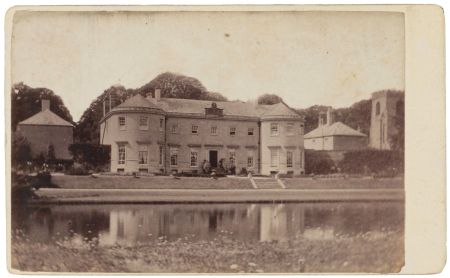
Kirkby Hall [Grade II*, NHLE: 1295737]
Known as both Kirkby Hall, and Kirkby Fleetham Hall, this is situated at SE 281 956. The main building is mid to late 18th century, with later 19th and 20th century additions and alterations (Figure 13).
Former Stable Block
Stable block and yard at SE 281 958, of 18th century date. Shown on the 1782 survey and later maps to the north of the church and current walled garden, now converted to housing (Figure 3).
Icehouse (NYHER MNY 14536)
An icehouse is first shown in 1891 in David’s Wood, to the north west of the Hall & church at SE 279 958 (Figure 12). It may well date from earlier; it was still in existence in 1957.
The icehouse is described by Tweedy (1967, 23-4): 'At the bottom of the bank built under the clay bank is the old Ice House which contained a brick built pit or well eight feet deep, this pit was filled with ice in the winter led by horses and carts from ponds on the estate'.
Ornamental Bridge
A route across the lake at its southern end is depicted in the painting of the c. 1750s (Figure 1), and also in the earliest cartographic evidence on the 1782 plan of Kirkby Hall Farm in the William Lawrence survey at SE 281 956. It is first named as a footbridge on the 25” OS map surveyed in 1891 (Figure 10). The current stone bridge is believed to be of 18th-century date, perhaps remodelled.
Church of St Mary [Grade II*, NHLE: 1150928]
The church lies immediately to the north of the Hall at SE 281 957.
Former Garden Buildings within and along the woodland terrace
From historic map evidence dating between 1782 and 1957, five former garden buildings can be located within, and along, the woodland terraces to the west, south and south east of the Hall (Figure 4). Variously referenced as summer houses and temples, no trace of any of these former garden buildings has been found on the ground. Tweedy (1967, 22-3), refers to there being four or five summer houses “spaced out to the end of the wood near Hooker Hill, all of different design and material”. The evidence for each is discussed individually below.
Former Garden Building at north end of Beeman’s Bank, above Hook Carr Hill Farm
The northernmost of the five garden buildings, this was located at SE 275 958. It can first be seen on the map of Davelle Farm within the 1782 survey of William Lawrence, within Beeman’s Bank woodland above Hook Carr Hill Farm (NYCRO Z.1641). It appears to have been the latest surviving of all the former garden buildings, still being depicted on the 1957 Ordnance Survey map. At this later date, it is shown as a rectangular structure, whereas on earlier Ordnance Survey map editions it is drawn as a circular structure, with a path leading to it and around it off the main route through the woodland. It is the only one of the five buildings shown on the 1848 map (NYCRO M120).
This garden building is mentioned by Tweedy (1967, 23) as housing an old man, George Dobson, who used to sleep in a kind of attic in the roof and do occasional work for neighbouring farmers, and who died in 1870.
Former Garden Building at north end of David’s Wood
Located at c. SE 279 958, this can first be seen on the map of Kirkby Hall Farm within the 1782 survey of William Lawrence as a rectangular structure at the northern edge of David’s Wood, above the plateau on which stands the Hall and Church (Figure 3). It is also visible on the c.1811 map (NYCRO ZMI 74), but not on later maps. There are, however, two paths depicted on the 6” OS map surveyed in 1854 which converge at 90 degrees in the woodland near to this point, which suggest the former presence of something to be accessed in this vicinity (Figure 8).
Former Garden Building within ‘The Terrace’ woodland
This former garden building was located at SE 283 954 within The Terrace woodland at the highest point in the area, 52m AOD. It lay just to the east of the crossroads between the main carriageway through the woodland and the route leading down the bank towards the Hall and Church, to the north of where Kirkby Lane takes a ninety degree turn westwards. From this location it would have commanded fine views to the north-north-east out over the parkland and the lake, Hall and Church to the north west.
The garden building is first shown on the 1782 plan of Kirkby Hall Farm as a rectangular structure with a path leading to it (Figure 3); the path down to the Hall is shown in 1782 descending The Terrace from a point further to the north west than is depicted on the c.1811 and later maps. The building is shown similarly on the 6” OS map surveyed in 1854 and the 25” OS map surveyed in 1891 (Figures 8 & 10). It seems to have disappeared by 1911.
It is likely that this is the garden building depicted in the paintings of Nebot (Figure 1) and Halfpenny, and the early 19th century engraving from the gentleman’s almanac (YML CY/MP/TOP/K/9/1).
Former Garden Building within Kirkby Wood
This former garden building was located within Kirkby Wood, a short distance to the south east of 4.7.6.3 (see above), at SE 28634 95207. It may have been a later addition to the designed landscape as it is not shown in 1782 (NYCRO Z.1641). It does appear on the 6” OS map surveyed in 1854, as a rectangular structure, and on the 25” OS map surveyed in 1891 as a circular structure with a short path leading to it off the main carriageway through the woodland. It may have disappeared by 1911.
Former Garden Building within Kirkby Wood, west of West Lowfield Farm
This is the southernmost of the five former garden buildings, located at SE 28974 94946 in Kirkby Wood, west of West Lowfield Farm.
It is first shown in 1782 (NYCRO Z.1641) as a rectangular structure, accessed by a path a short distance off the main carriageway through the woodland. It is also depicted c. 1811 (NYCRO ZMI 74), and is the only one of the garden buildings to be depicted on the 1838 Tithe Map (NYCRO T). There is also a path just to the south of the structure which leads down off the wooded bank down to the farm complex. Although not shown in 1848 (NYCRO M120), it is depicted on both the 6” and 25” OS maps, surveyed in 1854 and 1891 respectively, as a square structure. It is not, however, shown on later editions of OS map, by which time it seems to have disappeared.
This garden building is mentioned by Tweedy (1967, 22-3) as being a short distance from a row of beech trees with seats around them, which were located a few hundred yards further on from the former lodges at the south-east end of the village.
Gardens and pleasure grounds
To the north and east of the Hall were areas of gardens and pleasure grounds. Whilst early evidence for these is limited, they are described in both a newspaper article of 1937 and a sale catalogue of 1968.
In the Yorkshire Post, 1937: T
There are two herbaceous borders, one backed by the wall of the kitchen garden and the other running through the kitchen garden, both being planned with such skill and artistry that they show no sign whatsoever of having been planned, but appear merely to have grown naturally into a perfectly harmonious colour scheme. The plants used in this border are not unusual, but each is the best of its kind and each is grown to perfection. Outstanding among them is a giant eremurus, the flower spikes of which reach ten feet in height. Next come the delphiniums in a wide range of blues, then the yellow verbascum, blue and white campanulas, the exquisitely graceful sidalcea, peonies, lupins and all those other plants which make the herbaceous border such an essential feature of the typically English garden. It is impossible to describe such a border because its beauty lies not so much in the individual plants as in their cumulative affect, in the balance and contrast of colour, the variety of form and texture.
A modest stream runs through the wild garden, on through the rock garden, over stepping stones and under a rustic bridge, and finally broadens out into a shallow pond fringed with irises, primulas and kingcups. There are, however, one or two plants which deserve individual notice. The peonies are exceptionally well grown and free-flowering. They are old plants and have been undisturbed for at least fourteen years. Unlike most herbaceous plants, which should be lifted and divided every three years, the peony resents movement and if adequately manured will flower freely in the same place year after year. Here is also a very fine lily (Lilium pardalinum) which has large orange flowers spotted with purple. This is an excellent border plant being perfectly hardy, tall and showy. It seems to spread rapidly.
The 1968 sale catalogue describes them as: 'The delightful gardens are laid out mainly on the east side of the House and include: rose borders, lawns, many varieties of shrubs, attractive ornamental lake and streams with stone bridge leading to the Park, which is divided from the Gardens by a Ha-ha wall' (NYCRO K).
At the time of a site visit in November 2017, the immediate area to the south east of the Hall contained an area of clipped yew and a large Wellingtonia. There is also a large horse chestnut to the west of the Hall.
Terraced Lawn
This is an area of lawn immediately in front of the Hall to the east. In historic photographs of the Hall, there are rose beds here. The Yorkshire Post article of 1937 describes this area: “In front of the house there is a semi-circular lawn broken by beds of roses, each bed being reserved for one particular variety, as is the custom nowadays. It is becoming more and more difficult to select the best varieties of roses from the several thousands which are now offered by nurserymen, but those grown here – Étoile de Hollande, a deep crimson, Angèle Pernet, orange yellow, Else Poulsen, a semi-single pink of delicate form and colouring - are certainly among the best. This lawn is flanked by a deep border of peonies backed by tall delphinium”.
Ha-Ha
Forming the eastern boundary to the terraced garden to the east (in front) of the house, with retaining walls at either end to north and south, and central steps leading down to the lakeside below. Depicted on the 25” OS map surveyed in 1891, but likely to be of an earlier date (Figure 10).
Ha-Ha
Running along the western boundary of the parkland, to the east of the lake, shown as a boundary on the 6” OS map surveyed in 1854 (Figure 8).
Ha-Ha
Mentioned in 1968 estate sale catalogue as being to the west of the Hall,
Rock Garden
On the basis of historic map evidence, the rock garden is presumed to post-date 1889 when the Courages purchased the estate, and be present by 1911. Its creation appears to have removed the upper section of the lake created by William Aislabie. There are changes to the course of the stream and lake which can be seen on the 25" OS map revised in 1911 which may relate to the construction of the rock garden (Figure 12).
The rock garden was certainly in existence by 1937, when it is described in a Yorkshire Post newspaper article of that year:
Those who visited these gardens when they were previously opened in May will remember how delightful the rock garden then was and they may wonder whether it could possibly be as lovely at any other time of the year. They need have no doubts about visiting it again. True, the later alpines are all Spring-flowering, and such treasures as Omphalodes terna, Wahlenbergia and Androsace sarmentosa have had their too-brief hour of glory and departed. But their place has been taken by a host of other things which, if less delicate, are certainly not less lovely. The rock roses, for example, make a splash of brilliant vermillion, contrasting well with the blues and whites of numerous campanulas. There are also many noble Asiatic primulas, meconopses and foxgloves.
The present owners have restored this area of the garden, using rocks recovered when the lake was dredged (pers comm.)
Kitchen garden
The walled kitchen garden which lies immediately to the north of the church, north of the Hall, centred at SE 281 957 is presumed to date to no earlier than the late 18th century when the former vicarage was demolished and rebuilt on a site within the present village of Kirkby Fleetham (see 3.3.3 above).
A further, slightly smaller garden is located adjacent to the north, to the east of the former stable block. This is first shown as an orchard on the 6” OS map surveyed in 1854, which is also the first depiction of the area to the south as a formally laid out kitchen garden with perimeter and central paths (Figure 8).
The earlier, c.1811 map identifies the area of this larger walled kitchen garden as no.13, which the accompanying book of reference lists as ‘Old Vicarage &c’, its state of cultivation in 1813 being orchard (NYCRO ZMI 74). Tweedy (1967, 19) mentions that the vicar or priest lived on the site, or near, where 'now stands a summer house by its entrance to the kitchen gardens of the Hall'.
An Inventory of the Contents of Kirkby Fleetham Hall of December 1825 (WYAS WYL150/1766 (430/6)) includes one dozen peach glasses, light boxes for cucumbers and melons and a box for seeds.
During a site visit in November 2017, a hot wall was noted on the north side of the walled garden, which faces south and has a double wall and a boiler house behind (on the north side of the wall). Three of the four walls of the walled garden are made of handmade bricks, dating to before 1780. The fourth, eastern wall has been rebuilt in stone. There are currently planting beds arranged along the east-west axis, and a garden building against the northern wall. There are entrances from the east and west, that from the east being through an iron gate leading out to the lawns and lake. To the west, the entrance is through a small lobby. This is a single-storey, internally rendered, brick-built structure with fireplace, which is attached to the exterior of the western kitchen garden wall. The brick garden wall is breached by an arched opening, or aedicule, framed either side in stone by a pair of Doric columns with architrave, with that on the interior, eastern side surmounted by a pediment. The brick wall behind is a little higher, similarly shaped, flanked by two stone ball finials. These features are visible in a photograph taken in the 1980s (Figure 14) but, at the time of the site visit, were covered in ivy.
When this entrance was created is unknown. It could be postulated that these Neoclassical features may have been reused from one of the former garden buildings/temples up on the woodland terrace, or some other structure?
The kitchen gardens are described in the 1968 sale catalogue.
Glasshouses
These are first shown, shaded in blue, at SE 281 958 on the 25” OS map surveyed in 1891, to the east of the stables on the northern boundary of the smaller, kitchen garden/former orchard, immediately south of the stream as it turns through ninety degrees from west-east to north-south (Figure 10). By 1911, these glasshouses have been extended to the west (Figure 12).
Potting Shed, Bothy or Boiler House
A building on the northern side (exterior) of the northern (south-facing) wall of the kitchen garden to the north of the church is first shown at SE 2813 9579 on the 6” OS map surveyed in 1854, and appears to have been extended in size by 1891 (Figures 8 & 10). This could have included a potting shed and bothy, as well as a boiler house for a hot wall.
Park and plantations
Former Parkland
Assumed to have been created initially in the 1740s to accompany the new house built by William Aislabie, the parkland lay to the east (in front of) the Hall. This parkland was similar in form and extent between 1782 and the 1950s, with minor modifications to field boundaries and some additional tree planting in the north-east corner (Park Plantation appears between 1891 and 1911, Figures 9 & 11). The area is now mainly in arable cultivation, with a belt of plantation along its western boundary, screening the Hall from the fields beyond. Archaeological evidence of former ridge and furrow indicates that this area was formerly part of the medieval open field system. Ordnance Survey maps from the 6” surveyed in 1854 show a footpath crossing the parkland from north west to south east (Figure 7). The 1968 sale catalogue refers to an 8 furlong gallop in the park (NYCRO K).
Beeman’s Bank Plantation
Centred at SE 276 956, this is the westernmost arm of woodland, to the east of Hook Carr Hill, which was in existence by 1782 (Figure 3).
David’s Wood Plantation
Centred at SE 279 956 to the west of the Hall and church, this was in existence by 1782 (Figure 3). At the time of the 1968 auction catalogue, the woodland at Beeman’s Bank and David’s Wood, Lot 6, is described as extending to about 12.485 acres, containing valuable commercial oak and mixed hardwood timber and softwood plantations; larch, sycamore, oak, elm and ash (NYCRO K).
The Terrace Plantation
Centred at SE 283 954 to the south and south east of the Hall, this was in existence by 1782 (Figure 3).
Kirkby Wood Plantation
Centred at SE 289 949 to the east of the Terrace and west of West Lowfield Farm, extending south to Lowfield Lane, this was in existence by 1782 (Figure 3).
Water
Lake
Situated immediately in front of the Hall, on its eastern side at SE 281 956, the lake was created by William Aislabie in the 1740s/50s. There are references in the Studley accounts (see 3.3.2 above) to the making of the reservoir in 1743 and later, in 1754, to requiring oak for the top tree of the dam and the setting up of said dam and its clay walls in 1755.
Linear in form, the lake lies between the Hall and the eastern parkland, formed from the stream which feeds it from the north, and crossed by a footbridge to the south. When viewed from the west, the reflection of the Hall can be seen in the lake. At the time of the Nebot painting in the 1750s, there is a circular pool at the southern end of the lake, beyond the southern end of the Hall, although this pool is less clearly depicted in the 1782 survey plan of Kirby Hall Farm and has disappeared by the map of c. 1811 (Figure 3). The lake retains its elongated form until the 25” OS map surveyed in 1891 (Figure 10). By 1911 it appears that under the ownership of the Courages the lake, whilst still elongated in form, has taken on a more irregular shape, as has the stream to the north, presumably at the time of the creation of the rock garden (Figure 12, see also 4.8.5 above). Furthermore, at this date, waterfalls are shown at the northern and southern ends of the lake. In 1859, Whellan (1859, 366) refers to the fish ponds in front of the house, formed by a clear stream.
Stream
The 1782 survey plan of Davelle Farm appears to show the stream, which currently encircles the Hall and church, on a different alignment to its present course, heading northwards from a point north of the former stable block along the eastern side of Kirkby Lane leading north to the River Swale (NYCRO Z.1641).
Whereas the stream currently feeds the lake to the east of the Hall and curves from the north of the lake to the west and southwards around David’s Wood and along the northern foot of Beeman’s Bank, on the 1782 survey plan of Davelle Farm, the stream takes a more northerly course. It is aligned westwards from the dovecot, then takes a semi-circular curve slightly to the south along what is now the parish boundary with Killerby.
This stream feeds the lake and circular pool shown on the Nebot painting (Figure 1), and the 1782 survey plan. On later editions of the Ordnance Survey maps, several weirs and waterfalls are marked along the stream to east and south east of the Hall. These are presumably to control the flow and level of the water, and also to create points of interest along its course (Figures 10 & 12).
Well Head
This is shown on the 25” OS map surveyed in 1891 at SE 2804 9581, south of Hall Cottages and west of the former stables (Figure 10).
Well Head
This is shown on the 25” OS map surveyed in 1891 at SE 2816 9557, at the foot of The Terrace woodland bank (Figure 10).
Books and articles
Askwith, E. & Harrison, B.J.D. 1975. ‘The Medieval Landscape’, in Journal 2, NYCRO Publications no. 4
Barber, W. 1996. Kirkby Fleetham and the Aislabies: 1724-1845. A survey of the documentary evidence arranged in chronological order, unpublished research paper.
Chetwynd-Stapylton. H.E. 1884. ‘The Stapeltons of Richmondshire’,in Yorkshire Archaeological and Topographical Journal Volume 8, pp.67-116. Leeds: Yorkshire Archaeological Society.
Chetwynd-Stapylton. H.E. 1897. The Stapeltons of Yorkshire, Being the History of an English Family from Very Early Times. London: Longmans, Green & Co.
Chris Blandford Associates. 2011. North Yorkshire and York Landscape Characterisation Project. Unpublished report for North Yorkshire County Council https://www.northyorks.gov.uk/sites/default/files/fileroot/Environment%20and%20waste/Conservation/North_Yorkshire_and_York_landscape_character_assessment_report.pdf [consulted 18 February 2018]
Eyres, P. 1981. Mr. Aislabie's gardens: three North Yorkshire gardens landscaped during the 18th century by John Aislabie (1670-1742) and his son, William (1700-1781). Bradford: New Arcadians.
Faull, M.L. & Stinson, M. (eds) 1986a. Domesday Book Yorkshire (Part One). Chichester: Phillimore
Faull, M.L. & Stinson, M. (eds) 1986b. Domesday Book Yorkshire (Part Two). Chichester: Phillimore
Gee, E.A. 1968. Kirkby Fleetham Hall (NYCRO CRONT 778)
Hambleton District Council 2016 Hambleton Local Plan: Settlement Character Assessment for Kirkby Fleetham (page 99-107), unpublished report.
Harris, J. 1979. The Artist and the Country House, A history of country house and garden view painting in Britain 1540-1870. London: Sotheby Parke Bernet.
Kelly, E.R. (ed.) 1879. The Post Office Directory of the North and East Ridings of Yorkshire with the City of York. London: Kelly & Co.
Land Use Consultants. 2016. Hambleton Landscape Character Assessment and Sensitivity Study.
Madden, F.; Bandinel, B and Nichols, J.G. 1838. Collectanea topographica et genealogica, Volume V. London: J. B. Nichols and Son.
Newman, M. 2015. The Wonder of the North: Fountains Abbey and Studley Royal. Woodbridge: The Boydell Press.
Page, W. (ed.) 1914. A History of the County of York, North Riding. Volume 1. The Victoria History of the Counties of England. London: Victoria County History.
Reid, M. 2011. The Aislabie Walk: A journey through picturesque landscapes – Studley Royal, Laver Banks, Hackfall. The Woodland Trust: Grantham
https://www.woodlandtrust.org.uk/mediafile/100048013/aislabie-walk-leaflet.pdf [consulted 18 February 2018]
Ripon Historical Society & Ripon, Harrogate& District Family History Group. 1991. The Hearth Tax List for the North Riding of Yorkshire. Michaelmas 1673. Part Two. Allerton, Gilling East, Hallikeld & Hang East Wapentakes (NYCRO CRONT 1453).
Stanley Price, M.J. (ed) 1955. Yorkshire Deeds Volume X, YAS Record Series Volume CXX for the year 1953 Leeds: Yorkshire Archaeological Society.
Tweedy, A.O. 1967. A History of Kirkby Fleetham Parish and Tales That Were Told.
Whellan, T. & Co. 1859. History and Topography of the City of York: The North Riding of Yorkshire. Beverley: John Green.
Young, A. 1771. A Six Months’ Tour through the North of England, Volume 2. London: printed for W. Strahan & W Nicholl.
Primary sources
British Library [BL]
1577 Christopher Saxton – Eboracencis comitatus f.61 (Map of Yorkshire)
Add MS 36395, fol 164 ‘South East View of Kirby Fleetham, Yorkshire. The Seat of Mrs Lawrence 1816-1817’, John Buckler pencil sketch
Add MS 36395, fol 165 ‘1816-1817’, John Buckler pencil sketch, unlabelled, showing South West View of Kirby Fleetham, Yorkshire
Centre for Local Studies, Darlington Library (DL)
E730009127 Design for a conservatory for J Bolland of Kirkby Fleetham Hall, Bedale, taken from page 44 of the Richardson and Ross (1855-1862) design book.
North Yorkshire County Record Office (NYCRO)
K [NRCC/LV] Kirkby Fleetham Estate sale catalogue, 04 April 1968
M 120 Copy Plan of the Parish of Kirkby Fleetham with part of Catterick and Langton, in the County of York, including the estate of Harrie Edmund Waller Esq. 6 chains to an inch, 1848
MIC 1919/196-204 John Speed, Map of the North and East Ridings of Yorkshire, 1610
MIC 1919/205-209 Johan Blaeu, Map of North Riding of Yorkshire, 1648
MIC 1919/212-217 John Cary, Map of the North Riding of Yorkshire, 1803
NRRD Vol. HI, p.220, no.279 Memorial of probate of the last will and testament of Elizabeth Sophia Lawrence, Registered 26 January 1846
NRRD Vol. KT, p.435, no.735 Memorial of probate of the last will and testament of Henry Edmund Waller, Registered 22 January 1870
NRRD Vol. 26, p.862, no.377 Memorial of an Indenture of Conveyance in Fee between Edmund Waller and Edward Courage, 22 June 1889
PR/KRF 4/1 Kirkby Fleetham Parish Account Book containing terrier of 1708 and court leet pains c.1710, 1711-1768
PR/KRF 7/3 Correspondence between Ray Osmotherley and the Revd Jowitt relating to Salkeld Osmotherley, vicar of Kirby Fleetham 1729-1763, 28 October 1965
QDP (M) 80/1 Liverpool, Manchester and Newcastle-upon-Tyne Junction Railway, North Riding of the County of York. Alterations of Main Line from Newton-le-Willows to Cowton. Plan No. 4, 1846
QDP (M) 80/2 Liverpool, Manchester and Newcastle-upon-Tyne Junction Railway: Book of Reference to the plans of the Deviations of the Main Line, and of the Hawes Branch, deposited herewith, 1846.
T Kirkby Fleetham Tithe Map & Apportionment, 1838/9
Z.1642 Survey of an Estate belonging to William Lawrence Esquire lying within several parishes of Kirkby, Catterick and Langton in the County of York. Taken in 1782 by W Downing
ZDU Thomas Jefferys, Map of Yorkshire, 1771
ZDV John Tuke, Map of the County of York, 1787
ZMI 74 Plan of Kirkby Fleetham and Langton, no date, with watermark of 1811, c.1811, plus two books of reference to the above plan, one arranged in numerical order; the other arranged according to tenancies and including valuations, with notes on cultivation in 1813, plus letters of 1847 concerning railway, undated, c.1813
ZMI 75 Plan of Kirkby Fleetham and Langton, undated
ZQH 6/66 C. & J. Greenwood, Map of the North Riding of the County of York, from an actual survey made in the years 1817 & 1818, 1834
The National Archives, Kew (TNA)
PROB 11/226/631 Will of Mathew Smelt of Kirkby Fleetham, Yorkshire, 28 September 1653
PROB 11/1077/439 Will of William Aislabie of Studley Royal, Yorkshire, 30 May 1781
Private Collection
Painting of Kirkby Fleetham, 1750s by Balthasar Nebot (c.1700 – c.1770) (Illustrated in b/w in Harris 1979, 196, Plate 198 and Newman 2015, 176, Fig 135)
Two Paintings of Kirkby Fleetham Hall, undated, attributed to Joseph Halfpenny
Carte de visite of Kirkby Fleetham Hall, c.1860s-1870s
West Yorkshire Archive Service, Leeds (WYAS)
Vyner of Studley Royal, Family and Estate Records (WYL150)
1766 (430/6) Bargain and Sale: Elizabeth Sophie Lawrence to William Bruere, Kirkby Fleetham Hall and lands, 6 December 1825.
5508 (287) Accounts of Estate Expenses kept by Mr Broadbelt for John Aislabie, 1724-50
5511 (301/7) Draft Account Book of the receipts and disbursements of William Aislabie, 1732-1735.
5523 (T/32/2) Account Book of estate accounts of Miss Lawrence, 1819-1825
5524 (C.64/1) Account Book of estate accounts of Miss Lawrence, 1825
5525 (C.64/2) Account Book of estate accounts of Miss Lawrence, Kirby Fleetham, 1830
5526 (C.64/6) Account Book of estate accounts of Miss Lawrence, Kirby Fleetham, 1832
5527 (C.64/3) Account Book of estate accounts of Miss Lawrence, Kirby Fleetham, 1841
5574 (484/2) Index of Letters written concerning Miss Lawrence’s estates in Studley, Ripon, Kirkby Fleetham; Leicestershire & Lincolnshire, 1796-c.1813
5603 (472) Abstracts, Extracts and Schedules of Deeds relating to estates belonging to the late Miss Lawrence at Studley, Ripon, Kirkby Fleetham and Craven. c.1870
5619a (286) Bills and Vouchers relating to work done at Studley Royal, mainly to John and William Aislabie, 1726-1738. Bills and vouchers, 1702-62, Bundle B, part 2, Doe to Aislabie, 3 & 9 May 1754
5638 (301/7) Various loose papers and accounts of John Aislabie, 1703-1737
5639 (302/5) Various loose papers and accounts of John Aislabie, 1725-1750
5948-9 (278/2) Post-nuptial settlement by lease and release of William Aislabie and Lady Elizabeth his wife, 21/22 June 1728
Virtual Library of Bibliographic Heritage, Spanish Ministry of Education, Culture and Sport [VLBH]
John Warburton A New & Correct Map of the County of York in All its Divisions, 1720
York Minster Library (YML)
CY/MP/TOP/K/9/1 Engraving of Kirby Fleetham, Yorks. Seat of Mrs Lawrence ‘APRIL’ from the Edward Hailstone Collection, undated, possibly from a gentleman’s almanac or diary.
Maps
Ordnance Survey 6” 1st edition, surveyed 1854, published 1857
Ordnance Survey 6” 2nd edition, surveyed 1891, published 1895
Ordnance Survey 6” Revised edition, revised 1911, published 1919
Ordnance Survey 25” 1st edition, surveyed 1891, published 1893
Ordnance Survey 25” 2nd edition, revised 1911, published 1913
Ordnance Survey 25” 3rd edition, surveyed 1927, published 1928
Newspapers and magazines
The Leeds Intelligencer 09 August 1845
The Yorkshire Gazette 27 September 1862
The York Herald 30 May 1877
The Yorkshire Post 09 July 1937
The Leeds Mercury 11 February 1939
Gentleman’s Magazine 1845, Pt.II; (October) pp.420-423
Figure 1 - Painting of Kirkby Hall and church in their landscape setting, attributed to Balthasar Nebot, 1750s. Private collection
Figure 2 – Extract from Thomas Jefferys’ map of Yorkshire, Plate 2, 1771. Reproduced by permission of the North Yorkshire County Record Office (ZDU)
Figure 3 – Plan of Kirkby Hall Farm from 1782 Survey of an Estate belonging to William Lawrence Esq., with inset detail of area around the Hall. Reproduced by permission of the North Yorkshire County Record Office (Z.1641)
Figure 4 – Vertical aerial image showing area of designed landscape, with superimposed red circles indicating the locations of former garden buildings along the woodland terrace. Google Earth image © Infoterra Ltd & Bluesky (2019)
Figure 5 – Tithe map of Kirkby Fleetham, 1838, showing access from woodland terrace down to Kirkby Hall and church. Reproduced by permission of the North Yorkshire County Record Office (T)
Figure 6 – Plan of Kirkby Fleetham with part of Catterick and Langton, including the estate of Harrie Edmund Waller, 1848, showing changes to the arrangement of Hall and outbuildings. Reproduced by permission of the North Yorkshire County Record Office (M 120)
Figure 7 – 1st ed OS 6” showing the extent of designed landscape at Kirkby Fleetham, surveyed 1854, published 1857. Reproduced by permission of the National Library of Scotland
Figure 8 – 1st ed OS 6” showing close up of area immediately around Kirkby Hall, surveyed 1854, published 1857. Reproduced by permission of the National Library of Scotland
Figure 9 – 2nd ed OS 6” showing reduced area of parkland, surveyed 1891, published 1895. Reproduced by permission of the National Library of Scotland
Figure 10 – 1st ed OS 25” showing arrangement of stream and lake to the east of the Hall, surveyed 1891, published 1893. Reproduced by permission of the National Library of Scotland
Figure 11 – 6” Rev OS map showing additional planting around the edges of the parkland, revised 1911, published 1919. Reproduced by permission of the National Library of Scotland
Figure 12 – 2nd ed OS 25” showing changes to stream and lake to the east of the Hall, revised 1911, published 1913. Reproduced by permission of the National Library of Scotland
Figure 13 – Carte de visite showing the east front of Kirkby Hall and St Mary’s church tower from across the lake, undated, c. 1860s-1870s. Private collection
Figure 14 – Photograph of the interior view of the western entrance to the walled garden in the 1980s showing Neoclassical aedicule. Ray Blyth


