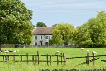
Linden Grange [Grove] is a late 19th/early 20th century designed landscape of around 97 acres (39 hectares) that retains much of its original planting, although the parkland itself is much reduced through building and reversion to agricultural use. Other features remain such as the avenue from the Lodge that gave the site its name and the pond to the south of the house.
In the mid-18th century the main building, now known as Linden Grange, was constructed on a site called ‘Tunstall Ground’ to the south west of the village of Hutton Rudby. By 1783, this was owned by David Simpson and inherited by his grandson, Benjamin David Suggitt, that year (Graves 1808, 178). On the death of Suggitt in 1823, it passed to his nephew, George Merryweather, the son of his half-brother, also George. When Merryweather married in 1826, he was described as ‘of Suggitt Grove’, so the property had changed its name but by 1839, it was called ‘Linden Grove’ (NYCRO MIC 1795/83). This name change may have been due to the avenue of lime trees leading from the Lodge.
Merryweather, a doctor practising in Whitby, appears not to have lived at the property. Instead he rented it out to a succession of tenants. In 1839 it was the local vicar, Robert Barlow and his family who occupied it (NYCRO MIC 1795/83), as there was no glebe house in the village. Barlow then moved to the newly built Vicarage near to Linden Grove in 1844. Merryweather put the property up for sale in 1845 (Yorkshire Gazette, 10 May). The advertisement gives the following description:
Linden Grove, in Cleveland
To be sold by Private Contract
All that Messuage or Mansion House called Linden Grove, situate near Hutton Rudby…with the Gardens, Shrubberies, Coach-Houses, Stables and other Out-Offices thereto belonging, now in the Occupation of Colonel Mac Bean. And also all those several Closes or Parcels of very superior Meadow and Pasture Land, adjoining the aforesaid Premises…The above property is in a Ring Fence, contains altogether 111a 3r 35p or thereabouts…
The Mansion, which is most beautifully situated in the midst of a fertile and romantic district…The Garden and Shrubberies are stocked with Thriving Fruit Trees and Evergreens, and the Grass Land, which is divided into conveniently-sized Fields, is well watered and fenced.
Whether it was sold is not clear as Colonel Forbes MacBean is still the occupant in the 1851 census. By the next census of 1861, Dr Edwin Wilson is listed as living at that address and again when it was put up for sale in 1865 (The York Herald, 8 April). The size of the estate had reduced though to 98 acres with ‘about five acres, which consist of Garden, Pleasure Grounds and Plantings’. It was not sold and was available to rent again in 1871 (The York Herald, 13 May). The occupant in the 1881 census was Thomas English Pyman, who was a shipowner from Hartlepool. There is no-one listed in the 1891 census.
George Merryweather had died on the 4 November 1870 and most of his family had emigrated to America, so his heirs sold the house and surrounding land of 97 acres to George Young Blair, of nearby Drumrauch Hall. Blair’s daughter, Mary, moved in with her husband Percy Sadler after 1891 and took possession following her father’s death in 1894. Percy and Mary started to remodel the landscape, converting the fields into parkland as far south as Potto Station and made a new entrance in the south. They also planted woodland around the perimeter and built an aviary.
Mary Blair continued to live there after her husband died in 1906 until her death on 5 December 1935. It was then occupied by her daughters, Winifred Rachel Blair and Katherine Mary Roche. Winifred had left by the time she died in Ambleside on the 3rd February 1951 but Katherine was living at Linden Grove at the time of her death on the 3rd September 1964. In the 1970s, the estate was divided and housing was built in the northwest corner of the parkland, with additional properties to the south.
Linden Grange lies 0.5 miles (0.8km) south of the village of Hutton Rudby and is on a slightly sloping site from north to south, with the main house at 71 AOD. The historic parkland covers about 97 acres (39 hectares) with its northern boundary being Belbrough Lane and its western boundary was Station Lane. It is bounded on the south by the stream, Potto Slack, and on the east by field boundaries from NZ 472050 to NZ 467059 (Figure 1).
The main house, Linden Grange, is listed Grade II and dates from the middle of the 18th century with some additions in the 19th century. The Lodge was constructed before 1839, together with the gardens, a small rectangular pond and plantations alongside the carriageway to the house (Figure 2). There was some perimeter planting in the northern part of the parkland by 1892 and the pond to the south of the house was extended to an irregular feature (Figure 3).
The final changes to the landscape were in place by 1911 (Figure 1). This included a new entrance from the road to Potto Station, with a carriageway that led north to the main house. As well as the extended parkland to the south and east, there was planting on the new perimeters with a large plantation on the southern boundary. The pond was also increased in size from 0.239 acres in 1894 to 0.689 acres by 1914.
Books and articles
- Graves, J. 1808. The History of Cleveland in the North Riding of the County of York. Carlisle: F. Jollie & Sons.
Newspapers
- The York Herald
- Yorkshire Gazette
Primary sources
North Yorkshire County Record Office (NYCRO)
- MIC 1795/83 - Hutton Rudby Tithe map, 1839
Maps
- Ordnance Survey 6” 1st edition, surveyed 1854, published 1857
- Ordnance Survey 6” 2nd edition, surveyed 1891/2, published 1895
- Ordnance Survey 25” 1st edition, published 1894
- Ordnance Survey 6”, revised 1911, published 1919
- Ordnance Survey 25” 2nd edition, published 1914
")


