Well-preserved example of a large landscaped park laid out in its present form in the late 18th century, typical of the work of Lancelot 'Capability' Brown who provided a plan for improvements in 1775.
Estate owners
In the 13th century the manor of Rise belonged to the Fauconberg family who sold it to Sir John Neville in 1372. When the estates of Richard Neville, earl of Warwick, were partitioned in 1475 the manor of Rise was assigned to his brother-in-law, Richard duke of Gloucester, later Richard III. It remained in Crown hands until 1628. The Bethells, who were sub-lessees from the late 16th century, when they moved to the East Riding from Herefordshire, purchased the manor in 1646 and by 1660 owned practically the whole township of Rise. (Kent, VCH Yorks ER VII, 331-2). The Bethell family still own most of the estate although the principal house, Rise Hall, has been sold.
The owner chiefly responsible for the landscaping was William Bethell, owner 1772-1799, but some improvements were probably carried out by Richard Bethell, owner 1814-1864
Early history of the site
The Fauconbergs had a deer park at Rise in the 13th century. The precise location of the medieval park is not certain, but earthworks in the vicinity of the site of Black Hall, the Fauconbergs’ manor house at the north-west corner of the present park, include a substantial bank that may relate to the former deer park. Black Hall had gone by the early 16th century and been replaced by a house on a different site. A plan of 1716 shows the Bethells’ house, which had 13 hearths in 1672, on the site of the present Rise Hall, set in modest formal gardens. At this date the park apparently included Rise Wood (in which deer are shown on the plan), an area to the south called the Laund (a name traditionally used for a grassy clearing within a deer park), and an area to the east of Rise Wood later known as Old Park. (Neave, Medieval Parks, 48-9) An avenue of trees apparently ran from the northern boundary across Blackhall (or Lodge) Field to the fishpond in Rise Wood, and there are traces of another avenue south-east of the fishpond.
Chronological history of the designed landscape
The park at Rise was landscaped in the 1770s. Rise Hall was rebuilt in 1815-20, and further improvements to the park were probably carried out around the same time.
1770s-1820s
A plan of the estate in 1762 shows some changes had already been made since 1716, when the deer were kept in the woods. By 1762 the area south of the hall was divided into two with a fenced deer park to the east and woodland to the west.
William Bethell inherited the Rise estate in 1772. In 1773 he refronted the hall and soon after began to extensive improvements to the grounds. In 1775 Bethell obtained from Capability Brown ‘A General Plan for the Alterations of the Place’. The only reference to this plan, which does not survive, is in Brown’s account book, and it is not known to what extent the landscape park that was created at this time followed his suggested plan. However, the present park bears all the hallmarks of a mature Capability Brown landscape, and it seems most likely he influenced its design. (Neave & Turnbull, Landscaped Parks, 58-9).
Around the time that Brown provided his plan for landscaping the grounds, William Bethell applied to divert the street that ran north of the hall a little further north. Moving the road gave the house more spacious surroundings. Further south 40 acres of acres of oak woodland in Rise Wood were cleared and taken into the park. An advert was placed in the York Courant, 14 March 1775, giving notice of the sale of 85 oak trees that had already been cut down, and 422 still standing that were due to be felled. Within this cleared area a second pond, ‘New Pond’, was created. Both ponds had circular islands. Along the boundaries on the eastern side of the park plantations were made, and clumps of trees were dotted throughout the enlarged park. In Rise Wood, a substantial portion of which remained, walks were made. Much of the planting was probably done for William Bethell, who died in 1799, but additional work on the landscape may have been carried out c. 1815-20 when Rise Hall was rebuilt.
Later changes
More clearance took place in Rise Wood in 1843, when 586 ash, 124 elm, 64 beech, 61 sycamore, 39 alder, 37 lime, 35 poplar, 27 chestnut and 14 birch trees in the wood and an adjoining plantation were put up for sale. (Hull Packet, 10 March 1843).
In 1856 Rise Hall was said to stand in ‘a fine park, beautifully ornamented with timber. About 300 head of deer occupy 130 acres; there are 120 acres of wood; and the fish ponds occupy 20 acres.’ (Sheahan & Whellan, York & the ER II, 428). The deer were dispersed at the start of the Second World War, when the parkland was temporarily ploughed up. (Neave, Medieval Parks, 48). In other respects there has been little change since the mid 19th century.
Location
Rise Park lies 9 miles east of Beverley, and 5 miles south-west of Hornsea.
Area
About 345 acres (140 ha) (includes parkland, plantations, Rise Wood and pleasure gardens). Of this area Old Park 32.4 acres (13 ha) is now in cultivation.
Boundaries
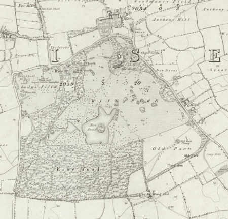
The historic parkland, including Rise Wood, is bounded by roads on three sides. On the west side, beginning at South Lodge, the B1243 runs north past Rise Wood and Blackhall field; it then bends to run east as far as the entrance lodges to Rise Hall. At this point the road forming the northern boundary of the park ceases to be part of the B1243 (which goes north at this point) but continues as a minor road, running past the church of All Saints, then alongside Church Walk Plantation to East Lodge. It then runs south along the eastern boundary of the park past Park Farm and the Round House. The plantation called Dawson’s Belt may be regarded as part of the southern limit of the historic parkland (although the area to the north of the plantation, part of ‘Old Park’, is now under cultivation). The southern edge of Rise Wood marks the rest of the southern boundary.
Landform
Rise Park is in the centre of the low lying plain of Holderness. The land is gently undulating between 15 m and 20 m AOD.
The bedrock is chalk (Flamborough Chalk Formation), the superficial deposits are boulder clay (Devensian Till) through much of the area with sand and gravel in the north east section.
Setting
Rise Park lies in East Riding Landscape Character Type 19 Holderness Open Farmland, subsection 19A Rise Parkland. The well-wooded park is in great contrast to its surroundings, an extensive area of largely flat open arable farmland with few trees.
Entrances and approaches
Pair of stone lodges (listed Grade II)
They stand on the road that forms the northern boundary of the park with curving screen walls, ornamental iron gatepiers and elegant wrought-iron gates and railings. They mark the beginning of the long, curving carriage drive to Rise Hall (no longer used as the entrance drive to the house, which is now in separate ownership from the park). The square lodges were almost certainly built c.1818 (when the Rise Hall was under construction) to the designs of Watson & Pritchett. (Pevsner & Neave, York and the ER, 659). They have pyramidal slate roofs and to the front a recess with pairs of Ionic columns.
East Lodge
A neat Victorian red brick cottage with a slate roof, stands on the north side of the short drive that leads from the lane at the north-east corner of the park to the stables at the back hall. (Rise Hall is now accessed via this drive.)
South Lodge
At the south-west corner of Rise Wood, stands alongside a track that leads through the woodland, between the fish ponds and through the park to the hall. It is an attractive stuccoed cottage of c. 1830, with overhanging eaves and a rustic veranda. Gothic doorway and hoodmoulds over the windows, some of which have leaded lights. (Pevsner & Neave, York and the ER, 659). It was previously known as Wood Cottage (OS plans 1855; 1910)
Round House (listed Grade II as South Lodge Cottage)
On the eastern boundary, opposite Park Farm. Built c. 1820, it is octagonal, rather than round, and has a five-sided wing to the rear. Brick, with an overhanging slate roof with central stack, and Tudor hoodmoulds to the doors and windows. (Pevsner & Neave, York and the ER, 659). A track originally led from the lodge to Rise Wood (OS plan 1855) but this no longer exists, and that park of the former parkland is now under cultivation.
Principal buildings
Rise Hall Listed Grade II*
The present hall, an austere Neoclassical house, was built for Richard Bethell, 1815-20, and was almost certainly designed by Watson & Pritchett. Faced in ashlar, the main house is rectangular, of two storeys. The principal (west) façade has a portico with four giant columns with pediment. (Pevsner & Neave, York and the ER, 659) The hall is now in separate ownership from the park.
Stable and coach house Listed Grade II
The stable and coach house lie to the north of the hall, and are arranged around an open courtyard, now filled in. They are built of brick with a hipped slate roof, and date from the late 18th century. (Pevsner & Neave, York and the ER, 659)
Gardens and pleasure grounds
At Rise the late 18th century parkland, rather than formal pleasure gardens, provides the setting for the hall. Early Ordnance Survey plans shows trees planted close to the house, as now. To the east of the hall is the ‘Garden Plantation’ with walks running through it. A conservatory or greenhouse formerly stood to the east of the stables.
Kitchen garden
The former kitchen garden lies north of the hall and parkland, on the opposite side of the road. It is shown in this location on the mid 19th century Ordnance Survey plan, and in more detail on the 1910 Ordnance Survey plan. There were glasshouses in the western section.
In 1999 a small commercial firm, Slater Organics, took over the abandoned kitchen garden, and it is now used for growing organic vegetables.
Park and plantations
Open Parkland
There has been little change to the parkland since it was mapped by the Ordnance Survey in the mid 19th century.
Woodland and other plantations
To the south and west of the open parkland lies Rise Wood, an ancient wood that was once larger. The rest of the park has narrow plantations along its boundaries. North of the hall is Church Walk Plantation, with Garden and Park Plantations on the eastern boundary, and Dawson’s Belt (formerly Old Park Plantation) at the south-east corner.
The plans below show the open parkland, Rise Wood and the boundary plantations in the mid 19th and late 20th century.
Water
Fish ponds
The western pond, ‘Old’ pond, is shown on a plan of 1716, and may in part have been a decoy. By the mid 19th century the icehouse stood just to the north-east of it. The larger eastern pond, ‘New Pond’, is part of the landscaping carried out after William Bethell inherited the estate in 1773. Each has a small island.
Books and articles
G.H.R. Kent (ed.), Victoria County History, Yorkshire E. Riding, VII, 2002
D. Neave & D. Turnbull, Landscaped Parks and Gardens of East Yorkshire, 1992
S. Neave, Medieval Parks of East Yorkshire, 1991
N. Pevsner & D. Neave, Buildings of England: Yorkshire, York and the East Riding, 1995
J.J. Sheahan & T. Whellan, History and Topography of York and the East Riding, II, 1856
Primary sources
Family and estate papers of the Bethell family of Rise (East Riding Archives and Local Studies [ERALS], DDRI)
Newspapers
Hull Packet
York Courant
Maps
Plan of Rise, 1716 (at Rise Park)
T. Jefferys, Yorkshire, published 1772 & 1775
A. Bryant, East Riding, surveyed 1827-8, published 1829
Ordnance survey maps published 1855-2012
, surveyed 1767-1770 & published in 1800. McMaster University Library, ref. RMC_4336 (CC BY-NC 2.5 CA)")


")