Stapleton Park once had a mansion designed by John Carr, extensive kitchen gardens, pleasure grounds, lake and a landscape park of 182 hectares (450 acres). The creation of the designed landscape here may be the work of Lancelot Brown, Richard Woods and possibly Thomas White. Brown submitted a plan in 1782 just before his death, which is now lost. Between 1763 and 1765, Woods is recorded as doing work there, including landscaping the carriageways through the estate. In 1783 and 1784, White’s accounts show payments to him by Stapleton’s new owner, Lord Stourton. Without further evidence, it is impossible to say whether any of these three important designers were responsible, however features of the walled kitchen garden are very similar to others known to be designed by Richard Woods. The designed landscape remains largely intact today, despite the demolition of the mansion in the early 20th century.
Estate owners
In the Domesday Book, the lord of the manor of Stapleton in 1086 was Gilbert, whose descendants were later named as ‘de Stapleton’. Robert de Stapleton (fl 1255) was the last male owner as his daughter, Clara or Claricia, was his sole heir. She married Sir Warin de Scargill (d1326) and the estate passed through the Scargill family until Sir Robert Scargill who died in 1531, leaving two daughters, Mary and Margaret.
Mary (or Maria, 1510-1578/9) married Sir Marmaduke Tunstall and Margaret (b1513) married Sir John Gascoigne of Cardington. Tunstall and Gascoigne petitioned between 1544 and 1551 for their wives’ inheritance to be divided (NA C1/1223/6) and the lands at Stapleton were conveyed to the Gascoignes (WYAS WYL 100/TS/2). In 1574 Margaret Gascoigne sold the estate to John Conyers of London, disinheriting her son, George. However the agreement was disputed by her nephew and great-nephew, Francis Tunstall senior and junior (WYAS WYL 100/TS/2). By 1630, the Manor of Stapleton was in the possession of John Savile (1st Baron Savile of Pontefract), when it was inherited by his son, Thomas (later 1st Earl of Sussex) (Clay 1895, 9).
By the mid 17th century, Stapleton was owned by James Greenwood (c.1603-1670). This was inherited by his son, also James (c.1641-1713), who had a modest sized house (10 hearths) in the 1672 Hearth Tax survey. Greenwood sold the Stapleton estate after 1690 to Samuel Walker of York, having bought a third of the manor from Richard Standish in 1675 (LA DP 397/17/5). Standish and his wife Elizabeth, Lawrence and Frances Rusford and Thomas and Margaret Braithwaite had disputed Thomas Savile and his sister’s (Mrs Anne Legh, neé Savile) claim to land in 1649 (LA DP 502/1/12/1). The three women were the daughters of Anne Legh and were successful in their claim. In Thomas Braithwaite’s will of 9 November 1674, there is reference to sale of his share of Stapleton (manor?) for £200, the proceeds of which were to go to his wife (CAC WD TE/UB 104). This portion of the manor may also have been sold to Greenwood.
Samuel Walker’s nephew, also Samuel (1695-1754), inherited and is named on the Bowen map of c.1750 but was survived only by a daughter, Elizabeth, who had married William Rawstone in 1741. Walker (or his trustees?) sold the Stapleton estate to John Boldero between 1753 and 1756. Edward Lascelles bought it from Boldero in 1762 and then rented the estate to Philip, 17th Lord Stourton in 1782, who eventually became the owner in 1789. His kinsman, Robert Edward, 9th Lord Petre (Stourton’s aunt was his grandmother) was the next owner from 1800. His son, Robert Edward Petre, 10th Lord Petre (1763-1809) inherited in 1801 on his father’s death (NA PROB 11/1360) and his half-brother, Hon Edward Petre (1794-1848) took possession around 1816.
In 1838, it was acquired by John Watson Barton of Saxby Hall, Lincolnshire after renting the property as one of his daughters was born there in 1835. His son, John Hope Barton, was only 7 when his father died in 1840 and the estate was put in trust for him. In 1872, he married Florence Mary Arabella Ramsden, daughter of Henry James Ramsden (of Oxton Hall). John Hope Barton died in 1876, so again the estate was put in trust for his son, Henry John Hope Barton (b1873) who put the estate up for sale in 1919. It had a number of owners before it was finally sold to the government in 1937 to become a mental hospital but it was never developed. The Hall was demolished and estate sold again in 1958 in divided lots.
Key owners responsible for major developments of the designed landscape and dates of their involvement:
Edward Lascelles (1762-1782)
Philip, 17th Lord Stourton (1782-1800)
Edward Petre (1816-1834)
Early history of the site
In the Domesday Book, ‘Stapletone’ is recorded having 12 villagers and 14 smallholders with 5 ploughlands and a meadow of 1 acre (http://opendomesday.org/place/SE5119/stapleton/, accessed 4 April 2017). The Stapleton medieval settlement is recorded in the 1379 Poll Tax returns but its exact location is unknown. Robert de Stapleton was granted ‘free warren’ (right to hunt) on March 24th 1255 for his lands including Stapleton, provided they were not part of Royal Forest (PRO 1908, 443). However no evidence has been found of a medieval park in the area.
The modest 17th century house, belonging to the Greenwoods and then the Walkers, is shown on Warburton’s map of c. 1720 (Figure 1) with no obvious parkland but scattered trees depicted. Its position is shown just north of the river, whereas the Hall that survived until the mid 20th century was nearer to Darrington and some 2km north of the river. The Dickinson map of 1750 (Figure 2) shows this later building surrounded by trees, at the head of a watercourse, which flows east to Womersley. A roadside settlement is marked due south of the house and is possibly the village of Stapleton, still extant at this time. It is therefore likely that the last Stapleton Hall was initially built for Samuel Walker between 1720 and 1750 and is the one purchased by Lascelles, including some of the furniture (WYAS WYL250 /3/216).
Prior to his purchase Edward Lascelles’s cousin, Edwin, describes the estate:
‘The Land I am persuaded is indifferent tho’ Mr Boldero tells me there is upwards of 1700 acres. I suppose artificial Grass [i.e. clover] is their only Improvement’ (WYAS WYL250/SC/3/3/70).
While this would imply that the majority of the area was in agricultural use at this time, there may have been a small area of parkland as Edward Lascelles commented in January 1763: ‘in order to enlarge the park…I shall take about 12 acres to the west of the house [into his own hands from tenant] I want to enlarge the Clumps…in front of the House - I mean to make them appear as one Wood [his agent, Samuel Popplewell to arrange men to prepare the ground] (WYAS WYL250/SC/4/1/6). On the 1813 sale plan (HWTGC A1.91 10/50, Figure 3), there is an area to the east called ‘Old Park’ and one to the west called ‘New Park’, so it is possible that the former predated 1762.
Chronological history of the designed landscape
1762 - 1812
Edward Lascelles completed the purchase of the estate on 3 August 1762 (Tew 1892, 55) and brought in the architect John Carr to remodel the house later that year (WYAS WYL250/SC/3/3/164, WYL250/SC/3/3/204). He was also enlarging the parkland and adding to the woodland at this time, reminding his agent, Samuel Popplewell, on 6 January 1763 that if he was going near Stapleton, to prepare the grounds for the joining of the clumps (WYAS WYL250/SC/4/1/6). Popplewell replied on the 17 January that ‘I well understand you about uniting the Plumps upon the Leas so as to form the appearance of a Wood’, showing that Lascelles had his own ideas on landscaping (Cowell n.d.). Popplewell later reported on the 26 February of that year that 'Mr. Perfect [nurseryman at Pontefract] was so kind as to take a ride with me to Stapleton . . . where we set out the land to be planted at the top of the Leas, & ordered the Gardener to prepare it immediately’ (Cowell 1986, 97 & Cowell n.d.). The Leas was the area to the south of the Hall (Figure 2).
This work may have been carried out by Richard Woods. From 1763, he had been engaged at the other Lascelles properties of Harewood and Goldsborough. On the 1st Feb 1764, Samuel Popplewell was asked to talk to Perfect, the nurseryman, about ‘Firs’ i.e. evergreen trees (WYAS WYL250/SC/4/1/24) and in March of that year, Popplewell wrote to Edward Lascelles that 'Mr. Woods has staked out the ground and the road [at Stapleton] in such a manner as I think the gardener cannot possibly err, I have let the Road to make to the same man who made the other' (Cowell 1986, 97 & Cowell n.d.). However by 1765, Woods seems to have left the Lascelles estates at Harewood and Goldsborough, having fallen out with them but he may have remained at Stapleton. In that year, he prepared a plan for nearby Carlton Hall, which was executed in part in the following two years (Wickham and Ratcliffe 2016, 6).
Jeffrey’s map of 1771 (Figure 4) shows an area of parkland bordered on the west by the road from Darrington to Kirk Smeaton and to the north by the road to Womersley. The entrance would appear to be from the south with two small buildings on the approach to the main house. There is a lake shown in the area of the current Fishpond, although it is a different shape with a bridge crossing the southern section. Whether this was in situ at the time or a proposal is not clear. The areas, marked as ‘Old’ and ‘New’ Park on the later sale plan (HWTGC A1.91 10/50, Figure 3) though, do have the same western and southern boundaries.
In 1781, Edward Lascelles decided to move south for three or four years and asked his agent, Popplewell, to find a tenant for the Hall and 230 to 240 acres of land (WYAS WYL250/SC/4/3/18). He found a tenant, Lord Stourton, the following March (SA MD3781). However in July of that year, Lascelles decided to sell the estate to his tenant for £18,000 (ERA DDCC131/132) but it appears not to have been completed. Prior to the proposed sale, Lascelles was trying to raise some revenue by selling timber from the estate (WYAS WYL250/SC/4/3/29).
Stourton clearly wanted to continue improving the designed landscape and he called on the services of the famous Lancelot ‘Capability’ Brown in October 1782. Brown personally attended and then sent his associate, Mr Spyers, between October and December of that year, for which he charged £8 15s. Brown died on 6 February the following year and his executors received £69 10s for work done at ‘Stourton House in Yorkshire’, Stourton having renamed Stapleton (RHSA f.160). On 18 February 1783 and 13 March 1784, there are two payments made to Thomas White’s Drummonds Bank contra account of £300 ‘Stourton on Wright’ (Turnbull 1990, 659). White was another noted landscape designer, who also worked at Carlton Hall (Wickham and Ratcliffe 2016, 6) at this time. It is impossible to say if either Brown or White were responsible for the subsequent designed landscape, as no plans exist for Stapleton by these two (Lynch 2016).
Lord Mowbray in his account of the Stourton family (1899, 574) stated that: ‘Charles Philip, 17th Lord Stourton, purchased the Manor of Stapleton with house and lands by deeds of 23rd and 24th March 1789 from the Lascelles family. On the 15th Sept following these deeds were registered at Wakefield, at the same time that a lease from Ld Stourton to Edward, Lord Petre, was registered.’ Prior to this, Lord and Lady Stourton appear to have lived at Holme Hall ‘as early as 5 May 1784 the Holme Hall registers state that Lord and Lady Stourton resided at Holme Hall, whilst their house at Stourton Place near Ferrybridge was being fitted up for them’ (Mowbray 1899, 574).
Mowbray also claimed that Stourton ‘planted at Stapleton, during his possession, at least one hundred thousand trees, to have considerably enlarged the Park, and improved the mansion house, rendering portions of it more habitable’ (1899, 574) but gives no further evidence for this. The 1813 sale plan shows ‘Castle Farm’ (Listed Grade II, NHLE 1148372), an ornamented, gothic farmhouse that also functioned as an eyecatcher. Lynch (2016) comments that ‘there is no evidence that the farm was part of Brown’s plans but may date from the Lascelles period of ownership, in which case it would have been inspired by the farms at Harewood.’
In September 1800, Lord Stourton sold the Stapleton estate to his relative, Lord Petre of Writtle. Six years later, the main house and grounds were rented out to Ellis Leconby Hodgson and described as: ‘The premises affected with the Manor or Lordship of Stapleton, the capital messuage or mansion house, called “Stourton House”, and outbuildings at Stapleton and fields, and woods, and plantations all in Stapleton and containing together by admeasurement 873a’ (Mowbray 1899, 577). A further 944 acres formed the rest of the estate made up of farms and a quarry (Mowbray 1899, 578).
1813 – 1840
Following the death of the 10th Lord Petre in 1809, Stapleton was put up for sale in 1813. The sale plan (HWTGC A1.91 10/50, Figure 5) shows that it was to be sold off in 17 lots and was described as:
All the Valuable Manor or Lordship of Stapleton, with the Capital Mansion-House called STAPLETON-HALL, and the beautifully timbered Park, extensive Plantations, Woods, and several compact Farms (Leeds Intelligencer, 20 September 1813)
Stapleton Hall … the Gardens excellent and uncommonly productive, the Park beautifully timbered, the Water, Shrubberies and Drives through fine extensive woods remarkably agreeable (York Herald, 10 July 1813)
The walled kitchen garden is first shown on the 1813 sale plan with a north and south section with two buildings (greenhouses?) on or outside the northern wall. Further north is the gardener’s house and to the south two further enclosed areas, described as paddocks in the tithe apportionment. On the border between these sections was a stone stable. There are also two buildings (lodges?) shown next to the west approach from the old Darrington to Kirk Smeaton road.
Despite being put up for sale, the estate remained in the Petre family with the 9th Lord’s son, Edward, taking up residence around 1816. The following year, he removed the public road that ran through his estate from Darrington to Kirk Smeaton (House of Lords 1817, 587), so that he could expand the parkland to the west. A keen racehorse owner, he built a private racecourse in the southwest part of the estate next to the Wentbridge to Darrington road (the Great North Road, now A1). In 1822, he started the Stapleton Races (Carleton 1867, 430) and Petre commissioned John Frederick Herring to complete a number of paintings of his horses.
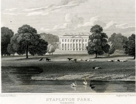
One of the horses, Sir John, is shown with the park in the background (Figure 6). Together with the drawing by Neale in 1829 (Figure 7), it shows the mansion in an area of open parkland, with a few clumps of mature trees. By 1833, Edward Petre had decided to sell and the manor of Stapleton, mansion, park and 1000 acres of land were put up for auction at Garraway’s Coffee House, London on the 30th May (Tew 1892, 65).
Edward Petre mortgaged his property in Yorkshire, including Stapleton, for £4,000 in 1834 (LULSC YAS MD76 139, YAS MD76 140) as presumably he had failed to sell it the previous year. These mortgages were paid off when Petre sold Stapleton to John Watson Barton in 1838. The tithe map and award of 1839 showed that Barton owned c.1600a, of which 857a was park, pleasure grounds and plantations in his occupation (NA IR29/43/125).
1840 -1919
The tithe map only shows part of the estate, so it is the 1st edition 6” OS map, surveyed between 1848 and 1849 that gives the first complete picture of the designed landscape (Figures 8 & 9). Most notable is the new road created to the east from the Darrington-Womersley road to Kirk Smeaton, following the closure of the old road through Stapleton’s parkland. There are three new lodges: ‘North Lodge’ on the old road from Darrington, ‘West Lodge’ on the main Great North Road and ‘Wentbridge Lodge’ on the southern approach described as a ‘ruin’ but dated after 1813. It may have been part of a route for the horse races, prior to the increase in the plantations to the south as it is next to ‘Horse Race Plantation’.
The 1st edition 6” OS map shows three more buildings in the centre of the northern section of the walled kitchen garden. By 1890, there is a further glasshouse in the centre of the southern section (Figure 10). The area to the south remained as paddocks but now with a central avenue of trees leading from the southern glasshouse. On the northern edge of the pleasure grounds, just south of the main stables was a stone and brick summerhouse (ERA DDSE 9/4).
From the 1919 catalogue (ERA DDSE 9/4), there is the following description of the estate’s grounds:
Stapleton Park Estate…Substantial Stone-built Residence standing in an undulating and finely timbered park of 500 acres…and whole [estate] comprising about 2,500 acres.
The Estate is approached from the Great North Road guarded by the stone-built West Lodge of classic design…by a lengthy Carriage Drive meeting the North Drive, guarded by the North Entrance Lodge winding through the undulating and finely timbered park of 450 acres with a fine Fish Pond or Lake of nearly six acres.
The Pleasure Grounds, surrounding the Mansion on three sides, commanding beautiful Park Views, comprise in all some 12 acres, and are laid out in Rose and other Flower Beds with some fine Cedar, Yew, Beech and other trees. In the West gardens is a large stone and brick built Summer House or Loggia now used as an Implement House.
The Walled Kitchen Gardens, all with Southern slope, are enclosed by high stone and brick walls, with five Peach Houses, four Vineries, Plant House with own Heating Stove. Outside are Fig and Melon Houses, and two ranges of Pits.
Gardener’s Cottage of stone construction…with Fruit Room, Boiler House containing two Vertical Boilers (for use singly or together), Mushroom House, Mess Room and other Sheds. In Park, close to the gardens, is a Large Open Surface Water Tank holding thousands of gallons, which serves Kitchen Gardens by Pumping.
The Extensive Woodlands of some 321 Acres bound the estate on three sides, and include Fish Pond, Wood, Sod Wall Plantation, part of Brockodale Plantation, Kirkdike, Long and West Park Plantations, affording excellent cover for Game, and with the Park Lands.
Later history
The sale on the 30 October 1919 started a long period of decline for the estate after the First World War. It had a succession of owners as property and land were sold for a quick profit. Stapleton Park was divided into lots but the main house and grounds failed to sell initially and were put up for auction again (Leeds Mercury, 8 November 1919). In 1921, a dismantling sale of the mansion was to be held on 9-11 February (Yorkshire Post and Leeds Intelligencer, 24 January) and on the 30 March of that year, it was reported that the floors and joists had been sold (Yorkshire Post and Leeds Intelligencer).
In 1937 the estate was finally bought by the West Riding Mental Hospital Board with the intention of housing patients there. However the outbreak of World War II prevented this and the building was deemed unfit for use. The house was demolished in the late 1930s and the estate was sold on the 21 January 1958 by order of the Ministry of Health. The parkland today has been largely converted to arable cultivation with small areas of pasture retained.
Location
Stapleton Park lies 2km (1.2 miles) south east of Darrington and 5.5km (3.5 miles) south east of Pontefract.
Area
The mansion, gardens and historic parkland (Figure 11) covered an area of 200 hectares (500 acres).
Boundaries
The northern boundary of the parkland runs along the road from Darrington to Womersley until the northern entrance to the Hall at SE 506196. It then continues 160m south of the road towards the road to Little Smeaton to SE 511194. The eastern boundary follows the ‘New Road’ (to Little Smeaton) from SE 514194 to the southern extent of the Old Quarry at SE 515182. The southern boundary follows the River Went from SE 507171 to Wentbridge. The western boundary follows the Great North Road from Jackson’s Hill Plantation to West Lodge and then the western edge of ‘Long Plantation’ until North Lodge.
Landform
The site of the mansion, immediate gardens and lake lies between 15m and 20m AOD, with the ground to the north, west and south rising to between 30m and 50m AOD. The highest point is Jackson’s Hill at 71m AOD to the south west and overlooking the former racecourse to the north. Stapleton Park’s underlying geology is Dolostone (Cadeby Formation) with Calcareous Mudstone (Edlington Formation) forming the eastern edge of the parkland, overlain with freely draining lime-rich loamy soil primarily under arable cultivation.
Setting
The main buildings of the estate lay in a valley and were surrounded on three sides by rising parkland and plantations, thus creating uninterrupted views from the house. On the fourth side was the lake and beyond Castle Farm, thought to have been erected as an eyecatcher (see Section 3.3.1). The site lies in the Selby District Local Landscape Character Area: West Selby Ridge.
Entrances and approaches
North Lodge
This dates after 1818 and the diversion of the Darrington to Kirk Smeaton road, as it does not appear on the 1813 sale plan but is shown on the tithe map of 1839. From here the carriageway went south and then east to the front of the Hall, the latter part of which was the original approach as shown on the 1813 map before the public road was diverted. No visible evidence remains and the entrance is disused.
West Lodge
This also dates from between 1818 and 1839 and gives access to the estate directly from the Great North Road (A1). The carriageway from here then heads due east and joins the one above to the Hall. Remnants of the building (now a road café) remain, including the lower storey façade with neoclassical columns and doorway.
Wentbridge Lodge
This marks the start of the estate from Jackson’s Lane. It dates from between 1848 and 1892 and a building remains on the site. On the 1st edition OS map, there is another building called Wentbridge Lodge but this is further north and described as a ruin in 1848. This earlier building may have served as an entrance to the racecourse from the Great North Road, which is thought to lie in the nearby area called ‘Horse Race Closes’.
Northern Entrance
This is on the Darrington to Womersley road and was likely to be the ‘service entrance’ as it led due south to the stable block. It first appears on the 1839 tithe map.
Castle Hill Entrance
While not a formal entrance, it gave access to the eastern parkland via the ‘New Road’ to Kirk Smeaton.
Principal buildings
Stapleton Hall
There are no visible remains above ground, although cellars to adjoining service building to the north still survive.
Former Stable Block [Grade II*, NHLE No 1316346]
Built c.1762, with later alterations for Edward Lascelles.
Castle Farm [Grade II, NHLE No 1148372]
Mid to late 18th century farmhouse, built as an eyecatcher from Stapleton Hall.
Icehouse
East of the stable block at SE 507193, it first is first recorded on the 1st edition OS map surveyed 1848/9. It may well date from earlier as a small area of woodland surrounding it is shown on the tithe map of 1839. There are no visible remains, although a grassed-over mound in the locality may contain the remaining structure.
Gardens and pleasure grounds
To the north and west of the Hall were 12 acres of pleasure grounds. The 1919 sale catalogue mentions rose and other flower beds with specimen trees such as cedar, yew and beech. In the northwest gardens was a large stone and brick summerhouse. These have now all gone.
Kitchen garden
The walled kitchen garden of just under 5 acres (Figure 10) lay to the north west of the house and by 1919, was
‘enclosed by high stone and brick walls, with five Peach Houses, four Vineries, Plant House with own Heating Stove. Outside are Fig and Melon Houses, and two ranges of Pits…[there was also a] Gardener’s Cottage of stone construction…with Fruit Room, Boiler House containing two Vertical Boilers (for use singly or together), Mushroom House, Mess Room and other Sheds.’ (ERA DDSE 9/4)
It first appears on the 1813 sale plan but dates from before that. In 1786, John Carr refers to men who had built 'Lord Stourton's Garden walls' in a letter of the 13 June of that year (Hall 1989, 97), although it probably refers to his property at Holme Hall. It is more likely to have been built in the 1760s when the modifications to the Hall and the construction of the stables were being undertaken. There are still small bricks that could pre-date the introduction of the 1784 Brick Tax in the surviving walls in the northern section (site visit, 30 August 2017) and the curved corners of the northern brick section (c. 2 acres) are similar to those at Carlton Hall (Wickham and Ratcliffe 2016, 12). There are four small buildings behind the northern wall on the eastern side and these are the early furnaces for the hot walls dating from the initial construction. A similar design was used for the central hot wall at Carlton by Woods (Susan Campbell, personal communication). These pieces of evidence point to the fact that it may be the work of Richard Woods.
The southern section has stone walls and may post date the brick walls to the north but appear on the 1813 sale plan. By 1839, the tithe map shows them as part of the area labelled ‘2 Gardens’, an area of just over 3.5 acres. It would appear to be an orchard by the 1890s with the central feature of the glass ‘Plant House’ that may have housed exotic plants.
Park and plantations
Stapleton Park
Initially created in the 1760s to complement the house built by Edward Lascelles, it was further enlarged by Edward Petre in the 1820s to cover 150 hectares (382 acres) by 1839. By 1849, the farmland to the north west had been incorporated and the park was at its greatest extent at 180 hectares (450 acres).
West Park/Plantation
Dating from the 1820s, this extension of the park together with perimeter planting was created alongside the new West Lodge.
Long Plantation
Dates between 1813 and 1839.
Fish Pond Wood
The northern section was in situ by 1813 and formed part of the landscaping around the lake. Between 1839 and 1849, a southern section was added to link up with the eastern perimeter planting.
Castle Hill Wood
Also known as ‘Quarry Hill Wood’, it dates from before 1813.
Sod Wall Plantation
Dates from before 1813.
Brockadale Plantation
Dates between 1813 and 1839. Part of this survives and is now part of a Yorkshire Wildlife Trust nature reserve - http://www.ywt.org.uk/reserves/brockadale-nature-reserve
Kirkdike Plantation
Dates from before 1813.
Charcoal Plantation
Dates from before 1813.
Horse Race Plantation
Dates probably after 1849 as not shown on tithe map as in Darrington township.
Water
The lake known as the ‘Fish Pond’ first appears in its present form on the 1813 sale plan but may be a remodelling of the water shown on the 1771 Jeffrey’s map. From the site visit (30 August 2017), the bottom appears to be puddled clay and there are no obvious stone or other revetments, suggesting an earlier construction date.
Books and articles
Carleton, J. W. ed. 1867. The Sporting Review. London: Rogerson and Tuxford.
Clay, J. W. ed. 1895. Yorkshire Royalist Composition Papers Vol 2 (YAS Record Series, Vol 18). London: Yorkshire Archaeological Society.
Cowell, F. 1986. ‘Richard Woods (?1716-93): A Preliminary Account: Part I. 'Woods Surveyer at Chertsey in Surry' and at London Stile’, Garden History 14, 2: 85-119.
Cowell, F. n.d. Research on Stapleton for PhD thesis, unpublished.
Hall, E. 1989. ‘Hot Walls: An investigation into their construction in some northern kitchen gardens’, Garden History 17, 1: 96-107.
House of Lords 1817. Journals of the House of Lords, Volume 60. London: HM Stationery Office.
Lynch, K. 2016. ‘Capability Brown in Yorkshire’, New Arcadian Journal 75/76, 37-107.
Mowbray, B. C. J. 1899. The History of the Noble House of Stourton. London: Elliot Stock.
PRO 1908. Calendar of the Charter Rolls, Vol. 1. London: HMSO.
Tew, T.W. 1892. Miscellaneous Papers 1861-1891. Pontefract: Richard Holmes.
Turnbull, D. 1990. ‘Thomas White (1739-1811): Eighteenth Century Landscape Designer and Arboriculturist’. Unpublished PhD thesis, University of Hull.
Wickham, L. and Ratcliffe, M. 2016. Carlton Towers park and garden. Selby District Historic Designed Landscape Project. Report for the Yorkshire Gardens Trust.
Primary sources
Cumbria Archive Centre (CAC)
WD TE/UB 104 Probate of will of Thomas Braithwaite of Ambleside, esq. made 9 November 1674 and proved (Prerogative court of York) 3 May 1675
East Riding Archives (ERA)
DDCC131/132 Articles of agreement for purchase of Stapleton. Lord Stourton to pay £18,000 to Edward and Daniel Lascelles, signed 1 July 1782. Lord Petre and Thomas Clifford of Tixall sign the agreement as trustees to Lord Stourton’s marriage settlement
DDSE 9/4 Sale catalogue for the Stapleton estate, 1919
Hepworth Wakefield, The Gott Collection (HWTGC)
A1.91 10/50 Plan of the Lordship of Stapleton and lands laying within the townships of Cridling Stubbs and Little Smeaton, Yorkshire, engraved under the direction of Messr. Driver by G. Mills, 51 Nelson Sq., Blackfriars, 1813
Lancashire Archives (LA)
DP 397/17/5 Richard Standish of Duxbury, esq., son and heir of Richard and Elizabeth Standish, decd. to James Greenwood of Stapleton, co. York, gent, 1/3 of manor of Stapleton, 1675
DP 502/1/12/1 Order in Court of Chancery concerning a decree of 13 Feb 1649 relating to the manors of Barwicke, Scoles and Stapleton, Yorks between Lawrence and Frances Rusford, Thomas and Margaret Braithwaite and Richard and Elizabeth Standish, plaintiffs and Thomas Lord Savile, Gregory Armitage gent and Anne Leigh, defendants, 15 Mar 1659
Leeds University Library Special Collections (LULSC)
Yorkshire Archaeological Society Archives
YAS MD76 139 4 December 1834, Hon. Edward Robert Petre to Mr Caleb Coles. Mortgage in fee of the Reversion of certain Freehold Estates in the County of the City of York...and assignment of a policy of Assurance . . .and an Annuity and other personal estate and rents, to secure the sum of £2,000 and interest. 15 October 1838, Mr Caleb Coles to Hon Edward Robert Petre. Reconveyance, reassignment and release of above. Capital house etc. STAPLETON
YAS MD76 140 6 December 1834. Hon. Edward Robert Petre to Henry Lainson Esq. Mortgage in fee of the Reversion of certain Freehold estate in County of the City of York and an assignment of a policy of Assurance…and an Annuity and other personal estate and rents for securing sum of £2,000 and interest. 18 September 1838, Henry Lainson Esq to Hon Edward Robert Petre. Reconveyance, reassignment and release of above. Reference to marriage settlement, Edward Robert Petre and Maria Stafford Jerningham. Capital Messuage of Stapleton . . . much re properties, monies and other items (including race horses)
National Archives (NA)
IR 29/43/125 Tithe map and apportionment for Darrington (Stapleton township), 1839
RHS Archives (RHSA)
Brown Account Book f.160
The Right Honourable the Lord Stourton for Stourton House in Yorkshire 1782 Mr Spyers Expences to & from Stourton House in Yorkshire from Oct 31 to Dec the 4 1782 8.15.0. There in October 1782 myself. Recd by exors 69.10.0
Sheffield Archives (SA)
MD3781 Articles of Agreement between Lascelles and Stourton, Manor and capital messuage of Stapleton and Cridling Stubbs, 12 March 1782
West Yorkshire Archives (WYAS)
WYL250/3/216 Samuel Popplewell’s accounts for Edward Lascelles at Stapleton; July 17th 1762, paid George Boocock for valuing the furniture at Stapleton
WYL250/SC/3/3/70 Letter from Edwin Lascelles to Samuel Popplewell, 15 May 1762
WYL250/SC/3/3/164 Letter from Edward Lascelles to Samuel Popplewell arranging a visit and awaiting Mr Carr to begin some building work, 10 October 1762
WYL250/SC/3/3/204 Letter from Sarah Carr to Samuel Popplewell describing Mr Carr's journey to Stapleton, 5 December 1762
WYL250/SC/4/1/6 Letter from Edward Lascelles to Samuel Popplewell, 6 January 1763
WYL250/SC/4/1/24 Letter from Edward Lascelles to Samuel Popplewell, 1st February 1764
WYL250/SC/4/3/18 Letter from Edward Lascelles to Samuel Popplewell, 7 March 1781
WYL250/SC/4/3/29 Letter from Edward Lascelles to Samuel Popplewell, 27 April 1781
Maps
Warburton’s map of Yorkshire, c.1720
Bowen’s map of Yorkshire, c.1750
Dickinson’s map of the West Riding of Yorkshire, 1750
Jeffrey’s map of Yorkshire, c.1771
Ordnance Survey 6” 1st edition, surveyed 1848 to 1849, published 1853
Ordnance Survey 25” 1st edition (CCL.6), surveyed 1890, published 1892
Ordnance Survey Wakefield (Outline) Sheet 78, revised 1894, published 1896
Figure 1 – House at Stapleton near the River Went on John Warburton’s map of Yorkshire of c. 1720
Figure 2 – House at Stapleton with possible parkland and water on Joseph Dickinson’s map of the West Riding of Yorkshire, 1750. Reproduced by permission of Sheffield Local Studies Library: Picture Sheffield www.picturesheffield.com
Figure 3 – Part of 1813 Sale Plan (HWTGC A1.91 10/50) showing ‘New Park’ and ‘Old Park’. Image courtesy of The Gott Collection, Hepworth Wakefield.
Figure 4 – Stapleton Park on Jeffrey’s map of Yorkshire, 1771. Source: North Yorkshire County Record Office
Figure 5 – Sale plan for Stapleton estate (HWTGC A1.91 10/50), 1813. Image courtesy of The Gott Collection, Hepworth Wakefield.
Figure 6 - The Hon. Edward Petre’s Brown Colt Sir John at Stapleton Park, Yorkshire by John Frederick Herring, 1822, http://thesportingartauction.com/lot/hon-edward-petre%E2%80%99s-brown-colt-sir-john-stapleton-park-yorkshire, consulted 11 April 2017
Figure 7 – Stapleton Park engraving by JP Neale, 1829. Image ©Trustees of the British Museum
Figure 8 - Northern section of Stapleton Park showing North and West Lodges, mansion, gardens, parkland and Fish Pond. Ordnance Survey 6” 1st edition, surveyed 1848 to 1849, published 1853. Reproduced by permission of the National Library of Scotland
Figure 9 - Southern section of Stapleton Park showing approach via Wentbridge Lodge and southern plantations. Ordnance Survey 6” 1st edition, surveyed 1848 to 1849, published 1853. Reproduced by permission of the National Library of Scotland
Figure 10 - Walled kitchen garden showing layout and position of greenhouses (marked in blue). Ordnance Survey 25” 1st edition (CCL.6), surveyed 1890, published 1892. Reproduced by permission of the National Library of Scotland.
Figure 11 - Stapleton Park estate from Ordnance Survey Wakefield (Outline) Sheet 78, revised 1894, published 1896. Reproduced by permission of the National Library of Scotland.


 showing ‘New Park’ and ‘Old Park’.")

, 1813.")

. Ordnance Survey 25” 1st edition (CCL.6), surveyed 1890, published 1892.")


 Sheet 78, revised 1894, published 1896.")