Thicket Priory park and garden was formerly the site of a Benedictine nunnery founded in about 1190 located alongside the River Derwent. After the Dissolution, a house was built adjacent to the old nunnery complex. An axial walk and tree avenues, typical of late 17th and early 18th century gardens, were laid out in a small parkland.
With the building of a new hall, designed by Edward Blore in the 1840s for Rev. Joseph Dunnington-Jefferson, the designed landscape took on a more naturalistic style. It was extended by the 1890s to about 220 acres (89 ha) and incorporated parkland studded with tree clumps, a large sinuous lake surrounded by pleasure gardens and ‘coniferium’ with walks. Earlier enclosed gardens were remodelled into a walled kitchen garden.
Although much of the parkland has been returned to farmland, the main features of the late 19th century landscape can still be discerned with remnants of earlier periods too. Archaeological survey and excavation have revealed monastic features and phases of the post-medieval garden development within the walled garden. Ecclesiastical links remain as Carmelite nuns occupy a modern monastery within the old walled garden. The long occupation of the site provides historic significance.
Estate owners
The riverside site of Thicket Priory park and garden runs across the boundary between the parishes of Thorganby and Wheldrake, with the site of buildings and the largest proportion of the land being within Thorganby. (Thorganby comprises the older parishes of West Cottingwith (northern half) and Thorganby (southern half)).
Roger son of Roger, an early demesne tenant of West Cottingwith, founded Thicket nunnery about 1190. Records show that he and others donated land in West Cottingwith and Wheldrake to the St Mary’s Benedictine nunnery, confirmed by a charter from King John in 1204 (EYC1). In West Cottingwith the gift comprised: Roger son of Roger 4 bovates; Thomas son of Roger ½ carucate; Picot 1 bovate (total about 55 ha (135 acres)). In Wheldrake the gift comprised: Geoffrey de Fiteling 2 bovates; Hugh de Bolton 2 bovates; Emma de Dilolton 1 bovate (total about 30 ha (75 acres)) (ibid). Dugdale, writing in 1693 indicates ‘Thickhed’ nunnery as being in the parish of Wheldrake, perhaps because the nunnery originally had land in different parts of Wheldrake, but quitclaimed the castlery of Wheldrake to Fountains Abbey in 1219 (EYC2). It is possible that most of the riverside land owned by the nunnery, with its main complex of buildings in West Cottingwith, extended across the parish boundary between West Cottingwith and Wheldrake and occupied a similar area to the later 19th century Thicket Priory estate, as some of the land gifted to the nunnery in Wheldrake descended with the site of the nunnery to future owners of Thicket Priory (VCH1).
The Benedictine nuns were in occupation until the dissolution of the monasteries. John Aske of York was granted the former monastic estate by Henry VIII in 1542, with another John Aske selling it to John Robinson in 1596 (VCH2). The estate remained with the generations of Robinsons. In 1752 Nicholas Robinson left his estate to his daughter, Sarah, who married Henry Waite, becoming Henry Waite Robinson on Nicholas Robinson’s death in 1754. In 1801 the Revd. Nicholas Waite Robinson sold 23 acres (9.3 ha) to Robert Jefferson and in 1803 the remainder of the lands, comprising 220 acres (89 ha), including Thicket Priory estate, to Joseph Dunnington (VCH2), grandson of Thomas Dunnington. The Dunnington-Jefferson family tree (Figure 1) shows the succession to land and estates across Thorganby and West Cottingworth was not straightforward. Rev. Joseph Dunnington-Jefferson inherited Thicket Priory from his father, Joseph.
By 1840, Rev. Joseph Dunnington-Jefferson owned most of the land in Thorganby and West Cottingworth, along with the Thicket Priory estate and Thorganby Hall. In 1841 Rev. Joseph Dunnington-Jefferson was living at Thicket Priory. Between 1844 and 1847 Joseph had a new house, designed by the architect Edward Blore, built on the Thicket Priory estate.
On Joseph’s death in 1880, Thicket Priory passed to his eldest son Joseph John, who died without issue in 1928. The estate was then inherited by John Alexander, Joseph John’s nephew, the son of Mervyn Dunnington Jefferson (Rev. Joseph’s second son). Joseph John and John Alexander appeared to have very sporadic residency at Thicket Priory (1881-1911 census records; 1939 register). In 1955 Sir John Alexander Dunnington- Jefferson (1884-1979) sold Thicket Priory house, along with 23 acres (9.3 ha) of land to Carmelite nuns, who were moving from Exmouth. The Prioress at the time was Mother Mary of Saint-John Vavasour, whose family home was Hazelwood Castle near Tadcaster. Sir John had moved to Thorganby Hall prior to 1939 (resident at Thorganby Hall on 1939 register; Thicket Priory vacant except for gardener’s cottage). He sold the remainder of the Dunnington-Jefferson landholdings in Thorganby and West Cottingworth in 1964 to J.B. Eastwood, who used them as productive farmland. In 2008 the main building of Thicket Priory with 16.5 acres (6.7 ha) of land was sold and is now in private ownership. The funds were used by the Carmelite order to build a new monastery, which the nuns now occupy, to the southeast of the house in the grounds of the walled garden (6.5 acres (2.6 ha) in total).
Key owners responsible for major development of the designed landscape:
John Robinson and descendants (1596 – c.1812)
Rev. Joseph Dunnington-Jefferson (c. 1840 – 1880)
Early history of the site
Benedictine nuns occupied the riverside site from c.1190 until c.1539, the time of the dissolution of the monasteries. There are records of archiepiscopal visitations to the nunnery over the centuries, often it appears to chastise wayward nuns or deal with complaints (VCH3). The riverside landscape supported cattle meadows and fishing: in 1484 fields and pasturage were flooded with much loss of cattle (VCH3); ‘Thicket priory had a weir at West Cottingwith in 1332, presumably for fishing; along with others it was said to obstruct boats and cause flooding’ (VCH2).
At the Dissolution the Priory included ‘a church, chapter-house, cloisters, hall, two parlours, bakehouse, buttery, kitchen, and various chambers’ (VCH2). A transcription of the transfer to John Aske in 1542 records a ‘chief house of the late Priorie of Thickede with all the singular houses, barns, stables, dove-houses, buildings, structures, pooles, orchards, garden, land, soil and grounds within the site.’ (UDDJ/14/396). This description suggests the Priory was a typical Benedictine, self-contained complex, with river frontage, and that there was some survival of buildings, rather than wholesale destruction, after the Dissolution. Indeed, a surviving Dissolution survey gives some details of the layout, but not the exact location, of the priory: ‘the church was placed on the south side of the cloister, the east side of the cloister contained the chapter house and an upper floor dormitory, and the north side was occupied by a brew house and bolting house. The west side of the cloister was formed by the new house, the new parlour and the buttery, all of which were of timber-framed construction and “coueryd wt tyles”’ Richardson and Dennison (2007, 2). By 1542 any woodland in the area had been cleared, as the grant of the Thicket priory estate to John Aske included £2 for the repair of buildings because of the scarcity of trees in the neighbourhood (VCH2).
Chronological history of the designed landscape
c.1596 - 1817
There appear very few records of the buildings and landscape between the Dissolution and enclosure in 1817. Evidence for the layout of buildings and landscape during this time comes mostly from architectural investigations undertaken in 2007 (Richardson & Dennison) and the enclosure map of 1817 (HA U DDJ/14/395). Over the time that the Robinsons owned Thicket Priory (1596 – 1803), at least one new house was built. The “capital house” of Thicket was mentioned in 1656, and in 1672 Richard Robinson occupied a house with ten hearths (VCH2). In c.1720 the house, seat of Humphrey Richardson, depicted on a contemporary sketch by Samuel Buck, was described as a ‘plain square building with mullioned and transomed windows’ (Richardson & Dennison, 2). Thicket Priory is shown on John Warburton’s 1720 map, with some woodland and a church or chapel (Figure 2). Thicket Hall is shown on Thomas Jefferys’ 1771 map, with no apparent parkland and in the ownership of Henry Waite Esq. (Figure 3).
The combination of the 1817 enclosure map (HA U DDJ/14/395) and Richardson and Dennison’s 2007 architectural assessment gives some clues as to the development of the landscape prior to ownership by Rev. Joseph Dunnington-Jefferson in 1840. In 1817 the estate was in the ownership of Joseph Dunnington and had a total area to the east side of the road of about 143 acres (57.9 ha) – this excludes the extreme northern end in Wheldrake parish. The enclosure map shows an E-W walk of over 11 acres (4.5 ha); Hall gardens of just over 2 acres (0.8 ha) and an orchard of 4 acres (1.6 ha) (Figure 4). Thicket Hall, built by the Robinsons, was sited on the south side of a quadrangular range of buildings, surrounding a small garden as seen on the 1817 enclosure map (Figure 4). The layout suggests the quadrangle was possibly the remains of the priory buildings enclosing a cloister or court (ibid, 2). The site lay close to the River Derwent, but situated on higher ground above the floodplain at 8m AOD.
To the west of the Hall was a rectangular garden with a curved front, containing two small rectangular ponds. This faced out onto a broad axial walk with a central path, giving views from the Hall to the landscape beyond, where there is place-name evidence on the 1854 OS map of a former deer park. This arrangement of axial walk with a half-moon, or parterre, and association with a deer park is seen at Healaugh Park (Boutwood 2016, 12-13) and landscapes in the East Riding of Yorkshire at South Dalton and Londesborough (Neave and Turnbull 1992, 51 & 68). The latter has a geometric pattern of radiating tree avenues, elements also seen at Thicket Priory (Figure 5 & 6), which is typically found in designed landscapes between the late 17th and early 18th centuries.
On the east and south sides of the Hall were enclosed areas, possibly gardens, both with small apsidal ends on one of their sides. A similar shaped garden is also seen at Londesborough on Knyff & Kip’s 1708-9 engraving. The south wall of the southern garden at Thicket Hall, had a double structure flanking the bow end, interpreted as a pond or ha-ha (Richardson and Dennison 2007,3) (Figure 7). Although the Hall was later demolished and parts of the walled enclosures incorporated into later garden structures and kitchen walled garden, the architectural form of some of the surviving walls showed moulded string courses, possibly of late 16th or early 17th century date, or even earlier (ibid, 15).
To the east of the quadrangle and north-east of the Hall lay an orchard extending down to the river, which was later reduced in size within a smaller square enclosure. This area faced onto a wharf on the west riverbank, depicted on the 1854 map. In this earlier period access by river would have been an important route to the Hall.
Under the Thicket Priory landholding of Joseph Dunnington there are named closes on the 1817 enclosure map - e.g. Coney Close 12 acres (4.8 ha), Mill 12 acres (4.8 ha), Sey 17 acres (6.9 ha), Acorn 9 acres (3.6 ha). Similar references appear for named land associated with Thicket Priory acquired by John Aske in 1542 - e.g. ‘one close of land and pasture called Miln Platt 10 acres (4 ha), Acorn Close 9 acres (3.6ha), unnamed close 14 acres (5.7 ha) being between Milne Close and Acorn Close’ (UDDJ/14/396). Together these references suggest little change in the size of the Thicket Priory estate, or in the parcels of land, between the Dissolution and enclosure. The field names give some clues as the potential use of the land, or its former use, but it is uncertain if they were part of the parkland setting at this time.
1817 - c.1850
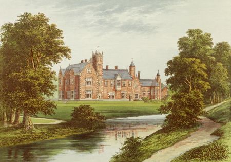
It is likely that the layout of land shown in 1817 remained much as it was until Rev. Joseph Dunnington-Jefferson built a new house between 1844 and 1847 on ground to the northwest of existing buildings. As he was shown as living at Thicket Priory in the census of 1841 with his wife, seven month-old daughter and a retinue of seven servants, it is probable that Rev. Joseph occupied the old Robinson house during the construction of the Victorian house which was designed by Edward Blore. Blore’s previous commissions had included Government House, Sydney and additions to Lambeth Palace and Buckingham Palace.
The first edition OS map of 1854, surveyed 1850/1, shows the designed landscape following the initial revamping of the estate by Rev. Joseph Dunnington-Jefferson (Figures 4 & 8). The new house, with a clock tower by Vulliamy, was built to the northwest of Thicket Hall and north of the axial walk. At the same time Blore designed coach house, stables and brewery attached to the north of the house. The construction of the house and associated buildings altered the symmetry of buildings in relation to the existing walk and avenue to the old house, so that after 350 metres (383 yards) a curved driveway north to the front of the house replaced the original trackway. An entrance lodge, also designed by Edward Blore, was constructed immediately to the north of the E-W avenue.
Earlier garden features were modified, as an icehouse had been inserted into an earlier mound, one of two former garden features at the end of the avenue and walk, possibly designed for statues (Richardson and Dennison 2007, 16-17). Instead a new formal garden parterre was created to the immediate south of the house. The geometric elements were softened by the addition of a more natural style, with scattered tree clumps in the parkland and creation of large sinuous ponds, also remodelling the two rectangular ponds, shown in 1817, into a more irregular shape. Walks surrounding the ponds provided views of the house and formed a pleasing visible feature from the house and terrace. The walks continued into more secluded areas of pleasure grounds lying to the north and south of the ponds.
The old Robinsons’ house appears to be gradually abandoned, although the complex of buildings remains on the 1854 OS map. However, a garden cottage, designed by Blore and built about the same time as the other Blore-designed buildings, appears on later maps to occupy the northwestern corner of the old complex of buildings. It is perhaps likely that most of the complex of buildings between the garden cottage and the walled garden was demolished around this time. However, one small section of the wall of the Robinsons’ house, attached to the northwestern corner of the walled garden remained in situ until at least 2007.
The two enclosed gardens with apsidal ends seen in the 1817 map were remodelled and incorporated into a walled garden by 1854 (Figure 7) (see section 4.9).
c.1850 - c.1900
By the 1890s, the parkland had been extended, with additional features, to produce the maximum extent of designed landscape for the Thicket Priory estate (Figures 9-11). The complex of old Priory buildings close to the northwest of the walled garden had disappeared. Greenhouses and outbuildings associated with a productive Victorian walled garden had been added. House, gardens and parkland occupied about 218 acres (88.2 ha) in total (acreage from 1893 map). There appeared to be minimal change in the landscape between 1893 and 1908.
A driveway extended southeast from a pair of lodges at the northwest corner through parkland to the front of the house, perhaps deliberately exhibiting an extensive estate for travellers from York. Further copses of trees were added in the extended northern parkland, with some lines of trees following the old field boundaries. At the southeast end of the estate, an additional area of river frontage had been incorporated into the parkland. An area of tree plantation (c. 2 ha, 5 acres,) had been added to south of the ponds, identified in the 1908 OS map as a ‘coniferium’. The ponds had effectively been joined, forming a lake with an island connected by footbridges to the west and east banks. On the east bank a boathouse had been added (Figure 11).
The area close to the house comprised extensive pleasure gardens to the northeast and east, with walks around the lake, over footbridges, and through woodland (Figure 11). The walled garden had undergone change, with the 2007 architectural assessment providing detail of change and survival (Richardson & Dennison, 2007) (Figure 7) – see section 4.9.
c.1900 - 1955
Snapshots of occupation of Thicket Priory estate from 1881-1911 censuses show that Joseph John Jefferson was not in residence on any of the census dates 1881-1911. The designed landscape, described as ‘The Park’ on 1910 OS maps (Figure 9), was not developed significantly during his ownership (1880-1928). John Alexander Dunnington-Jefferson, who inherited Thicket Priory estate in 1928, was in residence at Thorganby Hall prior to 1939, again suggesting limited further development of the designed landscape. On the 1939 register, Thicket Priory house was shown as vacant, but a gardener was resident in the gardener’s cottage. The OS map of 1952 shows an estate with very little change since 1908 (Figure 12). The pair of lodges at the northwestern corner are no longer depicted and there may have been changes to cultivation within the walled garden, but essentially the gardens and parkland remained the same as the early 1900s.
1955 onwards
In 1955 Thicket Priory house along with 23 acres (9.3. ha), comprising the main avenue, pleasure gardens, lake and walled garden, became a Carmelite Monastery. Some buildings were added around the house but there seemed little change to the gardens and lake. The walled garden continued to be used as a productive garden. The remaining estate, just under 200 acres (80.9 ha), was sold in 1964 with most of the parkland returning to farmland. However, most of the woodland belt, tree clumps and the plantation related to the ‘coniferium’ remain. In 2007 archaeological evaluations were undertaken within the former walled garden prior to building a new Carmelite monastery in 2008. A detailed archaeological assessment recorded surviving structures and earthworks (Richardson & Dennison 2007). Other excavations also recorded sub-surface deposits associated with the medieval priory buildings and later garden features (NYCC HER: MNY 25297-9; SNY 11835). The house, immediate pleasure gardens and lake were sold into private ownership in 2008.
Location
Thicket Priory is on the west bank of the River Derwent, 2km (1.2 mile) north of the centre of Thorganby and 2km (1.2 mile) south-east of Wheldrake.
Area
The largest area of the historic parkland, pleasure gardens and walled garden was c. 88 ha (218 acres).
Boundaries
The historic Thicket Priory estate is bounded to the east by the River Derwent, and to the west by the Wheldrake-Thorganby road. Most of the northern boundary is formed by Ings lane, running from the Wheldrake road to the River Derwent. The southern boundary follows field boundaries south of Common Drain from the Wheldrake road (SE 469325, 442956) to the River Derwent (SE 469929, 442951).
Landform
Thicket Priory lies in the flat valley of the River Derwent, just to the south of the Escrick moraine and the land is mostly composed of outwash sand and clay. The floodplain on the eastern edge alongside the river has alluvial soils. All the landscape is less than 10m AOD, although the main house is slightly elevated at 8m (25ft) AOD. The underlying geology is sandstone (Sherwood Sandstone Group) overlain with glacial tills and drift (Lake Humber deposits).
Setting
The estate lies in the Selby District Local Landscape Character Area of Skipwith Lowlands typified by flat wooded farmland. The River Derwent, originally important for transport, provided an extensive boundary.
Entrances and approaches
The historic and existing entrance to Thicket Priory is on the Wheldrake-Thorganby Road (SE 469265, 443471).
To the immediate north of the entrance is Gate Lodge (Figure 4), which was designed by Edward Blore, built 1844-47. Grade II listed (NHLE no. 1148430, ‘Built reusing early C18 brick to lower part and with C20 additions and alterations of no special interest. Pinkish-orange brick with Welsh slate roof. Cruciform plan. 2 storeys, each side a single bay.’)
The central path of the wide tree-lined avenue, which originally aligned on the former house, was modified to form a drive. It runs straight west-east for 350 metres (383 yards) then curves north to the front of Thicket Priory house, the later mid 18th century building. Since 2009, at the point where the drive curves north, an additional driveway, curving south then east, runs to the south end of the modern Carmelite Monastery complex in the walled garden.
At the northwest corner of the 1890s estate there was another entrance, flanked by two lodges, from the Wheldrake Road (adjacent to Ings Lane), with a driveway running southeast to front of Thicket Priory house (Figure 10). This entrance is no longer in use, the lodges were demolished by 1950 and the driveway levelled, but its route can be still traced as a cropmark in former parkland that is now arable fields.
In the 1890s, about 180 metres (197 yards) north of the main entrance on the Wheldrake-Thorganby road, there was an entrance and trackway, along an old field boundary, which ran to join the southeast driveway running from the northwest corner. There was a spur on the southeast driveway, just south of this junction, curving east around the northern end of the Thicket Priory buildings. The trackway from the Wheldrake road around to the northern end of the current, diminished estate still exists as a farm track.
The River Derwent bounding the east of the estate had a wharf linked by a path to just north of the walled garden depicted on 1854 OS map (Figure 4). It would have provided another approach to the house, also used for bringing in supplies and giving access for leisure activities on the river. By 1892 the 25” OS map shows the landing stage has moved further north with an adjacent boathouse (Figure 10).
Principal buildings
Thicket Priory
Thicket Priory was designed by Edward Blore, built 1844-47. Grade II listed (NHLE No. 1296552 ‘1844-7 with C20 range to former main facade of no special interest. Orange-red brick with ashlar dressings and grey slate roof. Approximately square on plan. Jacobethan. Main facade now partly-obscured by later range. Garden facade: mainly of 2 storeys, with 8 first floor windows, 4-stage tower and 3 stage stair turret and with chapel to northeast corner.’)
Coach house, stables and brewery to Thicket Priory
Coach house, stables and brewery adjoin the north of house. Designed by Edward Blore, built 1844-47. Grade II listed (NHLE no. 1148431 ‘1844-7 with later additions of no special interest. Orange-red brick in English bond with ashlar dressings and grey slate roof. Quadrangular with central coach house with range of stables to each end, the 4th side occupied by brewery and gabled archway’.)
Garden Cottage
A cottage, originally occupied by the gardener, exists to the northwest of the walled garden. Designed by Edward Blore and built 1844-47. Grade II listed (NHLE no. 1316332 ‘Pinkish- orange brick with ashlar dressings and Welsh slate roof. L-shaped on plan with range to rear. Single storey, 2-bay range with 2-storey, single gabled bay range at angle.’
Icehouse
The position of an icehouse is shown on the 1854 OS map by two coniferous trees (Figure 8), later labelled ‘old icehouse’ by 1893, remaining as such on the 1952 OS map. It was inserted into a mound, a former garden feature located at the eastern end of the walk and tree avenue. The mid-C19th century icehouse structure still remains intact (Richardson and Dennison 2007, 16-17)
Gardens and pleasure grounds
Formal gardens and pleasure gardens are evident on the early OS maps and traces still exist, particularly around the lake. These gardens were likely to have had their origins in landscaping from the late 17th/ early 18th century – for example, the geometry of the tree lined walks (Figure 5). Although the land is mostly flat, the 19th century house and ground to the immediate south are very slightly elevated. At the eastern end of the original 18th century (or earlier) avenue and to the west of where two ponds were situated in 1817, the 1890-1908 OS maps ‘depict a lowered Ushaped area, open to the east end and flanked by scarps scrolling into circular features at their eastern ends. Although it has been subject to some later disturbance, the lowered area is still clearly visible as an earthwork, both sides scrolling into mounds at their west ends. The north mound is c.7m across and sub-square in plan with a flattened surface. The south mound is very overgrown.’ The mounds may have been bases for statuary and ‘it is considered most likely that the mounds were raised as part of the c.1700 house’s designed landscape’ (Richardson & Dennison, 16-17). This half-moon, radiating avenue has parallels in other early gardens (see section 3.3.1) (Figure 6).
Immediately to the south of the Blore house a formal garden of about 0.44 acres (0.18 ha) was laid out as shown on the 1854 OS map with a geometric pattern of five beds. By the 1950s this had become an area of grassland containing small (fruit?) trees laid out in a regular pattern. Pleasure grounds, with many walks through trees and around the lake existed to the north, east and south of the 1844 house. To the north of the house was a glade within trees and a rectangular sunken garden. To the south, the network of paths included those based on the earlier raised half-moon and some circular walks. The early enclosed garden with apsidal ends was remodelled into a walled garden, and later became a kitchen garden (see section 4.9) (Figure 7).
In total, including the formal garden and an area of open grassland to the south of the lake, there were about 19 acres (7.68 ha) of pleasure gardens in 1908.
Although there has been loss of the open grassland to the south and some small diminution to the north of the house, the pleasure grounds appear to be similar to the layout that existed in the 19th century, and which was based on earlier landscaping.
Kitchen garden
There was extensive survey of the walled garden in 2007 tracing its history and survival, prior to construction of the modern monastery in its precincts (Richardson & Dennison). In 1817 the area that was to become the Victorian walled kitchen garden of about 1.12 acres (0.45 ha) had two parts. ‘The smaller part was formed by a rectangular enclosure, attached to and centred on the rear of the (1700s Robinson) house, with a small bow projecting from the centre of the east side. To the south of the house, there was a larger enclosure ….. with a bow towards the centre of the south side; the bow is flanked by double lines which might, given the vista, denote a ha-ha or possibly a pond’ (Richardson and Dennison, 3). By 1854, the layout had been modified – the northern part had a large curved eastern wall in place of the straight wall with small bow; the southern part had been enclosed as a roughly square walled garden (Figure 7).
Between 1854 and 1898, the interior east-west wall between the two previous parts of walled garden had been removed. The previous northern part had been divided into two, with the western part labelled as Burial Ground on the 1908 map (Figure 7). It is not known what is meant by the ‘burial’ reference. By 1898 ‘the largest alteration was the construction of a range of greenhouses along the south face of the north garden wall. These would have taken the form of a central conservatory, covering the area of the surviving flagstone floor, flanked by tall lean-to structures, one of which was almost certainly a vinery. The north-south aligned garden walls and the curved bay were used for growing fruit trees (plums and pears respectively) and all retain elements of the later 19th century support system for the trees; only the rebuilt southern section of the east wall does not retain any such evidence. There is no evidence that any of the garden walls were heated, to “bring on” or protect the fruit from frost. The resulting walled garden at Thicket Priory covers an area measuring c.50m east-west by c.85m north-south.’ (Richardson & Dennison, 19) There were long lean-to structures on the north side of the north wall including a boiler room. The form of the sunken greenhouse to the immediate north of the walled garden indicates that it was a forcing pit (Figure 12). The large glasshouses against the north garden wall, shown on the 1898 and 1908 maps were eventually replaced by the much more modest greenhouses which still stood in 2007. The west garden wall still had plum trees planted against it in 2007, with many retaining ‘their 19th century zinc labels which identify the type of fruit and variety: Plum- Early Transparent Gage; Giant Prune; Victoria; Monarch’ (Richardson & Dennison, 7). The wires, which originally supported the trees had mostly gone by 2007, although the guide loops and the 19th century castors, used to tension the wires, survived at either end of the wall. The east wall consisting of a curved bay and a straight section still had mature pear trees planted against most of its length in 2007. As with the plum trees, zinc labels survived, identifying the varieties as: Pitmaston Duchess; Beurre d’Amanlis; D’Heyst; Thompson DG; Williams DG; Marillat; Diel; Conference; Souvenir De Congress DG; LR de Jersey; Roosevelt; Laxton’s Superb; Glou Marceau; Marie Louise DG; Durondeau; Comice; Doyenne de Comice; William Bon Chretien; Catillac; Winter Nelis. By 2007 most of the walled garden was uncultivated and grassed over.
Park and plantations
At their largest extent in 1893, the parkland and plantations occupied about 182 acres (73.6 ha). This was a substantial increase, mostly to the north, on the parkland in 1854 which was about 116 acres (47 ha). There was a significant area of land (11.8 acres, 4.77 ha) close to the river, which is shown on most maps as liable to flood. The southern part was originally shown as parkland in 1854, but by 1892 had extensive floodbanks and was excluded from the parkland (Figure 9).
The parkland contained several avenues of trees in addition to that lining the broad east-west axial walk, aligned on the west façade of the house and later used as a driveway. One avenue ran northeast, from the southwest corner of the estate towards the southern part of the gardens, but finishing before it reached there. This geometric pattern is reminiscent of a patte d’oie (radiating avenues in the shape of a goose foot). Another tree avenue ran from the enclosed gardens and ha-ha with views down to the river. At its southern end it has a broad form with a double row of trees. At its northern end, aligned exactly with the apsidal end of the garden wall, it had an additional line of trees forming a triple tree avenue, which may have been a later enhancement, as occurs at Watton Abbey, East Yorkshire, on a plan of 1859 (Neave, 2013, 7).
A plantation of 5.37 acres (2.17 ha), containing walks, was laid out to the south of the house and gardens between 1854 and the 1890s. Its southern part is bisected by the Common Drain flowing into the River Derwent. On the 1908 OS map this plantation was labelled as a ‘coniferium’. The plantation today maintains the same footprint as on the 1892 OS map.
The 1817 map shows about 4 acres (1.6 ha) of orchard to the north of the walled garden and extending to the river. By 1854 only the western half, away from the river, appears to be orchard, remaining as such probably until 1964.
There were clumps of trees, totalling 7.3 acres (3 ha), dotted about the parkland from 1854, with northern additions by the 1890s. Although most of the parkland reverted to farmland from 1964, nearly all of the tree clumps remain.
There are narrow shelter belts of trees along the northern boundary of the parkland and clumps along the western road boundary, which are perhaps small plantations deliberately placed to screen the home farm (6.87 acres, 2.78 ha). These were in existence by 1854.
Water
Two small sub-rectangular ponds are shown on the 1817 enclosure map at the eastern end of the avenue. By 1854 these had been merged into one irregular U-shaped pond, with the open end at the west. Another much larger sinuous pond was created to the north. By 1893, the ponds had been joined and extended as one continuous lake of 2.12 acres (0.86 ha), with a small island in the southern part accessed by footbridges to the west and east. A further footbridge ran across a narrow part of the northern section. A boathouse existed on the eastern side of the lake by 1892 and a small building, probably a summerhouse, on the south side, would have given views across the lake. The lake and footbridges appear to remain.
The low-lying parkland had a number of water management features and was drained by water channels. The Common Drain shown on the 1854 map runs east, from farmland on the west side of the Wheldrake road and across the southernmost part of the historic parkland into the River Derwent. The former area of parkland by the river, east of the house, also had a drain and sluices controlling the water flow and flood embankments. The river supplied water, which was stored in a large rectangular reservoir with an adjacent octagonal water house, or pumping house as seen on 1854 and later OS maps (Figure 8). Sections of banks on the east side of the garden probably acted as flood defences, along with the river bank.
Books and articles
Boutwood, Y. 2016. Healaugh Park and Manor. A report for the Yorkshire Gardens Trust
Dugdale, William, Sir. Thickhed, Thickeved, or Tykenheved Nunnery, in Yorkshire in Dugdale's Monasticon Volume 4, p384-88 https://monasticmatrix.osu.edu/MatrixBooks/Dugdale/Volume4/Dugdale-Monasticon%20(Vol.%204%20Part%2069b%20Thickhed).pdf [accessed Jan 2018]
EYC1 - Early Yorkshire Charters, ed. W. Farrer (1914-16) vol 2 pp 423-4, https://archive.org/details/earlyyorkshirech02farruoft [accessed Jan 2018]
EYC2 – Yorkshire Charters, ed. W. Farrer and Sir Charles Clay (Yorkshire Archaeological Society Publications, Extra Series (1914-65) Vol 11, p192
Neave, D. and S. 1992. Landscaped Parks and Gardens of East Yorkshire. Georgian Society for East Yorkshire. Bridlington: Clifford Ward & Co.
Richardson, S. & Dennison, D. (2007) The Walled Garden, Thicket Priory. Architectural Assessment. EDAS Report 2007/304.R01 (available at: http://archaeologydataservice.ac.uk/archives/view/greylit/browse.cfm?unit=Ed+Dennison+Archaeological+Services+Ltd) [accessed June 2017]
SNY 11835 – Report. Peter Cardwell. 07/2007. The Walled Garden, Thicket Priory, Thorganby, North Yorkshire. Written scheme of investigation for archaeological trial trenching.
VCH1 - A P Baggs, G H R Kent and J D Purdy, 'Wheldrake', in A History of the County of York East Riding: Volume 3, Ouse and Derwent Wapentake, and Part of Harthill Wapentake, ed. K J Allison (London, 1976), pp. 120-128. British History Online http://www.british-history.ac.uk/vch/yorks/east/vol3/pp120-128 [accessed 18 January 2018].
VCH2 - A P Baggs, G H R Kent and J D Purdy, 'Thorganby', in A History of the County of York East Riding: Volume 3, Ouse and Derwent Wapentake, and Part of Harthill Wapentake, ed. K J Allison (London, 1976), pp. 112-120. British History Online http://www.british-history.ac.uk/vch/yorks/east/vol3/pp112-120 [accessed 28 June 2017].
VCH3 - 'Houses of Benedictine nuns: Priory of Thicket', in A History of the County of York: Volume 3, ed. William Page (London, 1974), pp. 124-125. British History Online http://www.british-history.ac.uk/vch/yorks/vol3/pp124-125 [accessed 28 June 2017].
Primary sources
Hull Archives (HA)
Dunnington-Jefferson family archives
U DDJ/14/396 Notes and extracts relating to history of Thickett Priory [1828]
U DDJ/14/395 West Cottingworth and Thorganby Enclosure Award and Plans 22 Jul 1817
Maps
John Warburton, map of Yorkshire 1720
Thomas Jefferys, map of Yorkshire 1771
OS 6” Yorkshire 192 surveyed 1850-51, published 1854
OS 1” Sheet 71 - Selby (Outline) revised 1893, published 1898
OS 6” Yorkshire CXCII.SW (includes: Sutton upon Derwent; Thorganby; Wheldrake) Revised: 1908
Published: 1910
OS 25” Yorkshire CXCII.14 (Cottingwith; Thorganby; Wheldrake) surveyed 1890, published 1892
OS 25” Yorkshire CXCII.10 (Sutton Upon Derwent; Thorganby; Wheldrake) surveyed 1890, published 1892
OS 25” Yorkshire CXCII.14 (Cottingwith; Thorganby; Wheldrake) revised 1908, published 1910
OS 25” Yorkshire CXCII.10 (Sutton Upon Derwent; Thorganby; Wheldrake) surveyed 1890, published 1892
OS 6” Yorkshire CXCII.SW (includes: Sutton upon Derwent; Thorganby; Wheldrake) revised 1950,
published 1952
Figure 1: Dunnington-Jefferson Family – showing main line of succession of relevant land and ownership of Thicket Priory and Thorganby Hall
Figure 2: Thicket Priory - John Warburton, map of Yorkshire 1720
Figure 3: Thicket Hall - Thomas Jefferys, map of Yorkshire map 1771. Source: North Yorkshire County Record Office
Figure 4: Features from Enclosure map of 1817 (U DDJ/14/395) superimposed on 1854 1st edition OS map (surveyed 1850-51). Reproduced by permission of the National Library of Scotland.
Figure 5: Tree lined avenues, likely dating from early 18th century, on 1854 1st edition OS map (surveyed 1850-51) Reproduced by permission of the National Library of Scotland.
Figure 6: Alignment of original E-W walk evident on 1893 OS map. Reproduced by permission of the National Library of Scotland.
Figure 7: Thicket Priory walled garden based on 1893 OS 25 inch map. Reproduced by permission of the National Library of Scotland.
Figure 8: Extent of gardens and parkland features at Thicket Priory by 1851. Ordnance Survey 6” 1st edition, surveyed 1850-51, published 1854. Reproduced by permission of the National Library of Scotland
Figure 9: Thicket Priory 1893 to 1908. Reproduced by permission of the National Library of Scotland.
Figure 10: Extent of Thicket Priory in 1893 from OS 25 inch map. Reproduced by permission of the National Library of Scotland.
Figure 11: Detail of Thicket Priory estate around the house 1893. Reproduced by permission of the National Library of Scotland.
Figure 12: Thicket Priory estate 1952 (OS 6 inch map). Reproduced by permission of the National Library of Scotland.


 superimposed on 1854 1st edition OS map (surveyed 1850-51).")
")


.")