The designed landscape at Toulston Lodge is of historic interest because it retains elements of the main period of development during the late nineteenth and early twentieth centuries. Simeon Marshall a gardener with James Backhouse and Son of York, either laid out or developed the gardens here. Influences of the Arts and Crafts movement are evident in the design of its early twentieth century sunken rose garden and its ornate wood-carved house interior, created by local architects and craftsmen. Toulston Lodge lies close to Tadcaster and York (Figure 1) and its country sporting amenities for fishing, shooting and hunting, made it a desirable property. Its origins, possibly as a hunting lodge, may date back to the time of Queen Elizabeth I.
Estate owners
During the sixteenth century the Fairfax family owned the manor of Toulston and Sir Thomas Fairfax built Toulston Hall in 1603. It is presumed that Toulston Lodge, lying some 1.4km south of the Hall, within ‘Towlston Common’ was associated with it and under the same ownership, when the Fairfax or Barwick families were lords of the manor, through to the mid-eighteenth century (see 3.2). However, with the demise and demolition of Toulston Hall the pattern of ownership of Toulston Lodge changed. From the mid-eighteenth century there was a succession of owners and times when the property was let to tenants, or unoccupied, but determining owners as opposed to tenants is problematic. It would seem its location and communication links to Tadcaster and York, its country sporting amenities for fishing, shooting and hunting within the Bramham Moor and Badsworth Hunt, made it a desirable property.
Peregrine Wentworth Esq. (1722-1809), Registrar of the West Riding of Yorkshire, moved to Toulston Lodge in about 1760 and lived there for over 40 years. During this time he was married to Mary (d1797), daughter of Ralph Assheton Esq. Peregrine also owned Fairfax House in York from 1792. The Wentworths were close friends of the Brooksbank family who lived at nearby Healaugh Hall and many social visits are recorded in Philippa’s diary (THS 03-D-02) in the years between 1782 and 1796. A history by Gulielma Riccalton (THS 05-FE-13 1a & TGSL), whose family sometimes lived at Toulston Lodge and farmed the surrounding land, recalls that Peregrine used Toulston Lodge during the hunting season. He was a patron of sports, such as hunting, shooting and cock fighting and trained racehorses.
Following Peregrine’s residence at the hall it was used as an inn (Riccalton, TGSL). It was put up for sale in 1817 (Leeds Intelligencer, 29 September 1817) and when its contents and farm stock were sold earlier that year it was the residence of Thomas Duncombe Esq. at that time (Leeds Intelligencer, 31 March 1817).
William Prest Esq. (1771-1836), a merchant and former mayor of Leeds in 1816, moved to Toulston Lodge after holding that office (Wilson 1971, 229). William is recorded at Toulston Lodge in 1821 (Baines 1822, 651) and in 1823-4 still noted as the occupier, when the recently repaired property with sixty-seven acres of land are advertised to let (Leeds Mercury, 13 September 1823; 10 January 1824).
In the following years it is not certain who owned Toulston Lodge. In May 1826 it is noted as ‘unoccupied’ (Cary 1826, 965), but by September (Leeds Intelligencer, 14 September 1826) General Harris is living there. Gulielma Riccalton (TGSL) records her family living at Toulston Lodge in 1828. They moved to nearby Toulston Farm to make way for General Harris but continued to farm the surrounding land and parkland. Hon. General Harris and his wife resided at Toulston Lodge in 1828-9 (Cary 1828, 974; Pigot 1829). Gulielma (ibid) notes that he had the house, stables and gardens and General Harris’ wife laid out part of the gardens assisted by Captain Hay. He was the Duke of Wellington’s aide-de-camp and Wellington’s visit was noted as ‘a great event in the history of Toulston’ (ibid).
Advertisements to let continue in the local newspapers to June 1830, but from then onwards Toulston Lodge was a seminary and ladies’ boarding school until at least 1847, run by a succession of headmistresses (Mrs Storry, Miss Charnock, Misses Tasker and Walker, Medames Muller and La Planche), who advertised in the local press. It then became a boys’ boarding school for thirty pupils, run by headmaster and farmer John Elsworth (1851 Census).
During this time James Brown Esq. (1814-1877) was lord of Toulston manor (Kelly’s Directory 1881, 876) and owned the land surrounding Toulston Lodge (1846 tithe map and award NA, IR 30/43/392 & NA, IR 29/43/392). James was part of a Leeds family of merchants, who made their fortune in manufacturing and making cloth. He died a bachelor and his three sisters inherited his estates. The youngest Ann Rhodes Williams Brown married in 1839 James William Scarlett (Kelley, 2003). It was thus that Toulston manor descended through the Scarlett family (Brabner 1895, 28).
Sir Frederick Acclom Milbank (1820-1898) 1st Baronet, MP for the North Riding of Yorkshire, is recorded at Toulston Lodge in 1858 (Durham Chronicle, 07 May and 30 April) and in 1864 (LULSC, YAS/MD363/119D). He was married to Alexina Harriet, daughter of Sir Alexander Don.
By 1861 the census shows that the only occupants of Toulston Lodge were Jonathan Gibson and his wife. Jonathan is recorded as a gardener. But from 1862 and dates through to 1872 (e.g. Leeds Intelligencer, 19 July; 1871 census; Wilson’s Gazetteer for 1870-72 http://www.visionofbritain.org.uk/place/13825 accessed 18 October 2017) Richard H. (or S.) Carroll (1814-1879) and his wife Louisa were residing there. Richard was a West Riding of Yorkshire MP and juror at York Assizes through the 1860s.
In 1872 Thomas Austinine (or Austin) Grimston (1835-1913) moved to Toulston Lodge with his wife Emily and is still recorded there in 1881 during which time six of his children were born at the Lodge (1881 Census). He was a prominent figure at nearby Clifford, where he built a flax mill and the Church of St. Clifford.
Henry Herbert Riley-Smith (formerly Riley) (1863-1911) on jointly inheriting the John Smith’s Tadcaster Brewery with his brother Frank, from his maternal uncle William, took the name Smith as a condition of the inheritance. In preparation for his marriage he bought Toulston Lodge and the estate around 1886 (HRS, Notes). Henry married Annie in late 1886, daughter of Ralph Heaton of Edgbaston, who was proprietor of the Birmingham Mint. It passed to his son William Riley-Smith (1890-1954), chairman of John Smith’s Tadcaster Brewery and High Sheriff of Yorkshire. He married Beryl Winifred Stansfield Tennant in 1913. Toulston Lodge, its gardens and parkland were sold in 1954 to West Riding County Council for development for a new Tadcaster County Secondary School (see 3.4). William Henry Douglas Riley-Smith (1914-1981) sold the residual part of the estate in 1979.
Key owners responsible for major developments of the designed landscape and dates of their involvement:
Peregrine Wentworth (1760 - 1809)
Henry Herbert Riley-Smith (1866 - 1909)
William and Beryl Riley-Smith (1911 - 1948)
Early history of the site
In Domesday Toulston is mentioned as ‘Togleston’ (or ‘Ogleston’) and appears with entries of ‘Oglestorp’ (Oglethorp) and ‘Neuueton’ (Newton Kyme]. The parish of Newton consisted of the two manors of Newton and Towlston (Toulston); hence the modern civil parish is Newton Kyme cum Toulston.
The deserted village of Toulston is recorded as ‘Tolliston’ in the 1379 Poll Tax, when thirty persons are mentioned (NRHE: 54915). It has been suggested that it was depopulated to make way for the building of Toulston Hall (NRHE: 54907), built by Sir Thomas Fairfax in 1603 (Speight 1902, 318-9). John Speed’s 1610 map does not show any settlement, the Hall or the Lodge, but a 1611 survey for the Earle of Nothumberlande (WSRO, PHA 3422) depicts the house south of ‘Touleston Lordshippe’ in an area of land claimed by Sir Thomas Fairfaxe as part of his manor of Tolston. A ‘conney warren’ is labelled adjacent to the house, suggesting it may have functioned as a gamekeeper’s lodge at this time. There is a network of surrounding roads, one directly adjacent, running east-west from Bramham to Tadcaster and another running north, which would have given access to Toulston and its Hall and Newton Kyme.
Jeffreys’ 1771 map does depict the village named ‘Touston’ and the Lodge (Figure 2). A more detailed survey for George William Fairfax in 1760 shows Toulston Hall, sparse village buildings and their associated enclosed named fields plots, with Toulston Lodge located some distance to the south within ‘Towlston Common’. By 1817 when the manor of Toulston was being sold (The York Herald and General Advertiser, 27 September 1817), Toulston Lodge is described as the ‘Mansion House’ and there is no mention of the Hall, hence it was probably demolished by then. By 1849 the 6” Ordnance Survey map marks the ‘Site of Toulston Hall’ and the village reduced, described by 1881 (Kelly, 876) as a hamlet with three farms. There is good survival of earthworks at the Hall site with its associated gardens, which overlie the village earthworks and are a scheduled monument (NHLE: 1017922).
We have some record of the owners of Toulston Hall after Sir Thomas Fairfax (c.1560-1640) built it about 1603. Sir William Fairfax (1610-1644), following his marriage to Frances, daughter of Sir Thomas Chaloner of Guisborough, Cleveland, lived at Toulston Hall. In 1636 he succeeded to the Fairfax family estates at Newton Kyme and Steeton and took up permanent residence at Steeton Hall in 1640. He sold Toulston manor to his friend Sir Robert Barwick, who held the manor, Hall and Lodge (Bruce 1846, 12 & 501). A stone records the date 1653 and initials R.B.V.B. (Robert Barwick and Ursula Barwick) (Speight 1902, 110).
Sir Robert Barwick(e) (1589-1660), Recorder of Doncaster and York, married Ursula (1607-1682) daughter of Walter Strickland of Boynton Hall. She was known as ‘The Lady Barwick’. Their only son Robert died swimming in the River Wharfe in 1666, so their daughter Frances (1630-1684), who was born at Toulston Hall, became sole heiress. She married Henry Fairfax (1631-1688), 4th Lord Fairfax of Cameron (Esq. of Oglethorpe, the adjacent manor) in 1652. Under a settlement in 1685, their son Rev. Henry Fairfax (1659-1708) was given his maternal grandfather’s estates and so Toulston manor came back into the ownership of the Fairfax family. Henry married Anne, daughter of Richard Harrison of South Cave and their son Henry (bap. 1685-1759) inherited Toulston. His brother George William Fairfax (1724-1787), part of a branch of the Fairfax family that had settled in America, inherited Toulston manor in 1759.
Speight (1902, 319) describes Toulston Lodge as a ‘dower-house’ of the Fairfax family, but that attribution possibly goes back to the time of Lady Ursula Barwick, who on the death of her son in 1666, probably moved to Toulston Lodge taking the family coat of arms with her (Gyles, 2010). Toulston Lodge retains the stone carving on its south wall of Sir Robert and Lady Ursula’s marital arms – Barwick impaling Strickland. A 1611 map (PHA, 3422) depicts the Lodge, but an even earlier date is suggested by a coin of Queen Elizabeth I, (reigned from 1558) found in the grounds in front of the house. The Hearth Tax of 1672 records ‘The Lady Barwicke’ with 15 hearths, suggesting a house of considerable size, which possibly is Toulston Lodge rather than the Hall.
Chronological history of the designed landscape
1760 – 1828
A 1760 map (THS, Figure 3) shows Toulston Lodge within ‘Towlston Common’ with the house and two adjacent buildings laid around an enclosed yard, which has the appearance of a farmstead at this time. The enclosure place-name ‘Warren Close’ just north of the lodge reinforces the suggestion of a gamekeeper’s lodge, managing rabbit warrens on the common. The house had a semi-circular south front with an east wing and another building to the west and longer range to north (Figure 3). One building was probably stables, as Speight (1902, 320) mentions a date stone inscribed E. C. 1729 found in the old stables that were pulled down c.1887. Annotations on the map in pencil (added post-1760) by the house, label it ‘house & garden’, but there is no detailed depiction of the latter. Other sketched pencil lines show the house site enclosed in a rectilinear plot, possibly that coinciding with those on the 1846 tithe map (NA, IR 30/43/301).
Jeffreys’ 1771 map (Figure 2) shows the wider context of ‘Touston Lodge’ within a large area of moorland, which was part of Bramham Moor, surrounded by a network of roads, although only some are shown compared to the 1611 map. This setting, lying some distance south of Toulston Hall, suggests it may have originally been a hunting lodge for the Hall, establishing a link between these two sites.
The boundaries between Newton Kyme and Tadcaster were contested in a prolonged litigation that began in 1654 and was not settled until 1809 (Speight 1902, 321-328). It resulted in Toulston Lodge and its lands being divided between the two parishes. The details of the dispute do provide some useful information about the landscape around Toulston Lodge. Part of the dispute involved Lord Fairfax’s coney warren, which may have been ‘Wise Warren’ or ‘Toulston Warren’ and whether it lay within Newton Kyme or Tadcaster parish. Parts of the common were enclosed in 1790 and corn was grown on land in front of Toulston Lodge and tithes collected there in 1797. The dispute records also mention a bowling green, belonging to Toulston Lodge, lying some distance to the southwest from the front of it (Speight 1902, 327). This provides some evidence that the lodge had some garden feature associated with it in the late eighteenth century, although the date of its construction is uncertain. Bowling greens were popular by the mid-seventeenth century into the early eighteenth century and therefore it may have been created by the Barwick or Fairfax families.
The estate of Toulston was put up for sale in 1817 (The York Herald and General Advertiser, 29 September 1817) and described:
The very desirable freehold of Toulston, near Tadcaster consisting of the Manor of Toulston, the Mansion House, called Toulston Lodge, late the residence of Peregrine Wentworth Esq. and three farms containing together 540 acres or upwards of arable and grass land’.....The estate is very well wooded.....and situated in the centre of the Bramham Moor Hunt
Numerous newspaper advertisements to let Toulston Lodge followed and variously describe sixty-seven acres of land, laid mainly to grass, a capital mansion with requisite outbuildings, stables, two coach houses, gardens, plantation and paddock, with rights of fishing and shooting in the manor of Toulston. Although the nature of these gardens and exact location of the plantation is not known, they were probably created under the tenure of Peregrine Wentworth, during the period from 1760 to 1809.
A sketch of Toulston Lodge dated 1828 in Speight (1902, 317) and a copy held by THS (08-P-25a; Figure 4) shows some detail of the house at this time and some aspects of its surrounding gardens. It has a drive and lawns in front of the house with mature trees flanking it. On the western side, where a service wing is attached to the house, an extended wall suggests some enclosed courtyard or garden.
1844 – 1885
The 1846 tithe map (NA, IR 30/43/301) shows Toulston Lodge with a service wing to the northeast and complex of surrounding buildings. A sweeping drive from the Tadcaster to Bramham road (Toulston Lane) on the north side of the house, runs to the south front of house and loops back to the north side of the buildings. To the north a narrow woodland belt borders the road with another small woodland area along the eastern drive approach.
The Ordnance Survey 6” map, surveyed in 1846-7 and published in 1849 shows a fairly similar layout, but does not show the two woodland areas, which may have been regarded as shrubbery, rather than woodland. It also shows some other elements of the quite modest gardens at this time, with small areas of woodland to the west and east of the house. The walled garden to the northeast of the house has orchard planting in its southern half with a central east-west path (Figure 5). The walled garden is unusually constructed of limestone and not brick, reflecting its abundance as a local resource. The date of its construction is not known and may be earlier than 1846.
Surrounding the house and gardens are rectilinear fields and to the south two are named ‘Park’ and ‘Far Park Close’, owned by James Brown and rented by Louisa Storry, who was school headmistress at Toulston Lodge. However, this parkland had reverted to arable at this time (1844 tithe award NA, IR 29/43/392). The 1849 6” Ordnance Survey map labels them within Tadcaster High Moor and a straight track leads south from the house site and stops. It coincides with an area, which later has a small enclosure, suggesting a horse paddock, or it may be the site of the former bowling green.
1886 – 1913
This is the period when the gardens were at the height of their development. During this time the gardens and parkland underwent a major redesign by Henry Herbert Riley-Smith and his wife Annie. Her diary of 1887 records changes at that time (HRS, Notes). A watercolour dated 1896 shows the view to the south façade of the house with a lawn in front flanked by trees and mature woodland behind the house (HRS, watercolour).
Simeon Marshall (d1910) was involved in laying out, or developing, the gardens at Toulston Lodge (Gardener’s Chronicle 1910, Ser3, Vol 48, 169, Desmond 1994, 470). He was a gardener for James Backhouse & Son nurseries in York, joining them in 1861. Although the exact date of his involvement at Toulston Lodge is not known, it is likely to coincide with this period of major change under the tenure of Henry Herbert Riley-Smith from 1886. These changes to the parkland and gardens are seen on Ordnance Survey maps between 1891 and 1906.
The house was also extended and its interior extensively refurbished, by architects Bromet and Thorman of Tadcaster and Leeds (HRS, photographs). They also produced a plan to build ten almshouses on the Toulston estate, which shows three blocks around a gated quadrangle, enclosing a garden. It had an ornate library over an arched carriageway through one of the blocks (The Builder 1899, 110 and Figure). The proposed site for this in not known, but such an imposing building would have had a huge impact if built within the designed landscape or its fringes, but it seems these proposals were never executed.
By 1891 (6” Ordnance Survey map surveyed 1891, published 1895) there is some attempt to landscape the area around the house. The gardens, primarily east of the house, expanded and developed a more informal layout with curved lawns and sinuous belts of tree plantings, encompassing the drive (Figure 6). In the area south of the house, formerly used as arable, trees were planted along the field boundaries, some forming small clumps with more trees scattered within the fields.
The surrounding road network changed since that depicted on the 1611 map, with the addition of Garnet Lane to the south and west. These encompassing roads, forming a loosely triangular area, somewhat restricted the later development of the designed landscape. To the southeast the turnpike road from Aberford to Tadcaster had a public house, the Beehive Inn, with adjacent rectilinear fields containing orchards.
By 1896 (Figure 1) Ordnance Survey maps shows a large area south of the house stippled, denoting parkland, which by 1906 (Figure 7) extends to fill almost the entire area bounded by the roads. The former orchards adjacent to the Bee Hive Inn, now Highmoor Farm, are retained as arable fields, which continued into the early twentieth century. Large scale tree planting provided perimeter tree belts and scattered trees within the northeast area of the parkland. Tree clumps screened views to the farm and flanked the newly created drive that swept across the parkland to the southeast to the Leeds Road. This new approach to the house accompanied the redesign and expansion of the gardens and pleasure grounds.
More space was created to the south front of the house to provide areas of formal lawns and a terrace with a curving ha-ha dividing the gardens from the parkland. Buildings to the west of the house were demolished and pleasure grounds with a sinuous path created. The woodland planting surrounding the house was enlarged.
The walled garden underwent a number of changes at this time. An east-west wall across its northern area, which divided an area of slip garden, was demolished and realigned further south, dividing the walled garden in half (Figure 8). A large, south facing glasshouse and conservatory, constructed across the centre supplemented the existing small glasshouses. The new conservatory overlooked what was to later develop into a flower and sunken rose garden, whilst the northern half was maintained as a productive kitchen garden. Beryl Riley-Smith made improvements to the garden, including a rose garden (HRS, Notes). This was probably after William inherited Toulston in 1911 and their marriage in 1913, when he also created the polo field in the eastern half of the parkland.
Later History
A few changes are seen on later Ordnance Survey maps to 1952. The field pattern around Highmoor Farm was modified, removing a field boundary to incorporate the strip of land into the parkland and area of the polo ground.
Major changes occurred when the West Riding County Council purchased Toulston Lodge and its grounds for £15,815, covering a total of sixty acres (24 hectares) in 1954, for a new Tadcaster County Secondary School (Yorkshire Post and Intelligencer 2 June 1950, Yorkshire Evening Post, 16 January 1954). A programme of building works ensued with the addition of large numbers of new buildings south of the house and re-landscaping in parts of the parkland to create sports facilities. Some of the buildings north of the house were demolished, including the tall water tower. Tadcaster Grammar School, previously located in the centre of Tadcaster, was allocated the site at Toulston Lodge and moved permanently there in 1960.
The ha-ha was removed and buildings erected over the area spreading south into the parkland. The formal south lawn terrace by the house was re-landscaped. The northern half of the walled kitchen garden was surfaced for tennis courts, retaining its high stone walls on its northern and western sides. The central dividing hedge was removed and the wall with conservatory and glasshouse demolished. The southern enclosing high stone wall of the walled garden was reduced in height. The southern area of the former rose garden was re-landscaped, but the central circular pond was retained with some areas of ‘crazy paving’ and stone steps.
The drive from Toulston Lane to the house was surfaced for a car park, but its alignment is retained in surfaced paths in the area of woodland and former pleasure grounds to the east of the house. The parkland was divided in two, adding a new north-south woodland belt, separating the school sports facilities to the west from the grounds of Toulston Polo Club to the east. The polo grounds had originated in 1913 laid out by William Riley-Smith. The eastern area, managed to improve the turf for the polo club, removed the parkland drive to Leeds Road by 1964 and had a single-storey timber pavilion. The character of the northeastern area of the parkland changed as scattered trees were removed, but the area is still managed as pasture. The perimeter woodland shelterbelts surrounding the parkland retain some mature trees and the same footprint as when they were planted.
Location
Toulston Lodge is located west of the A659 and 3 kilometres west of Tadcaster. The house lies within the civil parish of Newton Kyme cum Toulston, but parts of its parkland lie within Tadcaster parish.
Area
The area of the house site, former gardens, historic parkland, paddocks and plantations is 47.9 hectares (118 acres).
Boundaries
Toulston Lodge designed landscape sits within a loosely triangular parcel of land bounded on all sides by either primary or secondary roads. To the north is Toulston Lane leading westward from Tadcaster to the village of Bramham. Garnet Lane lies to the southwest and Leeds Road (A659) to the southeast. Rudgate completes the boundary on the northeast side. A band of mature mixed woodland forms a perimeter along almost the entire circuit, which provides a dense screen of vegetation. These shelterbelts enclose the parkland and restrict views into it from the roads. The northern boundary has a low stone wall for part of its length between the two former entrances to the estate, which are now the current entrances to Tadcaster Grammar School.
Landform
Toulston Lodge lies at 50m AOD, set within a gently undulating landscape to the west of Tadcaster and the valley of the River Wharfe. It is part of a limestone ridge on the western edge of flatter low-lying landscape of the Vale of York to the east. The highest point within the local landscape is a small knoll, Oglethorpe Hills, rising to 64m AOD, just to the west of the parkland. The underlying bedrock is dolomitic limestone (Dolostone) of the Cadeby Formation, which gives rise to freely draining, lime-rich soils.
Setting
The park and gardens at Toulston Lodge fall within the National Landscape Character Area: 30 Southern Magnesian Limestone and Local Landscape Character: West Selby Ridge (Selby District Council 2005, fig 2 p5, 17-18).
Views from the southern aspect of the house across the parkland have changed and are restricted by the school buildings. Views across the parkland and polo ground to the enclosing perimeter shelterbelts remain extensive. The landscape beyond has large rectilinear arable and pasture fields bounded by well-maintained hedgerows. There are pockets of deciduous woodland, seen on the 1849 6” Ordnance Survey map, which still retain the same footprint today. In the wider landscape there are other country house estates with gardens, parkland and woodland including Bramham Park (4.8km west), Hazelwood Castle (2.8km southwest), Newton Kyme (2.5km northeast) and Grimston Park (4.4km southeast).
There are several disused limestone quarries in close proximity to Toulston Lodge parkland. Lord’s Quarry within Lord’s Plantation, lies adjacent to its eastern boundary. Smaws Quarry (NYCC HER: MNY23500) lying to the northeast has expanded in size since its depiction on the 1849 6” Ordnance Survey map, when it contained five limekilns. The quarry was owned by the Smith family and used to build John Smith’s brewery in Tadcaster (Lott and Cooper 2005, 87). The disused quarry became a landfill site.
The landscape surrounding Smaws quarry and Toulston parkland has revealed archaeological evidence of past settlement with Iron Age/ Roman enclosures and field systems with finds of prehistoric flint and pottery, also Roman and medieval pottery sherds. There is a network of Roman roads and parts within the parkland survived as earthworks, mapped by Ordnance Survey in 1849. Excavations along the route of Rudgate (RR280) within the parkland in 1962 at SE 459 422 revealed ditches and one utilised the Roman road to create an east facing dyke, which was interpreted as an early 7th century boundary of Elmet (NYCC HER: MNY16985; NRHE: 54894). Just south of the parkland aerial photographs show cropmarks of the road network revealing aggers and their roadside quarries (NRHE: 1200156 & 1009681; Google Earth images 2007 & 2008, accessed 18 October 2017).
Entrances and approaches
Initially the main entrance and drive approached from the north from the Tadcaster to Bramham Road, running east of the walled garden to reach the south facade of the house, as seen on the 1846 tithe map (NA, IR 30/43/301), Newton Kyme with Toulston) and 1849 6” Ordnance Survey map. A second entrance from the same road, west of the walled garden, appears to be a service entrance with two branches, one to the rear of the house and stables and another looping around to the southwest of the house to link with the drive on the south side (Figure 5). These curved drives were removed by 1906, replaced with two straight ones. One led directly to the lodge and stable courtyard and another further west still retains its flanking iron railings. The main curved drive east of the walled garden, lined with trees and elderberry bushes on its eastern side on the 1948 map (TGSL), was retained and the part nearer to the house still has mature yew and wellingtonia trees flanking it.
A major change was the creation of a new entrance and approach from the southeast on the Leeds Road (now A659). This longer drive ran through the newly laid out parkland flanked by tree clumps, then curving between woodland to cross the ha-ha to reach the south side of the house (Figure 6). These changes coincided with the refurbishment of the house and grounds by Henry Herbert Riley-Smith and his wife Annie and created a much grander approach to the house through the parkland, possibly instilling the visitor with a much greater ‘sense of arrival’. However, there was no lodge built by the road at the new entrance.
Along the narrow perimeter shelterbelts there were a number of breaks and gateways (Figure 7). As there are no rights-of-way across the estate, these probably provided access for cattle to graze the parkland, as the farmland estate of Toulston Lodge extended beyond the designed landscape. Some of the gaps remain and one retains the original parkland iron railings. Today the main access for the school is from the north off the Tadcaster to Bramham road, utilising all three of the former drives, to provide entrances for vehicles, buses and pedestrians.
Principal buildings
Toulston Lodge
A sketch of the house in 1828 (Speight 1902, 317; THS, 08-P-25a Figure 4) shows a two-storey building with a central doorway flanked by semi-circular bay windows to the ground floor and a small wing to the west. By 1906 the building has been extended with two more bay windows added, all four extending to first floor height, and a porch was added (Figures 9).
The house was refurbished following the marriage of Henry Herbert Riley-Smith to Annie Heaton in 1886. They added the stone porch on the south façade, with the family coat of arms above the doorway, the date 1896 recorded on its iron downpipes. The architects Bromet and Thorman of Tadcaster and Leeds designed the interiors for the dining room, inner and outer halls and staircase (The Builder 1899, 110). The craftsman and woodcarver Ralph Hedley and his sons produced the oak carvings. The dome frieze of elephants and intricately carved foliage exhibits the highly crafted workmanship influenced by the Arts and Crafts Movement (The Tatler, 07 July 1909, HRS photographs), work costing £3455.5s (TGSL, bill dated January 1900).
Other Buildings
The 1849 6” Ordnance Survey map shows Toulston Lodge had an attached wing, orientated N-S, on its northern side and ten other detached buildings to the north and west (Figure 5). These were probably service buildings, described when the mansion was let (Leeds Mercury, 19th July 1828) as including bothy, stables and two coach houses. The attached wing still survives today, but most of the other detached buildings were demolished to create space for the enlarged gardens and pleasure grounds.
By 1906 (Figure 8) some new buildings were erected, including another N-S attached wing, a stable block and lodge (Rose Cottage 4.7.3) surrounding a cobbled courtyard to the northwest of the house. On the northern side of the complex a three-storey building with a water tank on top is named ‘Water Tower Cottage’ in 1948. An oblique aerial photograph (EPW016075) taken in 1926 shows the setting with the surrounding complex of buildings on its north side. Two estate cottages, currently named Sunflower Cottages, were built on the Tadcaster to Bramham road by the service entrance drive. A small enclosure with a building and small pens, probably a pheasantry, lay to the west of the house, but later the site of three stable blocks and pigeon loft (TGSL, 1948 map) and now replaced by school buildings.
Rose Cottage
Built by 1906, Rose Cottage sits northwest of the house on the west side of the now partly cobbled stable courtyard, by the entrance drive from the Tadcaster to Bramham road (Figure 8). Its style, with two bow windows, mirrors that of main house. Its facade is ornamented with carved wooden roses around its windows, door and along its eaves. It was described as a lodge when the estate was purchased for the school site (Yorkshire Post and Leeds Intelligencer, 31 December 1951). It has a garden on its western side, which is enclosed by iron railings.
Gardens and pleasure grounds
The main phase of development of the gardens and pleasure grounds at Toulston Lodge was during the late nineteenth and early twentieth centuries as seen on the sequence of Ordnance Survey maps published from 1849 to 1909. The 1926 aerial photograph (EPW016075) gives more detail of the house and garden setting at their height of development. A large scale (1/2 in to 1 ft) plan, dated 1948 (TGSL), shows the design with trees and some garden planting at that time.
Early depictions of the gardens in 1846-7 show small areas of trees planted to the south and east of the house, the latter contained by a straight path. To the west was a small enclosed orchard and to the east a walled garden, also planted with trees. By 1891 the gardens, primarily east of the house, develop more informal curved lawns and sinuous belts of tree plantings, encompassing the drive (Figure 5). A contemporary source (Barnard 1890, 12) describes part of them: ‘The grounds are tastefully laid out and at the side and back of the house the lawn is bordered with a fine belt of trees, with a rich undergrowth of shrubs of great variety.’
By 1906 (Figure 7) the gardens were enlarged, developing areas on the south front of the house and its western side. These changes coincided with the development of the parkland and creation of a new drive. A curving ha-ha divided the parkland and south facing gardens, skirting a rectangular area of lawn enclosed by hedges with a sundial at its eastern end. Informal shaped areas of lawn and trees lay in front of the house. To the west buildings were demolished and an area of trees and shrubs planted with a sinuous walk through it and more lawns with trees lay to the north of it. To the north of the house the areas of existing woodland were enlarged westward.
The area of the house, pleasure grounds and walled gardens still remained a modest size of only 2.9 hectares (7.16 acres). To the east of the house three mature yew trees 4ft 6in in diameter, mapped in 1948 but since removed, edged the western side of a lawn where a summerhouse was positioned, also now demolished.
The 1926 aerial photograph (EPW016075) shows an embanked terrace lawn in front of the house edged with small topiary shrubs with planted urns (TCA, undated postcard, Figure 9). Beyond lay the rectangular lawn enclosed by hedges, which had a number of entrance gaps and an east-west path leading to more informal shaped beds with shrubs to the east and the woodland walk to the west. Large deciduous and coniferous trees framed the southern outlook across the parkland from the house (TCA, undated postcard). Much of the gardens and pleasure grounds has been redeveloped and built over as the grammar school has expanded. The former area of pleasure grounds to the east of the house retains some mature tree planting, particularly yew, and school buildings encroach on the lawns.
Rose Garden
The most southern area of the walled garden developed into a rose garden, laid out by Beryl Riley-Smith, probably post-1913 after her marriage to William. It is sunken, at a lower level from the conservatory and glasshouses that overlooked it, divided by a low stone rubble wall with stone steps. The 1948 plan (TGSL, Figure 10) shows roses were grown on a row of posts on the northern side of the garden and its interior had a pergola. Geometric flowerbeds, intersected by crazy paving paths, had a central circular lily pond, which still survives. The geometric beds and surface of the crazy paving paths have been removed, except for a circular seating area at the eastern end which retains the paving, though a smaller circle at the western end and bird bath has gone. Some of the trees, particularly at the western end, that enclosed and sheltered the garden survive. The southern stone wall, part of the walled garden is much reduced in height.
Kitchen garden
The walled garden (0.48 hectares/ 1.18 acres) lay to the northeast of the house, first depicted on the 1846 tithe map (NA, IR 30/43/301), but with more detail on the 1849 6” and 1893 25” edition and 1948 plan. It developed into both a kitchen garden and formal ornamental rose garden (see 4.8.1). Its shape was unusual, not following the traditional rectangular form of walled gardens, and it also had stone walls not brick. The western side was an irregular indented shape, formed partly by walls, but also by the north service range of the house. The north and south parallel walls formed the long east-west axis. The eastern boundary appears to have been hedged (depicted as dashed) and changed its shape and position over time, first straight and perpendicular to the long walls, but then indented, then re-aligned further west, shortening the length of the garden. By 1948 it was formed by two rows of beech hedging named ‘Beech Walk’, since removed.
Internally the garden layout first had a central E-W path and trees denoting an orchard and a small rectangular building in its southeast corner (Figure 5). By 1891 there is an additional building alongside it with a semi-circular plan, noted as a ‘Pheasant House’ in 1948 (Figures 6 & 10). Realignment of the eastern boundary placed the Pheasant House outside the walled garden including it in the wooded pleasure grounds and lawned area. Also an internal wall was built parallel to the north wall providing an additional south-facing wall and creating a narrow area of slip garden with a central path. By 1906 the dividing wall was removed and another east-west division created across the centre of the garden. A substantial glasshouse, 30 metres in length, with a central conservatory were built, with a narrow range of buildings behind (Figure 8). This added to the existing small glasshouse and cold frames, which in 1891 and 1948 were placed along the western side of the walled garden. A small building on the exterior had a window (now blocked) through the western wall.
The 1926 aerial photograph (EPW016075) and 1948 plan (TGSL) gives more detail of the internal layout and planting of the walled garden (Figure 10). It shows the northern part was a kitchen garden, divided by an E-W hedge, by 1948 noted as ‘horizontally trained pear trees’. Espalier fruit trees of peaches, pears and plums were grown along its northern stone wall, bordered by vegetables. The central walled division with conservatory and glasshouses had fig trees flanking them with herbaceous borders on their south side facing the ornamental rose garden.
On the ground observations in 2017 show that the northern and western exterior stone walls survive to full height, but the southern wall, enclosing the rose garden, previously 9ft (2.7m) in 1948, is much reduced in height. The central conservatory and glasshouse range and others with cold frames on the west, along with the pheasant house have all been demolished. The northern area and part of the southern ornamental flower garden have been surfaced to provide tennis courts.
Park and plantations
In 1823 the mansion house was available to let, advertised as 67 acres (27 hectares) of land, mainly laid to grass (Leeds Intelligencer 18 September 1823). The 1844 tithe award (NA IR 29/43/392) names the two rectilinear fields south of the house as ‘Park’ and ‘Far Park Close’ and under arable cultivation. By 1896 the 6” Ordnance Survey map (Figure 1) shows the extent of the parkland taking in areas of Tadcaster High Moor, except for an area on the western side, which was incorporated by 1906 (Figure 7). The surrounding network of roads somewhat restricted any further expansion, keeping the parkland at a modest size of 32.4 hectares (80 acres). Highmoor Farm on the southeast boundary, formerly the Bee Hive Inn and later Manor Farm, also had adjacent enclosures, originally orchards, but then retained as fields of arable and pasture. Views to the farm from the house and gardens were obscured by expansive planting of individual trees and clumps in the northeast area of the parkland. There were several other clumps planted, some circular, in the southeast part of the parkland flanking the drive.
The parkland was almost entirely surrounded by narrow perimeter shelterbelts, but they contained no walks. To the northeast a small triangular area of woodland infilled the small triangle bounded by roads and Lord’s quarry and Toulston Grange were surrounded by tree planting. A larger area of un-named plantation with some paths lay along the southern boundary, shielding the view to Highmoor Grange that lay just outside the park. A rectangular enclosed field adjacent to the plantation was probably used as a paddock for corralling livestock or horses. The area has since been re-landscaped and embanked to provide a level surfaced ‘astro-turf’ pitch. Other parts of the parkland are also maintained as sports facilities for the school, with several grass pitches and an athletics track. The southeastern part is still maintained as grassland by the Toulston Polo Club, carrying on an earlier tradition of the Riley-Smith family.
Today there is good survival of trees and woodland as the shelterbelts maintain the same footprint as mapped in 1906 (Figure 11). Three of the tree clumps in the southeast area of the parkland, in the current polo field, have been removed whilst two remain. One clump southwest of the house at SE 455 425 retains eleven mature beech trees planted within an embanked area. The main change to the parkland is the clearance of scattered trees in the northeastern part. Here the area is maintained as pasture and outbuildings to Manor Farm extend over part of it. A newer woodland belt has been planted west of the polo field dividing it from the school playing fields.
Books and articles
Barnard, A. 1890. The Noted Breweries of Great Britain and Ireland. Vol III. Sir Joseph Causton & Sons, London.
Brabner, J. H. F. (Editor), 1895. The Comprehensive Gazetteer of England and Wales: 1894-5, Vol. 5. William Mackenzie, London.
Baines, E. 1822. History, Directory and Gazetteer of the County of York, Vol I. West Riding. The Leeds Mercury Office, Leeds.
Bruce, W. D. 1846, ‘An account of the parish of Newton Kyme, in the county of York’, in The Topographer and Genealogist by J. G Nicols (Ed.). John Bowyer Nichols & Son, London.
Cary, J. 1826. Cary’s New Itinerary, or an accurate delineation of the great roads...throughout England and Wales. 10th Edition. G. & J. Cary, London.
Cary, J. 1828. Cary’s New Itinerary or an accurate delineation of the great roads...throughout England and Wales. 11th Edition. G. & J. Cary, London.
Desmond, R. 1994. Dictionary of British & Irish Botanists and Horticulturists, Including Plant Collectors, Flower Painters and Garden Designers. Taylor & Francis, London.
Gyles, H. 2010. ‘David Singing God’s praise: A musical window’. Vidimus, 41 (June 2010), Features page. http://vidimus.cch.kcl.ac.uk/archive/issue_41_2010/issue_41_2010-04.html Accessed 15 September 2017
Kelly, E. R. 1881. Kelly’s Directory of the West Riding of Yorkshire. Kelly & Co., London.
Lott. G. K. and Cooper, A. H. 2005. ‘Field guide to the building limestones of the Upper Permian Cadeby formation (Magnesian limestone) of Yorkshire’ in England’s Heritage in Stone: Proceedings of a Conference, Tempest Anderson Hall, York, 15-17 March 2005. The English Stone Forum.
Selby District Council. 1999. Landscape Assessment of Selby District, prepared by Woolerton Dodwell Associates, Kendal, Cumbria.
Kelley, P., 2003. Owners of Gipton Wood – Gift to Leeds http://www.oakwoodchurch.info/Owners%20of%20Gipton%20Wood%20-%20Gift%20to%20Leeds%20by%20Peter%20J%20Kelley%20A5.pdf
Wilson, R. G. 1971, Gentlemen Merchants: The Merchant Community in Leeds 1700-1830. Manchester University Press, Manchester.
Wilson’s Gazetteer for 1870-72 (http://www.visionofbritain.org.uk/place/13825 accessed 18 October 2017)
Primary sources
Hamish Riley-Smith (HRS)
Notes on Toulston Lodge history
Watercolour, south façade house and gardens, from presentation volume to H. H. Riley-Smith, 1896
6 photographs of interior of Toulston Lodge, c. 1900
Photograph looking west along drive and south façade house, 1920
National Archives (NA)
| IR 30/43/301 Newton Kyme with Toulston Tithe map | 1846 |
| IR 29/43/301 Newton Kyme with Toulston Tithe award | 1846 |
| IR 30/43/392 Tadcaster West Tithe map | 1844 |
| IR 29/43/392 Tadcaster West Tithe award | 1844 |
Tadcaster Community Archive (TCA)
Postcard south facade Toulston Lodge and terrace with urns, undated
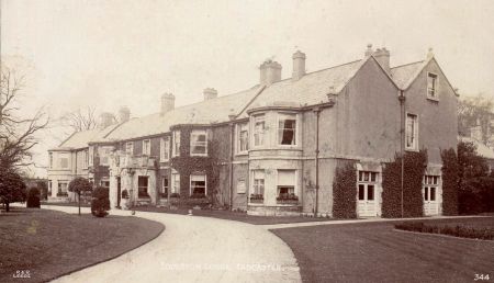
Postcard P&R Leeds, No. 344, Toulston Lodge viewed from west along drive, c.1920s
Tadcaster Grammar School Library (TGSL)
History by Gulielma Riccalton, extracts sent by Mrs Martin to school Headmaster 1821-1895
Bromet and Thorman bill for £3550.5s for work on interior of Toulston Lodge 1900
Plan Toulston Lodge grounds by H. Bennett, WR County Architect, scale ½ in to 1 ft 1948
Tadcaster Historical Society (THS)
A Map of Lordship of Towlston for George William Fairfax, 1760
03-D-02 Philippa Brooksbank’s diary (digital copy), 1781-1832
05-FE-13 1a Extracts concerning Headley Hall and Toulston Lodge from the history of the Tuke and Riccalton families by Gulielma Riccalton, 1821-1896
08-P-25a Toulston Lodge, pencil sketch, 1828
08-P-25b Photo of staff in front of south façade Toulston Lodge, 1886-1900
West Sussex Record Office (WSRO), Petworth House Archives (PHA)
3422 Survey of the manor of Tadcaster for the Earle of Nothumberlande,1611
West Yorkshire Archives Services, Leeds (WYAS)
WYL 2021 Toulston Estate Map,1761
Leeds University Library Special Collections (LULSC)
Yorkshire Archaeological & Historical Society Collection (YAS)
YAS/MD363/119D Memorial to register Deed of Enfranchisement,1864
Aerial Photograph
EPW016075 1926, https://britainfromabove.org.uk/en/image/EPW016075 accessed 18 October 2017
Maps
John Speed, map of West Riding of Yorkshire 1610
John Warburton, map of Yorkshire 1720
Thomas Jefferys, map of Yorkshire, plate 13, 1771
Ordnance Survey 6” surveyed 1845 to 1846, published 1849
Ordnance Survey 6” surveyed 1891, published 1895
Ordnance Survey 6” revised 1906, published 1909
Ordnance Survey 25” surveyed 1891, published 1893
Ordnance Survey 25” revised 1906, published 1909
Newspapers & Magazines
Durham Chronicle, 7 May 1858, 30 April 1858
Leeds Intelligencer: 29 September 1817, 31 March 1817, 18 September 1823, 14 September 1826, 2 October 1858, 19 July 1862, 9 July 1872
Leeds Mercury, 13 September 1823; 10 January 1824, 19 July 1828
The Tatler, 7 July 1909
The Gardener’s Chronicle 1910, Ser3, Vol 48, 169
Yorkshire Post and Leeds Intelligencer 2 June 1950, 31 December 1951
Figure 1 – Location of Toulston Lodge south of Toulston Hall and southwest of Tadcaster. Ordnance Survey one inch map, Leeds (Hills) Sheet 70, surveyed 1896, published 1898. Reproduced by permission of the National Library of Scotland, https://maps.nls.uk
Figure 2 – Touston village and Lodge on Jeffreys 1771 map. North Yorkshire County Record Office
Figure 3 – Toulston Lodge within Towlston Common on 1760 map. Tadcaster Historical Society
Figure 4 – Toulston Lodge south façade in 1828. Tadcaster Historical Society 08-P-25a, pdf copy of original sketch
Figure 5 – Toulston Lodge, service buildings, gardens and walled garden by 1846. Ordnance Survey 6” map, surveyed 1846-7, published 1849. Map reproduced by permission of the National Library of Scotland
Figure 6 – Toulston Lodge, service buildings, gardens and walled garden by 1891. Ordnance Survey 25” map, surveyed 1891, published 1893. Map reproduced by permission of the National Library of Scotland
Figure 7 – Extent of the parkland by 1906. Ordnance Survey 6” map, revised 1906, published 1909. Map reproduced by permission of the National Library of Scotland
Figure 8 – House and gardens with ha-ha, conservatory and glasshouses dividing the walled garden. Ordnance Survey 25” map, revised 1906, published 1909. Map reproduced by permission of the National Library of Scotland
Figure 9 – Toulston Lodge south facade and drive viewed from the east in 1920s. Postcard, Tadcaster Community Archive
Figure 10 – Walled kitchen garden, rose garden, conservatory and greenhouses on 1948 map. Tadcaster Grammar School Library
Figure 11 – Extent and changes to trees and woodland. Mapbase © OpenStreetMap Contributors, opendatacommons.org


