Upsall Park was once the site of a large (c. 600 acre) medieval deer park that was adjacent to a 14th century castle. Created between 1244 and 1255 by Geoffrey de Upsall, its boundaries can still be identified today and parts of its pale dike (boundary) remain. It was acquired by Geoffrey le Scrope in 1327 and his son, Henry, is believed to have built the castle on its northern edge sometime after 1350. Parks of this size were mainly owned by high status individuals and so would have been prized by the Scrope family.
The park’s long decline started in the 16th century when the estate was sold to the Constable family of Burton Constable. By 1600, it had been disparked and turned into farmland. However its boundaries remained intact as the land inside it was subject to a nominal tithe of 2 deer and the right of grazing on the land for one horse. Dr John Turton acquired Upsall Park in 1779 and improved the farmland but like previous owners did not live there. In 1860, Edmund Turton decided to build a new Upsall Castle on the site of the old one. He engaged the services of William Brodrick Thomas to landscape the grounds, including a new small park to the south, a terraced garden and walled kitchen garden. His son, Edmund, reinstated the former fishpond in the 1890s.
Estate owners
In 1066, Upsall formed part of the extensive landowning of Waltheof, Earl of Northumbria. He was executed in 1076 for taking part in a rebellion against William the Conqueror and by 1086, Upsall was in the hands of Count Robert de Mortain and tenanted by Richard de Surdeval. By the late 12th century, a family called ‘de Upsall’ were the tenants with the overall ownership passing from Richard de Surdeval’s son-in-law, Ralph Paynel, to the de Stutevilles:
Confirmation by William de Stuteville to Arnold de Upsall of the vills of Upsall, Kilvington and Thornbrough to hold by the service of a knights fee, as Ralph de Upsall his ancestor had held them of Ralph Paynel by the same service, 1191-4 (Farrer and Clay 2013, 106)
Geoffrey de Upsall sold the manors of Upsall and Over Silton, the advowson of the church at Kilvington and part of the manor of Kirkby Knowle to Geoffrey le Scrope of Bolton in 1327 for 100 marks (YAS 1910, 5). Two years later, le Scrope was forced to grant the manor of Upsall back to de Upsall for his life for an annual rent of one rose [i.e. no payment] by the order of the King (ibid, 6/7). De Upsall died in 1349 and Henry [1st Baron Scrope of Masham], Geoffrey’s son, took possession. It remained in the Scrope family until 1415 when the family’s lands were forfeited following the execution of Henry, 3rd Baron Scrope for treason. These were restored to Henry’s brother, John [4th Baron] in 1455.
The last male member of the Scrope family, Geoffrey [11th Baron] died in 1517. Three years later the Upsall estate passed to the family of Alice Strangways, Geoffrey’s sister. Following the death of her grandson, Sir James Strangways, in 1541 without issue, the estate was claimed by Robert Roos, his cousin. Strangways though had conveyed the manor of Upsall to the Dacre family just before his death (YAS 1887, 64) and so they disputed Roos’s claim. An award of June 1543 gave Roos Upsall manor and he later leased it, the castle and park to Ralph Tancred in 1566 (ERA DDCC/130/104). Tancred’s heirs transferred the lease to Sir Henry Constable of Burton Constable in 1574 (ibid). The Tancred family must have acquired the estate as they conveyed it to Edward Manners [3rd Earl Rutland] in 1575 (YAS 1888, 73), who in turn sold it to Constable in 1578 (ibid, 127).
The estate remained with the Constable family until 1768 when it was bought by William Chapman. Following Chapman’s death in 1773, the estate was once again put up for sale the following year and was bought by Dr John Turton in 1779 (NYCRO ZT I 6/1/1). Turton died in 1806 and he left Upsall to his wife. On her death in 1810, it was inherited by Edmund Peters, who changed his name to Turton in 1817. His descendants still own the property.
Key owners responsible for major developments of the designed landscape and dates of their involvement:
Geoffrey de Upsall (1244 – c.1282)
Henry le Scrope [1st Baron Scrope of Masham] (1349 – 1392)
Sir Henry Constable (1579 – 1607)
Dr John Turton (1779 – 1806)
Edmund Henry Turton (1857 – 1896)
Sir Edmund Russborough Turton (1896 – 1929)
Early history of the site
In the Domesday book of 1086, the area of Upsall, [North] Kilvington and Hundulfthorpe [Farm] was 6 ploughlands or c. 720 acres. The 3 villagers paid no tax but there was woodland of 1.5 leagues squared [possibly up to 20 square miles] (https://opendomesday.org/place/SE4587/upsall/, consulted 12 December 2019). Part of the woodland was to the south of Upsall, which was mentioned in an undated agreement [c. 1183 – 1203] between Adam Fossard, lord of Marderby [near Felixkirk to the south] and Arnold de Upsall, lord of Upsall, regarding the felling and removal of trees in Middlemore [Middle moor?] which lay undivided between their land and pasture. It was agreed that timber should be used both for building and none should be sold or given away except by mutual consent (Farrer and Clay 2013, 155).
Whether the de Upsalls had a manor house at Upsall is not known but Geoffrey de Upsall received a grant of free warren here on 6 February 1244 (PRO 1903a, 277). By 1255, he had a deer park as a command was given to William Herun, the chief justice for the forests north of the Trent, to give him three live bucks and seven live does from the royal forest of Galtres for the park of Uppesale [Upsall] as stock, a gift of the King (PRO 1931, 128). The size of this park is not known but it may well be the same as the later park that covered about 600 acres (Figure 1). If that was the case, it was relatively large as most non-royal parks at this time were between 100 and 300 acres (Liddiard 2007, 28).
Geoffrey’s grandson, also Geoffrey, appeared however to be having problems maintaining the stock in the park. On the 14 May 1325, he and his son John were accused of having:
‘fished in the king’s stanks [pools] and stews [ponds] at his manors of Kirkeby under Knoll [neighbouring Kirby Knowle] and Dighton and carried away fish, and entered his free warrens there and at his manors of Wath, Kirkeby Fleetham and Stapleton and his woods there and carried away hares, rabbits, pheasants and partridges from the warrens and deer from the woods’ (PRO 1904, 143).
1.3 Chronological history of the designed landscape
1.3.1 1327 - 1660
Following the sale of the manor to Geoffrey le Scrope in 1327, the new owner asserted his right to maintain the deer park with a ‘Grant of special grace to Geoffrey le Scrop[e] and his heirs of free warren in all their demesne lands in…Upsale [Upsall], Thornbergh [Thornbrough] and Kylvyngton [Kilvington]…October 28’ (PRO 1912, 91). The large size of the deer park may have been one of the attractions of Upsall for le Scrope.
When the manor reverted to Sir Geoffrey de Upsale for life the following year, an agreement was made on the 10 October between him and le Scrope re the woodland:
‘Indenture between Sir Geoffrey le Scrope and Sir Geoffrey de Upsale witnessing that, whereas the latter was holding the manor and wood of Upsale [Upsall] for life of the former’s inheritance by fine levied in the king’s court and the former had brought a writ of waste against the latter by reason of waste made in the said wood, the latter in order to have a release and quittance of the said waste surrendered to the former all the wood of Loftscough, Gildhousdale [in Felixkirk], Orberghraue with all the wood and coppices beyond the rabbit-warren (‘conyngger’) of Upsale on one side and the moor of Baggeby [Bagby] on the other, and the highroad extending from the south of the park of Upsale called Clivelandgate [possibly Cleaves, 3½ miles south east of Upsall] on one side and the lands of South Kiluyngton [Kilvington] and Tresk [Thirsk] on the other…it should be lawful for the former and his heirs to fell the said wood and coppices and remove timber at will, saving corn and meadows, and inclose them for purposes of cutting when the wood should be ten years old. In return the former quitclaimed to the latter all action of waste and trespass made by him and his men in the manor and wood. (YAS 1940, 150)
Figure 2 shows the possible extent of this woodland.
Once the Scrope family had taken possession again of Upsall, they maintained the deer park. Henry, Lord Scrope, brought an action against the Prior of Malton and others over their trespass in the park and killing of game there (YAS 1934, 86-7). The document is not dated but refers to either the 1st Baron Scrope (c. 1386 – 1392) or his grandson, the 3rd Baron (1406 - 1415). In 1393, Stephen [2nd Baron] and his heirs were granted free warren in his manors including Upsall by Richard II (PRO 1916, 335).
According to Grainge (1859, 265), the medieval Upsall Castle was built by either Geoffrey le Scrope or his son, Henry, around the middle of the 14th century on the site of the manor house of the de Upsalls. He offers no evidence for this but bases it on the style of architecture. Henry le Scrope gained possession of the manor in 1349, so this the earliest possible date for construction. No licence from the king to crenellate, indicating a castle, has been found for Upsall and Henry had other properties such as Clifton Castle for which Geoffrey le Scrope was given a licence to crenellate in 1317 (PRO 1903b, 26).
When Henry [1st Baron] died in 1392, there was no mention of the castle or the park in his Inquisition Post Mortem (Dawes et al. 1988, 109) nor in the descriptions of the property of Henry, 3rd Baron following his death in 1415, for example:
July 16 1438. To Robert Paynell esquire and James Flore esquire… of the keeping…the manors of Sylton [Silton] and Upsale [Upsall], 100 messuages, 24 cottages, 18 tofts, 3 carucates and 1000 acres of land, 200 acres of meadow, 1200 acres of pasture, 330 acres of wood…late of Henry late lord Lescrop, which are in the king’s hand (PRO 1937, 490).
When John [4th Baron] died on 15 November 1455, a codicil to his will written on 8 March 1453 stated: I bequeath to Thomas, my son and heir…all the stuff [i.e. possessions] in the manor of Upsall in every place and office there in, as is contained in an Inventory made on the [19 May 1452] (Raine 1855, 191). The office was a place of work, so could refer to buildings relating to the park and its maintenance such as lodges. The first mention of Upsall park is in the will of William Tanckard [Tancred] dated June 3 1573:
I William Tanckard…do give and bequeath to Ralph Tanckard…my whole term and lease of years which I have of the park of Upsall and other parcel of ground in Upsall, Thornbrough and Kilvington, the deer in the said park excepted. (Raine 1853, 236)
When Ralph Tancred and his sons leased the property to Sir John Constable, it was described as:
‘Upsall Castle, hemp-garth in which a dovecote stands, Little Corn Close, the kiln house, the water-mill in the Park and 3 closes; part of Wooll Moor (parcel of Upsall lordship) [Bell Moor?] with the coney warren and house there; the park pale and the woods of the lordship and a moiety of property as above’, 4 and 20 Dec 1574 (ERA DDCC/130/104).
This would indicate that the rabbit warren was outside the park to the south (Figure 1).
When it was sold to Constable in 1578, the estate consisted of ‘The Castle of Upsall and 16 messuages, 8 cottages and a watermill with lands and the privilege of frank-pledge in Upsall, also a third part of 3000 acres of moor in Upsall called Upsall Lowe moor als. Outwood’ (YAS 1888, 127). The ‘Outwood’ was probably the wooded area to the south first mentioned in the documents of the late 12th century.
In a survey conducted on Constable’s purchase, the park was said to be ‘660 acres of fine meadow and pasture’ (Grainge 1859, 279). By 1590, it was claimed the park now just consisted of a number of farms (Wood 1798, 450) and Grainge (1859, 279) stated the park had formally abandoned its purpose or been disparked in 1599. The park is shown on the c. 1645 map by Blaeu (Figure 3) although he may have based it on the earlier John Speed map of c. 1610. It contained two lodges as these are referred to in fieldnames listed in the 1773 survey (NYCRO ZT I 6/1/1) as transferred from Park [House] Farm to Matthias Gilbertson, the tenant of Castle Farm:
123 Great Lodge 9a 0r 12p
122 Little Lodge 4a 2r 16p
Gilbertson also acquired Park Hill, so they were near this (Figure 1) as lodges were often put on the highest ground (Liddiard 2007, 107). These fieldnames had disappeared by the time of the tithe survey of 1846 (TNA IR 29/42/396), so these buildings may have been demolished prior to 1773. A building is however depicted adjacent to the area called Park Hill on the 1st edition 6” OS map (surveyed 1853, Figure 4), so this may be the site of one or both of these lodges. This was removed when the new Castle Farm was built in the 1860s.
The castle too may have been declining in importance as on the 28 October 1577 there was a royal ‘grant to John Farnham, a gentleman pensioner, his heirs and assigns of…lands… including the old site of the castle, in Upsall…of Leonard Dacres, attainted of treason…and by yearly rents of 40s’. (PRO 1982, 322-3). Dacre had been one of those disputing Roos’ claim to Upsall. Further evidence comes from Camden’s Britannia: ‘At the foot of Kirkby Knole are the remains of Upsall Castle, once the seat of the lords Scrope of Upsall: the outer walls and round towers, and part of a large square tower yet remains.’ (Grainge 1859, 276). Camden visited Yorkshire in 1582, so his description probably dates from then. After the death of the Dowager Lady Dunbar in 1659 (YAS 1890, 150), the Constable family no longer used Upsall Castle as a residence.
1661 – 1860
By 1680, Richard Briggs was the tenant of the farm based at the former Upsall Castle (Atkinson 1884, 42) with his son, Richard, listed as a Catholic non-juror in 1715 (Estcourt and Paine 1885, 323). Upsall Castle is depicted but no park is shown on Warburton map of c. 1720 (Figure 5). Further evidence that it had been disparked by this stage is the following statement of the tithe due to the rector at Kilvington now paid in money:
‘in the year 1681 Lord Dunbar was then the owner of the Park Farms…[and] he had compounded with the then rector of the parish [of South Kilvington] to pay £23 pa for all the tithes in township of Upsall and Upsall Park [in lieu of modus i.e. 2 deer and grazing rights]’ (Wood 1798, 448).
In 1763, William Constable put up the estate for sale. It was advertised as:
Situated at Upsall in the County of York… THE Manor of Upsall aforesaid, with the capital Mansion-House there, and several farms of Arable, Meadow, and Pasture Ground, containing in the whole 1339 Acres. The Farm Houses on both the Estates are in very good condition, and the Farms well tenanted… The said John Briggs, of Upsall aforesaid, will show the Premises (The London Chronicle, 11 August).
Five years later, it was finally sold to William Chapman of Oulston and Jeffrey’s map of c.1771 (Figure 6) indicated Upsall as a ‘ruined castle’ and no park was shown. An estate survey of 1773 gave the total area of 1233a 3r 22p, with the park 597a 3r 14p and also mentioned ‘the old castle and orchard and an out boundary around the park in some places about 8 or 9 yards wide called Pale Dike’ (Grainge 1859, 279).
On purchasing the property in 1779, Dr John Turton was determined to improve the estate. Perhaps he intended to live there for part of the year as he wrote on the 13 February 1781: ‘I am not without thoughts of some time myself a house at Upsall - as far as I recollect the site, or situation wou'd be in Hurwoods Farm’ (NYCRO ZT I 6/1/1). This was to the north of the old castle and village road and later called Upsall Farm. Within the former deer park, there were three farms: Castle Farm, Park Farm (later called Park House) and Low Farm (possibly the one later called Nevison House). In the northern part of the township was Wilkinson’s Farm (later North Farm).
There was a small area of common (56 acres) north of the castle, which Turton wanted to enclose (NYCRO ZT I 1/1/1) and turn into productive farmland. He also had some old trees removed from the park in 1783 and a nursery set up to grow on new trees. John Reed, his agent, informed him on the 5 March of that year:
Yesterday I was at Upsall, where we are much hindered in planting the Nursery by the severe frosty weather…and the trees will soon be planted if the weather do but favour us. I have sold the wood to the two tanners in Thirsk…for £510 pounds…besides clearing the ground of many trees that do much harm, I have added to the wood I proposed planting 50 Lombardy poplars and 50 Spanish Chestnuts where they thrive, grow fast and are useful in repairs (NYCRO ZT I 1/1/1).
That year, he bought the following trees:
400 ashes [2 feet] and 600 oaks [3 feet] from Telfords of York, 25 February (NYCRO ZT I 1/1/13/6)
600 oaks [3-5 feet], 200 ashes [ditto], 50 Spanish Chestnuts [ditto], 50 Lombardy Poplars [ditto] from William Thompson of Pickhill, 3 March (NYCRO ZT I 1/1/13/11) and 260 Scotch Firs from John Bell, 11 March (NYCRO ZT I 1/1/12/3)
These were used to create new plantations along the northern beck that ran through the park in 1785, as on the 16 March John Reed, advised him: ‘The season has been so exceedingly contrary that I have only planted 500 oaks in the nursery and along the Beck sides in John Fawcett’s and Philip Nelson’s Beck Closes’ (NYCRO ZT I 1/1/1).
The 1806 map shows this new woodland, together with planting to the north of the former common and an area in the south east park of the park called Ella Carr (Figure 7). By the 1st edition 6” OS map surveyed in 1853, the designed landscape had not changed.
1860 – 1875
When Edmund Henry Turton inherited the property in 1857, he decided to make a new residence for himself on the site of the old castle. He engaged the services of the architects Hadfield and Goldie of Sheffield and London. George Goldie had been influenced by Augustus Pugin and the Gothic Revival. His main work was on religious buildings, particularly Catholic churches. He and Hadfield produced plans for a new Castle Farm in July 1860 (NYCRO ZT I 8/2/1) that was to be built to the south, so the old Castle Farm could be demolished (The Builder, 8 September 1860).
Turton then turned his attentions to the immediate landscape, engaging the designer William Brodrick Thomas to lay out the kitchen garden and grounds in 1862 (The Builder, 28 June 1873). Thomas later worked at Sandringham, Dalton Hall and Hutton Hall in the 1870s, where he introduced a more formal style of gardening.
In 1863, the kitchen garden complex was built. On the 1 January, Edmund Turton wrote to an unknown correspondent:
Mr Goldie has sent me a plan of a kitchen garden wall proposed by Mr Broderick [sic] Thomas. I fear it is too elaborate for the sum I should like to invest upon it. The length is right although yesterday I told Mr Goldie it was not, namely 206 feet. The gateway is rather too wide 8 feet. Would a reduction reduce the expense? I make no doubt you can see Mr Goldie’s office plan so write accordingly. Walls of cottage on east and south sides and all internal walls to be omitted altogether. Walls on west and north sides of cottage to be carried at 9 feet and temporarily covered with rough coping found by me…the building to be begun on 7 of April weather permitting and completed by 30th of May (NYCRO ZT I 6/1/2)
The hothouse range of buildings were supplied by Ash & Company of Sheffield, with the heating system by J & C Ellis of the Norfolk Foundry, also of Sheffield (see Section 4.9). However the Gardener’s house [later Garden House] was not completed until late 1870 (NYCRO ZT I 6/1/4). In 1866, the houses around the green to the north and west were removed and a garden wall was built facing the village green (NYCRO ZT I 6/1/3). By 1870, a sunk fence had been put in between the site of the new Castle and the walled kitchen garden (ibid) and Turton started ordering trees for planting on the estate:
November 1870 20,000 larches (1½ to 2 feet), 1 Cedar Deodar, 1 lime and 1 variegated sycamore from Edward Taylor of Malton (ibid)
November 1871 20,000 larches (2 feet), 1 variegated sycamore, 1 walnut, 1 silver holly and 50 privet from Edward Taylor (NYCRO ZT I 6/1/4)
In addition, there was a bill for ‘Forest Trees’ from James Backhouse of York costing £4 10s 9d in December 1871 (NYCRO ZT I 3/1). More larches were bought from Edward Taylor (January 1872) and 23,000 larches in December 1873, together with 5,000 Scotch Firs (ibid), although it is not clear whether these were for Upsall or his other estate at Roxby.
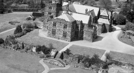
Between 1871 and 1873, three new entrance lodges were built, together with Upsall Grange to the south of the North Lodge. In 1875 the new Castle was completed and the Turton family moved in. That year the gardens around the new building were finished with a terrace incorporating the remains of the old castle wall. On the 4 January, Edmund Turton wrote that: ‘I have agreed with Pickering to level the plot before the old ruin and it will require a retaining wall from such old ruin to the east sunk fence wall that Kirk built leaving a space for steps 5 feet long. I apprehend there is stone enough lying about to do the job’. (NYCRO ZT I 6/1/4) The layout is shown on the 1st edition 25” OS map surveyed in 1892 (Figure 8).
By 1892, a new ‘Upsall Park’ had been created. This was an area of just under 63 acres to the south of Upsall Castle (Figure 9).
Later history
The largest of the three former fishponds was reinstated, with a boathouse added on its western edge, between 1892 and 1910. Beyond the walled kitchen garden to the east, the Boundary plantation was added between the Paled Dike and parish boundary (Figure 9). A new entrance was made opposite the village green, presumably to gain access to the new service buildings.
Upsall Castle was largely destroyed by fire in 1918 and rebuilt five years later on a smaller scale. The designed landscape was unaffected and remains largely unchanged a century later.
Location
Upsall Park is south of the village of Upsall and about 3 miles northeast of Thirsk.
Area
The historic park and landscaping to the north east of the Castle and village is c. 770 acres (312 hectares).
Boundaries
The western boundary starts at SE 452 880 and continues south until it meets the road next to North Lodge. It then follows the village road south past Upsall Castle and Park Lodge until it meets the pale dike at SE 446 860. The final western section follows the pale dike south from the road until it crosses the Beechpath Beck when it is formed by the parish boundary to SE 455 842. The southern boundary continues to follow the parish line until SE 466 853, where it meets the pale dike. The eastern boundary is formed by the pale dike until SE 458 868, where once again it follows the parish boundary to the north at SE 457 882. The short northern boundary is along the parish line until SE 452 880.
Landform
The underlying bedrock is Redcar Mudstone Formation across the lowland parkland. Around Castle Farm, this changes to Staithes Sandstone, then Cleveland Ironstone Formation and finally Whitby Mudstone on the higher levels. This is overlaid with deposits of uneven sized glacial tills giving rise to slowly permeable, seasonally wet and slightly acid but base-rich loamy and clayey soils. Two main watercourses (Beechpath Beck and Nevison’s Beck) flow onto the lower ground from the hills above.
Setting
Upsall Park is in the Vale of Mowbray, an area of lowland farmland next to the Hambleton Hills and the North York Moors. The land slopes up from west (c. 50m OD) to east (c. 120m OD) and from south (c. 70m OD) to north (c. 200m) with Upsall Castle at 128m AOD. The former deer park slopes away from the Castle with Dovecote Hill the highest point at 120 AOD, Park Hill further south is 110m AOD.
Entrances and approaches
Upsall Lodge [or New Lodge]
On road from South Kilvington to Upsall at the start of the area known as Upsall Park created in late 19th century, with a carriage route past Castle Farm through the park to east side of Upsall Castle. Probably built in 1871, together with the North Lodge, which has a datestone on the façade. There is a reference to the building costs of the ‘lodges in Upsall Castle’ in the letterbook (NYCRO ZT I 6/1/4) following a letter dated 28th December 1871.
Main Entrance
Opposite village green, it was constructed between 1892 and 1910 when additional service buildings were added to the north of the new Upsall Castle.
Gatehouse to walled garden [Grade II – NHLE 1241656]
Presumably built at the same time as the kitchen garden walls in 1863.
Park House Lodge
On road from South Kilvington to Upsall and giving direct access to Park House. Built between 1853 and 1892.
North Lodge
Built in 1871, it gives access to the woods to the northeast.
Principal buildings
Upsall Castle [medieval, Grade II – NHLE 1241639; scheduled monument no 1008734]
No exact date has been found for its construction but the layout on the 1806 map would suggest it was constructed in the mid to late 14th century. Some of the northeastern parts were converted into farm buildings by the 1770s (Castle Farm) but these were knocked down in 1866. Part of the walls to the south and west remain and are listed.
Upsall Castle [19th century]
Built between 1871 and 1875 to the designs of Goldie and Child. Destroyed by fire in 1918, it was rebuilt in 1923.
Old Castle Farm
Formed from the remains of the medieval castle and removed in 1866 to make way for new Upsall Castle.
Castle Farm [Grade II – NHLE 1241625]
Built c. 1860 to a design by Hadfield and Goldie in the former deer park as a replacement for the farm that occupied the old medieval castle site.
Park House
Remodelled in 1866 by Goldie (NYCRO ZT I 8/2/3), it dates from at least 1773 when it was detailed in the survey.
Nevison House [Grade II – NHLE 1260592]
This has a datestone of 1666, although as the date precedes the present house of clearly C18-19, it may date from earlier. It is adjacent to the former rabbit warren and a house is mentioned there in 1574 when the lease was transferred to William Constable.
Great Lodge
Possibly associated with the medieval deer park, name used for an area in 1773 survey near Park Hill.
Little Lodge
Possibly associated with the medieval deer park, name used for an area in 1773 survey near Park Hill.
Gardener’s House [Grade II – NHLE 1260593, named as Garden House]
Completed in 1870, adjacent to the walled kitchen garden
Gardens and pleasure grounds
Gardens of medieval Upsall Castle
Grainge (1859, 269/70) gives a description of these: ‘Before the western front lay the pleausance which were singularly rich and fertile, one portion was styled “My Ladies Vineyard”. Another bore the name of “St Cecilia’s Grove”…In the grounds was also a maze or labyrinth, known by the name of “the Puzzle Bush”. A large weeping elm which grew in the garden was called “Rosalind’s Bower”. He does not give a reference, so it is hard to verify these, although it is possible that they came from the 1578 survey. Features such as vineyards, mazes and orchards were found in high status medieval gardens (Creighton 2009, 73-77). On the tithe apportionment, the area to the west of the castle (No 195) is called ‘Old Bess’ and the area next to it is described as ‘Homestead and Orchard’.
Late 19th century gardens
The site of the former Upsall Castle was landscaped between 1862 and 1875 to plans by William Broderick Thomas. Part of the old castle wall was used and this formed part of the higher terraced area (Figure 10). There was a small pavilion or seat on the lower terrace to the west. Between the Castle and the kitchen garden were the pleasure grounds.
Kitchen garden
The walled kitchen garden was constructed in 1863 to the design of William Broderick Thomas and covered 0.8 acres. To the east lay an orchard of just over ¾ acre (Figure 8). The glasshouse range supplied by Ash & Co. contained a conservatory 30 x 16 feet, 2 vineries 20 x 14 feet and 2 peach houses 20 x 14 feet. At the rear was a mushroom house. To the north, next to the road was a camellia house 18 x 16 feet (the larger of the two buildings marked on Figure 8). There was also a cucumber bed whose position is unknown (NYCRO ZT I 6/1/2).
In 1896, a new conservatory was proposed as a replacement for the one above by William Richardson & Co of Darlington (NYCRO ZT I 8/2). It is not known whether it was built.
Park and plantations
Upsall medieval park [scheduled monument no 1010804]
Created in the mid 13th century, the boundaries at the time of disparking c. 1599 are shown on Figure 1. Parts of the park pale remain and are described in the Historic England’s listing:
The Pale itself survives in its most complete form as an earthen bank 5m across and 1m high, with an internal ditch with a span of about 2.5m. It is assumed that the bank was originally surmounted by a timber palisade, thus providing an effective stock barrier. Today the Pale survives best where it has been incorporated into modern field boundaries, most easily seen along the eastern edge where it is marked by a line of mature trees. Variations on this form include less well-preserved sections of bank and ditch, lengths of ditch only, lengths where the earthwork boundary has been ploughed flat, one section of probable double-bank and substantial lengths where no earthwork survives but the Park boundary is marked by a steep-sided stream. It is these natural boundaries which have given the Park its irregular outline compared with more regular examples with entirely artificial boundaries. The sections chosen for scheduling are the best-preserved lengths of pale. https://historicengland.org.uk/listing/the-list/list-entry/1010804, consulted 25 March 2020
Water
Grainge (1859, 278) claimed that four of the former fishponds south east of the Castle were visible due to their lower level and richer green of grass. The 1st edition OS map surveyed in 1854, shows a large area with a smaller connecting piece to the south described as ‘remains of Fish Ponds’, together with the southern and western parts of the moat (Figure 11). The largest of these was reinstated sometime between 1892 and 1910.
Some further remains of fishponds are identified on the old OS maps to the north west of Park House (SE 449 857).
Books and articles
Atkinson, J.C. ed. 1884. Quarter Sessions Records, Vol VII. London, The North Record Society.
Creighton, O. H. 2009. Designs Upon the Land: Elite Landscapes of the Middle Ages. Woodbridge, The Boydell Press.
Dawes et al. 1988. Calendar of Inquisitions Post Mortem, Volume 17, Richard II. London, HMSO.
Escourt, Rev. E. E. and Payne, J.O. 1885. The English Catholic Non-Jurors of 1715. London, Burns & Oates.
Farrer, W. and Clay, C. T. 2013. Early Yorkshire Charters: Volume 9, The Stuteville Fee. Cambridge, Cambridge University Press.
Grainge, W. 1859. The Vale of Mowbray: a historical and topographical account of Thirsk and its neighbourhood. London, Simkin Marshall & Co.
Liddiard, R. ed. 2007. The Medieval Park: New Perspectives. Macclesfield, The Windgather Press.
PRO 1903a. Calendar of the Charter Rolls. Henry III, 1226-57. London, HMSO.
PRO 1903b. Calendar of the Patent Rolls. Edward II Volume 3, 1317-21. London, HMSO.
PRO 1904. Calendar of the Patent Rolls. Edward II Volume 5, 1324-7. London, HMSO.
PRO 1912. Calendar of the Charter Rolls. Edward III Volume 4, 1327-41. London, HMSO.
PRO 1916. Calendar of the Charter Rolls Volume 5, 1341-1417. London, HMSO.
PRO 1931. Close Rolls of Henry III, 1254-1256. London, HMSO.
PRO 1937. Calendar of the Fine Rolls, Volume 17, 1437-45. London, HMSO.
PRO 1982. Calendar of the Patent Rolls, Elizabeth I, Vol VII, 1575-78. London, HMSO.
Raine, J. 1853. Wills and inventories from the registry of the archdeaconry of Richmond. Durham, The Surtees Society.
Raine, J. ed. 1855. Testamenta Eboracensia, Part II. Durham, The Surtees Society.
Wood, H. ed. 1798. A Collection of Decrees by the Court of Exchequer in Tithe-Causes. Volume 3. London: Bunney, Thompson & Co.
YAS 1887. Feet of Fines of the Tudor Period Part 1, 1485-1571. Leeds, The Yorkshire Archaeological Society.
YAS 1888. Feet of Fines of the Tudor Period Part 2, 1571-1583. Leeds, The Yorkshire Archaeological Society.
YAS 1890. Abstracts of Yorkshire Wills in the time of the Commonwealth. Record Series No. 9. Leeds, The Yorkshire Archaeological Society.
YAS 1910. Feet of Fines 1327–47 for the County of York. Record Series No. 42. Leeds, The Yorkshire Archaeological Society.
YAS 1915. Yorkshire Fines for the Stuart Period Vol 1, 1603-14. Record Series No. 53. Leeds, The Yorkshire Archaeological Society.
YAS 1934. Monastic chancery proceedings late 14th century – 1540. Yorkshire, Record Series No. 88. Leeds, The Yorkshire Archaeological Society.
YAS 1940. Yorkshire Deeds Vol VIII, Record Series No 102. Leeds, The Yorkshire Archaeological Society.
Primary sources
East Riding Archives (ERA)
DDCC/130/104
Lease: Robert Rosse [Roos] to Ralph Tancred: Upsall Park; parcel in Upsall Field called Littlewath; parcel in Thornburgh called Lords Ing or Cringlekarr, 12 Nov 1566
Lease: Robert Rosse to William Tancred: manor of Upsall with appurtenances in Upsall, Thornbrough and South Kilvington, 12 Nov 1566
Assignments: Ralph Tancred and his sons William, Richard, Charles and Henry to Sir John Constable: Upsall Castle, hemp-garth in which a dovecote stands, Little Corn Close, the kiln house, the water-mill in the Park and 3 closes; part of Wooll Moor (parcel of Upsall lordship) with the coney warren and house there; the park pale and the woods of the lordship and a moiety of property as above, 4 and 20 Dec 1574
North Yorkshire County Record Office (NYCRO)
ZDU[1]42 Jeffrey’s map of Yorkshire c. 1771
ZPI Map of Upsall, 1806
ZT I (Papers of the Turton family of Upsall)
1/1/12-25 Accounts and Vouchers for Upsall and Balk, 1783 – 1788
3/1 Cashbook 1857 - 1875
6/1/1 Letterbook 1779 – 1806
6/1/2 Letterbook 1853 – 1863
6/1/3 Letterbook 1863 – 1871
6/1/4 Letterbook 1871 – 1881
8/2 Plans and designs for Upsall Castle, 1860 – 1896
8/2/1 Plan for Upsall Farm buildings, Hadfield and Goldie, July 1860
8/2/3 Designs for Park House Farm, December 1865
The National Archives (TNA)
IR 29/42/396 Tithe apportionment for Upsall (parish of South Kilvington), 26 January 1846
IR 30/42/396 Tithe map for Upsall (parish of South Kilvington), 1846
Maps
Ordnance Survey 1” revised edition, surveyed 1896, published 1898
Ordnance Survey 6” 1st edition, surveyed 1854, published 1857
Ordnance Survey 25” 1st edition, surveyed 1892, published 1893
Ordnance Survey 25” revised edition, surveyed 1910, published 1912
Figure 1 – Tithe map of Upsall, 1846 showing Upsall Park and features associated with medieval landscape. Source: The National Archives
Figure 2 – Possible extent of woodland in 1328. OS 1” map, revised 1896, published 1898. Reproduced by permission of the National Library of Scotland.
Figure 3 – Upsall Castle and Park on J. Blaeu’s map of Yorkshire c. 1645
Figure 4 – Possible park lodge. 1st edition 6” OS map, surveyed 1854, published 1857. Reproduced by permission of the National Library of Scotland
Figure 5 – Upsall Castle on John Warburton’s map of Yorkshire c. 1720
Figure 6 – Upsall with ‘ruined castle’ on Jeffrey’s map of Yorkshire c. 1771. Source: North Yorkshire County Record Office.
Figure 7 - New plantations in park along stream and Ella Carr (top) and north of former common (bottom) from 1806 map of Upsall estate. Source: North Yorkshire County Record Office.
Figure 8 – New Upsall Castle, terraced gardens, pleasure grounds, walled kitchen garden and orchard. 25” 1st edition OS map, surveyed 1892, published 1893. Reproduced by permission of the National Library of Scotland.
Figure 9 – New Upsall Park and fishpond. Revised 25” OS map, surveyed 1910 and published 1912. Reproduced by permission of the National Library of Scotland.
Figure 10 – Rebuilt Upsall Castle and its immediate gardens, 1949. Source: www.britainfromabove.org.uk/image/EAW022506. Copyright Historic England
Figure 11 – Location of former fishponds and moats. 1st edition 6” OS map, surveyed 1854, published 1857. Reproduced by permission of the National Library of Scotland.


