Womersley Park was first developed by Tobiah Harvey from about 1703 and has remained in the ownership of his descendants until a break-up of the estate through a sale in 1930. The house and gardens remained in the family ownership until 2004. Womersley estate is a site of 144.5 hectares (357 acres) bounded mostly by a shelter belt plantation and partly by magnesian limestone walls.
The grade II* listed House along with garden and historic parkland occupied 48.6 hectares (120 acres) Tobiah Harvey planted a walled garden over about 20 years, with records surviving of his purchase of plants and seeds. The walled gardens were developed over time to occupy just over 2 acres at their largest extent. External walls of the walled gardens remain in situ, along with one internal wall, all dating from earlier than 1805. The walled gardens have developed as part pleasure garden, part productive garden. While just over half has remained as walled gardens, just under a half had houses built on in the 1980s.
Part of the estate was developed as parkland, starting in the mid-18th century and resulting in its largest extent in late Victorian times, complete with icehouse, ha-ha and carriageway. The parkland was broken up into different lots in the sale of 1930. Part of the parkland, which is now not in ownership with the house and gardens, contains scheduled remains of the medieval village as well as the Victorian icehouse. With the marriage of Lord Rosse to Anne (nee Messel) in 1935 there are family links to the renowned gardens of Nymans and Birr Castle. There are no surviving features on the estate containing water, apart from natural streams, which form part of the boundaries with Womersley Beck flowing through the northern part of the parkland. A lake was created in the 18th century and fishponds in the 19th. There seem to be no surviving records of any designers or landscape architects for the gardens or parkland.
The house and gardens, but not the historic parkland, lie within the Womersley conservation area.
Estate owners
Womersley parish was recorded as Wilmeresleia in the Domesday Book of 1086 as a possession of Ilbert de Lacy, who built Pontefract Castle. ‘By the early 12th century it was in the hands of Otes de Tilley, passing through marriage to the de Newmarch family in 1183’ (NHLE (National Heritage List for England), 1017824). Womersley continued through the Newmarch line via the Nevilles and Gascoignes to, in the 1600s, the Twistletons and the Jacksons (Hind 2005, 7-10).
There appear to have been two manors in Womersley parish in the 1630s: – Woodhall, centred on a moated manor house in the north of the parish, owned by the Twistletons; and Womersley manor, owned by Sir John Jackson, M.P. of Hickleton and Womersley (Hind 2005, 10). William Harvey, a London vintner, bought Woodhall manor in the mid 1600s and with his son, Tobiah Harvey (snr) managed the area around Woodhall. Tobiah Harvey (snr) died about 1663. The Womersley manor was sold to William’s grandson, Tobiah Harvey (jnr) in 1680 by Bradwardine Jackson (Hind, 2005 p22). Tobiah Harvey (jnr) was a Fellow of Clare College, Cambridge in 1676, admitted to The Middle Temple in 1677 and called to the Bar in 1686. Tobiah Harvey (jnr) thus inherited much of Womersley parish but was an absentee landlord until he built Womersley Hall in 1702.
Part of the Womersley estate was first developed as a designed landscape by Tobiah Harvey (jnr) in the early 18th century. The estate passed down the Harvey family line, firstly to Tobiah’s son, William Harvey (d 1739) then to William’s son Stanhope Harvey who later became a Colonel of 2nd West Yorkshire Militia (1723-1797). In 1739 Stanhope was 16 and unable to act. In 1742 when his mother Isabella died he was not yet 20, but he had plenty of advisers, including uncles Patience Warde at Hooton Pagnall, George Cooke at Streethouse and Thomas Yarborough at Campsmount (Hind 2005, 25). Stanhope’s wife and sons pre-deceased him, leaving his daughter Frances Harvey (1772-1810) as lady of the manor on her father’s death in 1797. Already betrothed to Edward Hawke (1774-1824), 3rd Baron Hawke and grandson of the famous Admiral Hawke, Frances Harvey married him in 1798 with the couple taking the name Harvey-Hawke. The estate was inherited in 1824 by their son Edward William Harvey-Hawke (1799-1869). By his second wife Frances Featherstonhaugh (1822-1903), Edward William had a daughter Frances Cassandra Hawke (1851-1921), who inherited the estate on his death. Frances Cassandra Hawke, married Laurance Parsons 4th Earl of Rosse (1840-1908) of Birr Castle, Ireland, in 1870. Lady Cassandra Rosse and her family were very frequently in residence until her death in 1921. Some of the larger estate was tenanted since Tobiah Harvey’s initial purchase and in the 1920s the house and immediate parkland were also let. In 1930 the whole estate was put up for sale, with some of the tenanted parts being bought. However, the house and immediate parkland remained unsold, staying in the Parsons (Lord Rosse) family until 2004, when the house and immediate parkland were sold. The house and gardens are now in private ownership.
Key owners:
- Tobiah Harvey (1659-1720)
- Lord Edward Harvey-Hawke (1774-1824) & Lady Frances Harvey-Hawke (1772-1810)
- Lord Edward William Harvey Hawke (1799-1869) & Lady Frances Harvey-Hawke (1822-1903)
- Lady Frances Cassandra Rosse (1851-1921) & Lord Laurance Rosse (1840-1908)
Early history of the site
Finds within the parkland of stone (NRHE (National Record of the Historic Environment) 56074) and flint tools (NY SMR Number MNY9931) are evidence of prehistoric activity in the area. Within the park and the wider landscape there is extensive evidence for Iron Age and Roman settlement from excavations and aerial photographs recording cropmark enclosures, trackways and field systems (e.g. NRHE 56080). Roman pottery finds and iron slag, located between Lady Hawke Wood and The Rookery, further support this.
St Martin’s church, mainly 13th century in origin, is thought to be the centre of the relatively large medieval village (85 people over the age of 14 recorded for the 1379 poll tax). Womersley Hall was built in the early 18th century, immediately to the east of the church, with the remains of the medieval village to the west. Earthwork remains of part of the medieval village are a scheduled monument in part of ‘Icehouse Park’ in the north-western part of the designed landscape (National Grid Reference: SE 52807 19086) (NHLE 1017824).
Chronological history of the designed landscape
The Womersley estate initially comprised the whole village including farmland, limestone quarries, woodland, houses etc. Although some parts were sold at different times, much of the village remained in the possession of Tobiah Harvey’s descendants until the major sale in 1930.
The part of Womersley village which is considered to be the designed landscape, Womersley Park, is that bordered by plantations and detailed in part 4. (See Figure 4 for the landscape in the late 19th century)
1705-1720
Womersley Hall was constructed about 1702-3, probably on the site of an existing house as the cellars are 17th century (NHLE 1316344; Pevsner 1967, 651).
In a land survey book of 1700 (BIHR WOM 1/1/1/1), Tobiah Harvey is shown as owning, amongst other pieces of land: house, gardens & orchard 1.17 acres (1 acre 0 r 27p); New Close 6.44 acres.
Tobiah Harvey’s detailed accounts from 1705 until his death in 1720 still survive (BIHR WOM 2/4/1). In the accounts are full details of the plants and seeds he purchased and some indication of the location of the planting of fruit trees near the house. Holly setts and yew for hedging were bought. This period may have seen the tentative beginnings of some parkland laid out, as there are records of 21 elms being bought in 1710, 16 elms and 9 Dutch limes in 1712 and, in 1720 from "John Perfect 4 english elms 10ft high to give another if one dies" (BIHR WOM 2/4/1). No plans or details of park or pleasure garden survive.
From 1705 to 1720 Tobiah Harvey developed a walled garden, buying fruit from Noah Perfect of Pontefract and many types of vegetable seed. A substantial walled garden, possibly already sub-divided, was in place by 1720 (see section 4.9) and overseen by named gardeners: Rowland Wood (1705-07 paid £10 p.a.); Thomas Hooton (1707-15 £13 p.a.); Joseph Perfect (1715-17 £12 p.a.); William Stephenson (1717- ? £12 p.a.).
1720-1824
There are limited records available for the period of ownership of Tobiah Harvey’s son, William, and grandson, Stanhope. However, it would appear that there was continued and gradual development of the designed landscape to include further plantations, a lake, extension of the walled garden and possible parkland. Although there is no direct documentary evidence, we can suppose that there was a continued connection with the Perfect family of nurserymen, started by Tobiah Harvey, possibly in advising on the landscaping. Thomas Yarborough (1687-1772) at Campsmount Park, about 8 kms south of Womersley Park, was one of the advisers to Stanhorpe Harvey when he inherited the estate but before he came of age. Yarborough was responsible for the creation of the large scale ornamental parkscape at Campsmount. ‘The landscaping of Campsmount Park was "improved" by Joseph Perfect who is first mentioned as supplying trees and garden seeds to the estate but then is paid to for levelling and planting of vistas on Hawkhill and Cliffhill, as well as the building of a summer house on a planted avenue on Hawkhill in the late 1720s’ (Doncaster Council Report on Campsmount Park 2013).
A tantalising glimpse of the gradual development, started by Tobiah Harvey, is provided by the diary of John Baker who visited William Harvey in June 1728 and saw some of the ongoing changes e.g. 12 June 1728 ‘Stayed but a little time in the Low Fold however made up the loss of that time in visiting some workmen mending Stoop & rail which kept us two hours. Saw his new plantation of Firs’ (Bucks D/X 1069/1/2). There is also a suggestion that a lake was constructed in the mid 18th century according to Rev. William Stukeley’s diary (NRHE 56074; Surtees Society 1887, 363-4): ‘A stone "hand axe", in the possession of a Mr Drake, was found when digging a new fishpond at Womersley before 1750.’ Certainly a sinuous lake or pond shows on the 1805 enclosure map and is the only lake or pond in Womersley at that time (WYA WRRD B 23).
The outline of a park is shown on John Dickinson’s map of 1750 but there is no indication of parkland on Jeffrey’s 1771 map or John Carey’s 1789 map.
The 1805 enclosure map (WYA WRRD B 23) shows a belt plantation running around the top half of the estate, with the beck and road forming a natural boundary around the rest of the estate. It is possible that some of the belt plantation was laid out in the mid-1700s or earlier at the time of Tobiah Harvey. Two further plantations existed by 1805, one on the natural rise to the west of the house and one on the western edge of the estate (not visible from the house).
A land survey valuation was carried out in 1788 (BIHR WOM 1/1/1/3). This survey shows Stanhope Harvey with a house, barn, stable and two garths totalling 1 acre. If the two garths are the walled gardens, then evidence suggests that the walled gardens were extended to 2.15 acres between 1788 and 1805 (1805 enclosure map WYA WRRD B 23). The house was also extended by adding a wing in the late 18th century, possibly during Stanhope Harvey’s or Lord Edward Harvey-Hawke’s ownership.
The evidence thus suggests that during the latter part of the 18th century there had been gradual development of the estate, with expansion of house and gardens. The designed landscape in 1805 showed the footprint for further development in Victorian times – that part of the estate which was visible and accessible to the west, south and east of the house. There was a nascent parkland to the south west of the house with a lake; two walled gardens were to the north-east; an orchard or wooded area to the immediate east; and a sweeping driveway to the south (1805 enclosure map WYA WRRD B 23). (Fig 2)
1824-1892
By the 1840s parkland had clearly been developed. A New Park is shown on the 1st edition 6” 1853 Ordnance Survey map. Although no relevant records can be found from the time of the 3rd & 4th Barons Harvey-Hawke (Edward and Edward William), it is possible that the New Park was developed under Edward William Harvey-Hawke, after he inherited the estate in 1824. The New Park occupied the north-east third of the estate, in line with the field boundaries shown on the 1805 enclosure map, and similar to possible boundaries on the 1750 Dickinson map. By 1848, the belt plantation surrounded the entire estate. Two further plantations were shown on the estate -Top Plantation (now called The Rookery) and Oak Plantation corresponding to the two plantations shown on the 1805 enclosure map.
A track is shown on the 1st edition OS map running from the south of the house through parkland to the west to exit on Pontefract Gate (Figs 3 & 4). This track allowed carriage access from the extreme north western end of the parkland. This carriageway from the Pontefract road was in addition to the existing carriageway running south east of the house to the Doncaster road (1805 enclosure map).
Sometime between the surveying for the 1853 and the 1892 OS maps, the parkland was developed further. An ice-house featured in the centre of the parkland amongst trees to the north of the carriageway from Pontefract gate, which had a substantial gate lodge by then. However, the lake between the carriageway and the beck, depicted as marshy ground on the 1853 OS map, is not shown from 1892 onwards. A small area of pleasure ground had been added just to the south east of the house, possibly lawn surrounded by shrubbery, and at some point became the tennis lawn listed in the later 1930 sale plan. A ha-ha had been constructed extending from the eastern carriageway to this pleasure ground, then to the west and south west up towards the Rookery plantation (1892 25" OS map). Lady Hawke wood was also laid out to the south west of the house, from which there were then views of immediate parkland with woodland (Lady Hawke wood and Rookery Plantation) on the skyline. By 1892 a gate lodge had been built at the Pontefract Gate.
The scheduled monument description (NHLE 1017824) indicates that the parkland and icehouse were laid out in 1867, although no source for this date is cited. It is surmised that Lady Hawke Wood is named after Lady Frances Harvey-Hawke (1822-1903), 2nd wife of Edward William Harvey-Hawke and that the parkland was laid during Edward William Harvey-Hawke’s ownership.
Earlier than 1861, a gardener’s house was built as an attachment to the north-west corner of the productive walled garden. Census data show the house as occupied from 1861 onwards by either the head gardener or under-gardeners.
Besides the main parkland and belted estate to the south side of the house, the Harvey-Hawkes also developed an area of land across Park Lane to the immediate north of the house and stables. Shown as an orchard on the 1805 enclosure map, part of the low lying land nearest the beck had fishponds on it by 1848, with a smaller number by 1892.
Figure 5 shows detail of the gardens and immediate surroundings in 1892.
1892-1930
Full estate records survive for the period 1893-1919 (BIHR WOM/1/1/3/1-3). The garden accounts show regular payments for items such as: coal (slack), seeds, bulbs, weed controller, manure, lawn mower repair. The wage bill for the gardeners was typically about £16 per month. Of note, are the purchases of new glasshouses from William Richardson: in 1895 a new conservatory (£211 13s); in 1898 a new stove and greenhouse (£120); and in 1899 a new vinery (£118 15s). Under Lord and Lady Rosse, the main changes to the garden and parkland appear to be rejuvenation of buildings in the productive walled garden.
Lady Cassandra Rosse was widowed in 1908. Prior to that time, Lord & Lady Rosse were frequently away from Womersley, and often at the ancestral home, Birr Castle in Ireland. (At the times the censuses were taken in 1871, 1881, 1891 and 1901, Lord Rosse was never in residence and Lady Rosse was resident only in 1891 with their children William Edward and Muriel). After 1908, Lady Rosse appears to have been permanently resident at Womersley until her death in 1921. By 1891, Lawrence James is listed as land agent for the estate and remained in that post until at least 1911. Lady Cassandra Rosse is painted as a formidable character in Hind’s history of Womersley – ‘Cassandra took joy in the ordering of her estate, her tenants and the church’ (Hind 2005, 43). However, the general layout of the parkland and gardens appear to have changed little under her tenure.
After 1921 the estate was in the hands of an estate manager, with the house and grounds being tenanted. No major changes seem apparent.
Later History
The Womersley estate, including further parts of Womersley parish that were owned by the Earl of Rosse, was put up for sale in 1930. The parkland was broken up into different lots with just the middle third of the parkland retained within the lot comprising house, garden and parkland. The area of paddock and fishpond to the north of house and road formed another lot.
The house, garden, paddock, fishpond and immediate parkland were not sold in 1930 and retained as the now existing Womersley Park – thus Womersley Park shrank. Michael Parsons, 6th Earl of Rosse, Lady Cassandra’s grandson, married Anne Messel in 1935. Hind (2005, 53) claims ‘When Michael 6th Earl of Rosse met Anne Messel, it was the beginning of a lifetime partnership of love and shared interests in history, the arts and in gardens and gardening. It had been in his lordship’s mind perhaps to channel all of his energies into Birr, and, reluctantly, to part with Womersley Park; but when he brought Anne to see Womersley she instantly loved it all. In her mind’s eye she saw the house and garden as they could be, under his and her own, inherent and inherited artistic, organising and horticultural talents and enthusiastic direction.’ The basis of these claims is unknown. However, the 6th Lord and Lady Rosse certainly used their talents to develop the estate at Birr Castle. There is some evidence of Anne’s work at Womersley. During the Second World War, with soldiers billeted in the requisitioned stables, when Anne was in residence, ‘she kept the garden as well as could be. Soldiers billeted in Womersley left their mark here by creating for her, under her guidance, a box hedge parterre in the walled garden.” (Hind 2005,63). This box hedge parterre has been restored by the current owners.
The Hon Martin Parsons, younger son of the 6th Lord & Lady Rosse, reputedly abused the paddock to the north of the house: 'Young Martin’s pleasure was to ride his pony through the pond behind the walnut plantation; causing uproar at his grubby and sodden condition' (Hind ibid). Nonetheless Martin inherited his mother’s love of plants. In 1976, he and his family moved to Womersley, where his grandmother, Lois Rosse (nee de Vesci), still lived up to the ripe old age of 101. Martin Parsons made the most of the large kitchen garden, filling it with an array of herbs and fruit. He started making herb jellies and, eventually, fruit vinegars to a traditional Yorkshire recipe, selling them initially in a revamped 1940’s courtyard building, which served as an apple store after the Second World War. This courtyard building had been constructed as a NAAFI, when Womersley Park was used by the services during the Second World War and is now a cafe. Womersley Vinegars continues in existence, run by Martin’s son Rupert from the Cotswolds.
In 2004 the house and grounds were sold and are now in private ownership.
Location
Womersley Park is in the centre of the village of Womersley. Womersley is 19 kms south-west of Selby and 9 kms east of Pontefract (Fig 1). Grid reference SE530184
Area
The whole estate enclosed by the belt plantation and walls is 144.5 hectares (357 acres). The area of the historic parkland, garden and house site is 48.5 hectares (120 acres). The area of the modern walled gardens is about 0.49 hectares (1.2 acres), with them occupying 0.87 hectares (2.15 acres) at their largest historic extent. The area of historic orchard, paddocks and fishpond sited to the north side of Park Lane is 2.55 hectares (6.3 acres).
The house and gardens, but not the historic parkland, lie in the Womersley conservation area.
Boundaries
The whole estate of 144 hectares (357) acres is the shape of an inverted tear drop, bounded on the east by a wall to Churchfield Lane, on the south-west by Birka Drain and the parish boundary with Little Smeaton, and on the north west by Womersley beck and then a walled road through the village to Park Lane. Just within the boundaries running almost the whole circumference of the estate is a shelter belt, Belt Plantation.
The historic parkland, house and garden (48.6 hectares, 120 acres) occupy roughly the north-eastern third of the estate.
Landform
Womersley Park lies on the eastern edge of the Southern Magnesian Limestone Ridge. The underlying geology is Permian Dolomitic Limestone (Brotherton Formation) and Calcareous Mudstone (Edlington Formation) fringing the western parkland, overlain with freely draining lime rich loamy soil. The house and garden, at the northern end of the site, are at 10 m AOD, with much of the boundaries at or below 10m. The land rises gradually and evenly within the boundaries of the estate to over 20m, with the Rookery woodland and Lady Hawke wood on the highest point of the site. Birka Drain and Womersley Beck form half the boundary of the estate, with Womersley Beck just crossing the northern edge of the parkland within the estate. These becks form the only current features containing water. Current land use of the estate, excluding walled garden and plantations, is a mix of pasture and arable.
Setting
The main house, garden and immediate parkland lie below the rise in the ground and are screened from the village by walls or belt plantation. The view from the house takes in St Martin’s Church to the immediate west, on slightly elevated ground, and parkland rising to the south and east towards Rookery Plantation and Lady Hawke Wood.
The site lies in the Selby District Local Landscape Character Area: West Selby Ridge (with the whole estate described as parkland).
Entrances and approaches
There are two current vehicle entrances to Womersley Park, with four entrances when the parkland was at its largest extent in the late 19th century. The two current entrances existed from before 1805: North entrance in the village on Park Lane. This opens onto the estate through wooden gates in the walls, close to the stables and rear of the house; East entrance on Churchfield Lane, opening onto the estate through metal gates on sandstone pillars, with a carriageway of ¼ mile leading through the belt plantation and parkland to the front of the house. An 18th century entrance led from Park Lane, to the east of the house, through the walls of the garden. The gate piers and wall are listed, grade II. ‘The piers and wall are magnesian limestone rubble and pinkish-brown brick with ashlar dressings. The piers project slightly from the wall and have square ashlar frieze and cornice surmounted by obelisks, now overgrown by ivy. The entry is infilled and has a now-blocked pedestrian entrance under double segmental arch’ (NHLE 1174568). A 19th century entrance led from the north west on Pontefract Road, through metal railings with sandstone pillars, through ice-house park to the south of the house. The entrance and Gate Lodge, built between 1848 and 1892, still exist although the carriageway ceases immediately beyond the lodge, as this part of the historic parkland is no longer associated with the ownership of the house and surrounding parkland. The Gate Lodge was called Pontefract Lodge, now West Lodge, and is described in the 1930 sale plan as a ‘Picturesque bijou residence in the tudor gothic styles, built of stone and roofed with Westmorland slates with oak timbering and internal joinery in pitch pine.’
A further pedestrian entrance exists from Park Lane through the wall to the walled garden, alongside the gardener’s cottage.
Principal buildings
Womersley Park and adjoining coach house and stables (NHLE: 1316344, Grade II*)
Womersley Park (NHLE: 1316344; Grade II*)
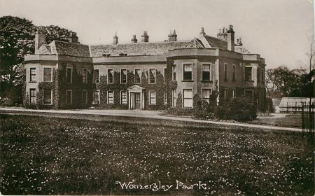
‘The hall is of Magnesian limestone, mainly rendered, with ashlar and brick dressings and with Welsh slate roof. It is U-shaped in plan, with the opening of the U as the main entrance to the south. Alterations were probably made in the mid- 18th century by James Paine and in the late 18th century by Robert Adam’ (NHLE: 1316344, no primary source cited). Further alterations, mostly to the interior, were made in the 19th century. Alterations from the original building included adding a wing to the north so that the house abuts coach house and stables.
Coach House and Stables (NHLE: 1316344; Grade II*)
The Coach house and stables adjoin the extended house to the north west. The date of their construction is not clear but they appear on the 1805 enclosure map, with a small walled area between them and the house at that time.
Gardener’s house
At the north west corner of the productive walled garden and external to the original walled garden. The house has an entrance onto the street with the wall of the yard running parallel to the wall of the walled garden. The 1930 sale plan described it thus: ‘At one corner of the Garden is the Gardener’s Cottage, brick-built and slated and containing: Sitting Room; Kitchen; Scullery with sink; Pantry; Coal House; Fruit Room; Two Bedrooms and Box Room; with Yard and Fowl Run.’ (BIHR WOM/1/1/7/2)
Icehouse (NHLE: 1017824)
The remains of the Victorian icehouse are located in Icehouse Park, 590m to the west of the house. ‘This is a mainly subterranean brick built structure covered by a low mound of earth about 5m in diameter, sheltered by parkland trees The source for the icehouse was Womersley Beck, with a straight well-graded trackway running obliquely downhill north easterly from the icehouse to the beck.’ (NHLE: 1017824). The NHLE listing indicates that the parkland and icehouse were laid out in 1867, although no source for this date is cited.
Gardens and pleasure gardens
The south-facing house has walled gardens to the north-east, with pleasure grounds to the east and immediate south. A belt of woodland links the east entrance to the south front of the house and continues westwards to the south of the church (Fig 5).
The 1930 sale plan (BIHR WOM/1/1/7/2) described the gardens:
The grounds are inexpensive to maintain but include features affording a full measure of delight and usefulness. On the south front beyond the drive is the Park with its ha-ha fence and ornamental plantations; to the west a winding walk through the Shrubbery and Woodland Belt with splendidly grown Beech, Chestnut, Sycamore, Lime, Yew and Cedar trees leads to a private gate giving access to the very interesting and picturesque 12th century church of St Martin’s, a fine monument of past ages. To the East is a gently sloping Lawn, adorned with graceful Beech and Weeping Elm trees and a Rose Walk and Pergola and formal Flower Garden walled on three sides with Shrubbery beyond. Across the drive on the south east is a Tennis Lawn.
The pleasure grounds, ha-ha and walks still exist. The area that was a tennis lawn in 1930, originally developed as pleasure ground between 1850 and 1893, is grassed and surrounded by trees (Fig 5).
Walled gardens
The walled gardens, situated immediately north-east of the house, were part pleasure grounds and part productive garden. They are divided by an internal wall which was constructed earlier than 1805 (present on the enclosure map WYA WRRD B 23). The gardens are walled on three sides - east, north and west as the land rises slightly to the south to trees and lawn. As the three (original?) 18th century wall appear extant, with no sign of a southern wall, it may be that the original walled garden was three-sided with an embankment to the south.
At their greatest extent, from before 1805 until the 1980s, the walled gardens occupied (0.87 hectares, 2.15 acres).
Closest to the house is the smaller walled garden of 0.16 hectares (0.4 acres), containing a hedged parterre and a glasshouse against part of the north wall. This is the area where Lady Anne Rosse had a box-hedge parterre laid out in the 1940’s - now restored. This area is also the formal flower garden described in the 1930 sale plan. It is unclear at what point the walled gardens were subdivided to form a smaller pleasure garden, and a larger productive garden but it was certainly earlier than 1805, and possibly as early as 1707.
Walled gardens were originally developed by Tobiah Harvey. On 24 November 1705, the earliest record of the garden, he noted ‘Sun goes off the south wall in my garden at half an hour after two in the afternoon, continues to shine on the south wall in the garth at Greenwoods.’ (BIHR WOM 2/4/1) On 8 December 1705 Tobiah Harvey planted 12 peaches and nectarines ‘south wall from the church to the orchard’; 1 pear and 5 apricots ‘west wall from Hall Orchard to the house’; an apricot from Doncaster and a vine from Lord Donne’s ‘east wall next dayrys’ (BIHR WOM 2/4/1). The assumption is that by ‘south wall’, Tobiah Harvey meant south-facing wall. In February 1706, 12 different pear trees and 12 different apple trees were planted ‘from the wall to the street’. These plantings imply a walled garden being developed to the north and east of the house, probably in the same location as the current walled garden. It is not easy to reconcile the description of the plantings with the current location of the walls. (Hall Orchard occupied 8 acres to the north of Park Lane and, along with other land, was tenanted by Mrs Greenwood.) Tobiah Harvey noted the progress of this early planting in 1706 ‘25 Feb Apricocks beginning to blossom, peaches with leaves, nectarines to swell, gooseberries and roses with honeysuckles with many leaves, elder with leaves. Pears, dwarfs, walls to swell. Cherrys likewise’; ‘16 Mar pears with leaves & blossoms, nectarines peaches and apricocks with leaves and fully blown’; ‘22 Mar young apricocks, young peaches, cherrys in full blossom, sparagras cryed about street’ (BIHR WOM 2/4/1).
Over the next few years much more fruit is added to the garden:
- November 1706 - 10 peaches, 4 nectarines, 11 pears, 6 plums from Mr Smith of Brompton Park; December 1706 – ‘Noah Perfect for a red nutmeg peach early and large apricock, 9 pears, 10 cherrys wall, 8 cherrys standard; Two plumbs; 4 quinces’.
- In early 1707 distinct parts of the garden appear - a low garden, a best garden and a cloaths garden, implying further compartmentalisation of the walled garden: ‘1 royal bergamot pear 1 La chaser both planted to the south wall of low garden; 1 petit blanquet east wall cloaths garden; 1 bleu pedrigon east wall best garden; 1 bleu pedrigon wall low garden; 1 violet plum 1 queen mother 1 winter bergamot west wall best garden.’
- October 1707: ‘3 apple trees, 7 pear trees wall, 4 wall plumbs, 7 wall & standard cherrys, 2 large green gooseberrys’
- January 1708: ‘standard cherry, Bury de Roy, winter boncrittien Katherine plum’
- November 1709: ‘a royal bergamot, winter bergamot, great rousselet & Gross Blanquet wall pear. Burdine admirable peaches, le royal plumb, two standard musle plumbs, dwarf duke cherry’
- February 1712: ‘1 peach tree, 5 apricots, 11 standard cherrys, two wall plumbs’
- January 1713: ‘a Leroyal plumb, standard warden pear’
- November 1713: ‘2 Flanders cherries’
- January 1720: ‘4 turkey apricocks orange colour’
The vegetable garden was also developed in the early 18th century. A typical annual purchase of seeds (1709) shows the variety sown:
5 oz onyon seed, 1 qt kidney beans, orange carrots ¼ lb, Parsnips, turnips 1 pt, White cabbage lettuce, Sellary 1 oz, purslane ¼ oz, Best cabbage seed 1 oz, cowcumber 1oz, Spinage ¼ lb, Cyprus collyflowers ½ oz, 1 lb shallots, 1 lb radish seeds, 2 ozs Silesia lettuce, 1 oz dutch savoy seed, ½ oz sweet marjoram, 12 tuberose roots, 24 sorts of flower seeds
(BIHR WOM 2/4/1)
By 1788 a land survey valuation shows total area of house, stable and 2 garths of 1 acre (WOM/1/1/1/3). The 1805 enclosure map shows two walled gardens totalling 2.15 acres (WYA WRRD B 23). This suggests the larger, productive walled garden was extended between 1788 and 1805. It is likely than the gates opening onto the productive garden through the east wall (4.6.3. NHLE 1174568) were also constructed at this time.
It is surmised that the productive garden was well tended during the 19th century as named gardeners lived in the village and in the gardener’s house, constructed before 1861 with immediate access to the productive garden.
The 1853 OS map shows a glasshouse (a vinery?) running the length of the north wall in the small garden. There is evidence on the north wall to show the heightening of it to accommodate the glasshouse. The heating arrangements for the glasshouse were housed in a yard of the gardener’s cottage. It appears that the gardener’s cottage and yard were added outside the original walls of the garden. The 1853 OS map also shows a small structure in the productive garden, which then contained some fruit trees. By 1892 (25” OS map) a glasshouse and other structures are additionally shown in the productive garden to the south of the garden and not against any walls. The conservatory, greenhouse and vinery, constructed between 1895 and 1900, appear to be replacements for existing structures rather than new features, as structures are shown in identical positions on the 1892 and 1906 edition OS 25” maps (Fig 5).
The 1930 sale plan (BIHR WOM/1/1/7/2) indicates: ‘There is a large and productive Kitchen Garden, an interesting item in which is a famous Mulberry Tree planted by King James II. Here are the following: Vinery in four divisions stocked with Muscat of Alexandria, Black Hambro’, Madresfield Court and other vines, and with stoke-hole behind; Double Melon and Greenhouse with stoke hole; 15-light heated forcing Pit; Peach house in two divisions; Frame Yard; Bothy or Store; Tool shed; Potting Shed and Office; Mushroom House and Tool Place; and Rubbish and Store Yard with shed.’
If there really was a King James II mulberry tree in the productive garden, then this would suggest that Tobiah Harvey did build a walled garden on the site of an existing garth. More likely, is that the mulberry tree was one ‘descended’ from the original King James (I?) mulberry trees and the date of its planting would be unknown. However, the mulberry tree still exists on the southern edge of the larger walled garden and is known to be very old.
Some small brick and stone buildings still exist on the south western edge of the productive garden. It is likely that these were the sheds and stores referred to in the 1930 sale plan and shown as small buildings on 1853 and 1892 OS maps. A pump is shown near these buildings on the 1892 25” OS maps and remains of a circular stone structure exist.
In the late 1970s the productive garden was used for fruit and herbs by Hon. Martin Parsons in his production of herb jellies and fruit vinegars.
The eastern half of the productive garden (0.9 of the total 0.63 hectares (1.55 acres)) was developed as modern housing in the 1980s (Fig 6). Monitoring of groundworks during this time recorded a stone-built vaulted chamber (NMR excavation index). It is not clear exactly what the purpose of this structure was, although it seems to be shown on the 1906 25” OS map.
Park and plantations
The outline on the Dickinson 1750 map appears to show parkland boundaries which are similar to the walls and belt plantation which constitute the edge of the historic estate. The evidence discussed above suggests that early parkland with lake and some belt plantation was laid out during the latter half of the 18th century. There was, however, significant development in Victorian times – by 1848 a ‘new park’ was shown with a carriageway from the north western edge of the estate through the parkland to the south of the house (Fig 3). Between 1848 and 1893 there were a number of additions: Pontefract Gate Lodge was built; an icehouse was constructed in the north western part of the parkland (icehouse park); the ha-ha was developed in front of the house and along the old field boundary up to the Rookery Plantation; a small area of pleasure ground added to the south east of the house; and a new plantation (Lady Hawke Wood) added to rising ground to the south of the house (Fig 4).
The parkland laid out in Victorian times formed the north eastern third of the whole estate of farmland and parkland. The Victorian parkland has now been broken up into separate parts, under different ownerships. Some of the original pasture parkland, in the north and south parts, away from the house, is now cultivated.
Parkland
At its greatest extent, as evidenced by the detailed survey in the 1930 sale plan (BIHR WOM/1/1/7/2), the total Victorian parkland occupied 44.9 hectares (111 acres) excluding the main plantations. Some of the area closest to the House may have been laid out as parkland in the 18th century as elms and limes were purchased by Tobiah Harvey between 1710 and 1720.
The Victorian parkland appeared to respect the existing field boundaries, as the field boundaries shown on the 1805 enclosure map of the estate and on the OS maps are still in existence today, including those which cross the parkland. This compartmentalisation by field boundaries showed the 1930 sale plan dividing the parkland among 5 lots (north to south):
- the northern fringe of the Ice-house park (5.58 hectares, 13.79 acres) formed part of the lot of Manor House Farm;
- the main part of the northern ice-house park (14.14 hectares, 34.95 acres), along with part of the Rookery plantation (1.37 hectares, 3.38 acres) formed part of the lot of Park Farm;
- the middle parkland including the tennis lawn (0.2 hectares, (0.49 acres))(11.9 hectares, 29.41 acres in total), Lady Hawke Wood (0.48 hectares, 1.13 acres) and part of the Rookery plantation (1.7 hectares, 4.20 acres) formed the parkland associated with the house – this is the remaining parkland of Womersley Park in ownership with the house and gardens;
- a ‘field’ of parkland (5.6 hectares, 13.85 acres) to the south east of the middle parkland formed a lot of pasture land;
- a ‘field’ of parkland (7.65 hectares, 18.90 acres) to the south west of the middle parkland formed part of a lot of pasture and arable land.
Only the middle parkland (indicated above) is the remaining current parkland. Within this parkland are examples of notable and veteran trees including false acacia, cedar of Lebanon, beech, walnut, turkey oak and weeping beech.
The parkland of the icehouse park is currently pasture and protects the scheduled medieval settlement and icehouse. The rest of the parkland is under arable cultivation.
Water features
Although there are no current features containing water, apart from the natural streams on or near the boundaries, a lake is shown on the 1805 enclosure map. The lake ran parallel to Womersley Beck (Fig 2) and, on the evidence of Stukeley’s diary, was possibly constructed before 1750. The lake is not shown as a water feature on any maps later than 1805. However, its outline shows on RAF aerial photographs (Monument number 1430325) and is just about discernable on current satellite maps. The lake was about 220m long by about 14m wide, with an area of about 0.26 hectare (0.64 acre). The lake may have been constructed as part of early parkland under William or Stanhope Harvey’s ownership to reflect the fashion in the mid to late 18th century for sweeping parkland with lake.
Fishponds were created between 1805 and 1850 to the north of Park Lane in part of an area named in 1805 as Hall Orchard. A fishpond of 0.166 acre (0.067 hectare) was listed in the 1930 sale plan and remains as a dried up feature in the summer of 2016.
Plantations
A belt plantation, of mixed woodland, surrounds the whole estate of (357 acres), except where a short stretch, adjoining the stream on the south western boundary, has been removed. The belt plantation averages about 35 metres (115 ft) across. A driveway, from the eastern gated entrance, runs through part of the eastern belt. The 1805 enclosure map, the earliest available map evidence, shows the existence of belt plantation from the edge of the western oak wood plantation around the northern half of the estate to the point that becomes the southern-most point of the parkland. By 1848, the belt plantation had been extended to include the southern half of the estate.
Rookery Plantation (3.07 hectares, 7.58 acres) is on the rise at the highest point of the estate. This deciduous woodland was in existence prior to 1805 (1805 enclosure map), although a narrow strip descending towards the northern boundary was lost between 1805 and 1848.
Lady Hawke Wood (0.46 hectares, 1.13 acres) is on the southern edge of the middle parkland associated with the house. It was planted between 1848 and 1892 (OS maps).
Oak Plantation (5.0 hectares,12.37 acres) is on the western edge of the whole estate. It existed prior to main developments of the parkland and was retained.
Books and articles
- Hind, C.A., 2005. Ancient Womersley and her people. Harris Bros, West Yorkshire
- Pevsner, N. & Radcliffe, E., 1967. The Buildings of England: Yorkshire: The West Riding. Harmondsworth, Penguin
- Surtees Society, 1887. The Family memoirs of the Rev William Stukeley, volume III. Page(s) 363-4. Publications of the Surtees Society: Ripon, William Harrison
Primary sources
Borthwick Institute. University of York (BIHR) - Womersley collection
- WOM/1/1/1/1 'A particular account of all the lands and tenants belonging unto Tobiah Harvey Esq. in the Lordship of Womersley'. May 1700
- WOM/2/4/1 Personal and Estate Accounts of unknown author May 1705-July 1720. (although this is catalogued as by an unknown author, detailed study of the entries show the author as Tobiah Harvey)
- WOM/1/1/1/3 Land Survey Book - Survey of rental value of land, gives acreage of land and assessment of rateable value. Drainage accounts at rear 1788
- WOM/1/1/7/2 Particulars, plans, views and conditions of sale of Womersley Estate, for sale Wednesday and Thursday 30/31st July 1930 1930
- 15
- WOM/1/1/3/1 Womersley Estate Cash Accounts Also includes Estate Accounts for building work, Hall Wages, Sundry Items, Gardens, Game, Drainage, Charities and summary of Lady Rosse's private account. December 1893-January 1900
- WOM/1/1/3/2 Womersley Estate Cash Accounts February 1900 - April 1909
- WOM/1/1/3/3 Womersley Estate Cash Accounts May 1909 - October 1919
Buckinghamshire archives
- D/X 1069/1/2, the diary of John Baker of Cornhill, linen draper, while travelling from Tring, Hertfordshire, to Nottinghamshire and Yorkshire, 25 May - 13 July 1728.
- Doncaster Parks and Gardens Report on Campsmount Park - Doncaster Local Development Framework Identification and Assessment of Parks and Gardens of Local Historic Interest Report 2013. Appendix VII pages 18-22.
http://www.doncaster.gov.uk/services/planning/local-parks-and-gardens (accessed 7/9/16)
West Yorkshire Archives (WYA)
- WYA WRRD B 23 - Womersley enclosure map WRRD B 23: A map of the township of Womersley in the West Riding of the County of York. Drawn by Robert Lamb for the inclosure thereof, 1805
Maps
- Ordnance Survey 1st edition, 1: 10,560 Surveyed 1848, Published 1853
- Ordnance Survey 2nd edition, 1: 2,500 surveyed 1890, revised in 1904, published 1908
- Ordnance Survey one inch, Revised 1894, Published 1896, Sheet 78 (Outline)
Figure 1 - Location of Womersley Park. Map base contains OS data © Crown copyright and database right 2016
Figure 2 - Northern part of Womersley estate from 1805 enclosure map
Figure 3 - Annotated map of Womersley Park - Ordnance Survey 1st edition, 1: 10,560 Surveyed 1848, Published 1853. Reproduced by permission of the National Library of Scotland
Figure 4 - Womersley Park landscape in late 19th century. Ordnance Survey one inch, Revised 1894, Published 1896, Sheet 78 (Outline). Reproduced by permission of the National Library Scotland.
Figure 5 - House, gardens and immediate parkland 1893
Figure 6 - House, gardens and immediate parkland in 2016


