North York Moors National Park
Woodlands was the house and estate of the Yeoman family for over 200 years. Henry Walker Yeoman I began to develop the estate and laid out a picturesque landscape from 1795, possibly under the guidance of his head gardener Alexander Willison. After his death in 1800 and for the remainder of the century, the estate was mainly tenanted and the landscape was little altered.
In 1901, five spinster sisters of the Yeoman family inherited the Woodlands estate. Under their ownership the grounds were further developed and the garden was opened to the public regularly for charitable purposes. Between 1919 and 1921 the sisters had the house remodelled by the well-known York architect Walter Brierley, who had collaborated with Gertrude Jekyll in his own and other gardens. He may therefore have used that experience to influence the sisters with Jekyll’s style of gardening such as the extensive herbaceous borders.
After 1939, large parts of the wider estate were sold and following the death of Charlotte Yeoman in 1958, the remainder of the estate was sold off in 12 lots. The mansion house and adjacent land became a boarding school. The pleasure grounds were altered to provide a tennis court and croquet lawn for the pupils. One of the 12 sale lots, which included the coachhouse and ‘Cockpit’, was sold to Lady Armatrude de Grimston. She built a residence on this land and developed gardens on the slope below the Cockpit.
In 1988 the school closed and became a nursing home under new ownership but was later converted into 14 private apartments. The part of the estate that had belonged to Lady de Grimston was bequeathed by her to the Order of the Holy Paraclete and became St. Oswald’s Pastoral Centre.
Estate owners
James Yeoman (d 1751) from Whitby, bought a property in 1726, formerly in the possession of Richard Woodhouse, which is recorded as Woodhouse’s house and croft. James Yeoman’s son, John, bought land in Eskdale and in 1773 purchased Newbiggin Hall, an ancient house about one mile to the west of Woodlands. John Yeoman died in 1782, bequeathing Newbiggin Hall to his wife. His will makes no direct reference to Woodlands but concludes with ‘All the rest and residue of my said real estate not otherwise disposed of to my said son Henry Walker Yeoman’ (Will of John Yeoman, BIA Vol.126 f185).
Henry Walker Yeoman I began to develop the Woodlands estate after the death of his father and following his marriage to Anne Hale in 1786. He died in 1800, by which time he had bought considerable property. Henry Walker Yeoman I was succeeded by his 10 year old son, Henry Walker II. During the latter’s minority, the house was let to Mrs Cordelia Withers from c. 1804 to 1813 (Green 1823, 241). In 1816 Henry Walker Yeoman II married his first cousin, Lady Margaret Dundas, and they initially lived at Marske Hall, Cleveland. About 1821, the family moved to Woodlands. He continued to add to the Woodlands estate by acquiring the properties of Groves Mill and Hall in 1821 (NYCRO ZRY 1/1/16 & 17). Henry Walker Yeoman II lived at Woodlands until 1835, when the house was put up for either sale by private contract or to be let for a term of years (Yorkshire Gazette, 8 August).
The estate however remained his property and was managed by the land agent, Henry Swinton Walker and then his son George Dundas Yeoman. In 1875, Henry Walker III (1816-1897) inherited, but lived primarily at Marske Hall, Cleveland. Henry Walker Yeoman III died in 1897 without issue and his five spinster nieces (daughters of his brother, Constantine) inherited Woodlands.
Miss Charlotte Yeoman, the last remaining sister, died in 1958 and her niece, Margaret Winsome Wharton, inherited the estate. Margaret’s husband, Christopher Hildyard Ringrose-Wharton, acting on behalf of Broadland Properties Ltd, sold the estate in 1960 (NYCRO 1465/974/458). The estate was divided into 12 lots to enable the sale to be managed (Figure 1). One of the lots, the house and its immediate grounds, was bought by the Order of the Holy Paraclete and became a boarding school. The house remained in this use until 1987, when it closed (Barker 2001, 57) and was put up for sale.
In 1988 Woodlands house and immediate surrounding land was bought by the Benet Partnership and became a nursing home. In 1999, the owners, Esk Investments Ltd, converted Woodlands into private residential apartments. In 2002 the freehold was transferred to Woodlands Management (Sleights) Limited.
The original working part of the estate, including the coachhouse (known as the Castle) and ‘Cockpit’, was bought in 1960 by Lady Armatrude Waechter de Grimston (NYCRO 1487/57/27). She died in 1982 and bequeathed her property to the Order of the Holy Paraclete. In 1983, the buildings and land were opened as St. Oswald’s Pastoral Centre (Barker 2001, 57).
Key owners responsible for major developments of the designed landscape and dates of their involvement:
Henry Walker Yeoman I (1782 – 1800)
Henry Walker Yeoman II (1821 – 1835)
Margaret Constance, Sophia, Eva, Charlotte and Mary Yeoman (1901 – 1958)
Lady Armatrude Waechter de Grimston (1960 – 1982)
Early history of the site
At the time of the Domesday survey in 1086, Aislaby was mainly wooded (1 square league, c. 9 sq. miles). There is the possibility that this was emparked as William de Rosels in 1279–81 stated that his title to park and warren in Aislaby went back to the Conquest (VCH 1923). Some indicative names survive for example ‘Park Hill Close’ and ‘Old Park’ in the deeds (NYCRO ZRY 1/1/11 & 24). A building on the site of Woodlands Hall is said to date from 1470 (VCH 1923). This building may have been a farmstead or croft.
The Cholmely family had bought the Whitby Abbey lands, including Aislaby, after the latter’s dissolution (1536-45). In 1633 Sir Hugh Cholmely acquired the manor of Aislaby. His brother, Sir Henry, sold the land that would become the Woodlands estate in 1661 to Robert Fotherley. The dwelling on this land was known as Woodhouse’s House and croft and had been lived in by Richard Woodhouse. On the 1645 Blaeu map of Yorkshire, the area is shown as largely wooded, so this may be the source of the name of the site.
The estate that James Yeoman bought in 1723 comprised the following (NYCRO ZRY 1/1/1):
Woodhouses House and croft, and lands called the Doopes, the Reddings, the Ashead, the Imking, a piece of the common, the High Round Close, Low Ground Close, and Two Little Wheate Closes, Leasam, and the Broad Ing.
The land amounted to 29¾ acres.
Chronological history of the designed landscape
c.1790 – 1850
Henry Walker Yeoman inherited the estate from his father in 1782 but only appeared to start developing the estate after 1790. In 1792, he acquired further land in the township of Aislaby (NYCRO ZRY 1/1/9, 10 & 12) and two years later bought the following, that formed part of the designed landscape:
‘A piece of wood called Oak Hill, a piece of meadow or pasture (part of a close called Barley Field), a piece of wood extending from the above pasture down a steep precipice to the River Esk formerly belonging to William Elgie’ (NYCRO ZRY 1/1/10)
No plans of the designed landscape relating to this period have been found but Henry Walker Yeoman I employed a gardener, Alexander Willison, from c. 1794. A painting by Amos Green that can be dated to 1804 (Green 1823, 241), shows Oak Hill and its footpaths, as seen from Woodlands (Figure 2). An early sketch by a member of the family, also presents a view of Woodlands from Oak Hill (Figure 3). The two illustrations provide some evidence that the pleasure grounds were developed in the fashionable ‘picturesque’ style. The setting of Woodlands, with its stream, adjacent river and panoramic views appears to have been well suited to this style.
Development of the area adjacent to Oak Hill included the creation of two cascades built into the stream as it flowed to the Esk. The two cascades enhanced the approach to the natural gorge through which the stream dropped steeply towards the Esk. The cascades and gorge combined to create a dramatic surprise view whilst walking the footpaths around Oak Hill. The River Esk, to the south of the property, contributed to this picturesque scene. A sale advertisement gave the following description of the landscape: ‘the banks of which [the Esk] are adorned with luxuriant hanging woods and picturesque rocks’ (Yorkshire Gazette, August 1835). The 1844 tithe map (Figure 4) shows the designed landscape with pleasure grounds around the mansion (No 130) of 1¼ acres, garden of just under an acre (No 129, possibly a walled kitchen garden), an orchard of just over ½ acre (No 128) and surrounding plantations of just under 18 acres.
After Henry Walker Yeoman I’s death in 1800 the house was let to tenants. Alexander Willison, the gardener, continued to live on the Woodlands estate, although he was now developing his market garden business in Whitby. By the early 1820s Henry Walker Yeoman II was resident at Woodlands and developing the property, including building the coachhouse and ‘Cockpit’. He extended the estate by buying more land in Aislaby, specifically Groves Hall, in 1821:
A house called Groves Hall and closes called the Horse Pasture, the High Field, the Banks, and the Barley Field, parcels of wood, and the lane from Sleights Bridge through the above land, a water corn mill, and skinning mill ½ ac. land in Eskdaleside (NYCRO ZRY 1/1/17)
However the property was put up for sale or rent in 1835 and as a buyer was not found, advertised for rent again in 1843 (Yorkshire Gazette, 8 July). It was described as ‘commanding diversified and picturesque scenery, not to be surpassed in the north of England’ (Yorkshire Gazette, 8 August 1835). At this stage, the kitchen garden, which was possibly walled, was located in the low-lying ground next to the stream. The 1844 tithe map (Figure 4) shows distinct lines running due south and there is a building depicted in the northwest corner. The area labelled the orchard is also possibly walled on three sides. All the walls in the two garden areas seem to have disappeared by the 1st edition OS, surveyed in 1849 (Figure 5), however the kitchen garden has been landscaped with paths now around it.
1851 – 1921
Despite being a secondary property for the family, further limited work was done on the estate. In 1860, the lodge gatehouse to Woodlands was built at Briggswath. It was at the start of the drive leading to Woodlands. Following Henry Walker Yeoman II’s death in 1875 his son, also Henry Walker, succeeded but lived at Marske Hall and Richmond. Woodlands was let to various tenants, although the Hall was completely re-modelled by the addition of two principal rooms on the south elevation, plus a drawing room and a dining room, with two bedrooms above. In 1904, the old wing was pulled down and rebuilt (VCH 1923).
The Yeoman sisters, on inheriting the property in 1901, made significant changes to the grounds. New glasshouses were constructed in the pleasure grounds to the east of house with a raised area to the south (Figure 6). Herbaceous borders were developed to the south running down towards the ha-ha and rose beds were planted, with old stone gateposts later used as support for climbing varieties (Figure 7). In 1919, they commissioned alterations to the building from William Brierley of York. The house was totally re-modelled with the two wings extended, incorporating new staff quarters. The estimated cost in 1919 by Brierley was £6,000 - £7,000, however the completed cost in 1921 was £24,807 18s 9d (BIA ATKB).
Later history
The Yeoman sisters continued to develop the grounds and by 1928, they had increased the size of glasshouse with the garden area (marked 5a) reduced in size and replanted (Figure 8). Photographs from the 1950s show the garden prior to its sale (Figures 9 and 10). Following the sale in 1961, over 7,000 trees were planted on Oak Hill and surrounding land, to replace the trees that were felled for timber after 1939 (HO).
Lady Armatrude de Grimston, following her purchase in 1960, planted trees and shrubberies on sloping land around the Cockpit (Figure 11), accessed by a wide path round the hill at the top of the slope.
Location
Woodlands is situated in the parish of Aislaby. The house is located in the valley south of Aislaby village, on the north bank of the River Esk. The house is less than 4 miles from the mouth of the River Esk at Whitby.
Area
The historic designed landscape is about 50 acres.
Boundaries
The property is bounded by the River Esk to the south as far as the lodge at Briggwath to the east. The northern boundary then runs westwards from the Lodge past Groves Mill to the Hall. The eastern boundary follows the woodland north to Aislaby village, with the western boundary running parallel to this back to the stables.
Landform
The Esk valley here runs from west to east and is roughly 2 miles wide. The moors above reach some 200 metres OD while the river below Woodlands flows at about 10 metres OD.
The solid geology of this area consists of beds of the Upper Lias in the valley, topped by Deltaic Sandstones of the Jurassic period on the moors above. Some of the latter, notably those above Aislaby on the northern flank, are high quality building stone. Other minerals are found, including alum rock, on the upper reaches of the southern slopes.
The profile of the valley owes much to the effects of glaciation. An extensive lake formed here towards the end of the Ice Age, resulting in wide deposits of glaciofluvial tills. Water escaped from the lake through a gorge that starts a little below Woodlands and is now the course of the River Esk.
There are few areas of level land in the valley and gradients vary from gentle to steep – up to i:4. These gradients lead to the terracing in Woodlands’ garden and the opportunity to create a picturesque landscape. Agriculture is mainly arable and grass with woodland, some long established on less accessible sites.
Villages along the Esk valley are usually reached from roads leading off main arteries across the moor. In this area there is one minor road along the upper slopes on each side of the valley that gives access to the farms.
The river favours the northern side of the valley here, as it does through much of its course, with the result that streams from the northern heights tend to take a direct route with considerable force. There have been some problems of erosion. For example, part of the drive to Woodlands has been reinforced and further up the drive, where it passes above a deep-cut stream, substantial reinforcement of the banks has been needed. Below Woodlands itself, where the Esk takes a series of sharp bends, the river has undercut the bank so as to create a steep drop in places.
Setting
The drive leading to the house from the A169 is bordered on its northern side by plantations of beech and larch on rising ground, bounded on the side of the drive by a wall of hand-tooled local stone. To the south side of the drive an iron fence guards a similar plantation. The ground falls away sharply to the south, leading to the beck that tumbles through a series of waterfalls overhung with ferns.
From the gardens, to the south of the house, there is an attractive view across the Esk valley to Eskdaleside and Sleights. An article from the Yorkshire Gazette, dated 24th August 1846, describes the setting of Woodlands as ‘so magnificently wild and beautiful that even the scenery of romance might fear to compete with it’.
Entrances and approaches
Woodlands Lodge built in 1860, is in Briggswath village and was the gatehouse to Woodlands. The remains of one of the original gateposts can be seen in the wall that bounds the garden of Woodlands Lodge. The original carriageway, which predates the Lodge, began at this point. Prior to the Lodge being built, coaches travelling to and from York would stop at this point from 1788, as there was a toll house by the bridge (Young 1817, 579). In 1930 the medieval bridge at Briggswath that carried the road over the River Esk, was washed away in a major flood. A new road was constructed, slightly to the west of the original route, and was opened in 1937. This is the current route of the A169 from Pickering to Whitby. Following the opening of the new A169, Woodlands Lodge was effectively separated from the main house. Woodlands is now approached via a long tarmacadam drive off the A169 near Briggswath.
A second approach to Woodlands was from the north, along a bridleway, from the village of Aislaby. A third approach was along the old carriageway, through the estate from the ford near Eskdale chapel, up towards Galley Hill, for use of which the Lords of the Manor of Mulgrave paid annual rent of one deer to the Woodlands estate (Whitby Naturalists Report, April 2nd 1939). The fording of the river at this point is shown clearly on a plan from the Field Book of 1822 (SCA).
Principal buildings
Mansion House [Grade II, NHLE 1148951]
The mansion house has undergone many changes since its original construction:
The building is a double-pile house, built to a less formal and regular plan. This may represent a ‘picturesque’ approach in a rather mild form, for the house has also a crowning battlemented parapet, but it may also be a response to the site. On a sloping site such as this, the most desirable orientation is for the house to face down the slope towards the view, but this makes it difficult to have a reasonably spacious approach to the front door. At Woodlands a pragmatic approach to this problem has produced a formal five-bay elevation facing south, with the main entrance on the west, where there was no attempt at symmetry (Houses of the North York Moors, 1987, HMSO).
The sale particulars of 1835 state:
the house contains an entrance hall, dining room and drawing room, each 25 feet by 18 feet, library 18 feet square, capital kitchen, back kitchen, housekeepers room, water closet and other domestic conveniences on the ground floor, eight lodging rooms, two dressing rooms and water closet on the first floor and seven lodging rooms above servants hall, bathroom, butler’s pantry, wine and ale cellars in the basement and connected with the house is a new built laundry, three lodging rooms for servants, a brick oven and a water closet’ (Yorkshire Gazette, 26th September 1835).
The house was considerably altered in the period 1919-1921, when Walter Brierley was commissioned to undertake major alterations. With the purchase of Woodlands by the OHP in 1960, to serve as a school, a programme of major architectural refurbishment was implemented over a number of years. A chapel was created in the basement in what had been the wine cellar. A common room was built, and a gymnasium. The upper rooms were divided to create the required number of dormitory and staff bedrooms. In 1987 the sale of Woodlands resulted in the property becoming a nursing home, again, an extensive programme of conversion was undertaken. The nursing home closed in 1998. By 2001 the house had been converted to 14 luxury apartments.
Groves Hall and Mill [Grade II, NHLE 1316082]
Purchased in 1821 (NYCRO ZRY1/16&17) together with 4 acres of wood, 7 acres of land, garden and orchards. Sold in 1960 as a separate property (NYCRO 1444/813/376)
Coachhouse/Stables [Grade II, NHLE 1316084]
The 1835 sale advertisement included reference to the coachhouse having capacity for 3 carriages and stabling for 14 horses. Today the reconfigured building forms part of St Oswald’s pastoral centre and comprises 3 residences. The façade has castellations similar to those on the Mansion House.
Icehouse
The icehouse is located in the grounds of the estate, to the north west of the main house at NZ 860 080 and is thought to date from the 18th century. The icehouse was partly submerged below the ground for insulation purposes; it is constructed of stone blocks and has a tunnel-vaulted roof.
Brew House
The brew house was located on flat land immediately to the north of the drive (NNE of the main house), adjacent to the stream, NZ 861080. Now demolished, the site was referenced in the Whitby Naturalists Report of 1939, the map evidence suggesting the buildings were removed by 1911 (Figure 8).
Glasshouses
Built between 1892 and 1911 on a site due east of the main house, NZ 861080. The building was expanded in 1928. The site of the glasshouse is now occupied by garaging for the residential apartments of the main house.
Cockpit [NZ 080850]
The Cockpit (referred to as ‘poultry house’ in the 1835 sale catalogue and ‘kennel’ on the OS 6” first edition map - surveyed 1849, published 1853) is situated on land that is now part of St. Oswald’s Pastoral Centre. This building is not listed. It is situated on the south facing valley side, quite a distance, north west of the mansion house. The Cockpit is constructed of tooled stone, similar to the mansion house, coach house and stable block. Flues from two external fireplaces heated the back wall of the cockpit. Today, the Cockpit is a place for quiet contemplation, used by the nuns and their visitors. There is a splendid view of the Esk valley from the cockpit (Figure 12).
Bridges
There is a carriageway bridge, located immediately to the north of the main house at NZ 861 080. Two ornamental stone bridges cross the stream, downstream of the carriageway bridge located at NZ 86240 08061 and NZ 86269 08057.
Cascades
Northern cascade is immediately below the carriageway bridge and southern one is at NZ 863080. Made of stone blocks.
Sundial [Grade II, NHLE 1148952]
Located 8 metres south of the main house. Believed to date from the 18th Century and first shown on 1892 25” OS map (Figure 12)
Ha-ha
A stone wall now divides the pleasure grounds from the park. A photograph from 1870 shows a hedge and a fence where the ha-ha is now, indicating the ha-ha was a later addition (Figure 13).
Wells
1st Well, marked on the 6” 1st Edition OS map (Figure 5) just south of the western end of the ha-ha. No visible evidence above ground. 2nd Well, with remains of hand pump, with name OMBLER, dated 1880, marked ‘W’ on 25” 1st Edition OS map (Figure 12), just north of the Cockpit.
Gardens and pleasure grounds
Alexander Willison, a Scot, was employed as gardener from around 1794 to 1812, although there is no further information on the pleasure grounds developed at that time. From 1900 the gardens were opened regularly, in support of various charities, throughout the six decades that Charlotte Yeoman lived at Woodlands. Initially, the roses and rhododendrons were highlighted as being worthy to view (Figure 10). In 1913 there was a report in Whitby Gazette relating to Alfred Gaunt FRHS, giving a lecture in the garden, to interested company, including visitors from a wide area. The company were conducted through the gardens and received an object lesson on propagating carnations. Instruction was given on the removal of rhododendron flowers to assist the plant continuing to flower in profusion. The greenhouses and kitchen garden were also visited, where the frequent error of digging celery trenches too deep was brought to the attention of the visitors. The rock garden was visited and, in calling attention to the profusion of plants, notice was drawn to the use of saxifrage as a useful plant for this location.
Post 1921, after work on the house by Brierley, herbaceous borders were developed to the south of the house, extending to the ha-ha. Brierley had collaborated with Gertrude Jekyll on other gardens and may have influenced Miss Yeoman with Jekyll’s style, as old photographs from this period show herbaceous borders with drifts of perennials (Figure 9). Roses were also in abundance in the garden, with old stone gate posts being an unusual feature for the support of climbing varieties (Figure 7) (Whitby Naturalists Report, 1939, and photographs from Whitby Museum). Today, the formal gardens comprise terraced lawns with stone steps descending past shrubs. The old stone gateposts can still be seen in the garden, though they no longer support roses. There is a tennis court, remaining from the time the house being a boarding school.
Kitchen garden
The tithe map of 1844 (Figure 4) shows an area marked as ‘garden’ (probably a kitchen garden) to the southwest of the stream. Three distinct lines, running south across this area, are marked on the map. An orchard, just over half an acre, is marked on the opposite side, north east of the stream; this partly extends on to Oak Hill. On the 6 inch, first edition, OS map (Figure 5), surveyed in 1849, the orchard is no longer evident on the northeast side of the stream. The site of the kitchen garden remains to this day unchanged in size. The site visit revealed a relatively neglected area. A row of old apple trees, and a row of box hedging, can still be seen in the same area as indicated on the Tithe map (Figure 4). The site of the kitchen garden is relatively low lying and, during the site visit, was found to be very wet underfoot despite it being a dry summer. Later sale catalogues, and contemporary comments, refer to this as ‘the orchard’. It may be that vegetable gardening on any scale was abandoned here at an early date due to the ground conditions.
Park and plantations
Parkland
To the south of the Hall, this is first shown on the tithe map and described in the award as ‘Green Meadow’ (just under 8¼ acres) and ‘The Holme’ (2 acres).
Plantations
Oak Hill is possibly the oldest plantation, as it was in existence when Henry Walker Yeoman acquired it in 1792. As no other woodland is specified in the deeds, the remaining plantations, around the parkland and to the north and east of the house, were probably put in after Yeoman’s purchases in the 1790s. The sales advertisement from 1835 states: ‘The oak and ash timber is very valuable, being of great size and beauty, and the Plantations are in a very healthy and thriving condition’ (Yorkshire Gazette, 8th August).
In 1939, large parts of the woodland were cleared and sold off: ‘For auction – about 50 acres of growing timber, mainly larch, fir and spruce, with some hardwoods’ (Yorkshire Post and Leeds Intelligencer, 14th October). Under the new ownership, there was considerable new planting in 1961 with trees supplied by Royal Ask Nurseries, Alnwick (AOHP). The planting included: 5,000 European larch, 1,225 sycamore, 1,200 beech, 4 lime, 6 acer, 3 whitebeam, 15 copper beech, 3 birch, 20 horse chestnut, 12 golden willow, 3 swamp cypress and 3 Lawson cypress. The total cost of these was £166. In 1963, a further 6 acres of woodland was planted at a cost of £300.
William Willison (1806-1875), son of Alexander Willison (gardener at Woodlands, 1795 – 1812), became a noted horticulturalist, nurseryman and botanist. He became nationally important in locating, identifying and naming many British ferns. Many of the ferns that he found and named were from the Woodlands estate (Lowe 1865). It is understood that, in Victorian times, Woodlands contained many important British ferns. It has not been established whether any of these ferns have survived into modern times.
Books and Articles
Barker, R. 2001 Whitby Sisters. Whitby: Order of the Holy Paraclete
Green, H. 1823. Memoir of the late Amos Green Esq. written by his late widow. London and York: Longman et al.
Lowe, E.J. 1865. Our Native Ferns: A History of British Ferns and their Varieties. London, Groombridge and Sons.
RCHM 1987. Houses of the North Yorks Moors. London: HMSO.
VCH 1923. The Victoria History of the County of York North Riding: Volume 2. London, The St. Catherine Press.
Young, G. 1817. A history of Whitby, and Streoneshalh Abbey. Whitby, Clark and Medd.
Primary Sources
Borthwick Institute for Archives (BIA)
Vol.126 f185 Will of John Walker (dated 13.1.1780, proved May 1782)
Vol.144 f66 Will of Henry Walker Yeoman (dated 29.9.1798, proved April 1800)
ATKB Archives of Walter Brierley
The National Archives (TNA)
IR 29/42/6 Tithe award for township of Aislaby, 1843
IR 30/42/6 Tithe map of township of Aislaby, 1844
North Yorkshire County Record Office (NYCRO)
Yeoman family archive ZRY
1/1/1 Aislaby: deeds of property [Woodhouses house & croft] purchased by John Yeoman, 1726
1/1/9 Aislaby: deeds of property [farm and land] purchased by Henry Walker Yeoman, 1792
1/1/10 Aislaby: deeds of property [Oak Hill etc] purchased by Henry Walker Yeoman, 1794
1/1/12 Aislaby: deeds of property [East and West Farm] purchased by Henry Walker Yeoman, 1796
1/1/16 Aislaby: deeds of property [Groves Mill] purchased by Henry Walker Yeoman II, 1821 includes plan
1/1/17 Aislaby and Eskdaleside: deeds of property [Groves Hall] purchased by Henry Walker Yeoman II, 1821
Registry of Deeds
1444/813/376 Sale of Groves Hall and Mill, 1960 [Vol. 1444, p.813, no.376]
1465/974/458 Sale of part of Woodlands estate (Hall and surrounding grounds), 1960 [Vol. 1465, p.974, no.458]
1478//57/27 Sale of part of Woodlands estate (Stables, Cockpit and surrounding land), 1960 [Vol. 1478, p.57, no.27]
K Woodlands Estate sale catalogues, 1959 & 1987
Private Collection
Painting by Amos Green: View from a Window at Woodlands, 1804
Archives of the Order of the Holy Paraclete (AOHP)
Saint Oswald’s Pastoral Centre/ Sneaton Castle
Order for trees from The Royal Ask Nurseries of Alnwick, 1961
Trees planted in 1963
Skelton Castle Archives (SCA)
Early photograph of Woodlands from the 1870s
Sketch of Woodlands by F Hale of Acomb, nd [early 19th century]
Fieldbook of the estate, 1822
Whitby Museum Archives (WMA)
1950s photographs of Woodlands estate
Whitby Naturalist’s Club 1939. Annual Report
Newspapers
Whitby Gazette
Yorkshire Gazette
Yorkshire Post and Leeds Intelligencer
List of Figures
Figure 1 – Woodlands Estate sale map 1959. Source: North Yorkshire County Record Office
Figure 2 - Looking towards Oak Hill, as seen from Woodlands Hall. Painting by Amos Green, 1804 (private collection).
Figure 3 - Family sketch of Woodlands Hall from Oak Hill by F. Hale, early 19th century (Skelton Castle Archives).
Figure 4 – Woodlands Hall and immediate grounds, tithe map of the township of Aislaby, 1844 (The National Archives).
Figure 5 – Woodlands estate, 1st edition 6” OS map, surveyed 1849, published 1853. Reproduced by permission of the National Library of Scotland.
Figure 6 – Photograph of stone pillars with roses, 1950s. By permission of Whitby Literary and Philosophical Society.
Figure 7 – Woodlands estate, 25” OS map, revised 1911, published 1913. Reproduced by permission of the National Library of Scotland.
Figure 8 - Woodlands estate, 25”OS map, revised 1927, published 1928. Reproduced by permission of the National Library of Scotland.
Figure 9 – Photograph of herbaceous borders, 1950s. By permission of Whitby Literary and Philosophical Society.
Figure 10 – Photograph of rhododendrons surrounding the orchard, 1950s. By permission of Whitby Literary and Philosophical Society.
Figure 11 – Photograph of the Cockpit, 1950s. By permission of Whitby Literary and Philosophical Society.
Figure 12 – Woodlands estate, 1st edition 25” OS map, surveyed 1892, published 1894. Reproduced by permission of the National Library of Scotland.
Figure 13 – Photograph showing hedge and fence in location of ha-ha, 1870s (Skelton Castle Archives).
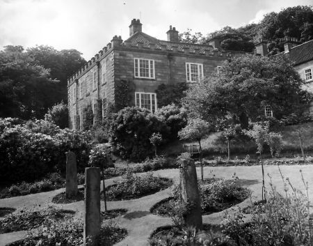
Figure 14 - Photograph showing the Hall in a woodland setting, 1950s. By permission of Whitby Literary and Philosophical Society.


.")
