The grounds of Grimston Garth, although on a small scale, are an excellent, largely unchanged, example of a landscape designed by the prolific late 18th-century landscape gardener Thomas White. The parkland retains his characteristic perimeter plantations, with a break on the east side providing a sea view from the delightful Gothic summer residence.
The grounds are of particular significance as almost the only area of woodland along the Holderness coast from Bridlington to Spurn. It is one of the most important areas of designed parkland in the East Riding not protected by inclusion on the list of Registered Parks and Gardens.
Estate owners
Grimston was held, as part of the manor of Roos, from the mid-12th century by the Grimston family from the Ros family and their heirs. (Kent , VCH Yorks ER, VII, 42.) The manor of Garton with Grimston passed down to Thomas Grimston of Kilnwick-on-the-Wolds in 1780 who built the present Grimston Garth in 1781-6 as a summer residence. (Ingram, Leaves, 104-125.)
The estate descended in the family to Thomas’s grandson Marmaduke Grimston (1826-1879) the last of the male line. It was through his daughter Rose, wife of George Hobart, that it passed to their daughter Armatrude Rose Sophia Effie Bertie, Lady Waechter in 1927. Lady Waechter, who took the additional name de Grimston, gave the estate to her cousin Norman Grimston in 1946, who sold the estate two years later to St Andrew’s Steam Fishing Co. Ltd. In 1949 Grimston Garth (the house) and other land were bought by Joan Little, and she in turn, in 1964, sold the house and part of the grounds to Reckitt & Sons (later Reckitt & Colman). In 1972 the house and some of the grounds were bought by Oliver Marriott. (Kent, VCH Yorks ER, VII, 43.)
Early history of the site
The medieval Grimston Garth or Hall stood some 500 metres north of the present house on a moated site that still survives. The house contained 7 hearths in 1672 when it was occupied by William Grimston (1640-1711). The building is said to have been burnt down during his lifetime. (Kent, VCH Yorks ER, VII, 43.) A farmhouse was built on the site. Just to the west of the hall site is another smaller moated area called The Mount which may have been an ornamental feature in the grounds. It lies in an area known as Great Parks which, it has been suggested, may be the area that was reported in 1517 as having been converted to pasture.
The site of the present Grimston Garth and its parkland lay in the area of open-field land that had been enclosed by the later 17th century. Ridge and furrow survive in the northern and north-eastern part of the park
Chronological history of the designed landscape
Late 18th-early 19th centuryOn inheriting the estate Thomas Grimston decided to build a house at Grimston, the original family home, on a new site about 600 metres south of the moated site of the former hall. Soon after work began Grimston turned his attention to providing a suitable setting for the house. The landscape gardener and arboriculturist Thomas White, who had already produced designs for half-a-dozen East Riding lands, was drawing up an improvement plan for Grimston Garth by June 1782. (ERALS, DDGR/43/2) The plan was to be delivered in the autumn or early winter. There is no record of the plan being implemented although considerable planting did take place at Grimston at this time. White advised that a nursery should be provided at Kilnwick on the Wolds, Thomas Grimston’s main residence, to raise seedling trees, particularly larch, which would then be transported to Grimston for planting. In 1783 6,000 oak trees were obtained from the nurseryman William Reid at Aberdeen. (Neave & Turnbull, Landscaped Parks, 32.)
A drawing of Grimston Garth made in 1788 by Joseph Hargrave and engraved for William Dade’s planned history of Holderness, cannot give a true representation of the landscape as it was then. The trees are much more substantial than would have been possible after no more than five years. It does however show a natural landscape with clumps of trees and border plantations typical of Thomas White. The first available map, the first edition Ordnance Survey map of the 1850s shows such a landscape and suggests that White’s scheme was implemented.
The parkland with its clumps of trees is surrounded by a perimeter plantation. Although the section of the plantation on the east side has presumably been cut down to allow views of the sea its boundaries have been retained. Originally there must have been a vista, albeit narrower, through the plantation to the North Sea.
The regular block to the south with its own perimeter plantation looks like a later addition to the parkland, possibly of the early 19th century. This may have been around 1812 when the large Gothick gatehouse was built for a lodge on the western edge of the park. During the lifetime of Thomas Grimston the house was only used as a summer residence, as originally intended, with the family spending July, August and September there.
Late 19th – early 20th centuryThe evidence of Ordnance Survey maps published 1855-1910 indicates there were no changes to the appearance and character of the parkland and perimeter plantations during the later 19th and early 20th century. The only minor changes to the grounds were some additional planting to the west of the drive, just before it enters the village, and the introduction of an aviary and adjacent planting to the east of the stables by the 1880s. The aviary had gone by 1910 and replaced by what appears to be a small orchard.
Limited activity possibly reflects the seasonal use of the house by the Grimston family and the periods when it was unoccupied or leased to others. Only once, in 1861, was the house occupied by a member of the family at the time of the decennial censuses from 1841 to 1911. Mostly it was occupied by someone acting as caretaker. (Census Enumerators’ Returns).
The main period of extended residence by the Grimston family appears to have been between the late 1850s and 1873 when the house was again let. (Morning Post 23 June 1857; Hull Packet 14 February 1873.) Around 1860 the house had undergone minor alterations, and a school and school house had been built in the small village at the gates of Grimston Garth, as well as a lodge, and two pairs of estate cottages. (Pevsner and Neave, Yorkshire, York and the East Riding, 446-7) This is probably when the aviary was built.
Mid-late 20th centuryThe major changes in the mid to later 20th century included the removal before the 1970s of the perimeter plantation on the west side of the parkland and the westernmost section of the plantation on the south side of the park. Evidently these areas had been replanted by 2000.
The kitchen garden was cleared in the 1960s by Reckitt & Colman to accommodate laboratories.
Location
The parkland of Grimston Garth lies adjacent to the Holderness coast south east of the village of Garton, 12 miles east of Hull, 6 miles north-west of Withernsea.
Area
The designed landscape (gardens, park, and plantations) covers 159.5 acres (64.5 ha).
Boundaries
The historic parkland is bounded on the east by the North Sea, and on the other three sides by plantations.
Landform
The parkland lies between 20m and 25mAOD and is flat sloping slightly eastwards to the boulder clay cliffs which are constantly changing as a result of coastal erosion. At Grimston the coast has eroded about 300 yards in the past 150 years. The parkland now ends at the cliff edge.
The geology of the area consists of boulder clay (Devensian Till) over a chalk bedrock, with one small area of sand and gravel (Glaciofluvial Deposits, Devensian ) in the south-east corner of outer plantation.
Setting
The increasingly close proximity of the Gothic mansion to the North Sea adds to to its ‘romantic’ setting. The plantations and parkland are in marked contrast to the surrounding countryside which is an area of large, often hedgeless, arable fields on the edge of the rapidly eroding clay cliffs. The park lies in East Riding Landscape Character Area 20B Coastal Farmland.
Entrances and approaches
Western ApproachThe main approach to the house was from the west, leaving the Aldbrough to Withernsea road (B1242) at a sharp bend just south of Garton. A lane leads up to an impressive entrance lodge (Listed Grade II), designed by John Earle, and built 1812. It is in the form of a gatehouse with a sham portcullis and embattled towers. The drive then goes for about 700 metres across the park to the house.
Northern ApproachFrom the north the house is approached via the village street and past a lodge house (now North Dene) built in 1860, and then left to the north of the stables before turning right to the house.
Principal buildings
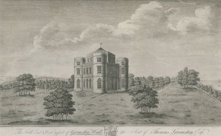
Grimston Garth Listed Grade IGrimston Garth was designed by the architect John Carr as a romantic Gothic-style summer residence by the sea for Thomas Grimston. The original part of this castellated house, built 1781-86, is most unusual as it is triangular in shape with a central hexagonal room on each floor and a circular turret at each corner. On the ground floor the hexagonal Gothic dining room is decorated with shields displaying the heraldry of the Grimston family. The house was extended to the north with two service wings in a similar Gothic style around 1812. (Pevsner & Neave, Yorkshire, York and the East Riding, 445-6)
Stable block Listed Grade IIOf the 1780s by John Carr. Single storey of red brick around a courtyard with a castellated two-storey central tower. The doors and windows have Gothick arched openings.
Gardens And Pleasure Gardens
There probably has never been any extensive area of gardens at Grimston. Today the gardens, as distinct from the parkland and plantations, lie to the north-east of the house. Here is an area of shrubs and to the north the present kitchen, flower and pleasure gardens.
Kitchen garden
The former late 18th-century walled kitchen garden is occupied by an extensive collection of laboratories and housing for animals. It is an animal testing centre. Most of the original walling survives.
Park
A comparison of the 1850s Ordnance Survey map (top) with a recent Google Earth air view (2007) show comparatively little change to the extent and character of the parkland and surrounding plantations of Grimston Garth. The only significant change is to the south where there has been additional planting but this is not part of the setting of the house. The parkland is still characterised by clumps of trees dotted about, except in the eastern section, and the area is still bounded by perimeter plantations.
Books and articles
M.E. Ingram, Leaves from a Family Tree, 1951
M.E.Ingram, ‘John Carr’s Contribution to the Gothic Revival’, Georgian Society for East Yorkshire Transactions, 2, pt. 3, 1947-8, 43-52
G.H.R. Kent (ed), Victoria County History, Yorkshire, East Riding, VII, 2002
D. Neave & D. Turnbull, Landscaped Parks and Gardens of East Yorkshire, 1992
N. Pevsner & D. Neave, Yorkshire, York and the East Riding, 1995
Deborah Turnbull, ‘Thomas White (1739-1811): Eighteenth Century Landscape Designer and Arboriculturist’, PhD thesis, University of Hull, 1990
Primary sources
East Riding Archives and Local Studies Service (ERALS) Beverley, DDGR. Records of the Grimstons of Grimston Garth and Kilnwick.
Newspapers
Hull Packet
Morning Post
Maps
H. Teesdale, Yorkshire, surveyed 1817-18, published 1828
A Bryant , East Riding surveyed 1827-8, published 1829
Ordnance Survey maps published 1855 -2012.


")