Soon after the original Sedbury Hall was built, probably in the 15th century, the grounds around it were laid out with a ‘little park’ and fishpond. These remained largely unchanged until the 18th century when the Darcy family, who had acquired the estate in 1684, started making changes first to the hall and then the wider landscape. About 1775, Sir Robert D’Arcy Hildyard called in the well-known landscape designer, Thomas White, to remodel the grounds after he had employed the architect, John Carr, for the hall and other buildings on the estate. The exact design by White is unknown but a plan from 1824 probably reflects the changes made including an area of parkland, plantations, shelter belts and pleasure grounds around the hall and a new walled kitchen garden.
The estate was sold to the Rev. John Gilpin in 1826 and his cousin, William Sawrey Gilpin, not only stayed for long periods at Sedbury but also provided some design ideas, as he had latterly taken up a career as a landscape designer. It is not clear how much of his plans were implemented although John Gilpin’s son, George Gilpin Brown, did make a number of changes on inheriting in 1844. These included extending the parkland and adding to the plantations. He also enlarged the kitchen garden and added glasshouses in its interior.
With the death of George’s son in 1918, Sedbury Hall was sold a year later but the new owner could not afford to keep it and so it once again it was put up for sale in 1925. Although the wider estate lands and farms were bought, the hall and immediate grounds had no buyer. The decision was made therefore to demolish the hall in 1927 and sell off the land. Charles Webb acquired it and the following year built a new hall on the site of the former mansion. This meant that the surrounding designed landscape survived and continues to be legible today.
Estate owners
Sedbury is not specifically mentioned in the Domesday book but it is likely that it was part of the extensive holdings of Count Alan that centred on Richmond. By 1086, he had granted these to Alan Rufus, 1st Lord of Richmond. By 1284/5, ‘Over Sadbergh’ had one carucate of land (c. 120a) held by William de Barningham from the Earl of Richmond and ‘Nether Sadbergh’ had the same area held by John de Skargill from the Earl of Richmond via William of Skargill and Roald of Richmond (HMSO 1938, 97). In 1348 and 1350, William le Scrope and his wife, Katherine, bought land in ‘Sadbergh near Richmond’ (possibly the holdings in Over Sadbergh held by the de Barningham family) from William and Emma Stele and Roger and Joan de Welles respectively (YAS 1915, 11 & 29).
By 1435, Christopher Boynton appeared to have acquired the manor of Sedbury and associated lands, probably through his wife, Joan (PRO 1937, 361). His grandson, Henry, died in 1531 and the estate went to his daughter, Isabella, and her husband, Henry Gascoigne. It remained in the Gascoigne family until 1641 when on the death of Sir William, his daughter, Isabel, and son-in-law, Sir Marmaduke Wyvill 2nd Bt, inherited it. Sir Marmaduke’s grandson, Sir William (4th Bt) sold Sedbury to his cousin, Christopher Darcy, in 1684 (DRO D258/23/18/14).
Christopher Darcy died without issue in 1692 and it passed to his brother, James (later 1st Lord Darcy of Navan). On the latter’s death in 1731, his grandson, James Darcy (né Jessop) was his heir but only lived a further two years. Under the terms of his grandfather’s will, the estate then passed to the next male heir, Henry Darcy, on whose death in 1752, it was inherited by his grandson, Robert D’Arcy Hildyard. He also had no male heirs, so again the estate passed to the next male in line, James Henry D’Arcy Hutton, in 1814.
Hutton sold Sedbury to the Reverend John Gilpin in 1826 and it remained with the Gilpin Brown family until 1919 when it was sold to Mr George E. Sisterton. The estate was put up for sale in 1925 but the house and 267 acres failed to sell and the hall was demolished. Two years later the site was sold for its land and building materials and the new owner, Charles Webb, built a new house. This was bought by Brigadier Henry Conyers Baker Baker and the new hall and grounds remain in his family’s possession.
Key owners responsible for major developments of the designed landscape and dates of their involvement:
Christopher Boynton c. 1435 – 52
Sir Henry Gascoigne 1531 – c. 1543
Sir William Gascoigne 1604 – 41
James Darcy (1st Lord Darcy of Navan) 1692 – 1731
Sir Robert D’Arcy Hildyard c. 1764 – 1814
Rev. John Gilpin 1826 – 44
George Gilpin Brown 1844 - 89
Early history of the site
From the time of the Norman Conquest, the land that would form the Sedbury estate was divided into separate areas with multiple owners. A survey of the lands owned by the Earl of Richmond in 1284/5 listed Gilling (West) with ‘Over Sadbergh’ and ‘Nether Sadbergh juxta (near) Skeeby’. The former had 2 carucates of (arable) land of which William de Barningham held one (c. 120a) from the Earl. Nether Sedburgh also had one carucate, which John de Skargill held of William of Skargill and William held this from Roald of Richmond, and Roald from the Earl (HMSO 1938, 97).
This was clearly only part of the lands as in 1348, William le Scrope and his wife, Katherine, paid 20 marks to William Stele of Ripon and his wife, Emma, for ‘1 messuage, 2 carucates of land, 24 acres of meadow, and 100 acres of pasture in Sadbergh near Richmond’ (YAS 1915, 11). This was followed 2 years later by a purchase by William and Katherine le Scrope from Roger de Welles and his wife, Joan, of ‘1 messuage, 2 carucates of land, 30 acres of meadow, and 1,000 acres of pasture in Sadbergh near Richmond’ for 100 marks (ibid, 29). Both of these purchases are likely to have been in Over Sedbury.
William le Scrope was the younger brother of Henry, 1st Baron of Masham and after William’s death in 1367, the lands at ‘Over Sedbury’ went to Henry and then his youngest son, John and his wife, Elizabeth (PRO 1992, 27-50). The manor or lands at ‘Nether Sedbury’ though was held in 1386 by Henry FitzHugh of Ravensworth Castle (Yorkshire) for Thomas de Mowbray, Earl of Nottingham (PRO 1974, 143). In 1425, the Inquisition Post Mortem on 6 July of Sir Henry FitzHugh (son of Henry) stated he owned:
‘Sedburgh, the manor, in which there are the site, worth nothing yearly; 60a. demesne land, each acre worth 6d. yearly; 5a meadow, each acre worth 2s yearly, a watermill worth 13s 4d yearly; 20 cottages with 20 crofts and 20 closes adjacent to the cottages, worth £4 yearly.’ (PRO 2003, 390)
In 1427, Thomas Clarell junior and his wife, Elizabeth, gave Henry Percy, Earl of Northumberland, Richard Neville, William FitzHugh, RobertFitz Hugh, Christopher Conyers and John Thoralby seisin (freehold) of the manor of Sadberry by Gyllynge (Sedbury by Gilling) and lands there (PRO 1933a, 342-3). This was listed as having one messuage, 10 bovates (c. 150a) arable land, 20a meadow, 100a pasture and 100a of moor (Plantagenet-Harrison 1885, 114). This was confirmed 7 years later when Thomas Clarell relinquished the ‘manor of Sadberry within the liberty of Richmond’ to the Earl of Northumberland, Richard Neville and Christopher Boynton (PRO 1933b, 361). This document is the first to mention Boynton, whose wife, Joan, may have been the daughter of Thomas and Elizabeth Clarell, hence his claim to Sedbury. He was certainly living there by 1444, when an indenture involving him was dated at Sedbury on 25 April (YAS 1922, 22). On 2 December 1455, a licence was granted from the Archbishop of York’s vicar-general to Dame Joan Boynton of Sedbury to have masses celebrated in her oratory there, for two years (Hamilton Thompson 1931, 115).
When Christopher Boynton junior died in 1485, he held 1 carucate of land in Over Sedbury of Henry Lord Scrope of Bolton and same in Nether Sedbury of the King. He was also seised of manor of Sedbury, which he held jointly with Sir Robert Conyers of Ormesby and John Conyers of Hornby, with remainder to John Conyers by deed of entail 16 June 1458/9 (Plantagenet-Harrison 1885, 115). Christopher’s son, Henry, married Barbara Lumley who brought estates at Ravensworth in County Durham. On Sir Henry’s death in 1531, his sole heir was his daughter Isabella, who married Henry Gascoigne. Just before the latter’s death c. 1544, John Leland visited and observed that
‘Sr Henry Gascoigne dwellith at a pretty place called Sedbyri, having a pretty park and a little lake in it. It is a 3 miles be north from Richmond’ (Toulmin Smith 1909, 28).
In 1607, Sir William Gascoigne (Sir Henry’s great-grandson) sold the manors of Ravensworth, Lomersley and Ravensholm to Thomas Liddell shortly after inheriting from his father, presumably to develop his estate at Sedbury. The following year, the manor of Sedbury was described as having 2 messuages, one mill, one dovecote, 140 acres of arable land, 100 acres of meadow, 250 acres of pasture and common of pasture and free warren in Sedbury and Gaterley Moor (Plantagenet-Harrison 1885, 117)
By 1613, the manor of Sedbury had expanded to:
7 messuages, 5 barns, 1 water-mill, 1 dovecote, 7 gardens, 200 acres of arable land, 100 acres of meadow, 250 acres of pasture, 10 acres of wood, 300 acres of juniper and briar, 300 acres of moor, common of pasture etc in Sedbury, Eppleby and Gaterley Moor (ibid, 117)
The manor then devolved to the Wyvill family with the marriage of Sir William’s daughter, Isabella, to Sir Marmaduke, 2nd Bt of Constable Burton. As a secondary property, it was sold to Christopher Darcy in 1684 for £6,350, shortly before the death of Sir William Wyvill 4th Bt to pay off the latter’s debts (DRO D258/23/18/14). After Christopher’s death in 1692, his brother, James, inherited and had made significant changes to the property when John Warburton visited on 21 February 1719, as he observed: ‘I went to Sadbury, the seat of (James) Darcy, esq, which is a most beautiful seat, and most of his own erecting, very richly furnished on the inside’ (YAS 1900, 67).
At the same time, Samuel Buck sketched the ‘south prospect’ of the hall, to the south of which was a wall, gates and steps leading to a garden with an avenue of trees (Hall 1979, 357). To the east in front of the main entrance was a walled courtyard and gates with buildings (stables?) adjacent (ibid). From this it would appear that the carriageway from the public road was to the north that ran from Gilling to Kneeton and is shown on Warburton’s map of the time (Figure 1).
James Darcy’s will ensured that the estate had to pass to male heirs in a codicil made on the 5 March 1726 (NYCRO ZUH MIC 1728) and so on the early death of his grandson in 1733, it was Henry Darcy, his cousin, who inherited. When Henry died in 1752, it was left in trust to his grandson Robert D’Arcy Hildyard until he came of age in 1764.
Chronological history of the designed landscape
1771 – 1823While the main residence of the Hildyard family was at Winestead in the East Riding, Robert D’Arcy, had started to make alterations at Sedbury by 1771, employing the architect, John Carr. On 12 October of that year, his father wrote to John Grimston:
‘Carr has indeed shown great skill in the alterations of the old house at Sedbury...My son has six good bed chambers, besides one of the most convenient Apartments for himself and Mrs Hildyard that I know of in an old house. Must build new Stables and a kitchen garden but as he is now well lodged, I hope he will go on with the other improvements gently’ (ERA DDGR/42/21/134).
He seems to have taken his father’s advice as the ‘improvements’ continued over the next twenty years. He first got a plan for a greenhouse/hothouse in 1774 (ERA DDHA 57/5/19, Figure 2). This may have been designed by Carr, who notes: ‘Tell the Joyner to see(?) the sash squares at Rokeby upon the Hot house, and in making the sash frames at Sedbury he must not exceed the size of the squares at Rokeby’ (ibid). Rokeby Park, 9 miles northwest of Sedbury, was the property of John Sawrey Morritt who had employed Carr at this time. In 1775 the designer, Thomas White, was engaged as a letter from Thomas Grimston to Hildyard dated 30 July, mentioned his employment at Sedbury (Cox & Johnson 1985, 84). White was paid 50 guineas on the 7 December from RD Hildyard ‘per letter’ (Natwest Archives, White bank accounts). Although no plan survives, the amount would indicate a survey and an improvement plan were provided by White.
Whether work started immediately in 1775 is unclear as the only archive evidence is Hildyard’s personal account book (ERA DDHI/58/19/3), where entries for Sedbury start in 1778. There are references that year to the building of a garden shed and melon frames and the laying of a greenhouse floor (possibly the one that was designed by Carr, Figure 2). There are significant labourers’ costs incurred by David Peter, the gardener, particularly from March to September when at least £36 was spent (ibid). It is possible that these relate to the new kitchen garden and some landscaping around it as the nurseryman, Thompson, was paid £10 12s 10d for ‘seeds & trees’ on 12 October (ibid).
There is a break in the account book after January 1779 and entries for Sedbury start again in 1784. This was possibly to allow the new stableblock to the north to be built and the removal of the buildings to the east shown in Buck’s sketch (Hall 1979, 357). Whilst David Peter was still the gardener and being paid for labourers’ costs of about 18s a week, Thomas Scott, probably a foreman for White, was employed from about mid-December 1783 (ibid). From then to 11th December 1784, his bill for labourers came to £67 3s with Hildyard noting that £108 7s 7d had been spent on ‘Improvements in the grounds at Sedbury’ that year (ibid). Scott died about 11 December as Hildyard noted a payment of £18 18s to ‘Mary Scott her late husband’s wages due Jan 31st 1785’ on 31st December (ibid). His foreman’s death perhaps explained why on the 23 December, White advised Lord Mulgrave that: ‘[I] shall be glad to receive the favour of your instructions on that head at Sir Robt Hildyards Bart at Sedbury near Richmond, Yorks’ (MCA VI.10/336) as he had to temporarily take over supervising the work.
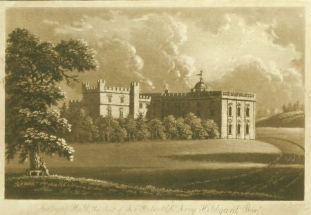
By 20th January 1785, Michael Woodhall had been taken on as replacement for Thomas Scott with David Peter remaining as gardener until mid-May (ERA DDHI/58/19/3), with Woodhall then taking on the latter’s role. The account book gives a figure of nearly £142 for ‘Work at Sedbury’ in 1785 and £208 in 1786, although it may not be specifically for the grounds. In 1787, £503 spent on the estate including an icehouse to the north of the kitchen garden and a bridge over the sunk fence for the carriageway from the northern entrance (now off the A66). The plan of estate from 1824 (Turnbull & Wickham 2022, 233) shows the kitchen garden, parkland and plantations to the north and west. A sunk fence divides the northern perimeter plantation from the parkland with another encircling the Hall and stables. It is possible that this layout dates from the work outlined above. An engraving of a painting by Cuit in 1798 shows the shrubbery to the west and southern façade of the hall (Figure 3). In 1797, the folly known as ‘The Rock’ southeast of the hall was built to a design by John Foss of Richmond (Figure 4).
In 1810, an Enclosure Act was passed for the neighbouring Gilling parish and on the 26 September of that year, Hildyard wrote to the Commissioners for his allocation of land including:
‘Lower New Close, Upper New Close and High Pasture and also…parcels of land…into Sedbury Lawn by a sunk fence, all of which…are in the occupation of myself and Anthony Lay which…contain by estimation fifty acres…of which I am tenant for life. And I do hereby further claim to be entitled to a proportionate share…upon…Gatherley Moor and the said waste lands…at Sedbury in the Township of Gilling…and in the Township of Skeeby…containing…by estimation one thousand acres…in occupation of myself [and others]…and are of freehold tenure and of which I am tenant for life’ (NYCRO ZQX 4/14/2a).
Hildyard’s allocations can be seen on the enclosure map of 1814 (NYCRO I-NRRD11A4C).
Sir Robert D’Arcy Hildyard died in 1814 and according to the entail on the estate, his cousin, James D’Arcy Hutton, succeeded him. Hutton put up the estate for sale on 29 January 1821, however it failed to sell. It was described as:
1824 – 1918‘Mansion House called Sedbury Hall…together with the Manor or Reputed Manor of Sedbury and the Park, Plantations and other Lands…containing…870a…of rich arable, meadow and pasture land…The Mansion House is most delightfully situated, is in excellent repair, the Trees in the Gardens, Green-House, Vinery etc are in full bearing and the Grounds are laid out in great taste and form altogether one of the most desirable Residences…The Park and other Lands are well wooded…Forty Thousand Pounds, part of the Purchase Money, may remain on Security of the Estate if required.’ (Yorkshire Gazette, 27 January).
The 1824 estate plan showed a slightly reduced estate of 861 acres that was bought by Rev. John Gilpin on 7/8 August 1826 for £50,000 (NYCRO ZQX 1/9/13/1). To finance this, he took out a mortgage for £24,000 plus interest of £2,000, payable in instalments: £3,000 on 13 May 1829, £3,000 on 13 May 1832 and £20,000 on 23 November 1834 (NYCRO ZQX 4/14/4). A survey from c. 1843 (NYCRO PR/GIL 14/4) showed that he had increased the area ‘in hand’ to just over 146 acres from 78 acres. The areas called ‘Loose House Field’, ‘Cow House Field’, ‘Rush Hills, ‘Coach Road’, ‘Middle Street Close’ and ‘East side of Middle Street Close’ that had been tenanted in 1824, were now part of the designed landscape. The first three were probably in the park and the last two were next to the northern entrance, perhaps following the construction of the lodge there.
These changes may have been influenced by his cousin, William Sawrey Gilpin, who had regularly stayed with John Gilpin until the former’s death there in April 1843. W. S. Gilpin had taken up a career as a landscape gardener in 1820 following a long period as a painter (Piebenga 1994, 177). He provided some design ideas for Sedbury including a 12ft wide terrace walk about 350ft from the hall, parallel to the south front, with a seat at one end (ibid, 187). Piebenga comments:
‘It is unlikely that Gilpin’s proposals were carried out exactly as he suggested. However, the basic layout today is as he intended, although his terrace walk appears as little more than a slightly raised level grass bank’ (ibid).
He also made suggestions for planting in the park at Sedbury via a sketch (ibid, 189). It was to be in the northeast corner of the park, where there was a belt of planting, ‘which must have horrified Gilpin. Probably in an effort to relieve its monotony he suggested two irregular plantations to be placed in front of it’ (ibid, 190-1). Judging by the 1st edition 6” OS map that was surveyed in 1854 (Figure 5), it does not appear that his cousin took his advice.
In 1844 John Gilpin died and his son, George Gilpin Brown, soon started making changes after inheriting. A valuation from 7 April 1845 (NYCRO ZQX 4/14/2b) showed that the land ‘in hand’ had risen again to just over 209 acres, with an extra 16 acres of woods and plantations and the area of the mansion, offices, gardens and pleasure grounds had increased by just over 2 acres. The latter was probably the extension of the walled garden area to the south. By 1 May 1846, the mortgage had been paid off (NYCRO ZQX 4/14/4) and Gilpin Brown continued to develop the grounds as shown in the 1st edition 6” OS map in 1854 (Figure 5). To the northeast of the kitchen garden, a heated orangery and fruit house had been built replacing the dog kennel. In the wider landscape, the woodland known as ‘Fox Covert’ had been put in east of the lodge and carriageway and the parkland had been expanded to the southwest in the former ‘Gilling Pasture’. On the eastern front entrance, there was now a courtyard that is shown on a drawing published in Plantagenet-Harrison (1885, 112) (Figure 6).
George Gilpin Brown died on 28 November 1889 and his son, George Thomas, inherited the estate. The 2nd edition 6” OS map, surveyed in 1891/2 (Figure 7) showed a further expansion of parkland to west covering the former ‘High Pasture’, ‘Upper New Close’ and ‘Lower New Close’ and to the east on the former ‘West Mulberry’ field. The ‘Sedbury Plantation’ had also been created between the ‘Whin Covert’ (formerly The Fox Covert) and ‘Barracks Barn Plantation’. In the walled kitchen garden, there were additional glasshouses in main part of on north wall and in northeast corner (1st edition 25” OS map, Figure 8).
Later historyAfter the death of George Thomas Gilpin Brown in 1918, the estate was put up for sale and sold to George E. Sisterson for £36,000 (NYCRO ZQX 1/7/28) the following year. By 1925, Sisterton was struggling to keep the estate and so once again, it was offered for sale on the 30 March. Lot 1 contained the hall, lodge, two gardeners’ cottages, gardens, plantations and the park of 160 acres, amounting to 267 acres in total but it failed to sell (NYCRO ZKC 22). However, the four farms and the remaining land were sold off. As Sisterton could not afford to keep it, the hall was demolished in 1927 and sold for building materials (NYCRO ZKC 24). A new house was built on the site though the following year by the new owner, Charles Webb. In 1947, it was bought by Brig. Henry Conyers Baker Baker.
Location
Sedbury Park is 3 miles (5km) northeast of Richmond and a mile (1.7km) west of Scotch Corner.
Area
The historic designed landscape at its greatest extent was 429 acres (173 hectares).
Boundaries
The eastern boundary lies along the A66 from its most northerly point at NZ 200 061 until NZ 209 053 when it follows the northern edge of Sedbury Plantation until Barracks Barn Plantation. The southern boundary follows the southern edge of the Barracks Barn Plantation and then Sedbury park until Sedbury Park Farm. The western boundary runs from Sedbury Park Farm along the road from Gilling to NZ 191 050 when it continues north along the edge of Sedbury Park to NZ 198 060 and then follows the narrow plantation to the A66.
Landform
The majority of the designed landscape lies on the underlying Alston Formation bedrock with limestone and some sandstone. This is overlain with sedimentary superficial deposits that gives rise to mainly slowly permeable, seasonally wet acid loamy and clayey soils with impeded drainage and low fertility except for the northwest of the park where it is freely draining.
Setting
Sedbury Park is in the North Yorkshire Local Landscape Character Area of ‘Moors Fringe’. This is a gently sloping landscape forming a transition between higher moors and fells to the west and the lower magnesian limestone ridge to the east. It is a predominantly rural landscape. Sedbury Hall itself lies at 140m AOD with the land rising to the north and east to a height of between 170m to 175m OD. To the south and west, the land falls to 100m OD.
Entrances and approaches
Lodge [Grade II – NHLE 1316934]Northern entrance off A66, with carriageway through park southwest to hall. The HE listing dates it to late 18th or early 19th century, possibly by John Foss, although it does not appear on the 1824 map nor is listed in the 1821 sale document. It may therefore be later in the 1st half of the 19th century.
Northern carriagewayLeading from the main road (now A66), this carriage route through the park was probably constructed between 1784 and 1787 to the design of Thomas White.
Southern entranceOff the road from Gilling was an entrance to a carriageway joining the northern route and leading to the hall. It was in place by 1824 but may also be part of the works carried out in the 1780s.
Principal buildings
Sedbury HallCurrent main residence built in 1928 on site of former hall.
Former Sedbury HallParts of this may date back to 15th century although it was remodelled in the early 18th century. It was demolished in 1927.
Stables [Grade II – NHLE 1316933]The HE listing dates it to late 18th or early 19th century, possibly by John Foss. However it may have part of the earlier works by John Carr in the 1770s.
Orangery and fruit house [Grade II – NHLE 1131920]Later gardeners’ cottages, the central section shows evidence of being heated. The HE listing dates it to late 18th or early 19th century, probably by John Foss, however the 1824 map shows a dog kennel in the area and this is also mentioned in the c. 1843 survey. It is though shown on the 1st edition OS map, surveyed in 1854, so it must have built between these dates.
The Rock [Grade II – NHLE 1131922]In extreme southeast part of the park, this folly was built in 1797 to the design of John Foss of Richmond.
Icehouse [Grade II – NHLE 1301163]Built in the autumn of 1787 (ERA DDHI/58/19/3). It is described in the HE Listing as: ‘Brown brick. Circular in plan, with deep well and tall domed vault above. Small inner doorway at far end of short barrel- vaulted passage, with round-arched entrance doorway. Partly built into the hillside, but the structure forms a man-made mound in a wood.’
Gardens and pleasure grounds
The sketch by Buck c. 1720 showed there was a garden to the south of the hall with an avenue of trees leading away from it. This was removed during the alterations in the 1780s when a sunk fence was put in encircling the hall. The western section of this enclosed area was laid out with trees and shrubs and the eastern part left open with views towards the parkland. The area south of the hall was remodelled between 1826 and 1854, possibly to the designs of William Sawrey Gilpin, with a raised walk 350ft south of the hall.
There were no further changes until the estate was put up for sale in 1925. The description from 1925 sale catalogue (NYCRO ZKC 22) described the grounds: ‘The Gardens round the House include a Large Lawn to the South, which is separated from the Park by a ha-ha. Part of this is levelled for Croquet and part is undulating and ornamented with fine trees. Near the House is a paved walk with wide rose border leading to the lower Lawn, surrounded on three sides by yew hedges. Delightful woodland walks lead to the tow walled Gardens. One includes a large Lawn with rose beds, double herbaceous border with paved walk…A special feature of the Pleasure Grounds is THE LAURELS WALK PLANTATION, with its winding walks shaded by shapely beech and other forest trees’.
Kitchen garden
The northern section of the walled kitchen garden was probably built in the first phase of landscaping from c. 1771 to 1778, when a garden shed was built (ERA DDHI/58/19/3). Hildyard had commissioned a greenhouse in 1774, possibly by John Carr (see Section 3.3.1) and it must have been built by 1778, as there was a bill for ‘laying green house floor’ on 5 October (ibid). There were also payments to the joiner and glazier for making melon frames on 29 September and 5 October respectively that year (ibid). Bark was bought on 21 February 1785 (ibid), presumably for the frames and a stove on the 24 October, possibly for the greenhouse. The location of the latter is unknown as no building is shown on the 1824 plan, although there is mention of a greenhouse and vinery in the sale advert of 1821.
By 1925, there is a full description from the sale catalogue: ‘the two walled Gardens. One includes…Two Vine Houses and Conservatory. The other is mainly devoted to fruit and vegetables and there are also other Glass Houses, Gardeners’ Bothy with various useful lean-to buildings on the North side of the North wall for gardeners’ tools, implements etc.’ (NYCRO ZKC 22).
Park and plantations
Sedbury ParkLeland mentions a ‘little park’ when he visited in the early 16th century, although its extent is unknown but would have been adjacent to the hall. By 1824, the parkland extended to just over 141 acres and at its greatest extent at the end of the 19th century covered nearly 250 acres, having been extended primarily to the west and the south.
Laurels Walk PlantationThis is located north of the hall and around the walled kitchen garden and icehouse and covered 15½ acres. This was probably planted in the 1770s as part of White’s design, although it may be earlier as the old fish pond is located there.
Beeches Walk PlantationForming the northeast boundary of the park and extending to just under 8 acres, this too was probably part of White’s design of the 1770s.
Whin CovertThe Whin Covert was originally a narrow strip next to the carriageway from the lodge but was extended in the second half of the 19th century to 9¼ acres.
Sedbury PlantationOriginally called the Fox Covert on the opposite side of the carriageway to Whin Covert, it was enlarged to just over 57 acres by late 19th century to join up with the small Barracks Barn Plantation to the south.
Belt PlantationDescribed as the ‘Long Nursery’ on the 1824 plan, this too was probably part of White’s design, as it screened the estate from the main public road (now A66).
Water
A fishpond is mentioned by Leland and to the north of the hall is a circular pond called ‘Old Fish Pond’ on OS maps.
Books and articles
Cox, A. and Johnson, H. A. 1985. The Architecture of Grove Hall, Nottinghamshire. Thoroton Transactions LXXXIX, 75-85.
Hall, I. 1979. Samuel Buck’s Yorkshire Sketchbook. Wakefield, Wakefield Historical Publications.
Hamilton Thompson, A. 1931. The Register of the Archdeacons of Richmond, 1442-1477. Yorkshire Archaeological Journal 30, 1-134.
HMSO 1938. Inquisitions and assessments relating to feudal aids, with other analogous documents preserved in the Public Record Office, 1284-1431. London, HMSO.
Piebenga, S. 1994. William Sawrey Gilpin (1762-1843): Picturesque Improver. Garden History 22 (2), 175-196.
Plantagenet-Harrison, G. 1885. The History of Yorkshire, Wapentake of Gilling West. London, Hazell, Watson and Viney Limited.
PRO 1933a. Calendar of Close Rolls, Henry VI 1422-9. London, HMSO.
PRO 1933b. Calendar of Close Rolls, Henry VI 1429-35. London, HMSO.
PRO 1937. Calendar of Close Rolls, Henry VI 1435-41. London, HMSO.
PRO 1974. Calendar of Inquisitions Post Mortem: Volume 16, Richard II. London, HMSO.
PRO 1992. Calendar of Inquisitions Post Mortem: Volume 19, Henry IV. London, HMSO.
PRO 2003. Calendar of Inquisitions Post Mortem: Volume 22, Henry VI. London, HMSO.
Toulmin Smith, L. ed. 1909. The itinerary of John Leland in or about the years 1535-1543, Parts VII and VIII. London, G. Bell & Sons.
Turnbull, D. and Wickham, L. 2022. Thomas White (c. 1736-1811): Redesigning the northern British landscape. Oxford, Windgather Press.
YAS 1900. Journal in 1718-19 of John Warburton. Yorkshire Archaeological Journal 15, 16-84.
YAS 1915. Feet of Fines for the county of York from 1347 to 1377, Yorkshire Archaeological Society Record Series, Volume 52. Leeds, Yorkshire Archaeological Society.
YAS 1922. Yorkshire Deeds Vol. iii, Yorkshire Archaeological Society Record Series, Volume 63. Leeds, Yorkshire Archaeological Society.
Primary sources
Derbyshire Record Office (DRO)D258/23/18/14 Acknowledgement of sale of Sedbury by Sir William Wyvill to cousin Christopher Darcy, 3 Sep 1684
East Riding Archives (ERA)DDGR/42/21/134 Letter from Robert Hildyard to John Grimston, 12 October 1771
DDHI/57/5/19 Sedbury mansion house architectural sketches of building alterations, 1774-1800
DDHI/58/19/3 Personal account book of Sir Robert D’Arcy Hildyard, 1778-87
Mulgrave Castle Archives (MCA)VI.10/336 Letter from Thomas White to Lord Mulgrave, 23 December 1785
North Yorkshire County Record Office (NYCRO)I-NRRD11A4C Enclosure map for Gilling West, 1814
PR/GIL 14/4 A copy of the valuation of Sedbury, taken in 1843
ZKC 22 Sale catalogue for Sedbury Park estate, 1925
ZKC 24 Sale catalogue of building materials from Sedbury Park, 1927
ZQX 1/7/28 Note of Sedbury purchase by Sisterton in 1919
ZQX 1/9/13/1 Note of Sedbury purchase by Brown on 7/8 August 1826
ZQX 4/14/2a Letter to John Humphries, Enclosure Commissioner from Sir Robert D’Arcy Hildyard, 26 September 1810
ZQX 4/14/2b A valuation of the Sedbury estate made 7 April 1845
ZQX 4/14/4 Transfer of mortgage on Sedbury estate, 1851
ZUH MIC 1728 Will of James Darcy, Lord Darcy of Navan with codicil, 1726
Private CollectionA Plan of Sedbury Estate the property of James Henry D’Arcy Hutton made November 1824 by Thomas Bradley, Richmond
Maps
Ordnance Survey 1st edition 6”, surveyed 1854, published 1854
Ordnance Survey revised edition 6”, surveyed 1891-2, published 1895
Ordnance Survey 1st edition 25”, surveyed 1891, published 1893
Figure 1 – Map by John Warburton c. 1720 showing road from Gilling to Kneaton to the west of Sedbury Hall
Figure 2 – Plan for a greenhouse possibly by John Carr, 1774. East Riding Archives, DDHI/57/5/19
Figure 3 – Engraving of Sedbury by George Cuit, 1798. Gott Collection, The Hepworth Wakefield
Figure 4 – ‘The Rock’, a folly in the park at Sedbury by George Cuit c. 1798. Gott Collection, The Hepworth Wakefield.
Figure 5 – Sedbury Hall gardens and parkland from 1st edition 6” OS map surveyed in 1854. National Library of Scotland CC-BY.
Figure 6 – East front of Sedbury Hall from Plantagenet-Harrison, G. 1885. The History of Yorkshire, Wapentake of Gilling West, 112.
Figure 7 – Sedbury estate showing new plantations and extension of parkland from revised 6” OS map surveyed in 1891/2. National Library of Scotland CC-BY.
Figure 8 – Pleasure grounds and walled kitchen garden at Sedbury from 1st edition 25” OS map surveyed in 1891. National Library of Scotland CC-BY.


