For nearly a millennium, the designed landscape in Skelton has been shaped by the owners of the castle. Initially a defensive structure, it later became a high-status building and was surrounded in the medieval period by gardens and orchards in a ‘little park’ with further large enclosed areas to the south and west that served as hunting parks. Over time, these areas were divided into smaller parks and by the beginning of the 18th century, two small walled parks remained.
Skelton Castle itself began to deteriorate from the mid-15th century as it ceased to be a primary residence and then became a divided inheritance. Once entirely in the hands of the Trotter family from the mid-17th century, it was subject to remodelling and rebuilding over the next 150 years. These changes impacted on the immediate grounds and in 1775, the then owner, John Hall Stevenson, employed Thomas White to produce an improvement plan for the area. Although only the kitchen garden was implemented from this plan, major changes were undertaken by Stevenson’s grandson, John Wharton, in the 1790s, possibly under the direction of Adam Mickle junior. This included a new moat around the castle, a fishpond, a lodge with a carriageway over a bridge to the castle and parkland to the west.
Wharton, despite having inherited a large fortune, went bankrupt in 1829 and so little was done to the estate either by him or his successor until the 1860s. By this stage, ironstone mining had started on the site of two of the former parks and Wharton’s nephew, John Thomas, benefited from the royalties. Apart from draining the moat, he made no significant changes and it was his son, William, who made some minor modifications including moving the main entrance to Marske Road to create the landscape that we see today.
Estate owners
Skelton Castle and its lands came into the possession of Robert de Brus sometime between 1110 and 1119. It remained with the family until Peter de Brus III died in 1272 without male heirs. His sister, Agnes, and her husband, Walter de Fauconberg, inherited the portion of the estate that included Skelton. The Fauconberg family held it until 1490 when it passed to William Conyers, grandson of Joan de Fauconberg. On his grandson’s death in 1557, there were no male heirs again and the estate was divided between his three daughters. One of the daughters, Anne, and her husband, Anthony Kempe, sold their share to Robert Trotter in 1576 (Graves 1808, 353). His descendant, Edward Trotter, bought the other two-thirds of the estate in 1654 and 1656 (ibid, 354).
On Edward Trotter’s death in 1708, his grandson, Lawson, inherited but in 1727, he sold the estate to his sister and her husband, John Hall. Their son, John, succeeded in 1733 and in 1740, he married Ann Stevenson, adding her surname to his. His son only outlived his father by a year and so in 1786, it was John’s grandson, also John, who inherited. Following an inheritance from Margaret Wharton, John Hall Stevenson changed his name to Wharton in 1788. John Wharton had no children and on his death in 1843, his nephew, John Thomas, became the new estate owner. It remained the property of his descendants until 1991, when it passed to a distant cousin.
Key owners responsible for major developments of the designed landscape and dates of their involvement:
Richard de Surdeval c. 1072 - 1110
Adam De Brus II c. 1190 – c. 1198
Peter De Brus I c. 1198 – 1222
Peter De Brus III 1240 – 1272
Walter de Fauconberg 1272 – 1305
John de Fauconberg 1305 – 1349
Robert Trotter 1576 - 1611
Edward Trotter c. 1656 – 1708
John Hall (later Hall Stevenson) c. 1739 – 1785
John Hall Stevenson (later Wharton) 1786 – c.1829
John Thomas Wharton 1843 – 1900
William H.A. Wharton 1900 - 1938
Early history of the site
The pre-Conquest village of Skelton had probably suffered some damage during the laying waste of much of northern England in 1070 to quell resistance to the Norman invaders. One of the Norman knights, Richard de Surdeval, had been granted the land and built a wooden castle on the site c.1072-5 (I’Anson 1913, 380-1). In the Domesday book of 1086, there was c. 840 acres of arable land, 20 acres of meadow and c. 1500 acres of woodland, giving a total area of c. 3.7 square miles in Skelton (https://opendomesday.org/place/NZ6518/skelton/ accessed 25 November 2022). Although Robert de Brus came into possession of the lands in the early part of the 12th century, it appears little was done at the estate until his descendant, Adam de Brus II, converted the timber castle into stone with rectangular keep c. 1190 - 1198 (I’Anson 1913, 383). In 1216, King John laid siege to the castle and by this time, Peter de Brus I had probably built the chapel (ibid, 384).
When Robert de Brus granted lands to found Gisborough Priory in 1119, he excluded ‘Haia’ and ‘Asadala’ (Surtees 1889, 1-2). The former was probably an enclosure, which was near or attached to the castle built by de Surdeval. Asadala or Asadale was a forested area, part of the extensive woodland mentioned in the Domesday book for both Skelton and neighbouring Guisborough (c. 750 acres) and located in the southern part of the region. While the former may have been a park, the first mention of the designed landscape was in 1242 when Peter de Brus III was granted ‘in the enclosure of Skelton enclosed on the north side of Routheclive [Rawcliff bank] and in a small park about the castle of Skelton…[that] they shall have the new tithes of hay (ibid, 117). He also had the right to hunt game in the ‘Westwith’, probably part of the forest of Asadale in 1246 (Ord 1846, 567).
With the death of Peter de Brus III in 1272, his estates were divided amongst his four sisters. Agnes and Walter de Fauconberg received:
The castle of Skelton with the park about it...and with the Forest of Skelton to wit with the enclosure and great park with Hasdale [Asadale] and with chace of Westwye [Westwith] and with the forest as the highway extends between Stanghow and Kate Ridding and as the way extends to Lardegate and so to Sketebec [Skate Beck] to Karthorn, and so to the boundary of Danby forest (PRO 1900, 39-40).
In 1274, further information is given as to the extent of lands of Peter de Brus and their value in his Inquisition Post Mortem (YAS 1892 139-41):
And the said Peter holds of the Earl of Albemarle…chief, with all adjacent buildings outside the castle [of Skelton], and with the little park around the castle…So the castle with the appurtenances above written is worth by the year £14…There are at Skelton in demesne, 567 acres of arable land at 5d, £13 15s 10d. Of demesne meadow 84 acres (at 12d), £44s. In village, 21 bovates of land without tofts [c. 420 acres] (the bovate, 4s 6d)…of cottages, 16½, of which 8½ are worth 17s, and the other 8 are worth 8s. Sum 25s…The herbage in the Haia, with great park and with Hasdale [Asadale] is worth 50s. The profit of dead [wood] in Haia and Hasdale, without waste, is worth 20s…woods worth 4s. The herbage of the Green is worth 3s. Sum £29 5s 8d.
On 25 May 1280, Walter de Fauconberg was granted free warren (right to hunt) in his lands by the king (PRO 1903, 223). When he died, his Inquisition Post Mortem of 6 Nov 1305, recorded that he had in Skelton ‘The castle…with 40 bovates [c.800 acres] of [arable] land, 14a meadow, and 76 free tenants, 12 tenants called 'gresmen' holding 10 bovates [c. 200 acres] of land at Stanghou a hamlet of Skelton…wood viz. Asedale and ‘le hay’ with parks’ (PRO 1904, 137). The latter phrase would indicate that the area known as the ‘Haia’ was now divided into separate areas.
More detail about the parks is given in the Inquisition Post Mortem of his son, John, in 1349:
Skelton in Cleveland. The manor with its member of Mersk, including a castle at Skelton which cannot be kept, maintained and repaired for less than 10 marks yearly, 24 bovates of poor moorland in demesne, which were worth £4 16s yearly…and two parks of oaks with deer called ‘le Wespark’ and ‘Mangrey’ which manor by his charter he granted to Adam de Derlyngton, chaplain, who granted the same to the said John for his life, with remainder to Walter son of the said John and his heirs (PRO 1916, 177-8)
The possible extent and location of these parks are shown in Figures 1 and 2 (see sections below for more details).
These were still in evidence when his son, Walter de Fauconberg died in 1361, as his Inquisition Post Mortem recorded the lands he owned (PRO 1935, 263): The extent of Skelton includes the castle, a park called ‘le West Park’ with deer, a park called ‘Maugre’ with deer’. In 1366, Isabel, widow of Walter de Fauconberg in her ‘assignment of dower’ (income to support her) was granted lands including: ‘in the Westfeld, on the north side of the road to the park’ (PRO 1910, 283) and ‘the whole park called Maugreypark as enclosed’ (ibid, 284).
With the transfer of the estate to the Neville family, following the marriage of William, Earl of Kent, and Joan de Fauconberg before 1422, Skelton ceased to be a primary residence. By 1490, following Joan’s death, her Inquisition Post Mortem recorded that ‘The castle of Skelton, [is] of no value beyond the necessary repairs, because it is ruinous' (PRO 1898, 250-1). There is no mention of the parks but later evidence suggest they were maintained. Her estates were inherited by her two grandsons, James (son of Elizabeth Strangeways) and William of Hornby Castle (son of Alice Conyers), with the latter gaining the manor of Skelton.
John Conyers (grandson of William) died in 1557 and Skelton was inherited by his 3 daughters, which was split between them including the castle. Due to an ongoing dispute between the sisters and their husbands, it became further dilapidated (I’Anson 1913, 385). In 1584, Robert Trotter who now owned a third of the estate, drew up plans to divide the castle and the manor of Skelton and Brotton into three. Each party was given 891 acres of land with the slightly reduced Skelton park split into 2 (300 acres each) and Margrove park into three (181a, 37a and 136a, with the latter also having 171a of Asadale wood that adjoined it) (NYCRO ZLQ 73).
Henry Trotter inherited his share of Skelton in 1611 from his father. A letter from c. 1603-7 described the castle as ‘all rent and torn…on the side of a broken bank’ and due to the dispute ‘the goodly chapel, one of the jewels of this kingdom, rudely went to ground, with the fair hall and large towers’ (Nichols 1853, 420). Henry however repaired the old walls and tower and built a square hall and dining room on site of chapel, as ‘by deed dated 14 Jan 1611, Sir Conyers D’arcy released to Henry Trotter, the walls of the chapel in the castle of Skelton’ (ibid, 431). In 1622, he acquired another ninth of the castle and lands in Skelton from Conyers Darcy, son of Elizabeth Conyers (YAS 1917, 197). The final parts of the estate were bought in 1654 and 1656 by Edward Trotter, grandson of Henry (Graves 1808, 354). Just prior to this on 21 November 1648, Conyers Darcy junior sold wood to the value of £60 from his grounds in ‘Howlay hay’ and Skelton park suggesting that they were being partially cleared to convert to farmland (NYCRO ZLQ 73). However 30 of the best ash trees and 30 of the best hollies were to be left standing, presumably in the area that was to remain as parkland (ibid).
Having acquired all the estate Edward, acting on behalf of father in law, restarted alum mining in 1668 and by 1685, the alum works had been leased by Trotter for 13 years at £400 pa (https://east-clevelands-industrial-heartland.co.uk/2019/05/21/selby-hagg-and-saltburn-alum-works/, consulted 9 February 2023). With this additional revenue, it is possible he undertook the first remodelling of the site by putting in the terracing in front of the castle on the western side. This is depicted in the sketch by Samuel Buck c. 1720 (Hall 1979, 338-9) and also on an illustration from Stevenson’s Crazy Tales published in 1762 (Figure 3).
Edward Trotter died in 1708 and his grandson, Lawson, inherited. On 2 November 1718, John Warburton visited and noted in his journal:
‘thence to Skelton Castle, the seat of Law[son] Trotter esq, who hath made great improvements therein, by converting the best part of the old edifice into new fashioned rooms. There is an old pile adjoining, called Huntle Tower, where the records of the county is said to have been formerly kept. (Warburton 1900, 69).
An estate map from 1722 (private collection) shows the castle and its terracing but not the canal in front (Figure 4). The area immediately around the castle is marked in green, which would indicate garden areas with woodland to the north, east and south. To the east, the former ‘little park’ was now divided into fields. The now reduced Skelton park (later ‘High’ and ‘Low’ parks) to the southwest are marked with a ‘Park House’ in the northern section. Just outside to the southeast is ‘Birk House’ that is referred to in the 1584/5 survey. Margrove Park is also marked with a building on the edge of the estate.
Chronological history of the designed landscape
1727 – 1820In 1727, Lawson Trotter sold his estate to his sister, Catherine, and her husband, John Hall (Graves 1808, 354). On the latter’s death in 1733, his son, also John, inherited. On his marriage to Ann Stevenson in 1740, he added her name to his. Although she was supposed to have brought a sizeable dowry of £25,000, Hall’s father-in-law was unable to honour the agreement and any plans he had for the estate were put in abeyance. In 1765 though, Hall Stevenson reopened the alum mines as its mining had become profitable again. Three years previously he had commissioned John Carr to provide alterations to the castle and this may have included updating the west front (Turnbull & Wickham 2022, 237).
A survey map from 1773 (private collection, Figure 5) shows that Hall Stevenson had made some alterations including expanding ‘Spring Wood’ to the north and east, adding further plantations near ‘Waller Gill’ to the southwest and removing the gardens immediately to the south of the castle to create an open area of parkland. To the southeast of the castle are a series of gardens within a walled enclosure that probably was a kitchen garden. These may have been in place in the early 18th century or added during the work done in the 1760s. In the wider landscape, the enclosed ‘Low’ and ‘High’ parks remained.
In 1775, he commissioned an improvement plan from Thomas White (Figure 6). This was relatively modest with its main suggestions to remove the formal canal and replace with the natural stream, add some clumps of trees to break up the open area to the south and create a new kitchen garden and adjacent orchard to the southeast. White was paid £105 from ‘Stevenson’ on 6 Feb 1775 that may be for the plan and its preparation (Turnbull & Wickham 2022, 237). Hall Stevenson’s personal account book (private collection) noted:
‘From Jan 1778 to ?1779, Extras’: Woodmen March 6, £8 8s; White for a design, £20; R. Holmes, £4 4s; May 20 – Woodmen, £20; Labourers, £341.
Only the new kitchen garden and possibly the adjacent orchard appear to have been implemented from the plan. John Hall Stevenson died in 1785 and the following year, his grandson (later John Wharton) inherited the estate. In 1788, he was left a large legacy of £150,000 in a relative’s will and embarked on an ambitious programme of development. John Soane produced designs for alterations to the castle and a new stable block in 1787 (SM SC Ledger B, p.121), although only the offices of the former were altered from 1790. The stables were built however after 1791 (SM 64/4/62-4) and there were major works in the landscape, including the addition of the moat and pond around the castle, parkland to south (‘South Lawns’) and west (‘Lawns’) and the bridge over the beck for the carriageway from the new lodge on Guisborough Lane. Two features in the wider landscape, the grotto and ‘Sterne’s Well’ may date from this period.
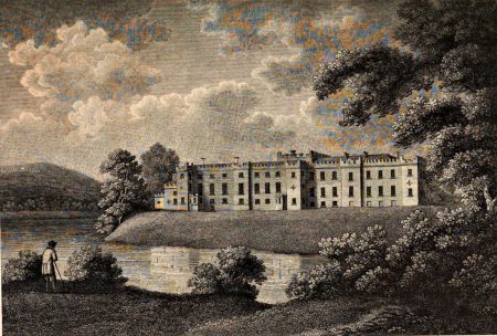
There is a description and image of the castle and its immediate surroundings (Figure 7) from Graves’ The History of Cleveland (1808, 356):
‘the present mansion…underwent a complete repair in the year 1794, when considerable additions and improvements were made to the buildings and grounds adjoining…The castle presents a long extended front to the west, situated on the brink of a small stream; which, by being collected into a reservoir, forming an extensive sheet of water, with sloping banks, adds greatly to the natural beauties and surrounding ornaments of the place’.
No landscape designer has been identified with certainty for these works, however it may be by Adam Mickle junior (c. 1747 – 1811). A clergyman later recalled in a letter to the author, John Walker Ord, that: ‘I well remember viewing their destruction [of Skelton Castle] with tears in my eyes. The person he employed, and urged him on to the work of destruction, was a Mr. Mickle, whom I afterwards met at Farnley Hall’ (1846, 253).
In 1804, Hall Stevenson engaged the architect Joseph Bonomi to produce further designs (RIBA 96050) but these had not been carried out by the time the architect died in 1808. His son, Ignatius, took over the commission and it was finished by 1820.
1821 – 1893Despite his large inheritance, by 1829 John Wharton was heavily in debt, which continued until his death in 1843. His nephew, John Thomas Wharton, inherited the estate and was able to restore the finances due in large part to ironstone being discovered on his land in 1850. The same year, he applied for a loan of £5,000 from the Inclosure Commissioners for England and Wales to drain lands in Skelton (London Gazette, 18 August). The first edition OS 6” map, surveyed in 1853 (Figure 8) gives the first detailed view of the designed landscape that had been largely shaped fifty years earlier.
The Skelton ironstone mine opened in 1861 and the following year, the castle moat was drained. With royalties now coming in from the mining, Wharton may have been considering work on the grounds as the landscape designer, William Brodrick Thomas, visited on the 10 Oct 1868 (Joseph W Pease diaries, private collection). He was working at nearby Hutton Hall and had previously worked at Gisborough Hall c. 1857. It appears though that he was not employed as the 1st edition OS 25” map, surveyed in 1893 (Figure 9) shows no significant changes to the designed landscape.
Later historyJohn Thomas Wharton died in 1900 and was succeeded by son, William Henry Anthony, who made some minor changes including the removal of the lodge on Guisborough Lane and its carriageway, to make the principal entrance off Marske Road. By this time, the church south of the castle had been decommissioned, enabling the area to become completely private. Further glasshouses and frames were added to the kitchen garden (Figure 10) and these can be seen in aerial photos taken in 1952 (EAW045957, https://www.britainfromabove.org.uk/en/image/EAW045957, accessed 2 February 2023).
Location
Skelton Castle is located c. 10 miles (16km) east of Middlesbrough and 3 miles (5km) northeast of Guisborough.
Area
The area covering the historic designed landscapes connected to Skelton Castle including the medieval deer parks is c. 1400 acres (560 hectares).
Boundaries
The northern and western boundaries are formed by Skelton Beck as far as South Waterfall Farm when it continues south to Old Park Farm (NZ 635 153). The southern boundary then goes eastwards from there to Margrove Park (NZ 650 157). The eastern boundary continues north from Margrove past Coombe Bank, Cripple Hill and Back Lane Farm to the entrance to the castle and old church at NZ 652 189. It then follows Marske Road north to the corn mill on the beck.
Landform
This area has a complex underlying bedrock with the northern area of the castle parkland and woodland being Staithes Sandstone Formation and the southern part being Cleveland Ironstone Formation and then Whitby Mudstone Formation to the south. The majority of the former detached parkland is Saltwick and Cloughton Formation, a mix of sandstone, siltstone and mudstone, with a further area of Whitby Mudstone Formation around Margrove Park. This is overlaid with deposits of uneven sized glacial tills giving rise to slowly permeable, seasonally wet slightly acid but base-rich loamy and clayey soils with moderate fertility. However north and south of Guisborough Lane, including the kitchen garden and in the village, the soil is a slightly acidic clayey loam with impeded drainage but moderate to high fertility.
Setting
Skelton is in the northernmost part of the Landscape Characterisation Area of the North York Moors and Cleveland Hills. This is characterised by a distinctive, steeply graded escarpment landscape forming an outward facing transition area between the moorland of the Cleveland Hills to the south and lowlands of the Cleveland Plain. The Skelton estate lies just on the boundary between these two areas, with the surrounding hills forming a spectacular ‘borrowed landscape’. Skelton Castle is on a natural promontory at 72m AOD with the land falling to the north towards Skelton Beck at 46m AOD. To the west, the parkland next to the castle rises from c. 60 OD in the north to c. 90m in the south. In the former detached parkland, the land rises steadily from c. 70m in the north to the area around Airy Hill at 205m AOD before falling again to c. 125m OD around Margrove Park.
Entrances and approaches
Entrance via Guisborough Lane onto Church LaneThis was the original entrance to both the church and to the castle and is shown on the 1722 map. 95m north of the entrance are early 19th century stone gatepiers and c. 1900 metal gates (HE Reg No. 1250450, Grade II) that mark the carriageway to the castle.
Castle Lodge (HE Reg No. 1250410, Grade II)Formerly the Gardener’s Lodge, this was designed by Ignatius Bonomi in 1811. It became the new main entrance off Marske Road in the early 20th century. Next to it are gatepiers and gates (HE Reg No. 1250411, Grade II) that date from the mid to late 19th century.
Former lodge on Guisborough LaneSituated at NZ 650 188, it was put in the late 18th or early 19th century, with the other remodelling of the estate. Soane in his Ledger B (p 122-4) on 19 February 1789 refers to ‘Lodges’ when ‘two fair designs’ were made (http://collections.soane.org/SCHEME860, consulted 3 February 2023), however there is no evidence his design was used. A carriageway then led northeast via a bridge to the castle. Both the lodge and this route were removed in the early 20th century.
Principal buildings
Skelton Castle (HE Reg No. 1262832, Grade I)Original wooden structure of late 11th century was rebuilt in stone c. 1190-1200. This structure was modified in the early 17th and early 18th centuries, with the west front being updated between 1760 and 1770, possibly to designs of John Carr. The office area was altered c. 1790-1 to designs by Sir John Soane. A more substantial remodelling took place between 1805 and 1820 to designs by Joseph Bonomi and his son, Ignatius. There were further extensions of the building in the mid to late 19th century.
Stables (HE Reg No. 1250412, Grade I)Stables and coach house c.1791 - 1800 by Sir John Soane with the stables altered and raised in 1897 to form a house.
Old Church of All Saints (HE Reg No. 1263246, Grade II*)Dating back to the medieval period, this was rebuilt in 1785. It was decommissioned when the new parish church was built in 1884-5.
Grotto (HE Reg No. 1251330, Grade II)120m northwest of the castle, this is a semi-circular building with a plastered brick roof. As it is not marked on White’s plan of 1775, it likely postdates this but the inner bricks are small and handmade of the period until c. 1785. The front of the building and lower part of the walls are made of rustic stone blocks, with some tufa stone on the outside.
Sterne’s Well (HE Reg No. 1136586, Grade II)100m southwest of Back Lane Farmhouse and 900m south of Skelton Castle is an artesian well, supplying water to Skelton Castle. The well head is listed as late 18th century.
IcehouseAdjacent to castle at NZ 65209 19331, it is accessed by a door leading to a short passage and the cone-shaped ice pit. On top it is covered by stone blocks. The bricks of the dome are of the small, handmade type of the period until c. 1785 but there are some larger, more modern bricks in the passage and around the outer door, suggesting a later remodelling.
Gardens and pleasure grounds
The medieval castle of Skelton had a ‘little park’, possibly to the west, north and northeast, in the area covering the current parkland and woodland. Evidence from other sites suggest that these were pleasure grounds, designed to be viewed from the castle and could include cultivated or garden areas, orchards, fishponds and grassed parts (‘lawns’) for grazing horses and other domestic animals (Creighton 2009, 133-8). They were usually fenced off from the neighbouring, larger parks that held deer and had rabbit warrens.
In 1584, there is reference to the ‘high lawn’ as far as ‘the pale [boundary] of the Howell of Hay’ as well as ‘Coneygarth birks [birches] & launds with the orchard’ of 10a, which was probably part of this ‘little park’ (NYCRO ZLQ 73). Next to the castle on the west, there is a reference to a ‘garden place adjoining’ that may possibly be the area shown on the 1722 map that was later terraced. By the early 18th century, there were garden areas to the north, east and west surrounded by walls or other enclosures. With the exception of the southeast portion, most of these had been removed by 1773. With the addition of the new kitchen garden to the southeast sometime after 1775, this too was taken out and replaced by pleasure grounds. By the mid-19th century, there was a small garden area immediately south of the castle of trees and shrubs and shown in Atkinson 1877 (Figure 11). To the north of the walled kitchen garden, where an orchard had been proposed by White, a small garden was created by the 1850s overlooking the fishpond.
Kitchen garden
The first known kitchen garden was southeast of the castle next to the carriageway from the south and is shown on the 1773 estate map (Figure 5). Following White’s improvement plan of 1775, a new one, covering 2¾ acres, was built next to Marske Road in the position he indicated, possibly c. 1778 when Hall Stevenson noted significant expenditure on labourers. The extant brickwork of the external walls and also the majority of the inner wall are of the small handmade type typically made before 1784. The northern wall and possibly the middle wall and southern wall had fireplaces at the back, suggesting that they were ‘hot walls’. The 1st edition OS map (Figure 12) shows the characteristic sheds that housed the fireplaces on the middle and southern walls, while the northern wall still has the bricked-up fireplaces in evidence.
By the mid-1850s, it had expanded to the south to cover just under 4½ acres, with the new section being an orchard (Figure 12). The hot walls along the middle section were replaced by a glasshouse and boiler shed behind by 1893, together with two small glasshouses in the northeast corner and some frames just outside the walled area (Figure 9). Further freestanding glasshouses and frames were added between 1893 and 1909 (Figure 10). Two of these that are still extant were built by Foster and Pearson of Beeston, whose 1909 catalogue name W. H. A. Wharton as a client. They also supplied one of their ‘Robin Hood boilers’ that was located in the northeast corner with underground pipework to the glasshouses.
Wharton was also recorded by Richardsons & Co. of Darlington as a client in a sales brochure from the early 20th century. That may relate to the extended central glasshouse or the additional frames in the former orchard area to the southeast. One of the new glasshouses was used for growing carnations, possibly the ‘perpetual’ or greenhouse type that had been introduced from America in the 1890s (Cook 1912, 4). A hardy border type called ‘Mrs Wharton’, bred by Skelton’s gardener, Joseph Richard Batty, was given the RHS Award of Merit in 1911 (RHS 1911/2, 146).
Park and plantations
Haia, Asadale and chace of WestwithThe ‘haia’ or hay was an area that was enclosed when the original castle was built in the late 11th century, as it is mentioned in documents of the foundation of Gisborough Priory in 1119. It may have extended from the castle in the east to Skelton Beck in the west, as the name persists in ‘How La Lay’ farm at NZ 636 180 and to Rawcliff Banks in the south at NZ 641 165, giving an area of c. 1500 acres.
Asadale, which was part of Skelton forest, became a hunting area in the 13th century and one of its boundaries was at ‘Aysdale Gate’ (NZ 652 147). The ‘chace’ or chase of Westwith was likely to be around the later ‘Westworth Farm’ (NZ 637 140).
Westpark/Skelton ParkThis was one of the parks of the ‘hay’ recorded in 1305. A sketch map of the late 16th century states that the total area is 695½ acres and split as follows (NYCRO ZLQ 73):
The hia lawn containing 184a 1r
The middle part containing 240a
Richard Horners part containing 27a 2r
The lowe part containing 243a 3r
By 1584, it had reduced to just over 601a and the following year was divided into 2 equal parts with a northern part and a southern part to ‘Lamb hagg’. This would have included the later parks of the 18th century, the area southwest of the castle including ‘Bowman Hill’ (NZ 648 148) and ‘Great Lawn’ and the area to the west with ‘Duck Hill’ (Figure 1). On the 1722 map, there is a tower depicted in the latter area, called ‘Stewards Tower’. Hunting lodges were often built as a tower to allow an upper viewing area for the owner and their guests. It could also have served as a banqueting house. These structures continued to be built in parkland well into the 17th century (Girouard 1978, 76-7), so may have been a post-medieval feature.
Maugrey or Margrove ParkIt is first mentioned in the mid-14th century. In 1408 Joan, widow of Thomas Fauconberg, was granted in her assignment of dower, ‘in a place called the Launde of Maugrepark one vesture of 14 acres to the south worth 18d. an acre and 2¾ acres of the covert there to the west, worth 16d. an acre’ (YAS 1918, 70). It may well have extended into neighbouring Guisborough. Rimington (1975, 11) observed that ‘there is a fairly well-preserved pale wall and ditch…running from South Waterfall Farm on the main road…to Old Park Farm where it forms part of the outbuildings. The ditch then proceeds uphill in the direction of Aysdale Gate, where it is lost in the Forestry plantations. There are the remains of a very old wall on a bank halfway up Spring Bank Wood to the north of Margrove Park House, which could well be the northern pale.’ These possible boundaries are shown on Figure 2 and would give an area of c. 500 acres.
The 1584 survey (NYCRO ZLQ 73) said that the part in the Skelton estate contained just over 354 acres. The following year it was divided into three:
The lodge hagg and west end of Margrove Park beginning at the end towards Guisborough and southwards – 181a
The east of Margrove park beginning where the manor doth leave in the park aforesaid square down as the measure will stretch to – 37a
All the domain of Margrove park which lies in the east towards the wood…stretching…between Stanghow and Aysdale [wood] – 136a
The latter part also had 171a of the Asadale wood grounds adjoining it.
While John Jackson is recorded living there in 1586, it may have ceased to be a park at this stage or soon after. John Atherton, who had married Katherine Conyers, started alum mining in 1603 and prepared to build a manufacturing house in Spring Bank on the northern edge of Margrove Park (Turton 1938, 66). On 10 November 1606, John and Katherine Atherton leased three closes in Spring Bank to John Bourchier for 21 years to continue mining, one of which was called ‘Lodge Hagg’ (ibid, 68). This may have been where the park lodge was situated as ‘hagg’ means an area where trees have been cleared.
Low Park & High ParkBy the early 18th century, much of the former parks had been converted into farmland. However, a section had been retained as a park and split into two areas: ‘Low Park’ to the north and ‘High Park’ to the south (Figure 13). Their combined area covered c. 190 acres and each was surrounded by a wall or other physical boundary. On the earlier estate map of 1722, a park lodge was marked at approximately NZ 640 181 in Low Park and the 16th century ‘Birk House’ at NZ 645 173, just outside the park boundary. By 1853, the former had been demolished and only a ruin remained of the latter. The area was leased for mining in 1868, with production starting a few years later.
Skelton Castle parklandOriginally part of the medieval ‘Little Park’, the parkland to the west of the castle known as ‘Lawns’ covers just under 62 acres and was probably created in the late 1790s.
Spring Wood & Spring Bank WoodThe part to the east of the castle dates to at least the early part of the 18th century. This had been extended by 1773 and again north and westwards in the early 19th century to cover the fields known as Spring Bank.
Waller Gill Wood/Crow WoodSouth of the castle, this dates from at least the early 18th century.
Stocking WoodNorthwest of the castle, this dates from at least the early 18th century.
Water
MoatCreated in the 1790s where the castle’s original defensive ditch had been. In 1862, the retaining dam was removed and so the area became dry.
FishpondCreated in the 1790s, a new dam was added in 1862 when the larger area of water (‘Moat’) was removed.
Books and articles
Cook, L. J. 1912. Perpetual carnations; a complete manual, with all details of cultivation. London, Cassell.
Creighton, O.H. 2009. Designs Upon the Land: Elite Landscapes of the Middle Ages. Woodbridge, The Boydell Press.
Girouard, M. 1987. Life in the English country house: a social and architectural history. New Haven, Yale University Press.
Graves, J. 1808. The History of Cleveland, in the North Riding of the County of York. Carlisle, F. Jollie and Sons.
Hall, I. 1979. Samuel Buck’s Yorkshire Sketchbook. Wakefield, Wakefield Historical Publications.
I’Anson, W. M. 1913. ‘The Castles of the North Riding’. Yorkshire Archaeological Journal 22, 303-99.
Nichols, J. G, 1853. The Topographer and Genealogist Vol 2. London, John Bowyer Nichols and Sons.
Ord, J. W. 1846. The History and Antiquities of Cleveland. London, Simpkin and Marshall.
PRO 1898. Calendar of Inquisitions Post Mortem, Volume 1, Henry VII. London, HMSO.
PRO 1900. Calendar of the Close rolls, Edward I 1272-9. London, HMSO.
PRO 1903. Calendar of the Charter rolls, Volume 1, Henry III 1226-57. London, HMSO.
PRO 1904. Calendar of inquisitions post mortem, Volume 1, Henry III 1236-72. London, HMSO.
PRO 1910. Calendar of the Close rolls, Edward III 1364-8. London, HMSO.
PRO 1916. Calendar of inquisitions post mortem, Volume 9, Edward III 1347-52. London, HMSO.
PRO 1935. Calendar of inquisitions post mortem, Volume 11, Edward III 1361-5. London, HMSO.
Rimington, F. C. 1975. ‘The Early Deer Parks of North-East Yorkshire, Part II’. Transactions of the Scarborough Archaeological and Historical Society 18, 9-13.
RHS 1911/2. Journal of the Royal Horticultural Society of London, Volume 37.
Surtees Society 1889. Cartularium Prioratus de Gyseburne, Volume 86. Durham, Andrews & Co.
Turnbull, D. and Wickham, L. 2022. Thomas White: redesigning the northern British Landscape. Oxford, Windgather Press.
Turton, R. B. 1938. The alum farm: together with a history of the origin, development, and eventual decline of the alum trade in north-east Yorkshire. Whitby, Horne & Son.
Warburton, J. 1900. ‘Journal in 1718-9 of John Warburton, F. R. S., F. S. A., Somerset Herald’. Yorkshire Archaeological Journal 15, 61-84.
YAS 1888. Feet of fines of the Tudor period, Part II, 1571-82, YAS Record Series 5. Leeds, Yorkshire Archaeological Society.
YAS 1892. Yorkshire Inquisitions of Edward I, Volume 1, YAS Record Series 12. Leeds, Yorkshire Archaeological Society.
YAS 1897. Index of wills in the York Registry, 1585 to 1594, YAS Record Series 22. Leeds, Yorkshire Archaeological Society.
YAS 1917. Yorkshire Fines for the Stuart period, Volume 2, James I, 1614-1625, Record Series 58. Leeds, Yorkshire Archaeological Society.
YAS 1918. Inquisitions Post Mortem relating to Yorkshire of the reigns of Henry IV and Henry V, Record Series 59. Leeds, Yorkshire Archaeological Society.
Primary sources
North Yorkshire County Record Office (NYCRO)ZLQ 73 Surveys of Skelton and Brotton estate 1584/5; sketch map of Skelton park, nd (late 16th century); contract for sale of wood, 1648
Private CollectionMap of the Skelton Castle estate, 1722
Map of the Skelton Castle estate, 1773
A Plan of Alterations designed for Skelton Castle the seat of Hall Stevenson Esq. by Thomas White, 1775
Royal Institute of British Architects Archive (RIBA)96050 Unexecuted design for alterations and additions to Skelton Castle: perspective from the south-east by Joseph Bonomi, 1804
Soane Museum (SM)SM 64/4/62-4 Drawings of stables by Sir John Soane for Skelton Castle, 1790-1
SM 30/1A/1-5 Drawings of alterations to offices by Sir John Soane for Skelton Castle, 1790-1
Maps
Ordnance Survey 6” 1st edition, surveyed 1853, published 1856
Ordnance Survey 25” 1st edition, surveyed 1893, published 1894
Ordnance Survey 6” revised 1913, published 1920
Figure 1 – Possible location and boundaries of medieval deer park known as Wes[t]park on the revised edition of the 6” OS map, published 1920. National Library of Scotland. CC-BY.
Figure 2 – Possible location and boundaries of medieval deer park known as Margrove [Maugrey] Park on the revised edition of the 6” OS map, published 1920. National Library of Scotland. CC-BY.
Figure 3 - Drawing of Skelton Castle from Hall-Stevenson, J. (1780). Crazy tales: and Fables for grown gentlemen. A new ed., London: Printed for J. Dodsley. University of Michigan Library, public domain - https://catalog.hathitrust.org/Record/000123248/Home
Figure 4 – Skelton Castle, gardens and immediate grounds from estate map of 1722 (private collection).
Figure 5 – Skelton Castle (marked 1), terracing and gardens (2) from estate map of 1773 (private collection).
Figure 6 - Plan for the improvement of Skelton Castle by Thomas White, 1775. Private collection.
Figure 7 – Drawing of Skelton Castle and moat from Graves, J. 1808. The History of Cleveland, in the North Riding of the County of York. Carlisle, F. Jollie and Sons. Original from New York Public Library and digitised by Google - https://catalog.hathitrust.org/Record/000109688/Home
Figure 8 – Remodelled landscape around Skelton Castle from OS 6” 1st edition map, surveyed 1853 and published 1856. National Library of Scotland. CC-BY.
Figure 9 – Detail of drained moat, fishpond and kitchen garden from OS 25” 1st edition map, surveyed 1893 and published 1894. National Library of Scotland. CC-BY.
Figure 10 – New entrance off Marske Road and new glasshouses in kitchen garden from OS 25” 1st edition map, revised 1913 and published 1914-5. National Library of Scotland. CC-BY.
Figure 11 – south front and gatehouse of Skelton castle with small shrubbery in front from Atkinson, J. C. 1872-77. The History of Cleveland, ancient and modern, Volumes 1 & 2. J. Richardson, Barrow-in-Furness. British Library, public domain.
Figure 12 – Detail of kitchen garden from OS 6” 1st edition map, surveyed 1853 and published 1856. National Library of Scotland. CC-BY.
Figure 13 – Skelton ‘Low Park’ and ‘High Park’ from OS 6” 1st edition map, surveyed 1853 and published 1856. National Library of Scotland. CC-BY.


