During the second half of the 18th century, Welton and other villages west of Hull became favoured spots for successful Hull merchants to acquire land and build estates for themselves. One of the first of these was James Shaw, who built Welton House on a raised piece of ground just east of the village from around 1748. He acquired further land around it and by his death in 1768, had created a small designed landscape. It was inherited by his wife’s nephew, Thomas Williamson, another Hull merchant, who continued to develop the area around Welton House, engaging the services of the noted landscape designer, Thomas White, in 1769.
Following the enclosure of Welton’s remaining open fields in 1775 Williamson and his brother in neighbouring Melton, started landscaping large sections of the area including 160 acres in Welton Dale to the north. By 1793, Welton was described as ‘an extended range of pleasure grounds’ and a resident’s building there being ‘surrounded by the Arcadian walks, woods, and lawns, of her wealthy neighbours, to which she has constant access’ (Seward 1811, 270-1).
Williamson’s daughter and son-in-law, Anne and Robert Raikes, also had ambitious plans when they took possession in 1809, creating new pleasure grounds and the kitchen garden complex between Welton House and the village. They too acquired more land at Welton including other ‘mini estates’ around their lands. However the Raikes family were forced to sell after the death of Anne Raikes in 1848 to pay off large debts incurred. The new owners, the Broadley family, also had made their money from trade in Hull and with large resources continued to buy up land at Welton until by 1886, they owned nearly all of it.
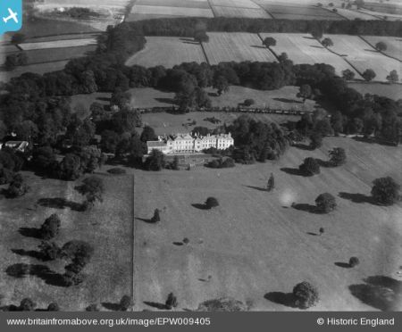
The designed landscape reached its peak by the start of the First World War. It became too expensive though to maintain and the estate was sold off in the early 1950s. Welton House itself was demolished in 1952 with many of its associated buildings also removed to make way for housing. Only a small part of the parkland remains but two important areas created by Thomas Williamson, Bow Plantation and Welton Dale, remain and are enjoyed by visitors as part of the Yorkshire Wolds Way, a national trail.
Estate owners
On his death in 1768, James Shaw left Welton House and lands in Welton that he had acquired to his wife’s nephew, Thomas Williamson. Thomas’s daughter, Anne, married Robert Raikes and they inherited on her father’s death in 1809. Anne died in 1848 and the property was sold to Henry Broadley. His sister, Sophia Broadley, was the next owner from 1851 as Henry was unmarried at his death. She too remained single and so the Welton House estate devolved to her nephew, William Henry Harrison (later Harrison-Broadley) in 1864. It then passed to Henry Harrison-Broadley, William’s nephew, in 1896 and remained with the Harrison-Broadley family until the early 1950s when the land was sold for development.
Key owners responsible for major developments of the designed landscape and dates of their involvement:
James Shaw c. 1748 – 68
Thomas Williamson 1768 – 1809
Robert and Anne Raikes (née Williamson) 1809 – 48
Sophia Broadley 1851 – 64
William H. Harrison (later Harrison-Broadley) 1864 – 96
Henry B. Harrison-Broadley 1896 - 1914
Early history of the site
Welton was part of the manor of Howden that had been granted to the Bishops of Durham in the late 11th century, which together with Melton covered about 2,400 acres. By the mid-18th century, just over 260 acres were enclosed in Welton, with the remaining 1,472 acres open fields and meadows. The first enclosure act of 1751 covered a further 382 acres and by 1775, the entire township had been divided up amongst numerous owners. The largest of these was Thomas Williamson’s landowning that covered c. 760 acres. He had inherited both the lands and Welton House from his uncle, James Shaw, in 1768.
James Shaw was a Hull merchant who had married Dinah Mould (Mowld) in 1737. She was the daughter of James Mould, another Hull merchant, and sister of Mary who married Joseph Williamson, father of Thomas. It is not clear when or how Shaw acquired the land at Welton, however by 1748, the Poor Rate book for Welton showed he had land there (ERALS DDX1616/1). This book starting from 1748 (ibid) gives some indication of the changes in Shaw’s land and property, with the requirement to contribute usually ½d for each £ of value of property for the benefit of the poor of the parish. In the first entry, he paid 3½d, probably for his residence and immediate grounds that would value them at £7. He also had land valued at £25 in his own hand (i.e. untenanted) and another piece of ground tenanted by William Lowthrop worth £12 10s (ibid).
Shaw was mentioned in a writ regarding a road in Welton between June 1748 and May 1749 (TNA C202/137/1) and it may have been related to expanding his residence, as this was valued at £10 the following year in the Poor Rate book (ERALS DDX1616/1). Following the first enclosure of 1751, he continued to increase his landholding in and around Welton House with Clayhill Close added by 23 April 1753, Ladywell Close and Hall Flatt Closes by 31 March 1755 and Creke Lane Close by 19 April 1756 (ibid). By 12 April 1762, Westoby Close was included. In 1766, the lands where he was listed as the owner were (ibid):
James Shaw Esq for Hall [homestead and Clay Close, in hand] – 5d
Ditto for crofts and orchard [in hand, added in 1764] – 6d
Ditto for his Ladywell Close and Common Closes [in hand] – 3½d
Ditto for his two Hall Flatt Closes [in hand] – 2¾d
Thomas Spicer for Mr Shaw Crake Lane - 2¼d
Thomas Spicer for Mr Shaw [Farm] – 1s 8d
Wm Lowthorp for Mr Shaw Land [Farm] & corn house - 1s 10½d
Widow Woodcroft for Mr Shaw Close – 4d
Watson Stickney for Mr Shaw Close - 3½d
Robert Gill for Mr Shaw Close - 2d
The lands above were unchanged when Shaw died in 1768, with the estate passing to Thomas Williamson described as: ‘6 messuages, 3 cottages, 30ac.3p. demesne, 33 oxgangs, 19ac. inclosed land (part of the said oxgangs) and 192ac.2r.9p. Forby land’ (ERALS DDHB/52/3). From the markings of the old boundaries on the White plan of 1769 (ERALS DDTH 68i), the designed landscape created by Shaw may be reconstructed (Figure 1). Most noticeable are the two areas to the south of Welton House that are possibly formal garden areas typical of the first half of the 18th century. The adjacent kitchen garden areas (orchard) were probably in place by 1764, as were the stables just to the north by 1768. The 30 acres of demesne land included the open areas to the north (Great Crofts, Hall Flatts Close and Ladywell Closes) and south (Clayhill), which may have been small areas of proto-parkland.
Chronological history of the designed landscape
1768 – 1809In 1769, Williamson called in the landscape designer, Thomas White, to redesign his newly acquired property. The extant plan (ERALS DDTH 68i, Figure 2) is restricted to the area that Shaw had taken in hand around Welton House with the exception of Crake Lane Close to the south of Crake Lane. White’s plan is quite modest with the removal of the field boundaries and Crake Lane in the south to make them into two sections of open parkland. A continuous shelterbelt around the perimeters was proposed with a carriageway or path running through them. Seats at the extreme southwestern and northeastern points in the southern section and at the northeastern point in the northern section were designed to afford a view back to Welton House.
While the enclosure map of 1772 (ERALS DDTH 68ii, Figure 3) showed that Williamson owned nearly all these areas, it is clear that the plan had not been fully implemented by then as Crake Lane to the south was still in place and a small strip (‘Sissons Land’) of ¼ acre divided the proposed northern parkland. While the design for the northern parkland with its perimeter boundary plantations was put in place, it is not clear from later map evidence (Figures 4 and 5) whether the southern parkland had the proposed boundary plantations. Williamson did though acquire land adjoining Crake Lane in 1787/8 (ERALS DDHB/52/564, /566 & /567) that he did not own, which allowed him to close the lane under the terms of the enclosure act (Thompson 1870, 67).
In the enclosure completed in 1775, Williamson gained large sections to the north including the part south of Strousdale Road (later Bow Lane) and Stone Pitt Field next to Waudby. Later maps show that these became part of a much wider designed landscape (Figure 4). The former was included in the northern parkland with the ‘Bow Plantation’ running along its western and northern perimeter until it reached the boundary with Melton and the ‘Terrace Plantation’ belonging to his brother’s estate of Melton Hill. A description from the 30 July 1796 noted (Rutland 1813, 51):
‘For two hours we walked round the extensive and charming grounds of Mr. Williamson. Since he first came to Welton (about 24 years since), he has planted 200 acres; but with such taste and judgment, that he has an extent of rides, walks, and drives, through the grounds so planted, for at least seven or eight miles. His brother has a seat adjoining, and their plantations uniting, mutually assist and embellish each other. After a walk of some length, enlivened by an occasional view amongst the mountain-ashes, the oaks, and the firs that encompassed us, we arrived at the top of a hill which extended nearly a mile [Bow Plantation]. Below it wound a pleasant turf drive, from which, on the opposite side, rose a corresponding hill, covered with plantations [Terrace Plantation] which skirted its declivities.’
Williamson though had a more ambitious scheme for the area later called ‘Welton Dale’ to the northwest. Covering about 160 acres, it took advantage of a natural valley either side of a small stream from the village mill pond in the south to the boundary of Wauldby in the north. Plantations were added on either side and the former public road to Beverley was moved to the west with the enclosure act (Thompson 1870, 67). In 1780, he acquired the manor of Wauldby that included Wauldby Wood and the Pale Walk for £10,000 on 22/23 September (ERALS DDHB/57/295). The Duke of Rutland also visited this in 1796 (1813, 52):
[we] proceeded…to see a prospect of much fame, at a distance of two miles. Our route lay through a long line of plantations [Dale Plantation], so managed as to admit, every now and then, a view of the surrounding scenery, the leading feature of which was the grand estuary formed by the union of the Trent and Ouse. At length we arrived at a neat farm-house [Welton Wold Farm], surrounded by plantations, and seated on the brow of a very steep hill; from the foot of which a most fertile and extensive vale spread as far as the eye can scan. We ascended several staircases, to a turret which Mr. Williamson has built, in order to reap the full benefit of the prospect.
By 1794, Williamson owned 762a 3r 8p in Welton and this increased to 769a 3r 18p by 1805 (ERALS PE106/25). Thompson (1870, 71) states that Williamson moved the public road from Welton to Melton to the north away from Welton House c. 1800, however no evidence has been found for this and it may have been done by his successor when building the stables and lodges c. 1810.
1809 – 1848On inheriting the estate, Robert and Anne Raikes began to buy up neighbouring land to expand the grounds of Welton House. Their first acquisition c. 1810 was the property of Joseph Thompson between the house and the village to enable the expansion of the pleasure grounds and flower garden (Thompson 1870, 71). The house occupied by William Paine (estate steward) was also removed to build the stables about the same time (ibid). Further purchases were made in the area such as the one in 1821, when the garden of Mrs Ann Cornwell was bought from Jarvis and Thomas Empson (DA DXBAX 62069). These acquisitions also enabled a new kitchen garden to be built to the southwest and a hothouse and greenhouse in the northwest corner next to the village (Figure 6).
The parkland was enlarged to the east with the addition of the fields belonging to R and J Johnson in 1772 that were next to the later East Dale estate by 1824 (Figure 4). As the public road had been moved north, two lodges were added at the east and west points where the old and new road met. The Raikes also acquired other ‘mini’ estates that had developed on the western side of the village after the enclosure including Welton Grange from the Carricks Trustees c. 1835 and Welton Hall. To the east between Welton House and Melton was the East Dale estate that had been developed by Benjamin Blaydes Thompson in the late 18th century. This too was bought by the Raikes family before 1837. A plan from c. 1834-7 (HHC UDDCV/177/5) shows the expanded family holdings as well as the addition of an area of parkland south of Pool Bank (private) road of just over 30 acres.
During their tenure, the Raikes continued to develop the designed landscape at Welton Dale, most notably adding the Mausoleum at the northern end in 1818. It was consecrated in 1822 when a public burial site was put next to it (Beverley and East Riding Record, 28 February 1863). This and other ‘walks’ on the estate were open to members of the public, who were deemed ‘respectable’ and given a key to various gates to gain access (Neave and Turnbull 1992, 75). The area north of Welton House was named ‘Temple Walk’, although when the building known as the Temple was constructed is uncertain. A book published in 1841, describes it as a ‘neat temple, painted green, with fluted pillars, and surmounted with a Chinese top’ (ibid).
These acquisitions and developments though came at a cost and the estates at Welton were charged with a mortgage of £70,000 (DA DXBAX 62069). By 23 November 1847, Robert and Thomas Raikes (sons of Robert and Anne) had made an agreement to sell the majority of their estates to Henry Broadley for £170,000 after the demise of their mother to clear the mortgage (ERALS DDHB/52/36). Broadley had also acquired Melton Hill, previously the home of Joseph Williamson, Thomas’ brother.
1849 - 1896The transfer of the Welton properties held by the Raikes family (with the exception of East Dale House and lands) to Henry Broadley was completed on the 5 April 1849 (ERALS DDTH/29). Broadley died two years later and his estates were inherited by his sister, Sophia. She followed the example of the previous owners and bought up neighbouring properties, the first being Welton Garth in 1858. This had been the property of John Smith and parts of it were adjacent to the walled kitchen garden (Figure 7). She next acquired East Dale from the Raikes family in 1862, demolished the house and associated buildings soon after (Thompson 1870, 77). The former gardens of East Dale were replaced with plantations as an extension to those on the east side of the Welton House estate (Figure 7).
Sophia Broadley made changes to Welton House and its immediate grounds, adding the conservatory to the west, a raised terrace to the south and increased the pleasure grounds from the stables to the walled kitchen garden between 1852 and 1854 (ERALS DDTH/68iv). She may also have removed the Chinese style temple around this time as it is not shown on any further maps.
With Sophia Broadley’s death in 1864, her nephew, Colonel William Harrison (later Harrison-Broadley), inherited her now extensive estate at Welton and neighbouring Wauldby. This can be seen in an estate map of 1870 (HHC C DBHT/8/180), where he owned the majority of the land at Welton. The only other major landowners were the Vicar of Welton who had c. 300 acres just south of Welton Dale and the late Mrs Gallard with c. 70 acres, as part of the Welton Hill estate. The latter was bought by Broadley in 1889 from the Gallard family.
Colonel Harrison-Broadley increased the number of glasshouses in the walled kitchen garden and many unusual plants were grown on the estate by his gardener, Charles Lawton, who was employed from 1870. An article from 26 July 1890 (The Gardeners’ Chronicle) described the pleasure grounds with tender plants
Later history‘many of which have figured with great credit at northern exhibitions. Specimens of Gleichenia dicarpia ranged from 3 to 8 feet high…G. speluncae was 4 feet in diameter; G. Mendelii, 5 feet. Among the many plants in bloom were noticed Franciscea Lindleiana, very fine Statice profusa, Erica Cavendishii…E. Paxtoni and E. tricolor…Cypripedium venustum…and Indian Azaleas…A fine plant of Ouvirandra fenestralis’.
Colonel Harrison-Broadley died on 28th March 1896 and was succeeded by his nephew, Henry Harrison-Broadley. The latter immediately made changes to Welton House extending the east wing (Daily Mail, 25 August 1896) and to the grounds, making a sunken lawn to the north of the house and expanding the pleasure grounds to the west. He also added a new entrance just northeast of Welton House with a carriageway joining up with the one from Melton Lodge further east and put additional glasshouses in the walled kitchen garden (Figure 8).
In February and March of 1897, the nurseryman, John Proudlock of nearby Market Weighton, supplied 41,200 trees and shrubs that were to be planted in Welton Dale (HHC C DBHT/5/153). The second edition 6” OS map, revised in 1908, shows the areas that had been planted since 1888 (Figure 9) including 20.768a next to the Dale Plantation, 3.531a in the ‘Pheasantry’, 3.625a next to the Welton Wold Plantation and about 2.5a in 4 sections in the eastern side of the valley. The trees and shrubs supplied were (ibid):
28,000 Larch fir
3,600 Spruce fir
2, 600 Scotch fir
1,600 Austrian pines
6,000 Evergreen privet bush
1,000 Berberis Aginfolia [Berberis aquifolium]
Henry Harrison-Broadley died on 29 December 1914 and his descendants continued to own the property, although by the late 1930s, his family preferred to live at their other nearby estate, Tickton Grange. By 1952, the estate had been sold off by the family and Welton House demolished. Its site together with the pleasure grounds, northern parkland and the walled kitchen garden were subsequently built on by housing (Figure 10). The A63 road now runs through the lower part of the southern parkland.
Location
The Welton House estate lies 8 miles (13km) west of Kingston-upon-Hull.
Area
The historic designed landscape of Welton House and the adjoining Welton Dale covered c. 380 acres (154 hectares).
Boundaries
The northern boundary of Welton Dale is formed by the northern extent of the plantation next to Wauldby from SE 964 291 until SE 972 291. Its western boundary is marked by the road from Welton to Wauldby, with the exception of the area known as ‘The Pheasantry’ when it abuts Lings Plantation. Its southern extent is Welton Springs and the Spring Plantation in the west to SE 964 276 in the east, just next to the Bow Plantation. Its eastern boundary is the edge of the Welton Dale plantation.
The northern boundary of the wider Welton House estate is formed by the Bow Road from Welton to Melton until it reaches the edge of the Terrace Plantation at Melton. Its western boundary follows Crossall Hill Lane from top of the Bow Plantation to the northern edge of Temple Walk and the northern parkland. The latter continues to its easterly point at SE 965 272 and then to the road to Melton.
The western boundary of the main designed landscape follows the edge of the pleasure grounds next to the village until it reaches the walled kitchen garden and Poolbank Lane. The latter forms the southern extent until SE 960 268 when it gets to the southern parkland extension and goes from SE 958 264 to SE 961 263 before rejoining Poolbank Lane. At the junction with Low Field Lane, the southern boundary continues eastwards until Green Lane, which is the eastern extent of the southern parkland. The northern boundary follows the road from Melton to until it reaches the southern extent of the Temple Walk.
Landform
The underlying geology of Welton House’s designed landscape is Ancholme Group - Mudstone. This is overlain with sedimentary superficial deposits of clay, silt, sand and gravel that gives rise to freely draining lime-rich loamy soils and moderate fertility at the site of Welton House estate. In Welton Dale, the underlying geology is Ferriby Chalk in the valley bottom and Welton Chalk on the hillsides. This is overlain again with sedimentary superficial deposits of clay, silt, sand and gravel that gives rise to soils that are shallow lime-rich.
Setting
Welton House park and garden is in the East Riding Local Landscape Character Area of ‘Elloughton cum Brough to Hessle Urban Edge Farmland’. This is defined by its open views to the river in an area that was predominantly rural but now with the extensive housing, so green space is limited to recreational land use. The north and west part of the old Welton village has a larger than average green space, so this was defined as a conservation area. However the site of the Welton House estate is not included in this.
The former Welton House itself lay at 35m AOD with the designed landscape to the north (Bow Plantation) rising to a height of between 46m to 79m OD. To the south and east of the house, the land falls away to between 21m to 11m OD. To the west, the land also declines to between 29m and 22m OD. Welton Dale rises from 49m AOD in the south to 121m AOD in the north, with the valley bottom c. 20m from the hilltop on either side.
Entrances and approaches
Welton LodgeMain entrance from Welton village, Welton Lodge was built in the 1810s and is extant, together with part of the boundary entrance wall. The carriageway then went east to the northern front of Welton House.
Melton LodgeEntrance from Melton and the east, Melton Lodge was a pair of small buildings built probably by 1837. They were demolished for housing by the late 1960s. The carriageway then went west to the northern front of Welton House.
Entrance off Welton-Melton roadThis was added between 1888 and 1908 just northwest of the hall (SE 964 271) to enable a shorter access to the eastern carriageway to Welton House.
Principal buildings
Welton HouseFirst built probably in the 1740s, it was subsequently enlarged by its later owners to reach its greatest extent by 1900. It was demolished in 1952 following the sale of the wider estate.
StablesBuilt in the 1810s between Welton House and Welton Lodge, it replaced an earlier stable block just northeast of Welton House shown on the 1769 plan by White. It was demolished by the late 1960s for housing.
IcehouseIts date of construction is unknown but first appears on the 1st edition OS map, surveyed in 1852. It was located at the northeast corner of Temple Walk at SE 961 273.
Welton Dale CottageBuilt c. 1870 to 1888 next to Welton Springs at SE 962 279, it was the visitor entrance to Welton Dale.
Gardens and pleasure grounds
The first gardens were probably laid out with the construction of Welton House in the 1740s. From the White improvement plan (Figure 1), these were to the south of the building and appeared to be two formal areas with a path in the middle. Whether Williamson followed White’s advice to remove these and replace with open parkland is not known, as no maps survive from this period that show detail of the gardens.
With the construction of the new stables and walled kitchen garden by 1824, the area between the stables and Welton House was developed as pleasure grounds (Figure 5). This was significantly expanded by Sophia Broadley between 1852 and 1854 between the stables and the kitchen garden (ERALS DDTH/68iv). She also added a terraced garden in front of the south façade of Welton House (ibid). Further changes were made between 1896 and 1908 when Henry Harrison-Broadley straightened the fence or haha between the pleasure grounds and the parkland, incorporating more of the latter into the former (Figure 8). He also added a sunken lawn to the north of Welton House and planted two avenues of conifers either side of it.
Kitchen garden
The kitchen garden shown in White’s plan next to Welton House was probably built in 1764 as this is when the adjacent orchard is first mentioned in the poor rate book. This was removed by Robert and Anne Raikes soon after they inherited the estate in 1809. The new walled kitchen garden was built before 1824 to the southwest next to the village. With its attached orchard, it covered just over 3 acres. In addition, a hothouse and greenhouse were built in the northwest part of the pleasure grounds, again next to the village. The date of these is unknown but were in place by 1852 (Figure 5). In the main kitchen garden, there were further glasshouses including one attached to the central wall and another on the northern wall.
By 1888, more glasshouses had been added in the kitchen garden with the range on the southern side of the middle wall extended and a new one on the northern side that was possibly a fernery, given reports of other tender ferns grown on the estate (The Gardeners’ Chronicle, 26 July 1890). In the northwest section, there was a large freestanding glasshouse with two smaller glazed structures that possibly were frames. There was also a freestanding glasshouse to the south of the large range in the middle (Figure 7). By 1908, two glasshouses and two possible frames had been added to the northeast section (Figure 8). By the late 1960s, the walls and two of the glasshouses remained but these were removed later for housing (Figure 10).
Park and plantations
‘The Lawn’ [southern parkland]James Shaw had possibly created a small area of proto-parkland to the south and southwest of Welton House in the closes called ‘Clay hill’ and ‘Westoby’s Home’ covering about 10 acres (Figure 1). During Thomas Williamson’s tenure, the parkland possibly included the c. 4 acres of the formal gardens and the area below Crayke Lane (c. 8 acres) if he followed White’s plan. By 1824, the parkland had been expanded to the east and west and now was just under 57 acres. It later included a further 30 acres south of Pool Beck Lane and 47 acres between Low Field Lane and Green Lane.
Northern parklandThis was part of White’s plan and was probably carried out by Williamson by 1796 (Rutland 1813, 51). It covered about 17 acres. When the public road was moved north, it was split in two and the lower half of c. 6 acres became pleasure grounds in the 1900s.
Temple WalkA similar plantation is shown on White’s plan and so it is likely that Williamson implemented this. Extending to five acres, it is now largely built over.
Bow PlantationExtant by 1796 (Rutland 1813, 51), it was designed to connect with his brother’s Terrace Plantation at Melton. Covering nearly 22 acres, it still exists as a woodland and is on the route of the Yorkshire Wolds Way.
Welton DaleCreated between 1772 and 1780, its 150 acres was planted either side of the valley with further trees added in 1897. A shelterbelt was put around Welton Wold Farm, where visitors went in the late 18th century to admire the view (Rutland 1813, 52). In the late 19th century, a lodge was added near at the southern entrance to admit visitors. It is still extant as a woodland and is on the route of the Yorkshire Wolds Way.
Water
A small pond (0.187 acre) is located in the southern parkland next to Poolbank lane. It was created by damming Pool Beck and probably created in the late 18th century to aid drainage in the parkland.
Books and articles
Neave, D. and Turnbull, D. 1992. Landscaped Parks and Gardens of East Yorkshire. Georgian Society for East Yorkshire.
Rutland, Duke of. 1813. Journal of a Tour to the Northern Parts of Great Britain. London, J. Triphook.
Seward, A. 1811. Letters of Anna Seward, Volume III. Edinburgh, Archibald Constable and Company.
Thompson, T. 1870. Researches into the history of Welton and its neighbourhood. Kingston-upon-Hull, Leng & Co.
Primary sources
Doncaster Archives (DA)DXBAX 62069 Correspondence relating to copyholds in Welton, 1843-89
East Riding Archives and Local Studies (ERALS)DDHB/52/3 Property transferred to Thomas Williamson from James Shaw in Welton, 16 June 1768
DDHB/52/36 Agreement for Sale for £170,000 between Thomas Raikes of Welton, his eldest son Robert, and Robert Raikes of Eastdale and others to Henry Broadley, property: Welton House and scheduled estates in Welton, Wauldby, Braffords, Southwold, and Elloughton, 23 Nov 1847
DDHB/52/564 Benjamin Edwards to Thomas Williamson, property: 2 messuages and Pool Bank Close for £600, 9/10 Oct 1787
DDHB/52/566 Benjamin Blaydes Thompson & wife Mary to Thomas Williamson, property: messuage, croft and 3 cottages, 12 Jan 1788
DDHB/52/567 Thomas Morton to Thomas Williamson, property: cottage and 35p. in Crake Lane, 6 Oct 1788
DDHB/57/295 Lease and Release for £10,000. Joseph Banks and John Thornton to Thomas Williamson of Welton, manor of Wauldby, 23/24 Oct 1780
DDTH/29 Conveyance of property in Welton Wauldby etc from Thomas and Robert Raikes to Henry Broadley. Consideration: for £70,000 owing to Henry Broadley as the transferee of a recited mortgage; £99,920; £169,920 in all, 5 Apr 1849
DDTH 68i Plan for Welton House by Thomas White, 1769. East Riding Archives.
DDTH 68ii Enclosure map for Welton, 1773. East Riding Archives.
DDTH/68iv Plan of the Welton House Estate belonging to Miss Sophia Broadley, 1854
PE106/25 ‘Welton Statistics by Wm. [William] Paine’ including surveys in 1794 and 1805
DDX1616/1 Poor rate book for Welton 1748 – 87
Hull History Centre (HHC)C DBHT/5/153 Details of planting at Welton Dale by John Proudlock, 1897
C DBHT/8/180 Map of the estate of William Harrison Broadley at Welton, 1870
U DDCV/177/5 Plan of the South part of Welton Estate, property of Robert Raikes c. 1840
The National Archives (TNA)C202/137/1 Return of writs, oaths, masters extraordinary in Chancery: James Shaw, road in Welton, Yorkshire (22 Geo II Trinity)
Maps
Ordnance Survey 1” 1st edition, surveyed 1821-4, published 1824
Ordnance Survey 6” 1st edition, surveyed 1852, published 1855
Ordnance Survey 6” revised edition, revised 1908, published 1910
Ordnance Survey 25” 1st edition, surveyed 1888, published 1890
Ordnance Survey 25” revised edition, revised 1908, published 1910
Ordnance Survey 1:10,000 edition, revised 1968, published 1971
Figure 1 – Layout of grounds around Welton House in 1769 based on Thomas White’s improvement plan of that year
Figure 2 – Improvement plan for Welton House by Thomas White, 1769 (DDTH 68i). East Riding Archives and Local Studies. Note north is to the bottom
Figure 3 – Enclosure map for Welton, 1773 (DDTH 68ii). East Riding Archives and Local Studies
Figure 4 – Welton House estate from Ordnance Survey 1” 1st edition, surveyed 1821-4, published 1824. National Library of Australia, MAP RM 2734.
Figure 5 – Welton House and grounds from Ordnance Survey 6” 1st edition, surveyed 1852, published 1855. National Library of Scotland CC-BY.
Figure 6 – Kitchen garden and separate glasshouses to the north from Ordnance Survey 6” 1st edition, surveyed 1852, published 1855. National Library of Scotland CC-BY.
Figure 7 – Welton House estate from Ordnance Survey 25” 1st edition, surveyed 1888, published 1890. National Library of Scotland CC-BY.
Figure 8 – Welton House estate from Ordnance Survey 25” revised edition in 1908, published 1910. National Library of Scotland CC-BY.
Figure 9 – Welton Dale from Ordnance Survey 6” revised edition in 1908, published 1910. National Library of Scotland CC-BY.
Figure 10 – Welton House estate showing housing on part of grounds and new road (later A63) from Ordnance Survey 1:10,000 edition, revised 1968, published 1971. National Library of Scotland CC-BY.

. East Riding Archives and Local Studies. Note north is to the bottom")
. East Riding Archives and Local Studies")


 from Ordnance Survey 1:10,000 edition, revised 1968, published 1971. National Library of Scotland CC-BY.")