High Melton Hall is situated in an area of significant designed landscapes including Sprotbrough, Cusworth, Hickleton and Brodsworth and these must have had an impact on the evolution of its historic landscape. No leading designer has been identified for the work carried out but Adam Mickle junior may have been consulted in 1805. John Fountayne’s brother-in-law, Charles Montagu, had asked Mickle to prepare a plan for his estate, Papplewick Hall, in 1784 and Mickle was working there in 1788. Montagu was also friends with the poet and garden designer, William Mason, so it is possible that Fountayne sought advice from these men.
The wealthy Fountayne family developed the site for over two hundred years from the late 17th century, reflecting the changes in style of gardens and parks. High Melton was a valued sporting estate used extensively by local hunts and recognised as having one of the finest partridge shoots in Yorkshire. This could have influenced the park’s development having the both sporting and aesthetic purposes.
By 1720 there was an enclosed park to the south of the Hall, and possibly the extant bath houses and ponds. Fifty years later a large wooded area to the north (Melton Wood) was in place with rides cutting through it and also a walled kitchen garden with a possible orangery and hothouse to the northwest of the Hall. Further woodland to the north (Melton Warren) was in place by 1817, and by 1850 a new kitchen garden was planned due east to allow the area of the previous one to be developed as pleasure grounds.
The final reshaping of the landscape came in the late 19th century when a third larger kitchen garden was built together with a large conservatory attached to the house. Large parts of the designed landscape still remain together with its associated buildings, despite the estate having been a college for over sixty years up to 2017.
Estate owners
In 1086 the Norman baron, Roger de Busli, is recorded in the Domesday Book holding the settlement of High Melton [Middletun] that had been given to him by King William along with 48 other manors including the neighbouring Wildthorpe, Cadeby, Sprotbrough and Barnbrough. It reverted to the Crown under Henry I, as part of the Liberty of Tickhill and by 1284/5, William de Cressy and William de Sancto Georgio [St George] were the tenants (Surtees Society 1867, 9/10). In 1314, Margaret de Sancto Georgio granted the manor of Melton-on-the-Hill to Robert Haringel [of Frickley] in free marriage with her daughter, Margaret (TNA C143/102/23). Robert and Margaret’s daughter married John de Woodhall and their heir, Isabel, married Thomas Barlowe [or de Barley]. Isabel and Thomas’s two daughters, Margaret and Mary, married John Drax and John Bosville respectively, with the latter given the manor of High Melton in 1420. The manor continued in the possession of the family until 1588 when Gervase Bosville and Thomas, his son and heir apparent, sold it to Robert Mote (Collins 1889, 98).
The Sywards had been tenants in Melton since the early 14th century. In 1488, Robert Syward’s lands in Melton were transferred to William Levett, his son-in-law. William’s great-grandson, also William, married Elizabeth, daughter and co-heir of William Wentworth of Sprotbrough in 1522 and gained further lands in Cadeby (TNA PRO C 142/177/74). Thomas, William Levett’s great-grandson, inherited the estate on his grandfather, Nicholas’s death in 1598. Thomas Levett died in 1623 and his heir was his eldest son, also Thomas.
John Levett, Thomas’ brother, married Mary in 1636. She was the daughter and coheir of Emmanuel Mote who owned the manor of Melton. At the same time, he bought out his brother and acquired further land in Melton, Cadeby and Wildthorpe from his father-in-law and Thomas Lewis senior and junior of Marr (DA CWM/154). In 1649, Levett transferred his estate at High Melton to Richard Berry, together with lands in Bentley and Cadeby to settle his debts (NUSC Ga 12.768/2). Berry died in 1651 and he willed that the estate should be sold to settle his debts (TNA PROB 11/217/415) that included a mortgage to John Fountayne Snr, who was Berry’s executor. Fountayne retained the property and John Monckton, Berry’s nephew, lived at Melton until his death in late 1654 (TNA PROB 11/243/382). Fountayne’s son, also John (b 1637) married Monckton’s daughter and sole heir, Elizabeth, in 1666.
John Fountayne junior died in 1680, leaving 2 daughters, so the estate went to his brother, Thomas. Thomas died on 5 February 1710, with his son, John inheriting. On John’s death in 1736, the estate initially went to his eldest son, Thomas but with the latter’s death four years later, it was his younger son, also John who took possession of High Melton. John junior married three times between 1744 and 1754 with his third wife, Ann Montagu, bringing him a substantial fortune.
Following the death of John Fountayne in 1802, the estate passed onto his grandson, Richard Fountayne Wilson. Richard’s eldest son Andrew (who changed his name to Montagu in 1826, following an inheritance) gained possession of the estate in 1847 following his father’s death. His brother, James, moved into Melton Hall in 1874 after his marriage to Laura Adeline Thellusson, after being given possession of the property by Andrew. James died in 1891 but his wife and family continued to live at High Melton. Four years later Andrew Montagu died and his estate was inherited by his nephew, Frederick James Osbaldeston Montagu, son of James.
Laura Montagu married Henry Linley Wood in 1897 and she and their daughter were the last family residents. Following Laura’s death in 1926, it was sold by the family to the building contractors, GW Meanley and Sons for £200,000 (including the Barnburgh estate) the next year. In 1948 it was bought by the local authority and converted to a college, the latter closing in 2017.
Key owners responsible for major developments of the designed landscape and dates of their involvement:
John Levett (1636 – 1649)
John Fountayne junior (1653 – 1680)
Thomas Fountayne (1680 – 1710)
John Fountayne I (1710 – 1736)
Rev. John Fountayne II (1740 – 1802)
Richard Fountayne Wilson (1802 – 1847)
Andrew Montagu, né Fountayne Wilson (1847 - 1874)
James Montagu, né Fountayne Wilson (1874 - 1891)
Laura Linley Wood, previously Montagu, née Thellusson (1891 -1926)
Early history of the site
In the Domesday Book, the settlement of ‘Middletun’ was relatively sparsely populated (9 households) but contributed a very large amount of tax (8 geld units). It also contained woodland of 4x4 furlongs (c. 160 acres). In c. 1170, Hampole Priory was founded by William de Clarefai [aka Fitzwilliam] and his wife, Aivica de Tanai, who held the manor of Melton from her father, William. Aivica and Sibella de Clarefai (her daughter) gave the church and the mills at Melton and their revenues to the priory. Following the dissolution of the monasteries, the Hampole Priory lands were leased out in 1549 and contained:
‘one croft in 16 acres of land in Melton and Wildthorpe, now or later in tenure of George Morley… half an acre of woods, 1 messuage in Cadeby with 1 bovate [c. 15-20 acres] of land now or late in the tenure or occupation of Margaret Foster…12s rent paid by William Levett of Melton for 1 messuage called Adwyke Oxgang…1 messuage now or late in the tenure of Christopher Marshall of Melton, 1 cottage in the tenure of John Mason, 1 cottage now or late in the tenure of William Bowse, 1 cottage in the tenure of William Levett, 1 dovecote 1 cubiculum [room] and turbary [right to cut turf] in the tenure of George Cruwm, 1 cubiculum with garden now or lately in the occupation of the former incumbent. All the above are part of the lands of the Duchy of Lancaster’ (DA DD/DC/D/914)
The site of the medieval manor house is not known, although the building called ‘Manor House’ on Doncaster Road is possibly the ‘capital messuage’ or farm Emmanuel Mote reputedly conveyed [mortgaged] to Thomas Fitzwilliams [of Doncaster] for £200 on 30 July 1635 (TNA C 5/17/171). When the manor was sold by the Bosville family to Robert Mote in 1588, it was described as ‘Manor of Melton on the Hill als. Heigh Melton and a messuage with lands there’ (Collins 1889, 98). With the marriage of John Levett and Emmanuel Mote’s daughter, Levett leased the property to John Whitaker for 21 years at £61 p.a. on 10 May 1638. In a writ of 1653/4, Whitaker claimed to have ‘much improved said farme’ (TNA C 5/17/171). Other documents of the period (NUSC Ga 9976) refer to it as ‘Melton Grange’, with the latter being a term often used to denote a property that has the tithe barns attached. These may be the ones listed with the rest of the property on the tithe award of 1847: ‘Farmhouse, 2 barns, dovecote, orchard, stable, buildings with farmstead and garden’ (TNA IR 29/43/282)
The building that would become Melton Hall was presumably the ‘capital messuage’ mentioned in the 1577 Inquisition Post Mortem of William Levett (TNA PRO C 142/177/74). During alterations in 1948, a well was found that dated from the mid 15th century (Yorkshire Evening Post, 7 September), so this may well have been the site of the house belonging to the Syward family. As well as his house, William Levett also possessed ‘3 cottages, 100 acres of [arable] land, 10 acres of meadow and 20 acres of pasture in Melton. 1 messuage (not built), 40 acres of land, 5 acres of meadow and 16 acres of pasture in Wildthorpe. ½ share in a messuage and ½ acre of land in Cadeby and in 1 messuage and 5½ acres of land & wood in Cadeby’ (TNA PRO C 142/177/74). William’s grandson, Ralph, who predeceased his father in 1582 was ‘seised in his lordship of fee, of and in one capital messuage, 4 cottages, and 5 bovates [c. 75 – 100 a] of arable land, meadow and pasture in Melton on the hill’ (TNA PRO C 142/198/52).
Following his marriage to Mary Mote in 1636, John Levett decided that he wanted to create an estate centred on the family’s home. Together with the rest of the family landowning in the area it had been inherited by his brother Thomas in 1623, so John bought him out. However this may only accounted for about 130 of the c. 1440 acres in the township, so he also acquired land from his father-in-law, Emmanuel Mote, who held the manor of Melton as well as from the Lewis family of neighbouring Marr (DA CWM/154). Mote died in 1647 and Levett gained his wife’s share of her father’s property and that of her sisters, subject to an annuity to be paid to the latter.
By 1649, the estate was valued at £3,300 (TNA C 5/17/172) and may well have included all of the Melton township, together with lands in the adjacent townships of Wildthorpe and Cadeby. This had stretched his finances and Levett had mortgaged the property to Richard Berry before 1649. Berry wrote on 28 January 1651 that:
I have owing to me much above seven thousand pounds from Dr Levet besides Mr Hastings annuity of £120 per annum due for £1300 lent to Dr Levet (NUSC Ga 12.768)
Berry though called in the loan when he himself faced a charge of delinquency for supporting the Royalist cause in July 1649 (NUSC Ga 12.768) and took possession of the estate. Berry’s first plan was to rent out the ‘demesne lands’. On the 9 April 1650, he wrote to Marmaduke Monckton, his nephew:
‘I long to hear what you do at Melton with Mr [Francis] Dickenson and young Mr Vincent for who will take most of demesne lands’ (ibid)
By late the following February, he decided to split the rest of the estate into 3 farms, noting:
‘I like your propositions well at Melton for raising 3 farms there, with adding some of the demesne grounds, which Dr Levet seems willing to part with’ (ibid)
By the 4 March 1651, he had resolved to take full ownership, telling his nephew of his plan:
‘if Dr Levet do keep his word in removing his wife and children out of Melton Hall and yielding me possession of all the demesne lands with Bentley and Cadeby’ (ibid)
As his delinquency case worn on and he became increasingly desperate for funds, Berry made a decision on the 8 April 1651 to try and sell the estate, noting:
‘We are now upon a treaty for possession of Melton, Wildthorpe, Cadeby and Bentley Ings and therefore use more than wanted care about the fences (which Henry Flower says are in pretty good repair especially the ring hedges) and improving the grounds to a good rate that they may lay fair for a purchaser of whom you shall hear more hereafter’ (ibid)
By the 15 May, he thought he had found a buyer:
‘…the Peirpoints [who also owned land in Wildthorpe]… desire to purchase Melton forthwith and at a good rate… and I hope will conclude a bargain with me the next term…And likewise by dividing the demesne lands into tenantable farms which must be devised if not done presently before Mr Scrimshaw (Agent for the Peirpoints) come to view it. You must be the more solicitous in it in respect the sale of these lands will put a period to all my suits here and your troubles about Melton, I mean in making it surveyable by apportioning indifferent quantities of lands to every farm and leaving the rest to make a fair demesne. I would have you get the fallows ploughed by the tenants’ (ibid)
Marmaduke Monckton, Berry’s correspondent, noted that Mr Pierpoint’s agent was to come on the 2 June and notes on the back of the last letter from his uncle: ‘the manor house dovecote orchard garden fishponds 5 walks 5 acres upon which should? hath been borrowed within £2000’ (ibid). This would appear to be a description of the main building and immediate surroundings. However the purchase was halted as Berry died that month. Berry owed money to John Fountayne (DA CD 503/6) and in his will, charged Fountayne to sell the Melton estate to pay off his debts. Fountayne decided to keep it and Berry’s other nephew, John Monckton, took up residence until his death in 1654. In c. 1656, John Fountayne senior and junior acquired further land in Cadeby and Wildthorpe (DA CD 503/1). When John Fountayne junior and Monckton’s daughter, Elizabeth, married in 1666, Fountayne senior gave the Melton estate to his son (NUSC Ga 9321).
Chronological history of the designed landscape
1680 – 1739
Thomas Fountayne inherited High Melton in 1680 on the death of his brother, who had no male heirs. Thomas and possibly his brother before him developed the designed landscape around the Hall. By the time of his death in 1710, he had created the parkland to the south. The section in Cadeby township is shown on the map made by Samuel Grover in 1711 for Lionel Copley of Sprotbrough (DA DZ MD483). Klemperer (2010, 196) believes the features shown on this map may however date from earlier surveys. This area is later referred to as a ‘deer park’, however the earliest reference to it being used for this purpose was in 1826 (NUSC MaB 521.5).
Fountayne may also have made the rides in Melton Wood to the north that are similar in style to those at Little Hay Wood at nearby Sprotbrough, created by Godfrey Copley before 1709 (Klemperer 2010, 196). Both the park and Melton wood are shown on the later Jeffrey’s map of c. 1771 (Figure 1) and possibly on the earlier Warburton map of c. 1720 (Figure 2) although the latter appears to have some places and features such as Melton park in the wrong place.
In Thomas’ will, written on 23 September 1701, he gives ‘to my wife my house in which I now live [Melton] with all the outhouses and gardens and orchards and the lands now holding in my own hands (the woods only excepted)… my wife so long as she shall live in Melton house shall have the liberty to cut wood on my lands or in my woods (TNA PROB 11/518/338). The site of the gardens and orchards are unknown but may have been between the Hall and the village road where walls and buildings are shown on the tithe map of 1848. The date of construction of the bath houses and ponds has not been determined but perhaps they were in situ when Simon Patrick, Bishop of Ely, writes that he is in Melton for his health on 16 May 1702 (LaA SPG VII No 22). His son, also Simon, married Ann Fountayne, daughter of Thomas, that year.
John Fountayne continued to develop the grounds after his father’s death, including extending the part of the park that lay in Cadeby. This meant negotiating with his neighbour and on 10 October 1712, he wrote to Lionel Copley:
…when I made the enclosure which is not 4 acres in all I sent over to acquaint you with it offering to exchange, buy or be your tenant for your ½ rood of land (DA CD 503/2)
On 26 September 1720, he corresponded with ‘Madam’ [Mrs Copley, widow of Lionel?]:
I should be glad to know if he gave any orders for viewing that small piece of ground I offered to exchange in Wildthorp field and for which he shall have better land in the same field and nearer Cadeby if he please to accept the offer when you have an opportunity to transmit this to him. (LUSC YAS/DD38/533)
Comparing the map from 1711 with a later one of Cadeby from 1724 (DA DZ MD527), it would appear that the parkland has slightly increased. The park is shown as enclosed on the Warburton map and this is borne out by a letter from John Fountayne to Lionel Copley, 24 May 1716:
In taking a view where you are felling wood out of your fences which part your liberty and mine, I find some trees which are not only within my ditch but in the hedge itself and which I insist upon to belong to me as much as any trees in my woods. For you saying I have come too near you or encroach upon you in this nature. If you can show where I have cut a stick out of your fence or ditch, I shall say nothing to the trees felled near the fence of Jessops Close one of which grew in my ditch. (DA CD 503/5)
He may also have been making or renewing a parterre garden where cut turf was part of the design or possibly a walk in 1720:
I understand my servant got some turf upon the waste on Wildthorpe common but he did not sign an acknowledgement which you were pleased to send. I return many thanks for that liberty and own I have no right to get any sods or turf without leave from Mr Copley who is Lord of the Manor there. (LUSC YAS/DD38/533)
The will of John Fountayne, written on the 19 April 1736, stated: ‘To Thomas, my eldest son I leave all my estate in Great Britain real and personal whatsoever… to my dearest wife (who I make my sole executrix)…I leave to her for her natural life the house wherein I now dwell together with all the stables outhouses and other edifices thereunto belonging with the park fishponds warren orchards and gardens’ (TNA PROB 11/682/8). The site of the fishponds is not known although he could be referring to the bath ponds as these are the only large bodies of water on the site.
1740 – 1802
Rev. John Fountayne inherited the estate after his brother’s death in 1740. He was appointed Dean of York in 1747 but like his predecessors, he was active in managing the family estate at High Melton. He too wanted to extend the park in Cadeby, writing to his neighbour Godfrey Copley:
If you will give leave for the exchange (of those small parcels of our grounds which lie intermixed) to be made before I go…had this exchange been perfected last year it would have prevented a mistake which I saw this morning has been made by Mr Ellison in cutting down some of my trees in Shearham Wood which if you will let your steward come over I will show him (DA CD 38b, 19 June 1745)
You have been so obliging as to give me hopes of letting me have the ends of the lands in Cadeby Field which joins my park. I take the liberty to acquaint you that as the field is now fallow this is the only year in three in which the exchange may be conveniently made. I therefore shall take it as a favour to know your resolution in this affair (ibid, 25 May 1748).
Fountayne managed to complete the exchange and got a further 1a in Shearham Wood (ibid).
Although the extant archives are very thin from his period, there are indications that Fountayne was improving the garden. In a letter to Francis Godolphin on 20 Dec 1749, Fountayne thanked him for cuttings of vines and noted he had given notice to head gardener at Melton (NA F (M)G/797). These plants may have been grown in the ‘old stove’ that was pulled down in 1826 (NUSC Ma B 521.6). In a letter from John Hall [agent to Fountayne] to Edward Strutt, 16 March 1761, he asked: ‘Pray be so good…[to] let them [Mr Copley] know that the Dean [John Fountayne] desires leave to cut a few sods upon Wildthorpe Cliff to finish a walk in his garden’ (LUSC YAS/DD38/477).
In 1757, Fountayne had the Hall remodelled, which Colvin (1978, 611) attributed to James Paine on the basis that the architect was mentioned working for Fountayne at York. The stables, orangery and icehouse may also date from this period according to the Historic England listings. Jeffrey’s map of c. 1771 shows two avenues from the Hall (Figure 1), one goes northwest running parallel to the village road. The other runs south west to the River Dearne, where there was a mill and later a duck decoy pond and boathouse. These may have been remnants of more formal planting schemes in the parkland. By 1817, they had largely gone although when is uncertain. In the 1780s, Fountayne’s brother-in-law was redesigning the landscape at his seat, Papplewick Hall in Nottinghamshire. It is thought he had advice from William Mason (1724-1797), poet and garden designer. The landscape designer, Adam Mickle junior (c. 1747 – 1811), prepared a plan in 1784 (BA L 30/15/54/225 & L 30/14/333/295) and was working there in 1788 (BA L 30/14/254/11), so it is possible changes were also taking place at this time at High Melton with advice from these men.
1803 – 1926
Richard Fountayne Wilson, John’s grandson, came of age in 1804 and took control of the Melton estate.He may have employed the landscape designer, Adam Mickle (see above), as there is a letter dated 5 May 1805 from him to William Danby that included the following:
Well I am leaving home next week. One Place I am going to I find is an Acquaintance of yours. It’s to Melton. Mr R.F. Wilson. I was there as I came from London. (NYCRO ZS).
The Greenwood map of Yorkshire published in 1817 (Figure 3) shows a new road to Cadeby with the previous one next to the Church having been removed, and the woodland area later known as ‘Melton Warren’. Fountayne Wilson had exchanged land in Cadeby with his neighbour Sir Joseph Copley following the enclosure of the township in 1809. He gained about 42 acres and gave up 27 acres with the acquisitions being sections next to his existing land, especially to south of his park (DA MHD/36; DM MZ 71).
In September 1824, Fountayne Wilson embarked on a programme of expansion to the main house, completed by May 1826 (NUSC MaB 521.1). At the same time, he was improving the woodland with new hedges and ditches (NUSC MaB 521.3) to the north of Melton Wood, a possible extension of Warren Wood to the north, and new plantations such as Ox Pasture just north of the old manor house. In late 1826, he was making improvements to the kitchen garden (NUSC MaB 521.6).
On inheriting the estate in 1847, Andrew Montagu extended the woodland in the southeast corner of the park with additional trees added in the land acquired in Cadeby by his father, as evidenced by the tithe map of 1848 (DA DD/CROM/6/32) and the 1st edition 6” OS map surveyed 1848 to 1850 (Figures 4 and 5).
James Montagu, second son of Fountayne Wilson, moved into Melton Hall following his marriage in 1874. It would appear that he had been given the property by his brother, Andrew. James embarked on the first major changes since the work done by their father fifty years before. He commissioned Messenger & Co, the horticultural engineers, to build a 96ft long glasshouse complex next to Hall in July 1875 (LA DE2121 43). This included a 36ft wide central conservatory flanked by a vinery and a fernery both 30ft wide (DA DY SIM/7/8) that was completed by December the following year (LA DE2121 04). During this time the old walled kitchen garden was removed and a new one built just north of the church (Figure 6) however by 1891, this too was being dismantled with a third and last kitchen garden constructed to the northeast.
The area that was formerly the walled gardens was landscaped and a bridge was built over the village lane to link it with the woodland to the north, known as the ‘Warren’, before 1890. A footpath from the bridge then led to a building called ‘The Temple’ (Figure 6). A diversion of the footpath from village to Melton Mill that went past the west side of Melton park was completed on the 21 February 1876 (WYASW QS10/63 p169). Work on the third kitchen garden included further buildings by Messenger & Co in March 1896 (LA DE2121 64 and RUSC TR MES AD1/121). In 1904, Messenger supplied a peach house (LA DE2121 46).
Later history
Following Laura Linley Wood’s death in 1926, the Melton estate was put up for sale. It was initially offered as one lot of 1872 acres but it failed to sell (Leeds Mercury, 13 January 1927) and so was divided into the Hall and its grounds of about 120 acres (DA DY/DAW/9/75) and five farms. However only one of these sold, with the Hall and grounds failing to make its reserve (Leeds Mercury, 13 January 1927). In March, the builders GW Meanley and Sons Ltd purchased Melton Hall and Barnburgh Hall by private treaty together with ‘a considerable quantity of grounds, including shrubs, foundation bricks, and woodland’ (Mexborough and Swinton Times, 18 March 1927).
The plan was to divide Melton Hall into a number of separate residences and the adjoining land to be developed for housing (ibid). Twenty houses had been built along Melton Mill Lane by February 1928, with the plan to build 40 more (Mexborough and Swinton Times, 24 February) but the latter development did not take place. There were some alterations to the Hall, with the conservatory complex being reduced by two-thirds and southern part of the stable block being removed by 1929 (Figure 8). During World War II, the site was first used by the army and then as a prisoner of war camp.
The estate remained unchanged until the acquisition of the Hall and 116 acres by Doncaster Council to build a new teacher training college in 1948 (DA SC/3). The main building was altered and the remaining part of the conservatory complex was demolished. Parts of the gardens were lost, including the rose garden due west of the conservatory that was levelled to make way for tennis courts (DA SC/3 12/13) and later car parking. Additional buildings were added to the south of the Hall in the former pleasure grounds.
Location
High Melton Hall (originally Melton Park) and its estate is 10 km (4.5 miles) west of Doncaster.
Area
At its maximum size at the end of the 19th century the Melton Park Estate was c. 1250 acres (505 hectares) including the hall, gardens, pleasure grounds park, Melton Warren, Melton Wood and the village of High Melton.
Boundaries
The estate’s northern boundary runs from the northwest point of South Wood (SE 504 042) then eastwards, skirting round the edge of Mellinder Holt and following the northern perimeter of Melton Wood to its northeastern corner (SE 156 040).
The eastern boundary runs south parallel to the eastern perimeter of the wood to meet Sheep Lane and down to the junction where Melton Lane becomes Doncaster Road as it enters the village of High Melton. It continues south, curving away from a double avenue of trees onto Cadeby Lane for a short distance. The eastern boundary follows the edge of the plantations at Melton Cliff and Cliff Wood and ends at the southern tip of Cadeby Ridding (SE 512 004).
The southern boundary runs west from the southern edge of the Cadeby Ridding plantation across Pastures Lane to cross the River Dearne. It then enters Mexborough Low Pastures, crossing Pastures Road to the River Dearne (old course) at a point west of Dearne Bridge and Melton Mill (SE 495 801).
The western boundary goes north, curving round the Duck Decoy plantation to meet Melton Mill Lane. It continues up Melton Mill Lane, to the south-west bend in Melton Warren. After crossing the western end of Doncaster Road, it goes past the Ludwell Hill Road and onto Hangman Stone Road. At the end of the narrow northern point of Melton Warren, the boundary runs north passing Hangman Stone to the east and the Cliff Plantation at Barnburgh to the west.
Landform
High Melton Hall stands in an elevated position at 81m AOD, with a slope to the south and west and increased land elevation to the north. From the Hall, the land falls away due west to a level of 41m AOD at the bath houses and ponds area. To the east, at the rear of the mansion, there is a slight increase in elevation at the site of St James’s Church (90m AOD). South of the Hall the ground slopes more steeply, descending from 81m AOD to 45m AOD at the end of Cadeby Ridding plantation. Its lowest southerly point is the River Dearne (old course) at 16m AOD. To the north of the Hall, the southern boundary Melton Wood, at its highest point, reaches 90m AOD before falling away to 70m AOD at its northern edge.
The underlying geology of High Melton is Magnesian dolomitic limestone. To the west side of the parkland and woods, the soil is seasonally wet acid loam and clay with impeded drainage, however to the east, the soil is a freely draining lime-rich loam.
Setting
High Melton Hall lies in Doncaster Council’s Local Characterisation Area C2 (Cadeby to Adwick Limestone Plateau) that is characterised by a combination of dramatic topography and undulating landscape, woodland and parkland, creating a sense of space and long views. The High Melton Conservation Area is based on the Hall and its grounds, to the south of Doncaster Road, and the adjoining residential areas along both sides of Doncaster Road, the major highway which divides the village. The grounds and parkland of High Melton Hall, as well as Melton Warren and Melton Wood (which are not included in the conservation area) contribute to the important woodland element of this area, in contrast to the open spaces of the surrounding fields and wider rural setting.
Entrances and approaches
Western Approach
From Melton Mill lane, this is first shown on Jeffrey’s map of 1771 (Figure 1) as a double avenue of trees running parallel to the public road through the village. It appeared to stop being an entrance by the early 19th century, as it is not shown on the Greenwood map of 1817 (Figure 3).
Northern Approach
From the earliest maps, the main entrance has been from the main road through the village. This then went direct to the north part of the Hall with what appears to be two lodges on the Greenwood 1817 map. By the tithe map of 1848, the Hall’s drive led to the southern front, via a former road to Cadeby between the Hall’s eastern side and St James’s Church that had been removed. The carriage drive swept south through the parkland and looped round to the south entrance to the Hall. In 1860 a contemporary account referred to the shared use of this drive by both the estate and the church, as being ‘through the park gates and down the carriage drive, but it is never used (by the church) except for funerals’ (Tomlinson 1860).
The Lodge
‘The Lodge’ was built between 1881 and 1890 on the site of the former Parsonage and stood at the main estate entrance point on Doncaster Road north of the stables. It became part of the residential portfolio associated with the estate until 1949 but had been demolished by 1961. The new ‘lodge’ commissioned in 1968 at the entrance of the Doncaster College Campus, east of the Stable complex, still survives.
Principal buildings
High Melton Hall [Grade II – NHLE 1314790]
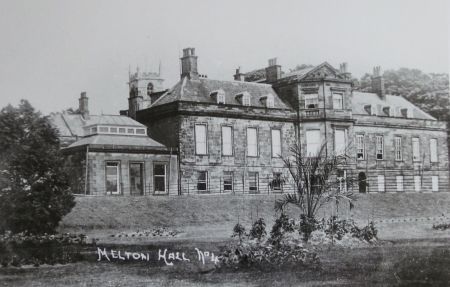
The hall’s origins possibly date back to the 15th century. In 1757, John Fountayne commissioned James Paine to remodel it, creating an H-shaped building built around a three-story tower. Significant alterations were made to the Hall by Richard Fountayne-Wilson in the 1820s, including new buildings to the north section of the house as servants’ service areas (1824-1826).
The final structural alterations made at Melton took place between 1874 and 1877 with the addition of the conservatory complex to the northern end of the Hall’s west front (DE2121-43, DE2121-04, DY SIM 7/8). After the 1927 sale, internal alterations took place to divide the Hall into a number of separate residences. By 1945 the Hall had ceased to be used for residential purposes and was redeveloped to open as a Teacher Training College in 1949 and continued to be altered until 1961.
St James’s Church [Grade II* - NHLE 1192208]
Dating from the 12th century, it was renovated in the mid 18th century by John Fountayne.
The Stables
These are first mentioned in the will of John Fountayne I (dated 19 April 1736) in which he leaves property to his wife including ‘the house wherein I now dwell, together with all the stables...’ (TNA PROB 11/682/8). Neither their location nor date of construction are known. They may be the ones shown on the 1848 Tithe map (No. 197) that were altered in the 1820s. The stables survived unchanged until 1930. After the sale, part of the west wing and all of the south wing were removed but were later restored in 1997.
Bath houses
The bath houses are on the western boundary of the Melton estate. The specific date of their construction is unknown. The earliest possible reference to their existence occurs in the letter from Simon Patrick in 1702 when he writes of visiting Melton ‘for his health’ (LaA SPG VII No 22). There are other bath houses and plunge pools at other local estates such as Hickleton, Bilham, Sprotbrough and Cusworth that date from around this time (Klemperer 2010, 391).
The bath house buildings and their associated ponds are first identified on the 1848 Tithe map (NA IR 30/43/282, Figure 4). There are two structures, one to the north above the first of the three ponds and the second at the south end of the plantation, west of the third pond.
The dwellings are variously referred to in census returns as ‘Bath House’ and ‘Bath Cottages’, with Bath House being the larger property to the north and Bath Cottages to the south, a row of three properties in the 1881 census. They were used as accommodation for estate employees, so they had ceased their original function by this time.
The icehouse [HE Scheduled Monument List No. 1020715]
The icehouse is situated at the south west edge of the former deer park (SE 508 014), on a steep southwest facing slope, 350 m due south of the Hall. There are also two ice ponds which were part of the water management and drainage system. The precise date of the construction is unknown, although its ‘cup and dome’ design mainly of larger bricks, would indicate that it was built between 1784 and c. 1820.
At the entrance, the door is surrounded by a Gothic arch and flanked by dressed stones, indicating that it was an aesthetic as well as a practical feature. It has been recently restored (see EH listing - https://historicengland.org.uk/listing/the-list/list-entry/1020715#contributions-banner, consulted 7 September 2020).
The Temple
The Temple is located in the woods known as Melton Warren, at the western end of High Melton village. It first appears on the 25” OS map surveyed in 1890 (Figure 6), however its origins may be earlier. In a letter in the Mexborough and Swinton Times of 6 April 1928, Mr J Worsley White, the Melton Estate’s land agent said:
‘The old “summer-house” in question was erected in the reign of George the Third as a place of rest for those desirous of viewing the great expanse of country visible from this eminence. The growth of the surrounding woodland removed its usefulness, with the result that the building was allowed to fall into decay. Your readers may be interested to know that a similar “Temple” was erected at Bilham but I understand that this has been blown down in a gale.’
There is a photograph (Figure 7) in the same paper on the 30 March. If Mr White is correct, then it would have been built between 1760 and 1820. However Melton Warren is not shown on Jeffrey’s map in 1771 (Figure 1) the site being an escarpment with no planting or buildings marked. Greenwood’s 1817 map (Figure 3) does show the wood although his statement that ‘the growth of the surrounding woodland removed its (The Temple) usefulness’ suggests from 1817 onwards views to the south and west were affected by the tree plantation.
The ‘similar Temple’ at Bilham Hall (4 miles north of High Melton) is the building known as the ‘Bilham Belvedere’ or ‘Summer house’. It was built c. 1800 by the architect John Rawstorne for Bilham’s owner William Hewett. Rawstorne had also been working at Cusworth Hall in 1797, so if he was the architect, the Temple would probably date from this period.
Orangery, later Aviary or Fernery?
To the northwest of the Hall, the 1891 estate plan (DA DY SIM 7/8) shows this as a glazed building. It may have been converted from an 18th century Orangery, as it is similar in the scale and proportions of its brick pillars and windows to one at Cannon Hall, near Barnsley. The building is thought to be part of an original kitchen garden wall with brick on inside and stone outside, visible behind the open flues.
Remains of the painted plasterwork are visible at the back of the building behind the arch, suggesting that the interim phase was for a well kept house used for growing or forcing plants which is when the glass roof is most likely to have been added (c 1826 onwards).
The building was then converted for a third time to the 'aviary’ or ‘fernery’ suggested by the addition of all the tufa which included planting pockets and the last possible date for the addition of a glass roof. The provision of a waterfall or stream with galvanized supply pipes running up behind the tufa to supply the water and the mock timber concrete handrails suggests this third phase was a late 19th century or early 20th century makeover (Jane Furse, pers. comm.).
It still survives but is a ruin (Figure 8).
Boat houses
The oldest boat house was situated at the southern edge of the Melton Estate next to the River Dearne, west of the icehouse. It appears as a building in a plantation on the 1848 Tithe map and the 1st Edition OS map of 1854. It is identified as ‘Boat House’ on the 1892 and 1903 OS maps and the plantation is named ‘Boat House Plantation’. A second Boat House appears further west along the course of the River Dearne with circular pond later a Duck Decoy (Figure 9).
Gardens and pleasure grounds
The early wills of Thomas Fountayne (1701) and John Fountayne I (1736) refer to the park and gardens. There are no further details of these apart from a letter in 1720 from Thomas Fountayne re obtaining turf from his neighbour that might imply the making or renewal of a formal parterre (LUSC YAS/DD38/533). John Fountayne II would appear also to be making garden improvements as his agent asked his neighbour again for turf ‘to finish a walk in his garden’ on 16 March 1761 (LUSC YAS/DD38/477). By the middle of the 19th century, the area north of the Hall had been laid out as pleasure grounds (Figure 5 – 1st ed OS) with Samuel Lewis noting in his 1848 publication A Topographical Dictionary of England that: ‘Melton Hall has extensive pleasure-grounds, tastefully laid out.’
The arrival of James Montagu and his family in the 1870s saw a significant development of the pleasure grounds and gardens over the next twenty years. The construction of the new conservatory complex attached to the north west wing of the hall in 1875-6 led to the development of the grounds in this area. In front of the conservatory, the open grassed area was extended and all the previous buildings (of the early kitchen garden) were removed to extend the pleasure grounds, with mixed tree or shrub planting. This level grassed area later contained six island beds and shrubs or specimen trees. A footbridge was built from the pleasure grounds to Melton Warren, crossing Doncaster Road (Figure 6).
The 1927 sale catalogue noted ‘the most attractive pleasure grounds planted with ornamental shrubs and trees containing rose gardens and tennis lawns’ (DY/DAW/9/75). According to Hurst’s history of High Melton Hall and Doncaster College (c 1965), the later tennis courts were constructed on the site of the former rose gardens, possibly now the car park due west of the former conservatory complex (DA SC3/12/13).
From the 1930s onwards the pleasure grounds are gradually reduced. West of the carriageway much of the planting had disappeared, with the rest thinned out and two thirds of conservatory complex had been removed. By 1961, a further clearing of trees has taken place in the area north of the tennis courts up to Doncaster Road and towards the footbridge to Melton Warren creating a clear view of the college complex above. Later other college buildings were added to the site of the former pleasure grounds.
Kitchen garden
There have been at least three walled kitchen gardens at High Melton. The first, to the northwest of the Hall was in place until c. 1850 and the second, due north of the Church, until c. 1896, and the third and final one to the northeast of the Hall by 1901 (Figures 10 and 11).
Little is known about the construction of the first kitchen garden. The only reference is Fountayne receiving vine cuttings from Francis Godolphin of Baylies in 1749 (NA F (M)G/797), which would imply the presence of a hothouse. This could be the ‘old stove’ referred to in later alterations of 1826 (NUSC Ma B 521.6). The possible orangery (see Section 4.7.7) is thought to be part of an original kitchen garden wall, so this may be the western wall of this first kitchen garden.
Richard Fountayne Wilson undertook improvements to the kitchen garden (NUSC Ma B 521/1-9) between 1824 and 1827. This was in an area due east of the orangery and perhaps was a later addition in the early 19th century.
A bill for the painting of a Hot House ‘inside and out’ in 1826 provides information about its size and design but not its location (NUSC MaB 521/5):
- There were two hot houses divided by a partition
- The rafters lineal measure was 80 yards
- There were 4 large and 4 small columns
- 183 yards of ‘laths vine rods’ existed
- There were 122 dozen ‘half squared’ to the roof inside and 139 dozen ‘half squared’ outside to be painted – presumably the frames for individual glazed panels.
- Total cost was £89 6s 21¼d
At the same time, work was taking place on the ‘vinery at Melton’ (possibly the earlier 18th C structure), altering the roof and renewing the installation of a stove. A joiner’s bill itemises the work carried out between October and December 1826 (NUSC MaB 521.6):
- Sashes to roof – making and fitting 858 feet
- Rafters to roof – making and fitting 239 feet
- Two sets of 4 columns
- Vine Laths
- Sash Door
- Total cost = £36 6s
The labour required for the above describes:
- Oct 11th 1826 – Apprentice and 2 men, 4 days pulling down old stove and taking glass out
- October 21st 1826 – 2 men and a boy taking end down and glass out
- November 1826 – 71 feet of new beads on the stove wall
- November 1826 - 6 days 3 men each fixing rafters and for stove
- Total cost = £42 8s 11½d
The third and final reference to the Kitchen Garden is provided by a mason’s bill of January 1827 who is measuring for ‘Kirb stone for Asparagus Beds’ but their location is not identified (NUSC MaB521.9)
By the late 1840s, the kitchen garden northwest of the hall was being dismantled and the area to the north of the church was being developed as an alternative site (Figure 10). Although much smaller, it did contain three glasshouses. This was superseded in the mid 1890s by the third and final garden. In March 1896 Messenger & Co quoted for a new boiler (LA DE2121 64) and a plant house and intermediate house (RUSC TR MES AD1/121). In 1904, Messenger supplied a patent lean-to peach house, measuring 65ft by 10ft (LA DE2121 46), which was built against the wall north of the main walled garden (Figure 11).
The census information reflected the increased demands of the final kitchen garden. Between 1841 and 1881, no gardeners are recorded living on the estate and only 1 living locally. By 1891 there were four gardeners, in 1901 there were six. Mr Robert Rickaby Whitfield was appointed head gardener to James Montagu in 1884, having formerly been the foreman at Marton Hall, Middlesbrough (The Gardeners Chronicle, 14 June). In the same year an advert appeared in the Gardener’s Chronicle for ‘a thoroughly competent young man to take charge of Houses, Stove and Greenhouse plants etc’ at Melton Park.
Mr Whitfield’s successor, Thomas Dixon Townend, worked at Melton from 1889 to at least 1897, possibly coinciding with the development of the third kitchen garden. Adverts were placed for ‘a strong active young man, not under 21, for kitchen garden, one wishing to improve preferred’ (Yorkshire Post and Intelligencer, 29 October 1891) and ‘a hardworking young man for fruit and plant houses, and to assist outside if required, one with a good knowledge of propagating preferred’. (The Gardener’s Chronicle, 18 April 1891)
Mr Townend’s expertise with flowers and plants is mentioned in newspaper reports of important family occasions e.g. the funeral of Andrew Montagu in 1895 and the second marriage of Mrs James Montagu in 1897 when the lilies, orchids, palms, ferns and dwarf fir trees are described as all coming ‘from the conservatories in Melton Park gardens’ (Mexborough and Swinton Times, 5 March). The valuable orchid collection was mentioned in 1891 in a probate legal case concerning the inheritance of the then 13 year old son of the recently deceased James Montagu (Northwich Guardian 21 February). Mr Townend also organised two of the Melton and Barlborough Horticultural Society exhibitions which took place in Melton Park in 1894 and 1895.
Further floral horticultural success for High Melton came with Mr E Hill gardener to Mrs Lindley Wood (formerly Mrs James Montagu) and her son Captain F.J.O Montagu c 1902 - 1910. Mr Hill had particular success with chrysanthemums, orchids and begonias at local horticultural shows, winning many prizes for Melton Park between 1902 – 1908.
In 1906 the Gardener’s Chronicle reported that the Orchid Committee had received from F.J.O. Montagu Esq a specimen orchid ‘Cattleya Schrőderoe ‘F.J.O Montagu’ with white sepals and petals and finest crimped tip with brownish orange disc and rose pink coloured front’.
The final advert for an experienced head gardener in 1925 requests expertise with vines and peaches (Yorkshire Post and Leeds Intelligencer, 6 May). The kitchen garden was described in the 1927 sale catalogue as ‘walled in on the North and East sides.... exceptionally well-stocked with fruit trees and includes greenhouses, vineries, peach houses, stores, potting shed, 2 gardener’s cottages, stables, storehouse and cart shed’ (DA DY/DAW/9/75). Lot 89a was the ‘Nurseries’ measuring 0.978a.
The glasshouses survived until approximately 1975 as shown in a photograph in the Doncaster Archives (DA SC3/13/6).
Park and plantations
Park
The parkland was established during Thomas Fountayne’s tenure from 1680 onwards or possibly by his brother John Fountayne Junior before him as it is shown on the 1711 map of the neighbouring Sprotbrough estate (DA DZ MD483). Between 1712 and 1720, John Fountayne I continued to extend his park into the Cadeby area, negotiating with his Copley neighbours at Sprotborough (DA CD 503/2; LUSC YAS/DD38/533). This enclosed park appears on the 1720 Warburton map (Figure 2). The 1724 map of Cadeby (DA DZ MD527) shows a slight increase to the parkland with this section noting this as part of ‘Mr Fountayne’s Park’ with Wildthorpe Cliff recorded to the south.
Further expansion of the parkland into Cadeby took place in 1748 (DA CD 38b, 25 May) together with the acquisition of 1a in Shearham Wood. Jeffrey’s map of 1771 (Figure 1) shows the enclosed park now stretching south along the length of the road between the Hall and St James’ Church to the east, terminating at a junction which continues on to meet Cadeby Lane. Two formal avenues of trees now led into the parkland. A path may date from this time, later known as ‘Dean’s Walk’, continuing beyond the park’s eastern boundary and passing over Wildthorpe Cliff. In 1861 nine beeches from it were sold in a major estate timber sale (Hull Advertiser and Gazette, 6 April).
The enclosure map of Cadeby (1809, DA MHD/36; DM MZ 71) shows further enlargement of the southern extent of the park. Through a series of exchanges with Sir Joseph Copley of Sprotborough, Fountayne Wilson made a net gain of 15 acres to his parkland. Greenwood’s map of 1817 (Figure 3) shows a new road to Cadeby with the previous one next to the Church having been removed, providing a greater degree of privacy and seclusion to the park’s south eastern aspect.
A repair bill c. 1826 itemises painting carried out to ‘deer barns and gates’ shows that deer were now kept in the park. ‘Garden pailing’ is also mentioned in the same bill perhaps relating to the original park enclosure paling shown in earlier maps. The 1857 Post Office Directory describes it as a ‘well-wooded park near the church, well-stocked with deer’ and is listed as having 50 fallow deer in 1892 (Whitaker 1892, 184).
The 1848 tithe map shows the whole park (Figure 4), which measured 42a 2r 3p, including a small plantation of 2r 10p at its south eastern corner. The southern park boundary then leads north-west to a 3 acre plantation, which appears in later maps as ‘Crow Plantation’. Clumps of trees are arranged along this boundary and in the southeastern section of the park. ‘Nelson’s Clump’ is shown as a small plantation standing at a central point between Crow Plantation and the Hall and presumably dates from c. 1805. The 1st edition 6” OS map, surveyed 1848 to 1850 (Figure 5) shows further planting at the southern end of the park towards the wooded area of Melton Cliff.
John Tomlinson’s description of his visit to Melton in 1860, captures the character of the parkland at the time:
‘My guide took me across a large paddock on to a steep eminence or crag, a little to the east of the park, which he said afforded a beautiful prospect. He was right and I could not but admit that this view over the Vale of the Don, over Mexborough, Wentworth, and Rotherham, on towards the bold hills around Sheffield was both more extensive and more varied than could be obtained, even from the old Castle of Conisborough. ‘But a still finer view,’ said my informant, ‘is gained from the front of Melton Hall.’ Before leaving Melton, I went into the park, which, although comprising not more perhaps than fifty acres within the enclosure, is exceedingly well wooded, and contains a few dozen heads of deer.’
The 1861 timber sale reveals the range and quantities of trees grown specifically in the park (Hull Advertiser and Gazette, 6 April) ‘MELTON DEER PARK. Lot VII. 62 Oak, 10 Ash, 5 Beech, 2 Maple, 1 Elm, and 2 Poles crossed; 9 Beech, standing in the Dean Walk, from No. 1 to 9.’ A later account of Andrew Montagu’s funeral describes ‘the whistling of the wind in the elms and beeches which are the glory of Melton Park’ (Yorkshire Post and Leeds Intelligencer,14 October 1895).
More planting continued into the beginning of the 20th century at three locations (Figure 12):
- A new major double avenue of trees sweeping south west across fields from Cadeby Lane to south of the hall joining Dean’s Walk
- The triple avenue beyond the park, north of the Bath Houses
- Melton Cliff has been replanted
In 1903 two trees (Cupresses alumii and Platanus occidentalis) were planted in front of the Hall to mark the coming of age and inheritance succession of Captain FJO Montagu (Sheffield Daily Telegraph, 3 September). An obituary of Captain Montagu recalled that he ‘did not much like the south aspect of Melton Hall and when the mineral railway was driven past the bottom of his park he stipulated for some discreet tree planting which anyhow did nobody any harm’ (Mexborough & Swinton Times, 20 April 1957).
After Doncaster County Borough’s 1948 purchase of the Hall and 116 acres of grounds (including the park and Wildthorpe), college facilities were built in the south west and south east sections of the park from the 1950s to 1970s, maintaining the open aspect immediately west of the Hall. Twenty-one trees were presented and planted in the grounds as part of the college’s silver jubilee celebrations of 1974 (DA SC3/10/2).
Melton Wood
Melton Wood is first mentioned on a map of 1765 (DA DD/BW/E7/36) but may well date from the early 1700s as its rides are similar in style to those at Little Hay Wood at nearby Sprotborough, created by Godfrey Copley before 1709 (Klemperer 2010, 196). Jeffrey’s map of c. 1771 (Figure 1) shows three rides radiating from the southern point of the wood, including a central north-south axis. From a westerly point three routes radiate, including a central west–east axis. Two long parallel rides run across the wood - northwest to southeast. There are three route intersection points along the north–south axis with the central one accommodating eight junctions. Some modifications had been made by Greenwood’s map of 1817 resulting in a slightly simpler design by removing the east-west axis and shortening the north-south axis at its northern end.
The wood covered just over 215 acres in 1848 with the tithe map (Figure 4) showing further changes had been made to create a more asymmetric design. It was now dominated by two major axes and the north-south axis has regained its length. The east-west axis (an established bridle path) had been reinstated to connect with Hangman Stone Lane to the west. The paths at the lower southwest corner had disappeared. It then remained virtually unchanged in terms of its layout of rides and paths until 1927.
Melton Wood’s new owner needed wood for housing and a deforestation programme was carried out, particularly in the southern section. Once densely wooded, now ‘the countryside was disfigured by mutilated trees, gaunt and ugly suggesting a shell-torn area.... since they were despoiled, the chief charm of this pleasant outskirt of the town is gone’ (Mexborough and Swinton Times 12 October 1927). Ownership of Melton Wood then passed from the National Coal Board to the Forestry Commission. A scrub clearance and replanting programme of broad-leaved and coniferous trees created the present day attractive mixed woodland. In 1992 Doncaster Council purchased the freehold of Melton Wood to maintain public access and to ensure its conservation. Today as Melton Country Park, it is a valued community leisure facility using much of the network of surviving 18th and 19th century paths and rides.
Melton Warren
It is first shown on Greenwood’s map of 1817 (Figure 3) as an irregular densely planted area, almost a reversed ‘S’ in shape. It tapered up to its northern point just south of the junction of two roads and had an eastern spur cutting west east towards hangman Stone Lane. Its shape had changed significantly by the 1848 tithe map (‘Warren and Cliff Plantation’ measuring just under 38 acres). Now more of an ‘L’ shape, its elongated western boundary, a short distance east of Hangman Stone Road, now formed a longer, thinner plantation stretching northwards almost to Hangman Stone Corner. The former eastern spur has disappeared.
The 1st edition 6” OS map shows a path or ride cuts through almost its full length, passing close by the location of ‘The Temple’ (not marked) suggesting that the it was now used as a pleasure ground. John Tomlinson provided a description in 1860:
‘extending more than a mile is a line of tall abrupt crags covered with trees and under-wood, but which are partly concealed from the road by a high stone wall. This is Melton warren tenanted by thousands of hares and rabbits. The turnpike is formed towards the base of these immense crags while, to the right, the land suddenly dips and then sweeps away on a gradual incline forming a magnificent prospect of park scenery, bounded in the distance by the huge perpendicular ridges of Conisborough Cliff and Levitt Hag.
A local newspaper feature from 1877 highlighted the attraction of this area, as seen passing through High Melton from east to west:
‘Descending Melton Hill in the direction of the village a beautiful mass of foliage which lies near meets the eye. On the right, secured from the road by a long high wall, is Melton Warren, whose noble timber trees, high branched and luxuriant, overlook the whole scene.... A slight turn to the right presents the direct road to Barnburgh which is to be seen on the rising ground opposite. Near at hand is a small range of cottages known as Ludwell. The view here is very fine, embracing the landscape, the cliffs of Barnburgh, Hoober Stand, Denaby etc’ (Mexborough and Swinton Times, 28 December)
By 1890 the Warren now had a private estate entrance with the walkway/footbridge from the Hall grounds which survived until c. 1978/9. ‘The Temple’ (see Section 4.7.6) is marked for the first time on the 1892 OS 25” map, perhaps restored as a result of the creation of the path which lead immediately past it. The eastern spur was extended with additional planting and more paths had been added, together with extra planting to the southern side of the eastern projecting spur by the early 1900s.
By the 1920s parts of Melton Warren had become overgrown and inaccessible, which possibly led to the reduced length of the main walk westwards from the footbridge exiting Melton Park pleasure grounds, which no longer reached the Temple. Access from Hangman Stone Road just above Ludwell Cottages remained as did the paths in the eastern spur. In October 1928 the northern portion of Melton Warren was advertised for sale (just under 35 acres). The lower section has survived mainly unchanged and limited public access is still available via a single marked path.
Avenues
Three double avenues of trees were part of High Melton’s designed landscape, as approaches to/from the parkland and pleasure grounds. The first led to the western estate boundary, meeting Melton Mill Lane, from 1771 onwards, surviving until 1964. The second left the park boundary and descended south west to the Mill Race tributary from the River Dearne, but no longer appears after 1771. The third, created at the eastern edge of the estate between 1890-1901, ran northwards from the Dean’s Walk in the parkland to the junction of Cadeby Lane, Sheep Lane and Melton Road, and has survived largely intact.
Water
Bath Ponds
There are references to ‘fishponds’ are recorded in documents of 1651 (NUSC Ga 127.68) and 1736 (TNA PROB 11/682/8) but it is not certain that these later formed the bath ponds. They are first shown on the 1848 tithe map as three distinct long, narrow ponds, evenly spaced along the western edge of the plantation. By 1854 they had reduced in shape and number to two large round ponds, the southern one slightly larger than the other (Figure 5). An estate plan from 1891 shows the two ponds and their water source Bath Spring (DA DIY/SIM 7 8). The plan relates to improvements made to the water supply to Melton and the installation of fire hydrants and stand points in the Hall and village (Mexbrough and Swinton Times, 10 February 1893). This required a covered reservoir to be constructed in Melton Wood.
In the 1927 estate sale catalogue the ponds are listed as measuring 0.284a and they passed into private ownership following the sale. The 1932 OS map surveyed 1928-9 shows the southern pond is now smaller, and there were no further changes from 1948 onwards. The Bath ponds still survive as part of the residential properties now occupying this site.
The Ice Ponds
The first is c.10m southwest of the icehouse at SE 50820 01447 (‘upper’) and is linked to the second c. 80m southwest of the icehouse at SE 50775 01408 (‘lower’). The latter then drains to the river Dearne. The lower pond has retaining stone walls like the icehouse itself (Briden 2015, 4) and used primarily for collecting ice. It was circular with a diameter of 17m and was likely to be fed by a spring that may have determined the position of the icehouse in an otherwise remote part of the park (ibid, 7). The upper pond was rectilinear, about 11m square, with earthwork banks (ibid, 8) and used mainly for drainage from the icehouse (ibid, 9).
Other water features
In the first kitchen garden west of the Hall a circular pond (perhaps initially a dipping pond) can be seen on OS maps until 1932 but then disappears.
Books and articles
Briden, C. 2015. High Melton Hall Ice House – Historic Building Assessment. Unpublished research report.
Collins, F. ed. 1889. Feet of Fines of the Tudor Period Part 3, 1583-94. Leeds, The Yorkshire Archaeological Society.
Colvin, H. 1978. A Biographical Dictionary of British Architects, 1600-1840. London, John Murray.
Surtees Society 1867. The Survey of the County of York taken by John de Kirkby. Durham, Andrews & Co.
Klemperer, M. 2010. Style and Social Competition in the Large Scale Ornamental Landscapes of the Doncaster district of South Yorkshire c. 1680-1840 (BAR British Series 511). Oxford, Archeopress.
Whitaker, J. 1892. A Descriptive List of Deer-Parks and Paddocks of England. London, Ballantyne Hanson & Co.
Primary sources
Bedfordshire Archives (BA)
L 30/15/54/225 Letter from Lord Grantham to Frederick Robinson, 27 June 1784
L 30/14/333/295 Letter from Frederick Robinson to Lord Grantham, 3 January 1785
L 30/14/254/11 Letter from Adam Mickle to Frederick Robinson, 10 February 1788
Doncaster Archives (DA)
CD38b Notes re exchange of parcels of land in Cadeby Fields between John Fountayne and Godfrey Copley of Sprotbrough, 1745-51
CD 503/1 Letter from Thomas Fountayne to Godfrey Copley, 9 September 1701
CD 503/2 Letter from John Fountayne to Lionel Copley, 10 October 1712
CD 503/5 Letter from John Fountayne to Lionel Copley, 24 May 1716
CD 503/6 Letter from John Fountayne to Lionel Copley, 2 June 1716
CWM/154 Release and discharge from an annuity from Edmund and Mary Hastings to John Levett, 29 May 1637
DD/BW/E7/36 Plan of an intended new road from the west end of Melton Sheep Lane to where it meets the old road at Cusworth Lane End near York toll bar and likewise the old road intended to be shut up, August 1765
DD/CROM/6/32 Copy of tithe map incl Cadeby 1847
DD/DC/D/914 Lease for 20 years to Edward Churleley of the former chantry in High Melton parish church and all land belonging to it, 4 Feb 1549
DM/NZ/71 Enclosure Plan for Cadeby 1809
DY/DAW/9/75 Sale document and plan of High Melton Estate, 1927
DY/SIM/7/8 High Melton Hall plans 1891
DZ/MD 483 Plans of Bilham, Cadeby etc by Samuel Grover, 1711
DZ/MD 527 Plans of lordship of Cadeby, belonging to Godfrey Copley, by Henry Walker, 1724
MHD36 Exchange of lands, Richard Fountayne Wilson to Sir Joseph Copley, 2 November 1810 [Cadeby]
SC/3 Doncaster College Archives
12/13 Essay on High Melton Hall by EM Hurst c. 1965
Lambeth Archives (LaA)
SPG VII No 22 Letter from Simon Patrick, Bishop of Ely, 16 May 1702
Leeds University Special Collections (LUSC)
YAS/DD38/477 Letter from John Hall, High Melton, [agent to Dean of York] to Edward Strutt, Sprotbrough, asking for permission to cut a few sods on Wildthorp Cliff to finish a walk in his garden. 16 March 1761
YAS/DD38/533 Letter from John Fountayne to ‘Madam’ at Sprotbrough, 6 September 1720
Leicestershire Archives (LA)
Messenger & Co account books (DE2121)
04 General Ledger 1875-1879, p361, Account for work done at Melton Park [payment for 43 below], 1876/7
43 Contract Book 1875-77, p91, Estimate for work at Melton Park [conservatory complex?], 7 July 1875
46 Plan and Contract Book 1903-05, Plan 0773, Schedule for work at Melton Park [patent lean-to peach house 65x10’], April 1904
64 Heating List Book 14 Oct 1895-24 Sept 1901, p108, Estimate for work at Melton Park [boiler?], March 23 1896
Northamptonshire Archives (NA)
F (M)G/797 Letter from John Fountayne to Francis Godolphin thanking him for the vine cuttings and giving notice to his head gardener at High Melton, 20 December 1749
Nottingham University Special Collections (NUSC)
Ga 12.768/1-70 Letters from Richard Berry to his nephew, Marmaduke Monckton, 1649-51
Ga 9321 Agreement between John Fountayne, John Fountayne the younger, Mary Monckton and Elizabeth, her daughter, concerning intended marriage of John Fountayne the younger and Elizabeth Monckton and the settlement of lands etc., including those which came to John Fountayne senior by will of Richard Berry, 28 March 1666
Ga 9976 Notes on debts of Dr Berrie, annuities by deeds of Dr Berrie, and encumbrances on Melton, late 17th century
Ma B 521/1-9 Accounts of building and decorating work at Melton Hall, Yorkshire; 1824-1827
The National Archives (TNA)
C5/17/171 Whitaker v Fitzwilliams, Levett et al, chancery bill dated 26 October 1653
C5/17/172 Answer of John Levett to bill (ref. 171), 9 February 1654
C143/102/23 Margaret de Sancto Georgio grant of the manor of Melton-on-the-Hill to Robert Haringel, 1313/4
C142/177/74 Inquisition Post Mortem of John Levett, 29 May 1577
C142/198/52 Inquisition Post Mortem of Ralph Levett, 3 November 1582
IR 29/43/282 Tithe award for Melton, 1847
IR 30/43/282 Tithe map for Melton, 1848
PROB 11/217/415 Will of Dr Richard Berry, written 28 May and proved on 4 July 1651
PROB 11/243/382 Will of John Monckton of Melton on the Hill, proved 13 February 1655
PROB 11/518/338 Will of Thomas Fountayne of High Melton, written 20 September 1701 and proved 7 December 1710
PROB 11/682/8 Will of John Fountayne of High Melton, written 19 April 1736 and proved 1 March 1737
Reading University Special Collections (RUSC)
TR MES AD1/121 Structure: Plant house and intermediate house; Peach House Location: Melton Park, Doncaster, South Yorkshire. Client Mrs Montagu, 1896 & 1904 [Messenger & Co]
West Yorkshire Archive Services Wakefield (WYASW)
QS10/63 Quarter Sessions Order Book, October 1873 - August 1877
Maps
John Warburton map of Yorkshire, c. 1720
Jeffrey’s map of Yorkshire, c. 1771
Greenwood’s map of Yorkshire, 1817
Ordnance Survey 6” 1st edition, surveyed 1848 to 1850, published 1854
Ordnance Survey 25” 1st edition, surveyed 1890, published 1892
Ordnance Survey 6” edition, revised 1901, published 1903
Ordnance Survey 25” edition, revised 1901, published 1903
Ordnance Survey 25” edition, revised 1929, published 1930
Newspapers
Hull Advertiser and Gazette
Leeds Mercury
Mexborough and Swinton Times
Northwich Guardian
Sheffield Daily Telegraph
The Gardener’s Chronicle
Yorkshire Evening Post
Yorkshire Post and Leeds Intelligencer
Figure 1 - Jeffrey’s map of Yorkshire, c. 1771 (Plate 18). Source NYCRO, ref ZDU[1]42
Figure 2 - John Warburton map of Yorkshire, c. 1720
Figure 3 - Greenwood’s map of Yorkshire, 1817. Source: Sheffield Archives, SY 109/Z1/1
Figure 4 – Tithe map of High Melton, 1848
Figure 5 – Ordnance Survey map 6” 1st edition, surveyed 1848 to 1850, published 1854. Reproduced with permission from the National Library of Scotland.
Figure 6 - Ordnance Survey map 25” 1st edition, surveyed 1890, published 1892. Reproduced with permission from the National Library of Scotland.
Figure 7 – Photograph of ‘The Temple’, 1928
Figure 8 – Photograph of the former Orangery and possible aviary/fernery taken in 2010
Figure 9 – Boathouses and duck decoy pond from Ordnance Survey map 25” edition, revised 1901, published 1903. Reproduced with permission from the National Library of Scotland.
Figure 10 – Photograph of the Hall (West Front) with island bed planting, c 1900. Private collection.
Figure 11 – 1st and 2nd kitchen gardens on the 1848 tithe map and 1st edition 6” OS map. Reproduced with permission from the National Library of Scotland.
Figure 12 – 2nd and 3rd kitchen gardens on the 1st edition and revised editions of the 25” OS map. Reproduced with permission from the National Library of Scotland.
Figure 13 - Ordnance Survey 6” edition, revised 1901, published 1903. Reproduced with permission from the National Library of Scotland.
Figure 14 – Photograph of walkway from pleasure grounds to Melton Warren (undated). Private collection.
.")


 with island bed planting, c 1900.")


.")