There have been three designed landscapes surrounding the three main buildings that have been erected in the area known as Moreby (or Moorby). The first, adjacent to the medieval Moreby Hall belonging to the Moreby and then Acklam (or Acclom[e]) family, was a park in the southern section. The northern half was developed by the Lawson family from the 17th century and the grounds around the second Moreby Hall were landscaped by Marmaduke Lawson, a noted plantsman.
The two estates came together in 1787 and in the 1830s, an early formal style garden was put in to complement a new country house by the architect, Anthony Salvin, for Henry Preston. The surrounding parkland was extended south and east, the latter following the move of the York-Stillingfleet road further east. This last park and garden largely survives in terms of layout and style and was the reason for its inclusion on the Historic England Register.
Estate owners
The current Moreby Hall was built between 1828 and 1834 by Henry Preston but replaced an earlier building that lay to the south of it. The latter had been the home of the Lawson family, who acquired the estate in the early seventeenth century. By 1672, they had a modest house of 7 hearths, although a more substantial building appears to be shown in the sketch by Samuel Buck in the 1720s. Marmaduke Lawson inherited the estate from his father in 1698 and may well have made the significant improvements to the park and garden shown on Jeffrey’s map of 1771. His sons had died without heirs and so he passed Moreby to William Preston, his wife’s nephew, in 1762, who acquired the neighbouring estate belonging to Ralph Milbanke in 1787.
William had no direct heirs, so Moreby went to his younger brother, Rev. Thomas, in 1791 who lived there until his death in 1827. As Thomas died childless, the estate went to his nephew, Henry (son of William and Thomas’ brother, Henry), who made significant changes both to the principal house and to the landscape around it between 1828 and 1849. He also purchased significant lands in neighbouring Stillingfleet and Kelfield in 1827 and 1828 respectively. Moreby passed to Henry’s son, Thomas Henry, in 1857 and on the latter’s death in 1906, to his son Henry Edward. Henry’s two children, Thomas and Beatrice started to sell off parts of the wider estate in the 1950s but retained the Hall and 90 acres of the parkland. The latter was finally sold in 1985 to the Greenan family with the Preston family keeping the walled kitchen garden where they built a house.
Key owners:
- Marmaduke Lawson b1685 (1698-1762)
- William Preston b1723 (1762-1791)
- Rev. Thomas Preston b1742 (1791-1827)
- Henry Preston b1779 (1827-1857)
Early history of the site
In the Domesday book, there were 2 estates at Moreby. The first, formerly a manor, of one carucate (about 120 acres) belonged to Count Alan of Brittany (part of his Clifton manor). It had meadow of 26 acres and woodland of 2*2 leagues (about 9 square miles or 5760 acres), shared with his nearby holdings in Escrick and Riccall. The second, also of one carucate, belonged to Hugh, son of Baldric and had 20 acres of meadow and shared 1*½ leagues of woodland (about 320 acres). Whether these were the same two estates but by the late 13th century, one was owned by Robert de Grey (‘Moreby Manor North’) and the other by William of Moreby (‘Moreby Manor South’).
The former (or ‘Moreby Manor North’, see Figure 1) passed to the Crown in 1485 and in 1529, John Wellisburne sold it to (Sir) Leonard Beckwith of Stillingfleet for £100 that year and it was described as:
‘4 messuages, four tofts, and closes in Moreby called 'Gossostecroft', ‘Haverlands’, 'Brigfeld', 'Shawfeld', 'the Southfeld', 'the Southgrene', 'Newriddyng', 'Stokkisriddyng', 'Burnehyrst', 'Old Ryddyng', 'Mekill Carre', 'Armetparke' and 'Littilwodend' and a wood called 'the Southgaile' (PRO E 40/1360)
Sir Leonard died in 1557 and his estate was inherited by his son, Roger, who sold (part of?) the estate to Edward Talbot. He, in turn, sold it on to Thomas Beckwith (possibly a cousin of Roger). However this was challenged by the family of Roger’s two sisters, Frances and Elizabeth. Around 1580, Talbot was taken to court by Frances and her husband, Henry Slingsby and Frances (Elizabeth’s daughter) and her husband George Harvey. In the court document, the disputed landholding is given as:
‘A capital messuage, grange, or farm called Moreby [Moreby Grange Farm] in Moreby, Yorkshire, with 120 acres of arable land, and 100 acres of meadow’ (PRO C 2/Eliz/T3/51)
In 1598, there was an Exemplification of proceedings leading to a Final Concord [agreement] between Mauger Vavasour and William Tankarde esquires plaintiffs and George Harvey esquire & wife Frances, Henry Slingsby esquire & wife Frances deforceants for the:
‘Manor of Morebye with 100 ac. land, 50 ac. meadow, 60ac pasture, 80 ac. wood and 100 ac. heath and furze’ (U DDPR/12/9)
In 1604, it was sold by Henry and Frances Slingsby to George Lawson for £1560 (U DDPR/12/10) and it included 4 ‘messuages’ (U DDPR/12/12).
The Lawsons were a well-connected family from York. George’s great-grandfather, Sir George, had been the MP for York and its Mayor in 1530. His son, Thomas, also became Mayor in 1562. Peter, Thomas’ son, married Elizabeth Beckwith, daughter of Ambrose and niece of Sir Leonard. George died in 1640 and Moreby passed to his son, the Rev. George (1606-1670) who was the Vicar at Eakring in Nottinghamshire. Apart from a brief period during the Interregnum, he lived at Eakring until his death. His son, George III (1659-1698/9) however did live there, as did his son, Marmaduke, until the latter’s death in 1762 when it passed to the Preston family.
During the 17th century, this part seems to have acquired the status of ‘manor’. In the Inquisition Post Mortem of George I (1640), it is described as:
‘Capital messuage or farm called Mooreby and lands there which he acquired from Sir Henry Slingsby of Scriven and wife Frances (by deed of 20 April 1603)’ (U DDPR /12/4).
By the time of George III’s marriage settlement of 1680, it is now referred to as:
‘Manor, capital messuage and estate of Mooreby (reserving woody grounds called Woodend, Woodend or Lady Wood, and Spring Wood)’ (U DDPR /12/19).
Indeed by the time of the sale of the lands belonging to the Milbankes in 1787, a lawyer on behalf of William Preston disputed the claim of the vendor that they had the right to tithes. The reason he gives is that ‘it does not appear by any of the Title Deeds that a Manor, or even a reputed Manor, has ever been claim’d by the Milbank family’ (U DDPR /12/42).
‘Moreby Manor South’ (see Figure 1) came into the Acklam (or Acclom/e) family through the marriage of Mary, daughter of Henry Moreby, to William Acklam about 1370. It remained in the family until the marriage of Elizabeth, sole heiress of John Acklam, to Sir Mark Milbanke in 1659. It was this estate that Ralph Milbanke sold to William Preston in 1787, when the two estates merged.
It would appear that only the southern manor was occupied by its owners until the 17th century. The Acklam family had a manor house, with chapel by 1493 (Raine and Clay 1865, 358). The manor was described thus in 1552 in the Inquisition Post Mortem for John Acclom:
‘Manor of Moreby with Moreby Hall and closes called the Parke, Twentie Acres, Bull Ridding, Fogge Close, Four Acres & Smithe Close (with herbage of the wood there); parcels adjacent to New Lane on E. side of the Parke, Gosse Crofte; a lane with Stayne Ridding & Osmond Ridding; a lane between Great Meadow & the Parke; and 19 1/2ac. in Great Inges, all in Moreby’ (U DDBH/3/78).
John Leland in his itinerary of England between 1535 and 1543, describes the house and park: ‘Beyond this [Bishopthorpe] 3 miles the ground waxith sumwhat wooddy, and about the 3 mile I cam hard by Mr. Aclam’s parke wherin is a preaty dwelling place’ (Leland and Smith 1906, 12).
It was rented out after the marriage to Elizabeth to Mark Milbanke, as no family is recorded there in the hearth tax of 1672. In 1749, there is an advertisement in the York Courant:
‘To be let, 4 Miles south from York, and near the navigable River Ouse Moreby Hall, with the Paddock stock’d with deer (there were about 18 brace), two orchards. Planted with good fruit and bears well, the garden with fish ponds and what ground adjoining to the house there is occasion for – the house may be seen any day, and entered at pleasure and let for any term of years.’ (Neave 1991, 44).
In the sale document of 1787, it is recorded that the tenant was Paul Parkins (U DDPR/12/42). This thought to be the present ‘Home Farm’. The possible site of the park referred to above and in the 16th century document is shown in Figure 2.
Chronological history of the designed landscape
1700-1828
Marmaduke Lawson married Susanna Preston on 7 January 1702/3 and came of age in 1706. Susanna was the daughter of John Preston, a successful merchant from Leeds. Through his mother, Marmaduke had also inherited the estate at Seaton Ross. The building shown in Samuel Buck’s Yorkshire Sketchbook would appear to be more substantial that the ‘7 hearths’ recorded in 1672, so the house may well have been enlarged in either in his father’s time or after his marriage. His wife died in 1711 and the following year, he married again to Grace Brooksbank. While there were four children (including two sons) from the first marriage, there were no children of the second.
In the late 1720s, it would appear that Lawson was having problems with finance as a number of farms on his estate were mortgaged. Unlike his peers, who were able to convert part of their estates from farmland to landscape parks, this shortage of money meant he had to maximise the estate income. A large part to the west was wooded, possibly being remnants of the ancient woods mentioned in the Domesday book and shown on the Jeffreys map of 1771 (see Figure 2).
Marmaduke started selling charcoal and other timber, including young trees, to many of the leading estates. His record of sales is in the Hull Archives (U DDPR/47/1) and shows the extent of the business. It is perhaps no co-incidence that he was a subscriber to Switzer’s Practical Husbandman and Planter, or, Observations on the Ancient and Modern Husbandry, Planting and Gardening, Etc: in 1733, as was Thomas Knowlton, gardener to Lord Burlington at Londesborough.
There has been speculation about the ‘Mr Lawson’ who collaborated with Thomas Knowlton at Everingham (Henrey 1986, 276), as documented by the letters between the absent owner, Sir Marmaduke Constable, and his steward, John Potts (Roebuck 1976). The records in the account book (U DDPR/47/1) make it clear that it is Marmaduke Lawson, as these entries show:
April 1732 (from Moreby) To Sir Marmaduke Constable 388 rails, 300 yards at 6 score, 19s 10d; to ditto 43 posts 4s 6d
1742 To Sir Marmaduke Constable 14 oak trees 5 & 6ft at 1s 6d per ft comes to £13 14s 8d
Knowlton and Lawson worked on the development of the designed landscape at Everingham from about 1727 to at least 1743 (when the correspondence ends). Lawson’s exact role apart from supplying trees is not clear as Potts comments:
‘The first is concerning the hall Garth. Before that work was begun I desired Mr Lawson and Mr Knowlton to come here and agree upon the most proper, and cheapest way to doe, the latter [i.e. Knowlton] is the only director, and to his judgement I referd the whole work, since the other [i.e. Lawson] never came but once after’ (Letter from Potts to Constable, 30 January 1731, U DDEV/60/86).
However it seems that Knowlton did respect Lawson’s ability with regard to tree planting:
‘[Knowlton] thinks it impossible to remove so great a quantity of [elm] trees as you have at Scorborough in one season, and therefore advises to divide ym into three, and to draw the strongest first. He will meet Mr Lawson here, who he says, and I believe knows more of yr designe in that kind, than any else’ (Letter from Potts to Constable, 2 August 1731, U DDEV/60/86).
It would also appear that Lawson had been supplying fruit trees for some time as on 8 May 1727, Potts observes that:
‘The Pear tree which was grafted three years ago as you goe out of the Garden to the Dog Kennel from Mr Lawsons grafts has a pretty quantity of Pears on it’ (U DDEV/60/84).
The Jeffery’s map of 1771 shows a park at Moreby to the south of the Hall, surrounded by a fence and two avenues, one running north to south and another from the road through the centre of the other. These appear to still be existence by 1846/7 when the first edition of the Ordnance Survey map is surveyed. John Burr in a letter of 18 January 1839 refers to the trees damaged in the ‘old avenue’ by a violent storm (U DDPR/50/23). There are also some trees marked to the north of Hall on the Jeffrey’s map.
There are no existing detailed maps of the estate until a sketch drawn up in 1829 for the diversion of the York to Stillingfleet road (ERA HD33). Figure 2 shows the park with three unidentified buildings on the southern boundary that had disappeared by 1842. To the north-east of the Hall are two enclosures that perhaps were the kitchen gardens. This was the area where the new Hall was constructed and so they would have been relocated. The orchard where the fruit trees were grown was perhaps in narrow close that ran parallel to the park and where a fishpond was created later. Burr refers to the damage of an ‘old apple tree’ in this area in 1839 (U DDPR/50/23).
Under the terms of Marmaduke’s will, the estate should have gone to his brother, Richard, but he predeceased Marmaduke by 6 months, so it went instead to his wife’s nephew, William Preston. Both he and his brother, Thomas, who succeeded him, did not enlarge the parkland despite buying the estate to the south in 1787. The map of 1829 (ERA HD33) still shows a clear division between the parkland to the north and the south.
1828 – 1849
The decision to build a new house by Henry Preston in 1828 also impacted on the designed landscape. The new building was to be to the north of the existing one and presumably this affected the gardens there, in particular the probable kitchen garden. He employed first as head gardener, Thomas Deuxberry (or Duxberry) to oversee the changes.
Deuxberry was born in 1797 in Weston, near Otley, the son of Thomas who later (from the 1820s) is described as a nurseryman, seedsman and gardener with a business in Bay Horse Yard, Otley. Deuxberry had previously worked at Horsforth Hall (6 miles northwest of Leeds). He won many prizes at shows, including the Yorkshire Horticultural Society, where he was particularly commended on 3 September 1828 (Leeds Intelligencer, 4 Sep 1828). Two years later he won the Silver Medal awarded by the Royal Horticultural Society to the Yorkshire society for winning the most prizes (Yorkshire Gazette, 8 May 1830). As Henry Preston was a member of the Yorkshire Horticultural Society, he may well have recruited Deuxberry personally.
Deuxberry’s first task while the new house was being built was the construction of the new kitchen garden. It is not shown on the 1829 sketch map (dated 17 June) but as Deuxberry was once again winning prizes for wall trained pears and peaches by September that year (Leeds Intelligencer, 1 October 1829), the new garden may well have been in place by then. Deuxberry left in 1831 and his advertisement for a new position in May 1831, he says that ‘he perfectly understands gardening in all its various departments – having himself laid out the beautiful and extensive Gardens, Hot Houses and Green Houses &c. belonging to Mr. Preston’ (The York Herald, 28 May 1831).
Why Deuxberry left is not clear although as he had no job to go to, Henry Preston must have felt he needed a new head gardener. The new house was nearing completion in 1831 and so work could start on the gardens around it. The new head gardener was John Burr, who was there by April 1832, when the first payment is made to him (U DDPR/47/6). Burr, who is credited by Jane Loudon as the designer of the gardens, was born c1808 in Sedgefield (County Durham), the son of George, also a gardener.
Where Burr worked previously and gained his experience is not known. John would have been only about 24 on his appointment, so Preston must have been confident in his abilities, possibly based on a recommendation. His father was working in Sedgefield from about 1808 to 1818 and then Hallgarth (near Pittingham, north-east of Durham) around 1823, so he and his son may have come into contact with Anthony Salvin who was brought up in Durham and worked at nearby Brancepath Castle (1818-21) and 1829.
Judging by the bill from William Massey, a timber merchant from Sutton on Derwent (U DDPR/47/25), significant work was undertaken by Burr following his appointment:
- 1833, Work in Gardens by order of E Spence?
- 1834, Mr Burr House, £247 10d (Moreby Grange); Garden, Shade & Garden Walls, £26 8s 7d; Fish Ponds, £2 1s 2d & Hot house £12 18s 11d
- 5 September 1834, Moreby Hall Vine House
This is also shown by the payments made to Burr by Henry Preston in 1833 and 1834: £100 31s 7d and £279 6s 11d respectively (U DDPR/47/6 and U DDPR/47/7). On the 3 October 1835 (U DDPR/47/8), there is also a payment of £15 16s to Messrs Backhouse [the nursery in York].
A number of letters between John Burr and Henry Preston in 1838 and 1839 (U DDPR/50/24 and U DDPR/50/44) describe the improvements undertaken. These included the gardens immediately around the house (terrace and parterre), the pleasure grounds to the west next to the pond and summerhouse, the park with its plantations and possible new entrances.
21st October 1838 (U DDPR/50/24)
Burr says that he has increased the size of the proposed terrace to include more of the area below the conservatory and improve the overall design. He notes: ‘the space between the walls I then filled up to the back of the upper terraces, the appearances of being the width of both, the Garden being merely a sunken part of the same terrace so in other words to bring them both into one’.
There were new plantations as one of the workers, Fearn, ‘too has been employed all the summer fencing’ them and ‘the Plantation and coach roads got mowed and cleaned’, however ‘for the pleasure ground with the exception of the gravel little was done’.
Work had continued on the parterre or ‘flower garden’: ‘I then got all the plants and gravel out of the flower garden to be ready for the autumn and filled their space on the terrace…We are now laying out the flower garden according to the plan… The box is nearly all planted, the Gravel is yet to be got in and then if the weather permit I hope to be able to do the Terrace Garden’.
6 March 1839 (U DDPR/50/24)
Burr is making plans for the area around the building (c1832) at the southern end of the lake: ‘I could conceive something ornamental of the little summer house, in what was Miss Preston’s garden by mowing it and connecting it with an aviary.’
Other work that he is engaged in is as follows: ‘I have about a fortnight’s work gravelling the Court and altering the coachroad besides planting up within the hurdles with the evergreens and afterward your Walk by the River shall be got on with.’
19th July 1839 (U DDPR/50/24)
In this letter, he gives:
‘an account of part of the work done during the Spring and Summer:
- Pruned and thinned the Plantations and Shrubberies about the Pond and Pleasure Ground
- Planted several small plantations in the Park as you desired one Sir, these have done well and improve the Park very much
- I then began again with the lower flower garden and here I have a great part of the Box to replant the winter having killed the most of what planted in the autumn
- The terrace was the next job which I laid out, gravelled and stocked with plants propagated during the spring in expectation of your return. The lower border likewise gravelled and stocked with plants but not of a very choice description’.
13th October 1839 (U DDPR/50/44)
Burr continues to work on the park, as he notes: ‘with regard to the Plantation in front of Mr Baines [of Bell Hall], I am not sure that I can much improve it: trees of so many years standing are better than any that may be put in now though these have not grown so well as many others. Yet they are gradually becoming a good block which in a very few years will leave you nothing further to wish for. There is perhaps one opening where a few trees may be of service. I want during the winter a few more close groups planting in different parts of the park which will require fencing.’
In other areas though, it seems that Henry Preston was deciding on the design. Burr disagrees with his master’s plan, as he says ‘I want before the winter, your directions about the walk from the new steps to the river, I should like for to be allowed to do it differently. Your plan has always been to have a straight walk. This has prevented me finishing it. I can see no way of carrying this into effect to satisfy myself but I think I can effect all you desire my own way.’
In 1842, Preston’s application to move Moreby Bridge and the road that crossed it was approved. It moved the road north and ran parallel with some existing woodland (ERA HD51). By the time of the 1st edition Ordnance Survey map (surveyed 1846 to 1847), the designed landscape is almost complete. The parkland now stretched just north of Moreby Bridge (next to Thomas Dike Reach) to south of Home Farm. The gardens around the house are marked: terraces and bowling green to the south and a rosary to the west.
Jane Loudon gives a contemporary description in The Ladies' Magazine of Gardening of 1841:
Moorby Hall. The seat of Preston, Esq.—This is an uncommonly fine place; with terraced garden, architectural greenhouse, and conservatory, laid out and designed by Mr. Burr, the gardener. The lower garden has stone basket in the centre, with parterre of embroidery, planted with violets and hepaticas at the side. Part of the garden is laid out in green terraces, to correspond with the grand stone terraces near the house; and the whole is in admirable taste, and reflects great credit on Mr. Burr, the gardener. Yews and other trees have been planted, to be hereafter clipped into shape, and the whole has splendid effect in the old English style.
Later history
By the next edition of the 6” Ordnance Survey map of 1893 (surveyed 1891), there is now a lodge just by Moreby Bridge that is the principal entrance, with the carriageway now straightened. The rosary had possibly reduced in size but the rest of the garden around the house remained. There was also been further expansion of the park south to join with the ‘Five Acre’ plantation, next to Moreby Grange (built in the 1830s for John Burr). More parkland was added to the east of the York to Stillingfleet road and the kennels were moved to their present position (see Figure 3). However this latter section of c40a appears to have reverted to arable land by the next OS edition of 1909 (revised in 1906).
A Country Life article of the 16th February 1907 shows the gardens immediately around the house at their peak. There is extensive use of clipped yews that were not shown in the sketches made by Burr in 1838/9 (U DDPR/50/24). These surround the Bowling Green, the ‘West Terrace’ and ‘Western Avenue’ that leads to the northern edge of the ‘Lower Flower Garden’.
Location
Moreby Hall is situated in the parish of Stillingfleet, 5.5 miles to the south of York.
Area
About 39 hectares (park and gardens around Hall) is included in the Historic England Register. However the historic southern section is missing, so the total should be 81 hectares (c200 acres).
Boundaries
The site is situated between the River Ouse (with the Moreby Ings) to the west and the B1222 to the east, and is mainly surrounded by farmland. To the south, the site is bounded by a track which runs from the B1222 in a westerly direction to Home Farm. However historically the southern boundary ran from Moreby Grange just off the B1222 across to the Ings, crossing the northern section of the Five Acre plantation.
Landform
Moreby Hall park is in a largely flat landscape with the site of the Hall at 12m AOD. The underlying geology is sandstone (Sherwood Sandstone group) with alluvial deposits by the river moving to sand, silt and gravel in the parkland. Adjacent to the river therefore, the area has loamy and clayey floodplain soils with naturally high groundwater. The gardens and park has slightly acid loamy and clayey soils with impeded drainage. Current land use is mainly pasture with some arable in the southern section.
Settings
The gardens, situated to the west of the Hall, are terraced and slope down towards the River Ouse. The park to the east of the Hall lies on level ground. To the north, there is a plantation screening the estate from the nearby Bell Hall.
Moreby Hall park and garden lies within the Selby District Local Character Area: The York Fringe.
Entrances and approaches
The main entrance to the site lies in the north corner of the park. It is flanked by early 19th century gates and piers (listed Grade II) and immediately to the south is Moreby Lodge, which was built in the second half of the 19th century. The entrance gives access to a carriage drive which leads through the park in a south-westerly direction to the courtyard to the north of the Hall.
The second entrance lies further south along the B1222. This gives access to a drive which runs in northerly direction to the Hall and the servants' block.
Principal buildings
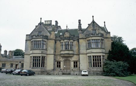
Moreby Hall [Grade II*]
Designed by Anthony Salvin in 1828 and completed five years later. It was Salvin’s second major country house commission in the Tudor style and built in sandstone from the Park Springs quarry near Leeds (Pevsner & Neave 1995, 713). The main house is a square block with symmetrical fronts north and south. Attached is a service wing arranged around a courtyard and linked to the main house by a conservatory on the southern side.
Lakeside Folly (Summerhouse) [Grade II]
Built around 1832, it is situated at the southern end of the pond. In a Gothic style, its windows are reputed to have come from York Minster following the fire there in 1829 (Pevsner & Neave 1995, 713).
Icehouse
To the north of the main house. Marked on the 1st edition Ordnance Survey 6” map (surveyed 1846/7) but may predate this.
Gardens and pleasure gardens
The following comes from the Heritage England listing [compiled in 1999] as the site has not been revisited:
The gardens and pleasure grounds are laid out around the Hall, along the west boundary of the site. Immediately north of the Hall is a square courtyard, with in the north-east corner an early C19 urn (listed grade II). Along the north boundary of the courtyard is a shrubbery, now (1999) overgrown, which contains the remains of an icehouse. From the north-west corner of the courtyard, steps lead down to a raised walk that runs along the west front of the Hall in a southerly direction. To the north, this walk is screened by an L-shaped castellated wall, with a porch that leads to a flight of steps that run down into the garden below. Halfway along the terrace a walk, called the Western Avenue, leads down into the lower garden to the west. The Western Avenue is flanked by mature yews, which were formerly clipped in various geometrical shapes, forming an arch (CL 1907).
The lower garden to the west is now (1999) laid out to lawn and is divided into various sunken garden compartments, which are screened by mature yews and shrubs. These are the remains of a formally laid out rosery, which is indicated on the OS 1st edition. Along the east side of the garden compartments runs a walk which is flanked by mature yews and trees and a set of urns (listed grade II). The walk leads southwards to another flight of steps, which leads to a serpentine pond surrounded by shrubs, now (1999) much overgrown. The pond is flanked to the east and west by a walk, and to its far south stands a gothic folly of c 1832 (listed grade II), probably C14 windows taken from York Minster after the fire of 1829.
Immediately south of the Hall is a balustraded terrace with two central steps which lead to the bowling green below (now, 1999, no longer used). The terrace has crazy paving and contains various circular and square beds. The steps and balustrade are decorated with six pairs of early C19 garden urns on pedestals (listed grade II). From the terrace there are extensive views over the bowling green and the parkland beyond it. The square-shaped bowling green is enclosed by clipped yews and surrounded by a walk. To the far south it is divided from the park by a low brick wall.
Kitchen garden
There must have been a kitchen garden associated with the second Moreby Hall belonging to the Lawsons. Its position and layout are unknown but a possible place is shown on Figure 2. There is an interesting news report from 1767, just after William Preston inherited the estate, perhaps indicating the skill of the gardener:
Last Week a Strawberry was pulled in Mr Preston’s Garden at Moorby, near this City [York], which measured four Inches round, and weighed nine Penny Weights and ten Grains [about 14g] (St. James's Chronicle or the British Evening Post, London, July 14, 1767 - July 16, 1767; Issue 994.)
The current walled kitchen garden is situated in the south-east corner of the site. It was constructed from 1828 to 1831 under the direction of the then head gardener, Thomas Deuxberry. There was a range of glasshouses (including a vinery) on the northern wall with two intersecting paths running north-south and east-west. In his letters, John Burr details some of the crops that he grows both for the estate and to be sold:
Some of our crops have been very good especially pines, grapes and peaches, others been thin. Gooseberries I think for the first time were scarce. We have had no apples nor indeed has anyone else. Pears we had a few and melons we have been less many with these. I think they are our greatest failures (U DDPR/50/24, 21st October 1838).
This year there has not been a peck of plums in the garden (U DDPR/50/44, 13th October 1839).
He seems though to have better success with pineapples as this report highlights:
Weight of Pine Apples—During the late sum[mer] Pine Apples have been cut at this place, the re. weights of which were 7 lbs. 4 oz., 8 lbs. 2 oz., 7 lbs. 8 oz., 9 lbs. 8 oz., and 10 lbs. 6 oz. lb average for each fruit of rather more than 8 lb avoirdupois (Gardener’s Chronicle 1842, 789).
Park and plantations
The park, which is laid out along the eastern boundary of the site, is level and contains various mature trees, mostly dating from the early to mid 19th century. Since the park is not surrounded by a tree belt, there are fine views into it from the B1222.
The area encompasses two previous areas of parkland (see Figure 2) adjacent to the first and second Moreby Halls. The large area of woodland called ‘Moreby Wood’ and ‘Moreby Far Wood’ that may well have been in situ since the Domesday book has been slowly reduced in size since the 1770s. Valuable timber has been cleared to convert the area to arable land, such as the sale of 1000 oak trees in 1829 (Yorkshire Gazette, 25 April 1829).
Water features
There is a pond (‘Fishpond’) in the western section of the park that was constructed around 1834 and another in the northern section near Moreby Bridge.
Books and articles
- Anon. 1907. ‘Moreby Hall, Yorkshire. The seat of Mr H. E. Preston’, Country Life, 16 February, 234-43.
- Baggs, A. P., Kent G. H. R. and Purdy, J. D. 'Stillingfleet', in Allison, K. J. ed. 1976. A History of the County of York East Riding: Volume 3, Ouse and Derwent Wapentake, and Part of Harthill Wapentake. London: Oxford University Press.
- Henrey, B. 1986. No ordinary gardener, Thomas Knowlton, 1691-1781.London: British Museum (Natural History).
- Heritage England, 1999. List entry for Moreby Hall park and garden, entry number 1001452 [https://historicengland.org.uk/listing/the-list/list-entry/1001452, accessed 25 August 2016]
- Leland, J. and Smith, L. T. 1909. The itinerary of John Leland in or about the years 1535-1543 (Volume 5). London: George Bell & Sons.
- Loudon, J. 1841. ‘Moreby Hall’ The Ladies' Magazine of Gardening, 361-2.
- Neave, S. 1991. Medieval Parks of East Yorkshire. Beverley, Hutton Press.
- Pevsner, N. and Neave, D. 1995. The Buildings of England: Yorkshire, York and the East Riding (2nd edn). London: Penguin.
- Raine, J. and Clay, J. W. 1865. Testamenta Eboracensia. Durham: Andrews & Co.
- Roebuck, P. 1976. Constable of Everingham estate correspondence 1726-1743. Leeds: Yorkshire Archaeological Society.
Newspapers & Magazines
- Gardener’s Chronicle
- Leeds Intelligencer
- St. James's Chronicle
- The York Herald
- Yorkshire Gazette
Primary sources
Borthwick Institute, University of York (BIHR)
- 1842 tithe map, TA 46S
- East Riding Archives (ERA)
- HD/33 - Diversion of Stillingfleet and Naburn highway in Stillingfleet (1829)
- HD/51 - Diversion of York-Stillingfleet highway in Naburn and Stillingfleet with Moreby (1844)
Hull History Centre (HHC)
- U DDBH/3/78 - IPM of John Acclam (1552)
- U DDEV/60/84-86 - Letters from Potts to Marmaduke Constable (1726-43)
- Papers of the Preston Family of Moreby Hall (U DDPR)
- /12/4 - IPM of George Lawson (1640)
- /12/9 - Exemplification of proceedings leading to a Final Concord (1598)
- /12/10 - Covenant to stand seised (1603)
- /12/12 - Exemplification of a Final Concord (1604)
- /12/18 - Schedule of deeds - estates of M Lawson (1680-1748)
- /12/19 - George Lawson marriage settlement (1680)
- /12/24 - Schedule of deeds of Marmaduke Lawson (1727-1754)
- /12/42 - Abstract of Title of Ralph Milbanke: farm at Mooreby (1697-1783)
- /12/50 - Lease and Release: Ralphe Milbanke to William Preston (1787)
- /12/51 - Final Concord for 'Manor of Moreby' (1788)
- /46/16 - Schedule of deeds - estates of M Lawson (1711 - 1760)
- /47/1 - Account Book Marmaduke Lawson (1718-1745)
- /47/6 - Bank books Henry Preston (1827-1833)
- /47/7 - Bank books Henry Preston (1833-1839)
- /47/8 - Bank books John Macvicar (1835-1836)
- /47/25 - Accounts of William Massey, timber merchant (1833-1841)
- /50/16 - Letter re work at Moreby (14 March 1831)
- /50/23 - Letters from John Macvicar steward (1837-1840)
- /50/24 - Letters and sketches of work at Moreby Hall (1839)
- /50/44 - Letter from John Burr re estate matters (1839)
Public Record Office (PRO)
- E 40/1360 - Deed of sale by John Wellisburne to Leonard Be[c]kwith, of Stillingfleit, co. York, of 4 meses, four tofts, and closes in Moreby, 12 February 1529
- C 2/Eliz/T3/51 - Talbot v Slingesby case, c1580
Maps
- Jeffrey’s map of Yorkshire, 1771
- Ordnance Survey 1st edition 6”, Surveyed 1846 to 1847, Published 1851

.")
 sheet 71, revised 1893, published 1898. National Library of Scotland CC-BY-NC-SA")