Oxton Hall park and garden is a largely intact early to mid-19th century designed landscape that takes advantage of its slightly elevated position compared to its surroundings (Figure 1). It was in an area that previously had been fields, so its location was presumably an important factor for the buildings and later grounds.
The Hall dates from the second half of the 18th century by an unknown architect and was owned by Mildred Bourchier until 1796, a wealthy widow. However it was the owner from 1806, John William Clough, who largely created the landscape we see today. The additions made by a subsequent owner, Admiral William Ramsden, in the mid-1850s further enhanced the estate. However the North Lodge and part of the parkland were separated from the main estate following the building of the A64 Tadcaster bypass in 1978.
Estate owners
Originally called ‘Mount Pleasant’, the mansion’s first known owner was Mrs Mildred Bourchier. She was the widow of John, the owner of Beningbrough Hall, north of York. On his death in 1759 and that of her only child the following year, she moved out of her main marital home to her property in York, Micklegate House. She acquired Mount Pleasant before 1784, when the accidental death of her gardener there, William Liddle, is recorded in the local parish records. Following Mrs Bourchier’s death in 1796 and by direction of her will (NA PROB 11/1289/192), the estate became the property of Peregrine Dealtry. He was the son of a York doctor, John Dealtry and it appears he was a friend rather than a relative of Mrs Bourchier.
By 1806, Dealtry had sold the estate to John William Clough as Philippa Brooksbank of nearby Healaugh Hall records in her diary that year – ‘28th Jul. Walked to see Mr. Clough’s house at Oxton’(THS 03-D-02). The Baines Directory of 1823 notes Clough as the occupier of ‘Oxton Hall’, although in 1824, it was still referred to as ‘Mount Pleasant’ in the 17th edition of Paterson’s roads (Mogg 1824, 283). The remodelling of the main house (NHLE entry No 1296566) is thought to date from Clough’s tenure and so it is conceivable that he was responsible for the other modifications to the estate by the time of the tithe map of 1845 (NA IR 30/43/314).
Clough sold the ‘Oxton House’ estate to Christopher Wilson in 1841, as the latter’s will written that year on the 29th November, refers to: ‘satisfying and discharging the purchase money and expenses of completing the purchase of a certain estate tithes and premises at Oxton in the said county of York for the purchase whereof I have lately contracted with John William Clough Esquire but which has not yet been conveyed’ (NA PROB 11/1968/388). Wilson died the following year and left Oxton to his wife, Sophia, for her lifetime and ‘after the decease of my said wife I give and devise and appoint the same estates and premises…to the use of and equally between my said nephews William Beckett and Christopher William Wilkinson’ (NA PROB 11/1968/388).
After Sophia’s death in 1848, Wilson’s nephews decided to sell the estate and it was bought by Admiral William Ramsden (2nd son of Sir James Ramsden 4th Bt of Byram Hall) for £24,000 (LULSC YAS MD290/6/2). In 1853 William Ramsden died and the estate was inherited first by his wife, Annabella and then in 1855 by his brother, Henry James. Henry Ramsden died on the 19th October 1871 and the following year the ‘Oxton Hall estate’ was put up for sale by his Trustees. It was bought by Alfred Harris.
Following Alfred Harris’s death on 11 April 1880, the estate was divided between his three daughters: Anna Jane Harris, Sophia Harris and Emily Busfield (d1881). The two unmarried sisters continue to live there until the death of Anna Jane on 26 October 1900 and the estate was sold to Isabella Anne Oliver (neé Ramsden, daughter of Henry James) the next year. Although Isabella died in 1908, her two sisters Louisa and Selina Ramsden continue to live there. With the death in 1918 of Selina, the last of the Ramsden sisters, the estate was once again put up for sale in 1919 (HEA SC01326). It was bought by Samuel Smith, who owned the local brewery at Tadcaster and the Oxton Hall estate remains in the possession of his family (Figure 1).
Key owners:
John William Clough (1806-1841)
William Ramsden (1848-1853)
Early history of the site
The Oxton Hall estate lies in the townships of Tadcaster East and Oxton (both in the parish of Tadcaster). The Percy family held lands at Tadcaster from the 11th century until the mid-19th century. In Oxton the owner listed in the Domesday Book is Osbern of Arques, with 4 carucates (about 480 acres of land) but there were no inhabitants (http://opendomesday.org/place/SE5043/oxton/, accessed 25 January 2017). This land passed onto the Percy family (Farrer and Clay 2013, 15) and was recorded in the Inquisition Post Mortem of Henry de Percy in 1292 (http://www.british-history.ac.uk/inquis-post-mortem/vol5/pp312-325 , accessed 25 January 2017).
In a survey of 1525, the Chantry of St John the Baptist of Tadcaster had ‘lands and tenements in Oxton, 36s to wit, for one messuage with 22 acres of land and a messuage with 8 acres of land there, 14s; for two cottages with orchard, 10s; in all 60s’ (Bogg 1904, 31). By about 1546, William Hyll (or Hill) is recorded as holding a messuage ‘with barn and garth lying within fields of Oxton, and payable to the King’s Majestie for a tenth, to Sir W Fairfax, to the city of York, to Spofford for suite of court, and Tadcaster for like suite’ (Bogg 1904, 35).
The Hill family appear to have been a major landowner by the end of the 18th century. Elizabeth Fletcher, granddaughter of William Hill (d1795), notes in her autobiography (Richardson 1874, 1) that her grandfather had ‘inherited a considerable estate [in Oxton], which had lineally descended to him from the time of Queen Elizabeth, his ancestor being a younger brother of the Hills of Marston’. Her father, Miles Dawson, was also a landowner there, being ‘descended from a respectable race of yeoman, his grandfather having purchased a small estate in the township of Oxton, in the time of Charles II, as appears by the title deeds’ (Richardson 1874, 1). Whether Mildred Bourchier bought the estate from either of these families or indeed from the Percy descendants is not known, nor whether she was responsible for the building of the mansion called ‘Mount Pleasant’.
William Hill had sought to buy all the tithes in Oxton in 1792 from John Woodyear of Crook Hill [near Conisbrough, South Yorkshire] with the exception of those belonging to Mildred Bourchier (WYAC RP/3:339). It is also noted in the same document that Mrs Bourchier had bought some tithes in Tadcaster East and lands belonging to her are shown in the Tadcaster Enclosure Award of 1798 (THS Map 1).
The mansion house of ‘Mount Pleasant’ is shown on the 1771 Jeffrey’s map but no owner is given nor any indication as to a designed landscape around it. There is more detail on the 1785 Francis White’s map of the Ainsty of York (Figure 2), showing Mrs Bourchier as the owner and a narrow strip of woodland on the boundary between the townships of Oxton and Tadcaster East.
Chronological history of the designed landscape
1806 – 1841
The tithe map of 1845 (NA IR 30/43/314) and the 1st edition 6” OS map (Figure 3), surveyed the following two years, are the first evidence we have of the designed landscape during the tenure of John William Clough. There is a small area of parkland (just over 27 acres) to the east and south of the hall, named ‘Oxton House’ at this time. Within this area are lines of trees that are remnants of previous field enclosures running parallel to the pattern of field boundaries seen to the east (Figure 3). A narrow strip of woodland ran round the park’s eastern edge. To the north, the area that was previously Tadcaster Common before its enclosure in 1798 (THS Map 1) was acquired by Clough and he created the plantation of ‘Fox Covert’ (just over 2 acres).
Around the house is an area of shrubbery (1.5 acres) and to north west of it, the walled kitchen garden (1 acre) with two buildings (probably greenhouses) on the northern wall. In addition, there is a pond and a lodge next to Oxton Lane. This road appears to have been moved south away from the Hall and there are plantations either side of it. At the time of the tithe award (November 1844), the section of woodland of one acre shown in the earlier maps to the east (‘Oxton Field Nursery’) belonged to Colonel George Wyndham (who inherited the Percy estates) and was occupied by Sophia Wilson.
There is also a drive that leads north from the house running northeast, then turning northwest to reach the York to Tadcaster road at The Slip Inn Farm. The label ‘Pindars Balk’ maybe referred to the embanked carriageway or the woodland belt.
1841 – 1872
The total land held by Christopher Wilson and his heirs in 1844 was 143 acres, with 99 acres in the Oxton township (NA IR 30/43/314 & NA IR 30/43/391). The extent of the designed landscape around Oxton House was about 42 acres. When it was put up for sale in 1872 (LULSC YAS MD290/6/3), the size of the total estate had increased to 167 acres (Figure 4), with about 79 acres described as ‘indispensable to the enjoyment of the Residence’ in the letter to the prospective purchaser, Alfred Harris (LULSC YAS MD290/6/2).
William Ramsden is said to have spent £3000 in ‘additional buildings and permanent improvements’, together with the acquisition of more land (LULSC YAS MD290/6/2). This included increasing the existing parkland to nearly 56 acres to the west and north and adding a second Lodge off the main York to Tadcaster road with accompanying carriage drive. He also increased the size of the plantations as the letter indicates: ‘the plantations are young and thriving, planted principally about 25 years ago’ (LULSC YAS MD290/6/2).
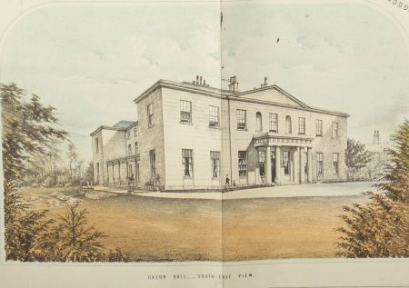
Around the house to the south west were new pleasure grounds and below the south front of the house a terraced parterre garden shown on the painting of the Hall included on the plan (Figure 5). The kitchen garden had an additional glasshouse on the south wall and the interior was now laid out with circular paths (Figure 4).
Later history
By the early 1890s and the publication of the 1st edition 25” OS map, little had changed in the designed landscape. By 1908, the second edition of the 25” map showed three additional freestanding greenhouses to the north of the walled garden. On the terraced garden below the south front, there was now a fountain.
By the time of the sale in 1919 (HEA SC01326), the mansion, park and pleasure grounds amounted to just under 61 acres. The description is as follows:
The Park and Pleasure Grounds are fully matured, and studded with choice specimen trees in variety and wealth of timber…The East and West Sides of the Park are partly sheltered by Plantation Belts.
The Pleasure Grounds, situate on the South Front of the House, are undulating, shaded by various Cedars, Cupresses and other trees, while the Lawn is intersected by winding gravel paths. Pond and Rock Garden.
On the South-West of the House is the Conservatory, Pigeon House, Rustic Summer House, Flower Beds, Rose Garden with pergolas, and, immediately in front of the Verandah, are additional Flower Beds cut in geometric patterns. The Upper Lawn is terraced and relieved by a Water Fountain, and the Lower Terrace provides the Tennis or Croquet Lawn screened by a Wooded Walk.
In 1978, the Tadcaster bypass of the A64 was built through the northern and eastern part of the estate. This meant the separation of the North Lodge and its surrounding woodland from the rest of the site.
Location
Oxton Hall lies just over ½ mile (1km) east of Tadcaster and 8 miles (13km) south west of York.
Area
The mansion, gardens and historic parkland covered an area of 79 acres (Figure 6).
Boundaries
The historic northern boundary was the York to Tadcaster Road from the former North Lodge to Tadcaster Bar. The western boundary followed the historic division between the townships of Tadcaster East and Oxton from the main road to just south of Oxton Lane. The southern extent of the designed landscape included the plantations on the south side of Oxton Lane and then to the north of it to SE 498433. The eastern boundary continued north from Oxton Lane until SE 500436, with a section further west lined with a plantation from SE 502436 to SE 503438.
Landform
The site of the main mansion and immediate grounds is at 20m AOD, a slightly elevated position compared to its surroundings. The land slopes down to the south towards Oxton Lane and to the east to Oxton village. The underlying geology is calcareous mudstone (Croxby Formation), overlain by glacial tills and part of the Escrick Moraine. Here the slightly acid, loamy and clayey soils have impeded drainage and so the majority of the land was used for pasture. This was noted in the 1872 report (LULSC YAS MD290/6/2): ‘excellent, however, as the grass land is, the greater proportion of it requires efficiently draining’.
Setting
The slightly elevated site possibly gave rise to its original name of ‘Mount Pleasant’. From the mansion, there would have been views down to Oxton Lane and possibly the River Wharfe to the south of it. The main view east, where the park is located, would have been towards the hamlet of Oxton. The plantation belts to the west would have afforded privacy from the public toll road towards Tadcaster, as would the woods around the North Lodge.
Entrances and approaches
South Lodge
It was built before 1845 and accessed from Oxton Lane, the road from Tadcaster. William Waddington, the gardener, was recorded as the occupier in the tithe award (NA IR 30/43/314). However it only appears to have become an entrance when a new carriageway is built between 1872 and 1894 from it to the house.
North Lodge
It was built between 1848 and 1872 when the parkland was extended to the north. It was next to the main York-Tadcaster road. From ‘neat Entrance Gates’ a carriageway went south to the Hall (LULSC YAS MD290/6/2).
Southern entrance
This is off Oxton Lane at SE 498433 and was the main carriageway prior to the North Lodge being built. It runs northwest towards just north of the Hall.
Western entrance
Off the main York to Tadcaster road, it runs past Slip Inn Farm east and then south towards the Hall. It was in place before 1844.
Principal buildings
Oxton Hall [Listed Grade II]
Built before 1771 and possibly in the 1st half of the 18th century (NHLE entry No 1296566), it was later remodelled in the early 19th century.
Gardens and pleasure grounds
The terraced parterre garden to the south of the Hall is shown on the sale map of 1872 but may well date to the 1840s or earlier. It was still in-situ by 1919, although the design may have changed to reflect a change in garden styles and the addition of the fountain after 1892.
There were shrubberies listed around the house and kitchen garden in 1844 (tithe award) and further pleasure grounds replaced the paddock next to the South Lodge [also Gardener’s Cottage] by 1872.
Kitchen garden
The walled kitchen garden covers one acre and could date from the late 18th century during the tenure of Mrs Bourchier. However the present structure was built by 1844, with the earliest greenhouses on the northern wall. In 1828, William Thompson, gardener to JW Clough had won 1st prize for melons at Yorkshire Horticultural Society (Loudon’s Gardeners Magazine, Vol 4, 517), although these could be grown in separate ‘melon pits’.
By time of the sale in 1919 (SC01326), the kitchen garden was:
‘divided into two sections with hard gravel paths, contains matured espalier and wall Fruit Trees. There are two Orchards.
The Range of Glasshouses comprise:-
Vinery 97ft 0in by 8ft 3in (heated) Vinery 32ft 9in by 15ft 6in (heated) Peach House 32ft 9in by 12ft 3in (heated) Peach House 35ft 10in by 12ft 3in (cool) Greenhouse 29ft 3in by 13ft 0in (cool) Cucumber or Melon House 32ft 6in by 13ft 0in (heated) Carnation House 15ft 0in by 10ft 0in (heated) Additional Buildings consist of Mushroom House, Potting Shed, Stoke Hole with boiler, Fruit Room, Pot House and Bothy’
Park and plantations
The main area of parkland to the east of the Hall appears to have been created in the early 19 century by the opening up of previous enclosed field strips, as remnants of field boundaries still existed by 1845. During the medieval period the area was ploughed and cultivated as most of the parkland retains earthworks of ridge and furrow.
Around the perimeter of the park to the east and west were belts of trees. There was a significant area of woodland in the northern section that encompassed the earlier ‘Fox Covert’ plantation.
Water
A small pond lies to the southwest of the Hall north of Oxton Lane, dating from before 1845 and labelled ‘Fish Pond’ on 1892 25” Ordnance Survey map.
Books and articles
Bogg, E. 1904. Two thousand miles in Wharfedale. London: Heywood.
Farrer, W. and Clay, C. T. 2013. Early Yorkshire Charters, Volume 11: the Percy Fee. Cambridge: Cambridge University Press.
Mogg, E. 1824. Paterson’s Roads 17th edition. London: Longman & Co.
Richardson, M. ed. 1874. Autobiography of Mrs Fletcher of Edinburgh. Carlisle: C. Thurnham & Sons.
Primary sources
Historic England Archives (HEA)
SC01326 The Oxton Hall Estate sale particulars, 15 July 1919
Leeds University Library Special Collections (LULSC)
Archaeological & Historical Society Collection (YAS)
MD290/6/2 Letter to Alfred Harris Esq. of Sleningford Park Ripon from John Eddison, Valuer 25 Park Square Leeds containing valuation & description of Oxton Hall Estate Tadcaster 29 April 1872
MD290/6/3 Sale Catalogue for Oxton Hall with park, pleasure grounds & farm lands for sale by auction by Messrs Hepper & Sons at the Royal Station Hotel York on 1st May 1872
National Archives (NA)
PROB 11/1289/192 Will of Mildred Bourchier, proved 24 April 1797
PROB 11/1968/388 Will of Christopher Wilson, 29 November 1841
IR 30/43/314 Tithe map and award of Oxton, 1845
IR 30/43/391 Tithe map and award of Tadcaster East, 1841
Tadcaster Historical Society (THS)
Map 1 Reconstructed Enclosure Award Map for Tadcaster 1798
03-D-02 Diary of Philippa Brooksbank [there is an online version at
http://paulfiddian.co.uk/documents/The%20Diary%20of%20Philippa%20Brooksbank.htm accessed 16 February 2017]
West Yorkshire Archives, Calderdale (WYAC)
RP/3:339 Letter from William Hill, The Grange, (?Oxton by Tadcaster) to Robert Parker
Maps
Jeffrey’s map of Yorkshire, 1771
Francis White’s map of the Ainsty of Yorkshire, 1785
Ordnance Survey 6” 1st edition, surveyed 1846 to 1847, published 1849
Ordnance Survey 6” 2nd edition, surveyed 1891, published 1894
Ordnance Survey 6”, surveyed 1906, published 1909
Ordnance Survey 25”, published 1892 & 1908
Figure 1 – Oxton Hall estate. Google 31/12/2005, image © 2016 Getmapping plc
Figure 2 – Location of Mount Pleasant. Francis White’s map of the Ainsty of York, 1785 showing location of ‘Mount Pleasant’
Figure 3 – Oxton House park and gardens. 1st edition 6” OS map, surveyed 1846 to 1847, published 1849. Reproduced by permission of the National Library of Scotland
Figure 4 – 1872 sale plan (LULSC YAS MD290/6/3). Reproduced with the permission of Special Collections, Leeds University Library
Figure 5 – Drawing of Hall and garden from 1872 sale plan (LULSC YAS MD290/6/3). Reproduced with the permission of Special Collections, Leeds University Library
Figure 6 – Oxton Hall estate. 6” Ordnance Survey map surveyed 1906 and published 1909. Reproduced by permission of the National Library of Scotland.


.")
.")
