Sutton Park is the site of an Elizabethan manor house that was acquired by the Harland family in the early 17th century. A new hall was built in the mid-18th century, with involvement of Thomas Atkinson and plasterwork attributed to Cortese. An undated plan (c. 1784-1801) by the landscape designer, Adam Mickle II, detailed proposed alterations to the grounds and park, although current evidence suggests that his proposals were not carried out. The parkland and pleasure grounds were probably laid out in the early 19th century and remain essentially intact. Surviving structures include two terraces of the formal garden, a walled garden and an icehouse.
Estate owners
The mediaeval manor passed through several hands before its acquisition by the Crown in the reign of Richard III remaining a royal property until the early 1600s. Humphrey Barwick, a retired soldier, purchased or leased land in the 1580s and built a house on the site.
In 1618 Richard Harland obtained a lease on the property and acquired it outright some time later. His support for the Royalist cause in the Civil War resulted in the loss of the property, but his rights were restored after 1660. Indentures of 1666 and 1668 show that Richard settled land at Sutton on his son Thomas and the mansion at Sutton and land on his son John. Richard and his two sons also bought up land and property in Sutton and Huby to enlarge the estate. Richard died in 1689. His younger son John was trained as a lawyer and had a practice in York, where he also lived, so he may never have lived at Sutton.
In 1701 John made over the mansion at Sutton and land to his son Richard, in exchange for annuities for himself, his wife and daughters. Richard was in London, where he first studied the law and subsequently practiced. Possibly because the mansion at Sutton was not being occupied by the family, it was rented out in 1702 to Sir Hugh Smithson for an unknown period. In 1704 Richard married and the estate at Sutton was formally settled upon him by John.
Richard died in 1750 and in his Will he clarified the order of succession under the terms of the entail set up by his father John. His first son Philip inherited the property at Sutton, to be followed by any sons of his, and failing that, by his half-brothers in order of birth. When Philip died, his only children were two daughters Elizabeth and Anne, neither of whom could inherit the estate while male relatives were still living. However, they would become entitled to receive rental income from some properties on the death of their mother if they were unmarried. The estate first passed to Philip’s half-brother John. He was succeeded in 1772 by his half-brother Richard, who appears to have been handicapped in some way, and apparently not capable of managing his affairs. Richard died in 1784 and was succeeded by his brother Charles, who died only a few months after inheriting the estate.
By 1784, the only Harlands still alive were Philip’s daughter Anne and John’s daughter Ann. As the daughter of the eldest son Philip, Anne (1745-1826) inherited under the terms of a legal decision in 1782. She had married the Rev Henry Goodricke, who was a member of the Goodricke family of Ribston Hall near Wetherby. He already had income from his family estate and from several church livings. A major interest in his life appears to have been horse breeding and racing: his horses won the St Leger four times. Henry effectively controlled Anne’s interest in the estate.
Anne remained at Sutton Hall until her death in 1826. After the death of Henry Goodricke in 1801, it seems she took an active part in the management of the estate, as correspondence regarding the lease on Sutton Grange Farm with the Lords Commissioners of his Majesty’s Treasury reveals. She also remarried in 1802 and her new husband, Charles Hoar, added her name, Harland, to his.
Charles was knighted in 1808, but died in 1810. Anne had no children with either husband, so her later years involved legal action on her own account, and with other interested parties, to secure the inheritance. The situation was complicated by the fact that part of the estate had been left to Anne’s elder sister Elizabeth, who had bequeathed her share to her sister for her lifetime and then to her godson, the Rev. O. W. Kilvington. Anne left her share of the estate to William Hoar, the brother of Charles Hoar, but by the time she died in 1826 he had already died, so the estate came to his son William Charles Hoar. He took the surname of Hoar Harland.
The precise terms of W. C. Hoar Harland’s inheritance appear not have been settled until 1827, but he gained control of the bulk of the estate. He was an MP for the City of Durham from 1832 to 1841 and married Catherine Duncombe Shafto. He died in 1863, childless, and bequeathed the estate to his wife’s family, specifically Admiral Duncombe. The Admiral passed the estate to his second son Arthur Duncombe shortly afterwards. Arthur Duncombe took the name Grey in order to enable his wife to benefit from another inheritance.
Arthur Grey died in 1911, leaving a substantial estate at Sutton in trust for his wife. She took out mortgages on some of the farms, possibly to pay death duties, and then sold these farms and some other properties in the early 1920s to pay off the mortgages before she died. After her death in 1926, her daughter Lady M K de Yarburgh Bateson inherited the estate, and immediately began to sell off the properties in the village.
At some stage the estate became a limited company and the Hall was probably rented out. During the Second World War the Hall was occupied by officers of the Royal Canadian Air Force who operated from the airfield directly to the east of the Hall. The grounds were used for drills and training of the Home Guard. Following the death of Lady de Yarburgh Bateson in 1960, the estate, now consisting of the Hall, various outbuildings, the gardens, parkland and woodland, and five farms, totalling 1,086 acres, was sold by Mr G K Galliers-Pratt and Sutton Hall Estates Ltd to E C Reginald Sheffield of Normanby Hall in 1962.
The estate remains in the ownership of the Sheffield family.
Key owners responsible for major developments of the designed landscape and dates of their involvement:
Richard Harland b 1592 (1618-1689)
Richard Harland b 1675 (1701-1750)
Philip Harland b 1707 (1750-1766)
John Harland b 1727 (1766-1772)
Anne Hoar Harland b 1745 (1784-1826)
William Charles Hoar Harland b 1804 (1826-1863)
Arthur Grey (né Duncombe) b 1840 (1864-1911)
Sheffield family (1963- )
Early history of the site
The parish of Sutton-on-the-Forest stands in the area of the former royal forest of Galtres. Camden writing in the late 16th century observed that ‘the land in this part of the royal forest was flat, wet and boggy, but was well wooded in the eastern half of the parish’ (VCH 1923). By this time the medieval manor house, on the site of the later Hall, was described as ‘an old house with three or four rooms in it, decayed. The old house was covered with thatch’ (NA LR2/231). Humphrey Barwick obtained a long lease from the Crown in the late 16th century and built ‘a mansyon house having one hall...twoe chambers over the same, one garner over the chambers at the west end of the house, one little chamber next the greate chamber, one little gallerye, twoe little chambers over the kitchinge, a little chamber on the southe side, a buttery at the west end of the house, a kitchen, a larder house’ (NA LR2/231). There was a garden, an orchard and a dovecote. This house was sometimes referred to as ‘Sixhouses’ in deeds and other legal documents and the Hearth Tax records of 1673 confirm that there were six hearths, a relatively modest establishment.
Richard Harland obtained a lease for the Hall in 1618. He fought for the Royalist side, was briefly imprisoned and fined heavily enough to have to mortgage the estate. The estate was restored to him after 1660, and he also was given control of New Park, a former royal hunting lodge near Huby, 2 miles to the west of Sutton. Both Sutton Hall and New Park were said to be in poor condition following the billeting of Parliamentary troops at both properties after 1644 (VCH 1923).
Chronological history of the designed landscape
1701 – 1784
Richard Harland (1675-1750) purchased the farm called Bohemia and 375 acres in 1705, the parsonage, rectory and glebe, the tithes, the church at Sutton and various rights in 1708, and the land owned by his cousin the same year. He also made other purchases of cottages, strips of land in the open fields and other small parcels of land in the village in the early 1700s (YCLA WSC/2/34, box 28). Philip Harland bought more land, first on his father’s behalf from the 1730s, and later in his own right. Sutton was the subject of an enclosure act in 1756 with the land awarded three years later (NYCRO NRRD AL no 33).
Philip's brother John Harland was much involved in the building of the York to Oswaldkirk turnpike road from about 1766. Once permission for the road had been obtained in 1768, he agreed to be responsible for the construction of the road through Sutton. An undated map of the village (c. 1766-1771) (NYCRO ZDV VI 48) shows the site of a toll booth on the village street, the village green and pond to the west of the house and a row of cottages to the south of the village green (Figure 1). This plan shows only the boundary wall around the Harland property and house. Jeffrey's map of c. 1771 (Figure 2) shows the partially constructed turnpike road running north from York, meeting the village street and bending east through the village. The row of cottages to the south is no longer there. The village green and pond are not shown and the land where they were sited appears to have been enclosed within the boundary of the Harlands’ grounds.
1784 – 1826
Henry Goodricke commissioned Adam Mickle II to draw up a proposal for alterations at Sutton Park. The plan is undated but was drawn up between 1784 when Henry and Anne gained control of the estate and 1801, when Henry died. Parts of the areas shown on the plan could have already been in place but without an earlier contemporary estate map, it is impossible to verify. On the undated map of the village (NYCRO ZDV VI 48, Figure 1), the area that becomes the walled garden on Mickle’s plan (Figure 3) and on the 1st edition OS map, surveyed 1851/2 (Figure 4), was part of the village with houses, green(?) and pond. It is in an odd position for a walled garden as the north wall backs onto the street, thereby making it impossible for these to be used as hot walls. Instead the flues for heating the walls were situated on the southern wall. The fruit was therefore grown outside the walled structure (where glasshouses were later installed), and lost the benefit of being inside the walled area. The former village pond also takes a large part out of the productive area. So perhaps the wall, having been built to mitigate the impact of the new turnpike road on the property, was already in existence when Mickle was asked to prepare the plan and he tried to ‘improve’ the enclosed space by creating an interesting area around the pond.
Outside the walled garden to the east, Mickle designed a large open area with a drive coming from the east side and sweeping round to the Hall entrance (Figure 5). However the entrance shown on 1st edition OS map is a straight avenue and is possibly a remnant of earlier landscaping as this was a common design for an approach to houses in the early 18th century. In this area, next to the walled garden, Mickle put a summerhouse. This is approximately where the icehouse is currently sited, so the summerhouse was either not built or demolished. The stables are shown as a single block fronted by a yard. Beyond the shelter belt of trees that protect the house to the east, there is a pencilled notation for an orchard.
The western section of the pleasure grounds surrounded the second proposed entrance just before the Gardener’s cottage and the second carriageway (Figure 6). The southern boundary of this was to be protected by a ha-ha. None of these features appear on later maps. There are pleasure grounds here with a greenhouse as a central feature by 1851/2, including the area left blank on the plan. While there are further gardens to the east shown later, they do not match exactly the areas shown by Mickle.
Apart from a small area of woodland to the east, the main area of parkland is sparsely planted and the focus of it is the carriageway from the south on the plan. This starts from the York road where it starts to curve to the west and is presumably the new section built for the turnpike. Succeeding maps show no entrance from this point and the later path (or route?) through the park is further east. The planting along the York road is in clumps rather than the long shelterbelts shown later but the latter could have developed from the former. A summerhouse (that no longer exists) was built at the end of a walk south next to the York Road.
There is no documentary evidence to reveal what changes Henry and Anne made to the pleasure gardens and grounds during Henry's lifetime. However, correspondence in 1808 indicates that Charles Hoar Harland, Anne's second husband, was considering the purchase of three fields in order to extend ‘The Lawn’ (YCLA WSC/2/34 Acc 388/63). He talks of ‘the pleasure I have in improving this place’ and his desire to purchase ‘three fields, separated from the Lawn by a fence only’. A deed of sale to William Hoar by Anne Harland and the Rev Henry Kilvington dated 7 December 1820, refers to ‘a mansion house, courtyard, stables, garden, orchard, pleasure ground, plantation currently in the occupation of Anne Harland’ plus ‘The Lawn’ of 40 acres 3 roods and 30 perches ‘formerly in several parts’ (NYCRO ZUA).
1827-1911
The Mickle plan covered an area significantly smaller than the 150 acres of parkland shown on the 1st edition OS map, so even if it was implemented at the time then further work was done to the designed landscape. The unenclosed land between the pleasure grounds of the house and the Home Farm is noted as ‘The Park’ on the OS map (Figure 4), but it is not clear which areas are parkland and which are agricultural land. The area extends from the gardens south along the boundary with the road within a belt of trees beyond the Home Farm to a field boundary running east-west parallel with Southfield House, then turns south, east and north again to run along the western side of Southfield House then north along field boundaries to meet a long shelter belt of trees south east of the Hall. There are enclosed fields and a patch of woodland on the eastern side.
In the walled garden, there are irregular paths and the pond. The area to the south of this has planting, a hotbed, a greenhouse and pump. There are two structures marked on the OS map on the east wall of this garden. Although neither are named, one may be the icehouse. The stables now have two south-facing wings and there are other outbuildings southwest of the stables. There are formal gardens, consisting of two terraces and a fountain to the south of the house, but no evidence of the ha-ha proposed by Mickle.
An orchard is shown on the OS map to the southwest of the stables, in approximately the same area as that indicated on the Mickle plan. There are two unidentified small structures in woodland to the south and south east of the orchard. A walk, later called ‘The Long walk’, runs parallel to the main road north into the village in the plantation belt to just north of Home Farm.
The Census records from 1841 onwards indicate that William Charles Harland employed a number of gardeners. In 1851 William Campbell was head gardener, followed in 1871 by his son, also named William, who had then become Arthur Duncombe's head gardener.
By 1891, the only changes were a slight remodelling of the northern entrance with paths encircling the open areas east and west of the central drive (Figure 7) and changes to the walled garden. It now had formal paths around the walls inside the garden and formal paths crossing the garden centred on the pond. On the southern wall was a more extensive range of glasshouses. By 1909, the greenhouse south of the walled garden had gone (Figure 8).
Later history
A Deed of 23 March 1962 (NYCRO, Vol 1577 p117 no. 53), includes a map of the estate and a detailed schedule. In this schedule, the Hall, pleasure gardens and park amount to 9.883 acres, and the area containing the various offices, lodge, cottages and other outbuildings amount to a further 40.967 acres.
The formal gardens and other features that remain today are the work of Peter Coates and Percy Cane for the Sheffields, commencing in the 1960s. The garden writer and horticulturalist Arthur Hellyer in his book (1980) considers that although Percy Cane did not produce detailed plans, he visited the Sheffields several times and made suggestions which the Sheffields pursued. Hellyer also mentions that the Sheffields created a new woodland walk around part of the parkland, in which they installed a little temple summerhouse in the south-eastern corner.
In the late 1990s, the Sheffield family produced a booklet for visitors, which reproduces an article written by Nancie Sheffield on the development of the gardens, in which she confirms that the two upper terraces on the south side of the house depicted in 1893 were present when Major Sheffield purchased the estate in 1962. The Sheffields then created a third terrace by including a portion of the park to lay out the long canal garden below the house and divided the garden from the park by planting a beech hedge. The top terrace outside the library was paved with flagstones from the kitchens of old houses in Otley, and on the second terrace there is a large ancient wellhead which came from Normanby Park.
Location
Sutton Hall is situated in the Vale of York, 8 km north of the city of York. It lies in the village of Sutton-on-the-Forest on the B1363 York to Helmsley road.
Area
The historic parkland at its greatest extent (c. 1912) comprises 59 hectares (146 acres) consisting of the pleasure gardens (4 ha, 10 a.) and immediate grounds (16.5 ha, 41 a.) and open parkland including woodland and boundary plantations (38 ha, 95 a.).
Boundaries
The boundaries of the gardens and grounds are: starting at the north, the former turnpike road, now the B1363, through the village as far as the entrance to the stable yard near the Black Swan public house. It runs south and east along a belt of trees, then due south alongside a track down to Southfield House, south along the field boundary, then west to Crow Nest Clump, north along a track and field boundary to a track running eastwest, then west to a field boundary south of Home Farm, along the eastern edge of Home Farm heading north to meet the line of trees adjoining the B1363 and continuing north to form the western boundary up to the village street.
Landform
The underlying bedrock geology is the Mercia Mudstone Group and is overlain with alluvial sandy deposits. The soil is naturally wet, very acid, sandy and loamy with low fertility.
Setting
The parkland is situated on former moorland to the north of York which is known as the Forest of Galtres. The estate is surrounded by farmland, arable and pasture and some woodland. The landscape is described in the North Yorkshire Landscape Character Assessment (2011) under landscape classification no 28: vale farmland with plantation woodland and heathland. The land is generally flat with the Hall slightly raised at 30m AOD and the surrounding gardens at 28-29m AOD. The ground then falls away south towards the southern boundary of the parkland at about 21m AOD.
Entrances and approaches
Gatepiers from Main Street, Sutton-on-the-Forest village.
Brick built, topped by stone urns. Linked by ornamental wrought iron gates framing the main entrance to the house.
A second entrance forms a service entrance to the stables, estate offices etc from Main Street.
It is first depicted on 1st OS 1856 to the east of the stable block.
Garden entrance from B1363 to the west of Sutton Hall.
It is shown as an entrance on the Mickle plan and may predate it. Depicted on all subsequent maps and still extant. It is formed by two brick piers of the same height as the wall (3m) and topped with flatstone coping. Solid wooden double gates.
Principal buildings
Sutton Hall (Grade I, NHLE 1260322)
The Hall is listed Grade I by Historic England as a 'Country House 1730-1740, altered by Thomas Atkinson for Philip Harland'. Pevsner considers that it was 'built sometime between 1750 and 1754' after Philip Harland inherited the estate on the death of his father in 1750. His father's will contained a clause providing £500 ‘in case my first son shall think proper to build a new house at Sutton or in any proportion repair the old mansion house at Sutton, I give him power in case he dies without such issue as the same is limited unto him to charge the said estate at Sutton with the sum of £500 and if he thinks fit to lay out the same’.
Thomas Atkinson was baptised in 1729, the son of a stonemason and died in 1798. His first known architectural plans date from 1758-9, and the plan for the north front of Bishopthorpe Palace dates from 1766-9. No plans appear to exist for Sutton Hall. The ceiling in the entrance hall is attributed to the plasterer Cortese. It is known that Cortese and Thomas Atkinson worked together, notably at Burton Constable. Therefore the work on the house at Sutton must have been completed by 1778 the year of Cortese's death.
A further possibility, as suggested by Lady Nancie Sheffield (Hillery, 1980), is that Thomas Atkinson could have been involved at a later date as the architect of the wings, working for Henry Goodricke.
Stables (Grade II, NHLE 1241743)
The stables lie to the east of the hall. Shown as a rectangular block on the Mickle plan, subsequently altered with additional two wings, open to the south, as shown on 1856 OS map. Now converted to form garages and accommodation.
Icehouse (Grade II, NHLE 1241815; Historic England Scheduling No 1018854)
The icehouse is not easy to date. Two entries in the Historic England listings propose either a mid-19th century date or a date of 1730. There is no evidence of an existing or proposed ice house anywhere on the Mickle plan. The present location of the icehouse appears to coincide with the site where Mickle proposed a summerhouse should be built. The 1856 OS map shows an unnamed structure in that location. The ice house is built against the east wall of the walled garden on a prominent mound.
Gardens and pleasure grounds
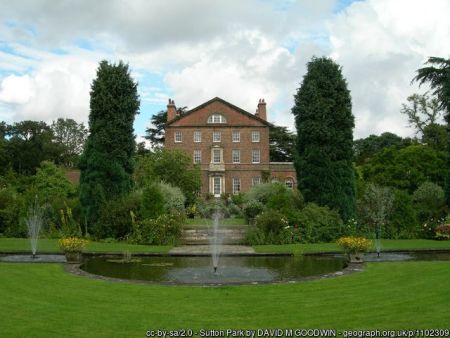
There are terraced gardens to the south of the Hall, the upper two shown on the 1856 OS map. A further terrace below, on which the canal pond was created, dates from the 1960s. At this time the garden was extended by taking in a portion of the park and separating it by planting a beech hedge. At each end of the top terrace gazebos support roses and clematis, the borders focus on scented plants. On the second terrace there is a large ancient stone well head from Normanby Park, roses and herbaceous plants. The third terrace has a formal water garden with a fountain. To the east, there stands a large liriodendron tulipiferia planted by Prince George on 27 October 1903 beyond which a semi-wild glade leads to the Temple Walk. This heads south along the eastern side of the open parkland and features a small temple or summerhouse. Near the house to the west, a fernery has been created on the site of the old Edwardian rock garden by Sir Reginald Sheffield: it is planted with ferns, hostas and palms. To the west, a lawned area with mature specimen trees (such as Cedar of Lebanon) leads to the Long Walk through a plantation which follows the western boundary. The 1856 OS map indicates a summerhouse at the end of the Long Walk which is no longer present.
Kitchen garden (Walls listed Grade II, NHLE 1260370)
The walls are of red brick, Flemish bond, 3m in height with flatstone coping. There are stepped brick pilasters around the perimeter. On the south wall there is evidence of heated wall flues. There are also three entrances. The ice house lies behind the east wall just the north of centre. Further north along this wall, there is evidence of a blocked brick doorway with remaining quoin stones in the wall fabric.
The mid-eighteenth century village plan shows the village green and duckpond to the west of the house outside the boundary of Sutton Hall. The Mickle plan depicts a walled area to the west of the house within the boundary walls, seemingly on the site of the green and incorporating the pond. This has a formal layout, with a path around the walls and a central path. The western half of the garden forms two quadrants, the eastern half is divided into three sections. The largest, middle section contains a pond, surrounded by formal planting and a walkway. There are two proposed entry points to this garden. One via a sinuous path through woodland passing the site of a proposed summerhouse leads to a doorway close to the northern boundary. The second is via a path leading to the south side of the garden with an entrance in the eastern corner. This entrance survives although the northern doorway appears to have been bricked in.
The 1856 OS map shows a less formal layout with orchard planting and some structures on the south wall on both sides. To the south, a freestanding hotbed is indicated. By 1909, the internal layout of the walled area is once again laid out with formal paths: there is no evidence of fruit trees. A long range of structures lies along the north face of the south wall. The structures within the walled garden do not survive but there is evidence of the flues that once heated the walls and of whitewashed walls. Today, the walled garden contains a small orchard area, some trained fruit trees and the rest is lawned.
To the south of the walled garden, by 1911, there appears to be a new area of garden bounded by a wall on the east and south sides with a path running along the middle. On the south face of the south wall there is an extensive range of greenhouses over most of its length. A further greenhouse has been erected on the eastern side of the west wall alongside the road and the hotbeds seem to have been enlarged. Today, the greenhouses have been partly dismantled and there is one freestanding hotbed remaining. The area is still being cultivated for cut flowers and vegetables.
Park and plantations
Open parkland
The Mickle plan proposed a ha-ha to the south of the house with open parkland stretching south. A drive ran from the house diagonally down to a new entrance on the Turnpike road. Three large clumps of trees appeared on the boundary to the west, shelter belts to the north-east, east and south and small scatters of trees within the park. This may be the area of c. 40 acres referred to as The Lawn in documents dated 1808 and 1820 (NYCRO ZUA). There is no evidence of the implementation of the ha-ha or avenue. By 1851/2, the OS map shows a shaded area named Sutton Park, considerably expanded to the south and east, covering c. 130 acres. The open parkland area is slightly reduced on the 1912 OS by the loss of two fields north of Southfield House. Several clumps of trees depicted on the OS maps survive. In the 20th century a large area to the east of the parkland has been planted with trees in conjunction with the Forestry Commission and the Yorkshire Wildlife Trust. The Temple Walk now runs through this.
Plantations
The layout of the plantations remains essentially as mapped in the 19th century. On the western side of the park a continuous narrow belt of trees runs south from the house down to the Home Farm. Half way down, the map indicates a summerhouse. In 1891 the path running through the belt of trees is named as the Long Walk but the summerhouse is not present. Within the parkland the major feature is the presence of five large clumps of trees. The area of woodland to the east appears to have been implemented in the 20th century.
Water
Walled Garden pond
It first appears on the Village Plan (NYCRO ZDV VI 48) outside the boundary of the Harlands’ property, surrounded on three sides by cottages. The Mickle plan shows a pond divided from the village by the north and west walls along the Turnpike Road. The plan suggests ornamental planting around the pond and sinuous paths. The pond is shown on later OS maps and remains a feature of the Walled Garden to the present day.
The Canal pond
Also known as the Lily Pond, this was created in the 1960s on what became the third terrace below the Hall. It is a simple elongated rectangle broken by a semi-circular bulge on the south side to match the curve of the boundary hedge beyond. The pool has a fountain and some planting of water lily pads. The position of this pond, in direct sunlight, may be one of the features that reflect the influence of Percy Crane on the design of the garden.
Parkland ponds
During the present family ownership, a woodland walk has been created which passes two small ponds on the eastern side of the parkland. These ponds do not appear on historical maps.
Books and articles
Bulmer 1890. History and Directory of the North Riding. www.genuki.org.uk
Colvin, H. 1995. A Biographical Dictionary of British Architects 1600-1840. Paul Mellon Centre for Studies in British Art. Yale University Press
Hellyer, A. 1980. Gardens of Genius. London, Hamlyn.
Hillery, C. (n.d.) Gardens of the North, Discovery Guide, Middleton in Teesdale
Mennim, E. 1997. The Harland Monuments at All Hallows Church Sutton on the Forest, York. Croft Press.
Perry, J. 1977. The York to Oswaldkirk Turnpike Trust 1768-1881. NYCRO Publications: Northallerton
Pevsner, N. 1966. Yorkshire: The North Riding, The Buildings of England. Harmondsworth, Penguin Books.
Sheffield, N. 1985 'Sutton Park' in Lees-Milne, A. (ed.) The Englishwoman's House. Fontana (Collins)
Sutton Park, Stately Home (n.d.), Visitor's Guidebook
Victoria County History. 1923. A History of the County of York, North Riding. Vol 2. London
Primary sources
York City Library Archive (YCLA)
WSC2/34 Wares Solicitors Collection/Harland 1534-1867
North Yorkshire County Record Office (NYCRO)
CRONT 1454 Hearth Tax Records 1673, Wapentake of Bulmer, Sutton in Galtres
Vol 1577 p117 no. 53 Deed of the estate, 23 March 1962
ZDV (I) Enclosure Award for Sutton on the Forest, 1759
ZDV VI 48 Plan of Sutton on the Forest (n.d.)
ZUA Kilvington Family Estate in Sutton on the Forest and Huby
ZUA Sale particulars, 1918, Plan of the Village of Sutton on the Forest, 25" (based on OS Map)
National Archives (NA)
LR2/231 Misc. Books (Land Revenue) Yorkshire, folio 26 sq., early 17th century
PROB/11/781 Will of Richard Harland, 1750
PROB/11/1367 Will of Henry Goodricke, 1800
Private Collection
Mickle, A. (n.d.) 'A Plan of alterations intended at Sutton on the Forrest in the County of York belonging to the Revd. Mr Henry Goodricke by A Mickle'
Maps and Plans
Jeffrey’s map of Yorkshire c. 1771, Plate 8
Ordnance Survey 6” 1st edition, surveyed 1851 to 1852, published 1856
Ordnance Survey 25” 1st edition, surveyed 1891, published 1893
Ordnance Survey 25” 2nd edition, revised 1909, published 1911
Ordnance Survey 6”, revised 1909, published 1912
Figure 1 – Plan of Sutton-on-the-Forest (c. 1768-1771), showing village pond, green and houses. Source: North Yorkshire County Record Office
Figure 2 – Jeffrey's map c. 1771, showing new turnpike road. Source: North Yorkshire County Record Office
Figure 3 – A. Mickle plan: proposed layout of the walled garden. Private collection
Figure 4 – Walled garden, entrance, terraced gardens and pleasure grounds at Sutton Hall. First OS 6” map surveyed 1851 to 1852, published 1856. Reproduced by permission of the National Library of Scotland.
Figure 5 – A. Mickle plan: proposed entrances from West and North of Hall and associated landscaping. Private collection
Figure 6 – A. Mickle plan: proposed carriage route from South through parkland and southern belts. Private collection
Figure 7 – 25" OS map surveyed 1891, published 1893 showing remodelled pleasure grounds at Sutton Hall. Reproduced by permission of the National Library of Scotland.
Figure 8 – 25" OS map surveyed 1909, published 1911 showing range of glasshouses to south of the walled garden and removal of the greenhouse to the south. Reproduced by permission of the National Library of Scotland.
")
, showing village pond, green and houses.")


