
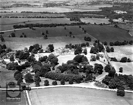
The purchase of the Woolley by Michael Wentworth in 1599 marked the start of a 350-year period during which the estate would be held by this minor branch of the family who owned Wentworth Woodhouse. The present-day Woolley Hall was built c. 1635 and the surrounding designed landscape has been evolving with the changing fashions and successive owners ever since. Prior to this period a deer park and gardens are thought to have first been laid out during the 14th century by the Woodroves.
During the 18th century, under the Wentworths, enclosed terraced gardens with geometric designs, an orchard and courts bounded the hall on three sides. Later that century, Woolley Dam, an artificial body of water forming the east boundary of the park, was greatly extended by the noted engineer of the time, James Brindley.
The landscape that is seen today was largely developed over the period 1795-1825 by Godfrey Wentworth Armytage [later Wentworth] II who consulted leading landscape designers and architects of the time. Though designers including John Webb submitted proposals, no scheme was fully implemented but individual elements were used to create a picturesque landscape fashionable for the time. Renowned architects of the day, including Sir Jeffry Wyatville, Charles Watson and James Pritchett, were consulted on architectural features including the elegant east entrance lodge.
During the 19th century, a picturesque woodland garden was developed with an ornamental stream and cascades, whilst walks extended towards a boating lake developed from Woolley Dam. Formality was reintroduced to the west garden through the construction of Italianate terraces, a sunken garden and geometrically arranged flower beds.
The park and gardens then remained largely unchanged until the hall was sold in the mid-20th century. This breaking up of the estate marked the end of four centuries of association of the Wentworth family with Woolley. Despite changes in use, including the establishment of a college and construction of a golf course, the historic designed landscape around Woolley Hall today remains largely legible and extant.
Estate owners
The Woodrove family, having purchased the capital messuage and lands in 1377, held the estate for over two centuries. Sir Richard Woodrove (c. 1446-1522) created Woolley Park and the family is credited with laying out the garden described by Christopher Saxton in his survey drafted in 1599 following the sale of the estate to Michael Wentworth.
Michael (c. 1548-1641) of Creskeld was the founder member the Wentworth lineage that settled at Woolley for 350 years. Sir George (1599-1660) succeeded his father Michael in 1641. Being a staunch royalist throughout the Civil War, the Woolley estate left by Sir George was greatly impoverished by the time of his death in 1660 (Wentworth 1893, 159-160). Dying without a surviving male heir, the estate passed from Sir George to his brother John (1607-1682). John had trained as a lawyer in Italy at the University of Padua during the 1630s and in the next decade travelled to France to attend Lord Strafford (Wentworth 1893, 160-61). On John’s death Woolley passed to his son, Sir Michael (1654-1696) and then to his son William (1675-1729) who died without issue.
Godfrey Wentworth I (1705-1789) inherited Woolley from his uncle William in 1729 and, shortly after in 1731, Hickleton Hall, which is situated 6 miles west of Doncaster, from his grandmother (widow of Sir Michael). Hickleton Hall was Godfrey’s principal residence throughout his adult life. During this time, he pursued an interest in politics, being an alderman in the city of York for 15 years, Tory member of Parliament for the constituency from 1741-1747 and then serving as the Lord Mayor of York in 1759. On his death, Godfrey I, having outlived both of his sons, left his considerable fortune to his maternal grandson Godfrey Wentworth Armytage II.
Godfrey II (1773-1834) was raised at Kirklees Hall to parents Sir George Armytage and Anna Maria Wentworth (daughter of Godfrey I). He was 15 years old in 1789 when he inherited Woolley. As stipulated in the bequest, Godfrey II took the name Wentworth in lieu of Armytage [Godfrey Wentworth Wentworth II]. After completing his education at Trinity College, Cambridge in 1791, he married Amelia Hawksworth, daughter of Walter [Hawksworth] Fawkes of Hawksworth and Farnley Halls, in 1794 and attained his majority in 1795. Following a brief and unremarkable period in Parliament, holding the constituency of Tregony 1806-1809, Godfrey II gave up his seat. Then around 1812, he became a partner in the historical Yorkshire banking house Wentworth, Chaloner and Rishworth. For a period, the bank was highly prosperous, but the financial crash of 1825-1826 led to its collapse and Godfrey II being declared bankrupt. A settlement made in favour of Godfrey’s eldest son, Godfrey III, some years early prevented creditors from seizing the Woolley estate and allowed him to purchase the property saving the family from ruin. Godfrey II was obliged to see out his remaining years at his modest home in London until he died in 1834 age 61 years.
Godfrey III was succeeded by his son, Godfrey Hawksworth Wentworth IV (1829-1899), who held Woolley for 34-years until he died without an heir. The hall passed briefly to his 75-year-old sister Ann Wentworth (1824-1901), who also died without leaving any children. The estate passed to another sibling, Catherine Mary Withington (1834-1915) who resumed the name Wentworth in 1901. In 1915, her 54-year-old-son, Guy Edward Wentworth Withington (1861-1936) inherited the estate and assumed the name Wentworth. The final member of the family to reside at Woolley was Guy’s son Michael Wentworth Ewart [who also assumed the name Wentworth]. He oversaw the sale of the property in 1947.
The estate was broken up with Wakefield Council purchasing the hall and immediate grounds (including the stables, west garden and south approach). The hall was initially developed as a college and then used as a commercial enterprise, before falling into disrepair. After standing empty for around a decade, the Council sold the property to an undisclosed buyer in September 2025. The park fared better, first being set over to agriculture and then redeveloped in 1995 as Woolley Golf Course.
Key owners responsible for the major developments of the designed landscape and dates of their involvement:
Sir Richard Woodrove (c. 1489/1509 - 1522)
Michael Wentworth (1599 - 1641)
William Wentworth (1696-1729)
Godfrey Wentworth I (1729-1789)
Godfrey Wentworth [formerly Armytage] Wentworth II (1789-1825)
Godfrey Wentworth III (1825-1865)
Early history of the site
Believed to be of Anglo-Saxon origin, the name Woolley is thought to have originated from ‘wulf’, meaning wolf, and ‘hleo-leah-leye’, referring to land that has remained untilled for some time (OED), i.e. meaning ‘the wolves’ shelter’ (Walker, 1924). The two manors of Santone (location status lost) and ‘Wiluelai’ [Woolley] are recorded in the Domesday Book (1086) as being held by ‘Turchil’ [Thorketill], a Saxon, before 1066. Historically, spelling of the name has varied with Wolley generally being predominant into the 19th century and then Woolley becoming the recognised form after the mid-19th century.
During the 14th century, William de Notton, who held notable posts within the realm, including king’s serjeant and justice of the king’s bench, owned two bovates of land in Woolley (1327) to which he added during his lifetime. On his death (c. 1365), the land, together with the capital messuage and land in the adjacent village of Notton, was bought by William de Fyncheden, steward of the household and king’s chamberlain, and then sold to John Woodrove of Normanton in 1377 (Markham 1979, 3).
In 1425 the manor of Woolley was held by Willielmus de Rilleston passing to subsequent generations of the Rilstons until c. 1489 when it was granted to Sir Richard Woodrove (c. 1446-1522), High Sheriff of York and descendant of John Woodrove. It is said that at this time, Sir Richard acquired about half the land in the manor of Woolley, including the lordship of the manor and the manor house. Then through an agreement with Sir James Strangeways, who held the manor of Notton, Sir Richard created Woolley Park (Markham 1979, 4).
Sir Richard Woodrove’s daughter, Beatrice, married Sir Thomas Wentworth (d. 1548) in 1514 linking Woolley with the family of the great estate of Wentworth Woodhouse. Francis Woodrove (d. 1618) (great-grandson of Sir Richard) acquired the adjacent Manor of Notton in 1556 expanding the estate further (Markham 1979, 4). In 1599, his son, another Francis Woodrove, sold Woolley together with the estates of Notton and Cold Hiendley, for £6000 (equivalent to £830,000 in 2017) to his kinsman Michael Wentworth (c. 1570-1641) (great-grandson of Sir Thomas Wentworth and Beatrice [Woodrove], marking the end of the Woodrove’s and start the Wentworth’s lordship of Woolley.
Chronological history of the designed landscape
1599-1696
Following the purchase of the Woolley estate in 1599, Michael Wentworth (c. 1548-1641) instructed the leading cartographer of his day, Christopher Saxton, to complete surveys of the three manors he had obtained: Woolley, Notton and Cold Hiendley. Saxton’s written survey of 1599 documents the Woolley estate within which the demesne totalled 397a 2r 7d 1p [d, dayworke is a measure often used by Saxton in surveys] (approx. 161 hectares or 1.6 km2) (LUSC /25). Almost two thirds of this land is described as pasture (approx. 254 acres), with the rest being listed as ‘spring’ [referring to a copse of young trees] (approx. 50 acres), wood (approx. 29 acres), meadow (approx. 23 acres), ‘royd’ [land cleared of trees to be cultivated for either pastural or arable use] (approx. 21 acres) or arable (approx. 7 acres). By comparison, the area of the park and garden under consideration in this report is approx. 240 acres (approx. 97 hectares or 0.97km2), 60% of the demesne land recorded in 1599 (Figure 1).
In the absence of a 16th century plan of the estate, it has not been possible to map named areas to precise locations, the exception being the original hall and a coney warren. The original manor house built by the Woodroves was identified by Coxon (Clerk of Works for the estate from 1892 to after 1925) as having been located adjacent to but southwest of the extant hall (LUSC /M45). He also stated that an ancient coney warren was in an area called ‘Horse Park’, which was directly south of the hall as identified on the 1749 survey (Figures 2 - 4). The presence of a ‘coney clapper’ [a warren specific to housing breeding does and their offspring] on the 1749 plan due east of ‘Horse Park’ supports this assertion. Also, the area of ‘Horse Park’ (19a 3r 5p in 1749) corresponds with Saxton’s ‘The Conye Parke pasture’ (18a 3r 7d 2p in 1599). Godfrey IV recorded the warren as being within ‘The Rakes’, an area adjacent and east of ‘Horse Park’ (Wentworth 1893, 16). Together the data suggests that this substantial structure extended some distance along the south side of the park.
Early estate improvements during the 1610s saw the coney warren relocated from the park to Staincross wastes some distance from the main estate, whilst a legal Grant of Free Warren was awarded by the Crown in 1616 (LUSC /18/1). By the 1630s, Michael was openly discussing building a new residence. His friend and relative Sir Thomas Wentworth (1593-1641), Earl of Strafford of Wentworth Woodhouse, wrote to him in 1634 warning of the perils of house building:
If you builde a new house, remember that I tell you, itt is a matter whearin you may showe a great deale and a great wante of discretion, itt being nothing so easye a thing to builde well as men take itt to be, that knowe it not, and therefore att your perill, looke well aboute you (Wentworth 1893, 6).
Clearly taking no heed of this warning, Michael wrote to his kinsman of his new home ‘From our newe house at Wolley where I would be please to see you before I dye’ (Wentworth 1893, 5). It is likely that Sir George Wentworth (1599-1660) assisted his elderly father, Michael, who by this time was in his late 80s, in the construction of this highly fashionable house with Flemish gables, possibly unique in Yorkshire at this time. Michael died only a few years after completing the hall, which then passed through two subsequent generations of the family before coming into the possession of his great-grandson, William (1675–1729).
1696 - 1729
The earliest identified depiction of the hall’s garden was drafted by Samuel Buck in 1720 when William was the owner (Wakefield Historical Publications 1979, 134-5). The hall at this time retained the basic H-plan of c. 1635 with an extension built onto the east side and the assumed chapel on the southwest corner. To gain access to the hall during this period, visitors passed through an ornate gateway decorated with a Flemish gable, reminiscent of the stonework of the hall, and into an enclosed court on the south side of the building. Outbuildings backed onto the right of this court, whilst compartmentalised gardens were laid out beyond the wall to the left. Though details are sketchy in the drawing, two, possibly three, walled gardens are aligned north-south and linked by gateways decorated with ball-finials. A two or three-storey summerhouse with a hip roof surmounted with a ball finial occupies the northwest corner of the second enclosed area and clipped plants are seen beyond.
In addition to the topiarised shrubs shown by Buck, auriculas are known to have been grown at this time. In correspondence between Thomas Petre (d. 1729) (a roman catholic priest to the Waterton family at Walton Hall) and Dr Richardson of Bierley Hall (a leading botanist in the north of England) there is discussion of the ongoing exchange of plants and seeds, and specifically Auricula plants, between the two men and the gardener of Woolley Hall (Nicols 2015, 332-3, 336). Petre wrote:
I have some bold Auricula’s raised from Mr Wentworth’s of Woolley’s seed, which you may most freely command; but I beg, dear Sir, that you would not give yourself the trouble, unless you think them worth fetching (August 10th, year unknown).
I have lost most of my best Auriculas and July-flowers. The Woolley gardener lately bought me some Auricula blossoms, some whereof were, he said an exchange from your garden, and if any such, or a few layers, can (with your convenience) be spared, they will be mighty welcome (April 10th, year unknown).
Since Petre is thought to have died in 1729, these exchanges must have been prior to this time.
William was active at this time developing the park. Accounts in the archive identify substantial financial costs that relate to walling within the park. A bill covering a period from 1709-21, records John Thickett being paid £155 6s 7d for work relating to the collection of stone and walling, with £34 10s 0d specifically paid for ‘Park Wall’ (LUSC /15). Whilst a separate undated bill documents payment of £4 19s 6d to Ro: Wade for work on the park walls and £9 4s 0d to John Thickett for 184 days work also on the park walls (LUSC /15). In 1715, ‘the crose wall’ 78r (approx. 400m) at a cost of £19 10s 0d and ‘the partition wall between Litle Field and Milne Carr’ 60r (approx. 300m) at a total cost of £15 0s 0d are recorded (LUSC /15). Furthermore, it was said during a lecture delivered by Mr Wells, head gardener at Woolley during the early 20th century, that Willam had planted many trees during 1720, in particular copper beeches (Wakefield and West Riding Herald, August 1907). Finally, a gardener’s bill for the period May 1728 to July 1729 identifies the purchase of 11,500 3-penny nails and 700 4-penny nails, as well as a pair of garden shears (LUSC /15).
Intriguingly, accounts from 1724-1726 also mention a ‘bathingroom’ [bathhouse?] and of a ‘Park House containing a staircase and Yew Parlour’ [summer house?] (Markham 1979, 24). Nothing more is known of these structures. William died in 1729, without issue, leaving the estate to his 24-year-old nephew Godfrey Wentworth I (1705-1789).
1729-1789
Within the two-year period 1729-1731, Godfrey I inherited the Woolley estate from his uncle William and Hickleton Hall, near Doncaster, from his grandmother. Of the two, he chose Hickleton as his principal residence, rebuilding the hall there 1745-48, whilst the Woolley estate formed a major source of his income. A survey of the Woolley estate completed by Scot in 1749, possibly instigated by the drafting of a deed of separation between Godfrey I and his wife Dorothy in the same year, listed the demesne lands to cover an area of 195a 1r 7p (half the acreage listed in 1599, and 80% of the site considered in this report) (LUSC /M49) (Figures 2-4).
The terraces, compartments and summerhouse detailed on the 1749 plan correspond with those depicted by Buck in his 1720 sketch suggesting the basic structure had remained largely intact during those three decades. In 1765, Godfrey I appointed James Brindley, the esteemed engineer and canal builder of the time, to extend Woolley Dam, which is situated on the far east side of the estate, to cover an area approximately three times greater than the original body of water. Since there is no obvious financial gain to extending the dam, it might be assumed that the project was undertaken to enhance the aesthetics of the estate.
Although absent from Woolley, Godfrey I made provision for the gardens to be maintained by the gardener George Brown of Woolley (LUSC /44). In an agreement drafted at Hickleton and dated 12th October 1771, Brown agrees to:
…occupy for his own us and benefit all those gardens at Woolley aforesaid called the Hall Gardens which the said George Brown doth agree to keep in perfect order viz [namely] the gravel walks, the bowling green, the clipt hedges and the evergreens, and the wall trees pruned and nailed and shall renew the same with young plants when they require it and shall leave the same in such order and condition as aforesaid when ever he may happen to quit the occupation of the said gardens either by his own choice or that of the aforesaid Godfrey Wentworth he is also to keep the court before the hall door mown and rolled when it may require it…(LUSC /44).
An allowance of 10 loads of manure was provided to Brown gratis every year for the upkeep of the gardens, after which he was required to pay 4 shillings a load (LUSC /44). Archive material of accounts from 1778 also refers to the creation of a fishpond (£12 12s 0d), the location remains unknown (LUSC /15).
In addition to maintaining and enhancing the estate, Godfrey I took every opportunity to increase its acreage, acquiring sizable tracks of land around Woolley village. In 1733 he acquired the Ellis’ estate and in 1783 he purchased for £7,500 the substantial estate held by the Prince family, which included Mount Farm, located in the centre of the village (Walker 1924, 278, 281). By this time (1783), he held the entire township with the exception of a small area retained by the neighbouring Bretton estate. Godfrey I died in 1789 aged 84 years leaving Woolley and his sizable fortune to his 15-year-old grandson Godfrey Wentworth Armytage II (1773-1834).
1789-1825
During the period between 1749 and 1809, substantial changes were made to both the garden and park. The formal geometric garden situated on the western side of the hall and the courts to the south were completely removed and the park extended around the southern and western facades in the fashionable style of the picturesque. Whilst the area of the park had been extended on the northern boundary. Home Farm and a walled kitchen garden were also constructed during this time. Whether it was Godfrey I or his grandson Godfrey II that was responsible for these alterations is unclear, but certainly Godfrey II made substantial changes to both the hall, park and gardens during the 30-year period that he resided at the estate.
Following their marriage in 1794, Godfrey II and Amelia moved to Woolley Hall (LUSC /M45) (Figure 5). Within the year, he attained his majority and immediately commenced a major programme of alterations to the hall and grounds that would extend over three decades. An insurance policy dated 1806 refers to the range of outbuildings east of the hall, indicating that they were still present at that time. They would, however, soon be replaced with two new stable blocks. The north stable block was the first to be constructed (present by 1809) with the smaller second block being finished c. 1810 (Figure 6). Plantations were grown on the north, east, and south sides of the stables to obscure these new buildings from the park.
Godfrey II commissioned John Webb (1754-1828) an architect and landscape designer renowned for his picturesque landscapes to draft plans for the garden and pleasure ground. Born near Derby, Webb initially trained under William Emes who had been the head gardener at Kedleston Hall in Derbyshire, before setting up his own business in 1793. He worked principally in the Midlands and Cheshire, though he is credited with designing Thrybergh Hall near Rotherham (1813-14), which is only 20 miles from Woolley (O’Halloran and Woudstra 2009,19-43).
Webb’s proposal, dated 1811 and anticipating the rerouting of the two public highways (completed c. 1818), outlines an extended park cast in the picturesque aesthetic (LUSC /M65). The layout is informal with open areas of grass and groves of trees, with an irregular body of water (Figure 7). In the plan, an access route links with the turnpike road at the northern end of the dam, bringing visitors through the park to the hall from the northeast. A second carriageway enters the park from the southeast at the junction between New Road and the altered turnpike road. A third and final approach from the south provides access to both Home Farm and the hall. A drying area surrounded by plantation is positioned southeast of the new north stable block. The southern tip of Woolley dam extends into the park, dividing into two heads of water. The north bank of the irregularised water is surrounded by plantation, whilst the southern bank is open with only isolated trees. The park itself is also open with groves, clumps and specimen trees, the two ancient tree-lined avenues having been removed.
An unsigned, undated second survey shows the new north stable block (built by 1809) but not the south stable (thought to have been built in 1810) (LUSC /M69) (Markham, 1979, 45). However, the illustration of the bay window on the west side of the hall (alteration c. 1796-1807) and the portico of the south façade (remodelled c. 1810), which are absent from the Webb design, suggests a date around 1810 and before the rerouting of the Woolley-Notton road around 1818. Compared to Webb’s proposal, this one is confined to the areas south and east of the hall. Less ambitious than Webb’s, the design shows thick belts of trees on the southern and western boundaries of the park providing privacy. The park is open with few trees, generally in small clumps and isolated specimens with a fence or ha-ha appearing to separate the boundary plantations from the park. The two tree-lined avenues within the park are retained by the designer, but an artificial lake has been included in the plan at the southern tip of the avenue running north-south.
Whilst neither proposal was fully implemented, components appear to have been taken from them. Works undertaken at some point included the construction of a lengthy ha-ha running along the northside of the garden, across the back of the hall and wrapping around the stable blocks. This allowed the park to be admired without ugly fences spoiling the view, whilst livestock, possibly deer, were kept away from the hall and garden. The fishponds by the original outbuildings were backfilled and fields on the northern boundary were brought into the park. The two tree-lined avenues were preserved, and some isolated specimens, remnants of those earlier field boundaries, were retained. In addition, two small circular groves were developed.
Two public highways, one running along the southern boundary and the other through the park to the east, were diverted removing awkward bends and allowing expansion of the park in both directions (Figure 4). The Woolley to Notton road running east-west was straightened and moved further south bringing a plantation into the park and providing the family with greater privacy from the public highway – the aptly named ‘New Road’. The precise date of this construction work is unknown but must have been around the same time as the turnpike was rerouted, c. 1818. Watson and Pritchett submitted designs for an ornate lodge and carriage gates dated 1814 for this approach, though there is no evidence to suggest that these designs were executed (LUSC /M26). The rerouting of the Wakefield to Sheffield turnpike, undertaken at considerable cost to Godfrey II, with a financial contribution of £700 from the Turnpike Trustees (WYAS JG001530), had the effect of shortening and straightening two sections of the road whilst pushing the thoroughfare further east, thus increasing the area of the park adjacent to the hall (LUSC /25). This alteration to the highway necessitated the entrance lodge to be moved and the approach to be extended. A new ornate Sheffield Road lodge was designed by Jeffry Wyatt, later Sir Jeffry Wyatville, the esteemed architect of his day who would go on to redesign Windsor Castle for King George IV (Figure 8). Set into the curving curtain walls, tall gate piers were built supporting the Wentworth Gryphon with ornamental cast iron gates for both carriages and pedestrians; this lodge was designed to announce to visitors that they had arrived somewhere significant.
The official opening in 1818 of the new turnpike was combined with the celebrations for Godfrey III coming of age and is recorded in the book of lithographs commissioned by his father from Agostino Aglio and published (1821) (section 4.7.1). In one image a splendid horse and carriage procession is shown bringing guests along the new road and into the park for the festivities (Figure 9) whilst another illustrates the temporary ballroom erected for the occasion (WYAS WYW 1884/5).
One of the major periods of transformation of the gardens and park was during the three decades when Godfrey II was seated at Woolley. The opportunity for further embellishment however, ended with the financial crash that resulted in the collapse of the banking house Wentworth, Chaloner and Rishworth. Godfrey II was forced to sell Hickleton and a large portion of the Woolley estate, whilst Woolley Hall was sold privately to his eldest son, Godfrey III (Clarkson 1985, 163-165). Godfrey II passed his remaining years at his residence in London.
1825-1947
Descendants of the Wentworth family continued to live at Woolley Hall for the next 120 years. It is likely that following the demise of the family fortune in the 1820s, Godfrey III (1797-1865) did not have financial revenue to undertake substantial groundworks comparable to those of his father. This is also reflected in the decrease in employed gardeners from five to three at this time. During the decade 1839-1849, the stream running along part of the south boundary of the park and into the dam at the southern tip was developed into a picturesque woodland stream with pools and cascades. Given the geographical proximity and contemporary construction date of the earliest known boathouse (built c. 1837-1851), it is conceivable that walks through this mixed planting, wooded area connected with the dam and the boathouse via the bridge traversing the turnpike road at this point.
With the arrival of industrial scale coal mining in the area during the 1850s-1860s and coal being extracted from under the estate, the family revenues improved. It is during the 1860s that formal terraces, which remain in existence today, were constructed in the garden west of the hall. During a lecture delivered in 1907 by Mr Wells, the head gardener of the time, he referred to the laying out of the terraces and gardens 40 years previously by unemployed miners (Wakefield and West Riding Herald, 31 August 1907). After the announcement in 1861 of a 20% cut in pay, miners at Woolley Colliery went on strike. The colliery refused to re-employ striking miners, bringing in new men from outside of the region. It is likely that Godfrey III used these unemployed local men as a source of cheap labour, whilst giving them a source of income, to construct the garden under the instruction of his head gardener, Mr Usher, and his small team of two other gardeners.
Substantial levels of tree planting were taking place during the 1860s. An order placed with Mr James Smith of Darley Dale Nurseries in Matlock, Derbyshire, during February 1865, requested 1000 Italian poplar of 3 feet, 3000 larch of 3 feet, 1000 spruce fir of 3 feet, and 1400 scotch fir of 3 feet (LUSC /118). Unfortunately, as the ‘scotch fors’ [sic] were considered too small, additional spruce and Italian poplar were supplied forming a final order of 2000 spruce ‘as large as could be found’, 1400 Italian poplar and 3000 larch. A request was made that these 6400 trees, which were to be used to repopulate the plantation, be trenched into the ground until planting could be completed. The following December (1865), 1000 scotch firs not less than 3 feet high (presumably those that were deemed too small during the previous winter) and 500 Spanish chestnuts the same height were purchased from Smith. Unfortunately, when the Spanish chestnut arrived a month later, they were deemed too large and declined. It is notable that these were destined to repopulate an earlier plantation site, but the exact location remains unknown.
On the death of Godfrey III in 1865, Woolley passed to his eldest son, Godfrey IV (1829-1899). Alterations within the gardens appear to have been few and relatively minor at this time, but the quality of the flower gardens and plants within the glasshouses were upheld. During a visit to the garden and conservatories by the West Riding Naturalist’s Society in 1874, splendid specimens of Ficus cariea [fig tree], Ficus elastica [rubber plant] and a fruiting Muso paradisiaca [bread fruit tree] were observed (Wakefield Free Press, 1 August 1874). In 1883, the Paxton Society were conducted through the ‘extensive ranges of glasshouses and conservatories’ by the head gardener, Mr Hudson:
Noticeable were a large houseful of calceolarias, beautiful alike in colour, in marking, and in health, a splendid plant of Stephanotis floribunda [Madagascar jasmine], trained along the roof, gloxinias, ferns, orchids, together with a host of other fine foliaged and flowering plants… (Wakefield Free Press, 30 June 1883).
Among the fruit noted to be growing were abundant crops of grapes, peaches, and nectarines. Whilst in the terraced garden conifers, rhododendrons and azaleas were observed (Wakefield Free Press, 30 June 1883). Returning to the park in 1897, members of the Paxton Society admired veteran chestnut trees within the park, one of which ‘was barely spanned by the extended arms of four of the visitors’ (Wakefield Express, 14 August 1897).
On his death in 1899, Godfrey IV remained single and without an heir. Woolley passed briefly to his aged sister Anne (1824-1901), then to another sibling Catherine Mary (1834-1915). During this period the former head gardener Mr Hudson left the estate and was replaced by Mr Thomas Wells, presumably being employed by Catherine when she inherited the hall. It was under his leadership that the number of gardeners tending the gardens increased with seven being recorded. Mr Wells recalled during a lecture a number of years later how he had converted ‘the place from a howling wilderness, to a veritable floral paradise, which now attracts large numbers of botanical experts and gardening enthusiasts from all parts of the country’ (Wakefield and West Riding Herald, 31 August 1907).
In 1905, visitors were fortunate to view the many deer within the park (Wakefield and West Riding Herald, 29 July 1905). Two years later the Paxton Society returned for a further visit, this time marvelling the:
…double begonias and cortons, gloriosums, cyclamens, etc., were all superb. The crimson ramblers proved a fine show, Dorothy Perkins particularly so…. violas, pansies, calceolaria, marguerettes etc., a touch of the orientalism being given to the front of the hall by a number of flower tubs, while even the festoons worked around the borders on the front lawn were exceedingly pretty and effective (Wakefield and West Riding Herald, 24 August 1907).
The party left complementing Mr Wells on the grounds and gardens, which ‘cannot be equalled for many miles around’ (Wakefield and West Riding Herald, 24 August 1907). Whilst clearly an accomplished gardener, Wells was also regarded as an expert and renowned carnation grower, including the Malmaison carnation, giving lectures on this florists’ flower (Wakefield and West Riding Herald, 22 August 1908; 8 July 1911). Although Catherine, was a subscriber to the Wakefield Amateur Tulip Society, 1907-1908 (now known as the Wakefield and North of England Tulip Society, WNETS), and it had recently been agreed by their committee to permit professional gardeners to exhibit, there is no known evidence to suggest that blooms from the Woolley estate were prize winners (Wakefield and West Riding Herald, 31 August 1907; WNETS).
During the 1910s, Woolley was famed for a bower supporting the rose Dorothy Perkin, possibly describing the festoons along the west garden lawns. This award-winning old-fashioned pink, semi-double rambler was a relatively new rose, having been introduced by Jackson and Perkins in 1901. The gardens were also celebrated for their extensive ferneries and peach houses (Wakefield and West Riding Herald 24 August 1912). Nothing is known of the ferneries, but a book of flora around Wakefield published 1867, recorded Cystopteris fragilis [Brittle Bladder Fern] to be growing at Woolley. Its presence was explained as the specimen having been taken from a rockery [fernery?] in the garden (Gissing 1867, 49). The location of a rockery or fernery is unknown but is possible that this was located within the woodland walk area developed c. 1839-1849.
On Catherine’s death in 1915, the estate was inherited by her son, Guy Edward Wentworth [Withington] Wentworth (1861-1936), and finally to his son Michael Wentworth Ewart [Withington] Wentworth. During WWI, in addition to the head gardener and foreman there were four men and two boys caring for the grounds. In later years, one of those boys, George Coatesworth (b. 1903) would recall working in the four vineries and four peach houses and cultivating the many other fruit types including melons (Markham 1979, 55-57). Little is known of the gardens during this early part of the 20th century, though the park was ploughed and turned over to agricultural use during the war (Bradford Observer, 23 July 1947).
Woolley Dam was leased to the enterprising Arthur and Ernest Sergeant brothers in the 1920s, who in turn hired out boats, provided swimming facilities and supplied soft drinks, sweets and cigarettes as well as donkey rides to the paying public (Elliott 1998, 163). With the focus of the business being at Mill Farm on the east bank, the area became a popular recreational site visited by locals as well as people from as far as Wakefield and Barnsley (Figure 10).
1947-present time
During the late 1940s the Woolley Estate was broken up and sold by the last of the Wentworth family to reside at the hall. Ownership of Woolley Hall passed from Michael to West Riding County Council in 1947. Five years later, and under the leadership of the pioneering educationalist Sir Alec Clegg, Chief Education Officer for the Country, Woolley College opened as a residential in-service training centre for teachers. Advocating a role for the arts in education, Clegg was also a founder of the teacher training collage sited at the adjacent Bretton Hall which opened during the same period. On the retirement of Clegg in 1974, there was a desire to commission a commemorative sculpture by a renowned local artist and Henry Moore was approached (HMF/ Sarginson). Following an ‘hospitable visit’ by Moore to Woolley Hall College during February 1974, an offer of the loan of ‘Upright Motive No.2’ was made (HMF/ Marriott). That summer the sculpture was placed on display on the lawn southwest of the hall and remained there until it was returned to Moore in November 1978 (Figure 11) (WYAS WYW 1673; HMF/Hoglands). At around the same time a bronze by the artist James Tower was on display within the grounds. The terraced rose gardens are recorded at the time of the sale of the hall in the 1940s (Bradford Observer, 23 July 1947), but the image of Upright Motive No.2 within this area of the grounds suggests a simplification of the garden to have taken place in the preceding decades. After the college closed in the c. 2000s, the hall became a wedding and conference venue but in recent years it has stood empty. In September 2025 Wakefield Council sold the property to an undisclosed buyer.
Woolley Dam, which constituted a 16-acre crescent shaped lake at the time the estate was dissolved, was sold to the National Coal Board (NCB). The lease of this recreational facility continued until the decision was taken in 1951 to drain the lake on health and safety grounds due to the possibility of the dam failing and threatening nearby Newmillerdam (Bradford Observer, 17 August 1951).
With the decline in farming during the 1990s, the agricultural land within the old deer park was redeveloped into a golf course. Woolley Golf Club opened in 1995. Despite the major change in land use, features of the old park have persisted. The positions of historic tree avenues can be observed as ‘ghosts’ in the current planting (Figure 12) and substantial sections of the ha-ha remain intact (Figure 13). The derelict east entrance lodge remains and a significant section of the carriageway from the east entrance now serves as an access track. The icehouse remains extant and remnants the stream and cascades persist, though these are relatively inaccessible. Interestingly, a pond now occupies the site of one of the ancient fishponds.
Location
Woolley Hall is located next to the village of Woolley, 7 miles south of Wakefield and 6 mile north of Barnsley.
Area
In 1599, the demesne totalled 397a 2r 7d 1p (approx. 161 hectares or 1.6 km2) and by 1749 the area was reduced to 195a 1r 7p (approx. 79 hectares or 791,300 m2). The historic area of the 19th century hall, gardens and parkland is 240 acres (approx. 97 hectares or 971,200m2) (Figure 1).
Boundaries
The northern boundary runs from the northeastern side of Woolley village at SE 321 132 to the kennels at SE 328 137, south to SE 330 135 then due east to the A61 Barnsley Road, north along the A61 to Mill Lane, then along Mill Lane to Mill Farm and then returning to the A61 via the outer edge of Woolley Dam. Crossing the A61, the boundary continues along the southern bank of the stream to SE 330 129, south to New Road, along New Road travelling west past Home Farm to SE323 128, then to SE 323 130, then west to New Road, then north along New Road, then right into Woolley Park Road to SE 322 131 and around the perimeter of the vicarage returning to SE 321 132.
Landform
Woolley Hall lies at 93 m AOD. The west boundary (walled garden) has the highest elevation at 110 m AOD gradually sloping across the site eastwards to the lowest point at 45 m AOD (Woolley Dam and the Burrs) (max. slope of 30%, with an average slope of 5%). North – south there is little change in elevation through the centre of the site with a maximum height of 93 m AOD (the kennels) and a min height of 71 m AOD (Lodge Plantation) recorded.
Woolley Hall lies on Woolley Edge Rock – sandstone. These sedimentary rocks are fluvial in origin. Detrital, ranging from course to fine grained deposits. The east of the estate (east of the park including the Burrs) have superficial glaciofluvial deposits – sand and gravel. The soil across the estate is freely draining slightly acidic loamy with a loamy texture and of low fertility.
Setting
Woolley is set within the wider area of the Nottinghamshire, Derbyshire and Yorkshire Coalfield. The landscape is underpinned by generally low and undramatic, but variable hills, escarpments and broad valleys. Numerous rivers arising in the Pennines flow through the area, generally west to east, but often diverted by the escarpments into more north/south courses.
Entrances and approaches
South Approach
The two earliest known records depicting Woolley Hall date from the first half of the 18th century and both show two enclosed areas to the south of the hall. The outer court, probably a courtyard for carriages, is accessed through a gateway from a road running east-west (Figure 14) (LUSC /M49). Having passed through this gateway, visitors alighted from their carriage and proceeded through an ornate second gateway, which architecturally mirrored the stepped gable ends of the hall, before entering an enclosed garden (Wakefield Historical Publications 1979, 134-135). Between 1771, when George Brown was contracted to keep the court before the hall ‘mown and rolled’, and 1809 this garden and courtyard were removed (LUSC /44, LUSC /M39).
By 1809, the courtyard had gone and there was a new access route from the south (LUSC /M39) (Figure 15). The new south approach brought visitors from the Woolley to Notton road, through a plantation, and along a 300m carriageway sweeping anticlockwise to arrive at the main entrance on the south side of the hall (Figure 16).
During the 1810s, the rerouting of the public highway running east- west across the southern boundary of the hall created ‘New Road’. This does not appear to have altered the position of the south approach entrance. Today, this entrance forms the only access route to the hall.
New Road (South) Lodge [Grade II NHLE: 1135528] SE 327 128
The 1809 estate map shows a pair of crudely marked lodge buildings on either side of the entrance prior to the rerouting of the public highway (the proposed route being shown as a dashed line) giving the appearance of these having been added at a later date (LUSC /M39). An undated plan of c. 1809, on which changes to the road are also drafted, shows no lodge (WYAS JG001530). The implication being that there was no gatehouse at the south entrance prior to 1809 and that the first lodge was constructed around the time the road was rerouted during the 1810s.
Watson and Pritchett submitted a design entitled ‘Elevation of a design for a lodge and gateway at Woolley Park’ dated 1814. This proposal includes cast-iron pedestrian and carriage gates with piers topped with ornate urns and double storey lodge positioned to the right of the gates (LUSC /M26). Holt’s estate plan of 1829 and later OS maps reveal structures flanking the carriageway. The one on the east side of the entrance is the larger of the two and shown with a markedly greater footprint than appears on later OS maps (LUSC /M13; OS 25” revised 1904).
It is unclear whether the Watson and Pritchett’s design was realized, but clearly a lodge has existed on this site for two centuries and has probably undergone a number of alterations during this time. The extant pair of small hexagonal single storey buildings with pyramidal roofs and cast-iron gates are extensively overgrown with ivy and encroaching shrubs (Figure 17).
East Approach
The original east entrance was installed between 1749 and 1809 linking the hall with the old Sheffield to Wakefield turnpike road (Figure 15). The turnpike ran through the estate separating the park from the Burrs and Woolley Dam. The work to reroute the highway was completed by 1818 and had the effect of shortening and straightening two sections of the road whilst pushing the thoroughfare approx. 130 m east, thus extending the length of the approach to the hall and increasing the area of the park adjacent to the hall (LUSC /25) (Figure 4). Once named Sheffield Road, today it is known as the A61 Barnsley Road.
Arriving at the new Sheffield Road entrance, visitors were brought along a curving carriageway of approx. 920 m (Figure 8). At a point midway along the approach, carriages passed through a plantation, which then opened out to reveal the south facade of the hall (Figure 15) (LUSC /M39).
Sheffield Road Entrance (East) Lodge [Grade II NHLE: 1200715] SE 335 133
The first east lodge was installed between 1749 and 1809. A mason’s bill dated August 1794 outlines costs related to ‘the Porter’s Lodge’ (WYAS WYW 1884/5). The location is not stated, but it is likely that it refers to the original east lodge (Figure 15).
With the rerouting of the turnpike (1818), the earlier building became redundant, and a new entrance was required. Jeffry Wyatt submitted three sets of plans dated 1820 for a ‘Sheffield Road’ entrance lodge with ornamented cast-iron gates which permitted access to the park from the turnpike (Figure 8) (LUSC /M27, /M29, /M67). Built to the design, ornamental arched pedestrian and carriage cast-iron gates were set into the curve of an outer wall. Concealed behind the southern section of the wall was a four roomed lodge. Wyatt was paid £136 10s 0d in 1823 for his services, and Machell [?] was paid £178 10s 0d for the iron gates (Linstrum 1971, 14). The lodge and gates are extant though in a ruinous state.
Bridges on the turnpike road
Bridges must have carried the old road over the Seckar Dike at the north end of the dam and at the point at which a second feeder stream runs from the park into the dam at the southern extremity. Rerouting of the turnpike replaced the section of road between the two bridge sites and ornate stone structures were newly constructed to carry the road over the dikes c. 1817 (WYAS JG001530).
Located 87 m south of the east lodge, the bridge had an ornamental balustrade forming a parapet, which is clearly visible in Aglio’s lithograph (Figure 9) (WYAS WYW 1884/5). By the first decade of the 20th century the fabric of this bridge was in a poor state of repair with a number of the turned balusters being badly decayed and others having fallen into the stream below. Correspondence between West Riding Highways Committee and Catherine Wentworth concerning liability for necessary repairs led to an agreement eventually being reached in 1909 between the two parties in which Catherine agreed to take responsibility of the ornamentation (WYAS JG001530).
Today, evidence of the bridge seen from the road is limited to a change in the appearance of estate wall; a section of dressed stone blocks and coping stones on the park side of the road. From the highway, the presence of the bridge over Seckar Dike is less obvious, marked only by simple dressed coping stones which cap the wall enclosing the estate. The east side of this bridge, when viewed at distance from Mill Lane (on the dam side of the A61), has evidence of some of the original ornamentation with vermiculated rustication of the stone arch within the bridge structure (Figure 18).
Principal buildings
Woolley Hall
Woolley Hall [Grade II* NHLE: 1135534] SE 327 130 is constructed of hammer-dressed stone, ashlar dressings with a stone slate roof (Historic England) (Figure 19). The Flemish gables on the extant hall are thought to be part of the original 17th century design. At the time of construction, they would have been usual for Yorkshire, indeed, Markham believed that they would have been considered a modern addition to any mansion in England during this period (Markham 1979, 7).
The original H-plan house of c. 1635 forms the nucleus of the current Woolley Hall. In the late 17th century, an extension was added to the east side and some infill of the wings of the ‘H’ on the north side undertaken followed by a further extension on the west side during the second half of the 18th century (Markham 1979, 21).
The greatest period of alteration was during 1795-1807 when additions were made on all sides of the hall and it is this structure that persists in overall size and character today. The architectural historian Derek Linstrum attributed some internal decoration c. 1796 to John Carr (Linstrum 1978, 83). It is entirely feasible that Godfrey II was introduced to Carr by his father-in-law Walter Fawkes who had previously employed the architect at both Hawksworth and Farnley Halls (Warleigh-Lack 2013, 294). The architect, Bernard Hartley of Pontefract, drew up plans and oversaw the modernisation of the hall c. 1799-1800. Unfortunately, the work was short lived with a significant fire in 1806 destroying much of the newly completed work, including a hallway, an organ and staircase. Reconstruction work was promptly undertaken, including in the dining room and vestibule, by the Wakefield architect Charles Watson in 1807-8. Alterations continued apace with George Woodhouse preparing drawings in 1814 for the remodelling of the south and west aspects of the hall (Linstrum 1978; Markham 1979, 28-46).
At the same time, the Italian painter and lithographer Agostino Aglio was commissioned to undertake internal decoration of the hall. Aglio, born in Cremona in 1777, had arrived in England in 1803. Prior to working at Woolley, he had undertaken commissions for frescoes at Woburn Academy (1808) and painting the lakes of Killarney (1810) (Newton 2004). Initially, Aglio created frescoes of classical Italian landscapes reminiscent of Claude Lorraine’s arcadian scenes on the walls of the drawing room. The designs are documented in his book of lithographs published in 1821. In 1821, Jeffry Wyatt prepared a proposal for attaching a conservatory to the west front of the mansion overlooking the formal gardens. The design incorporated half octagonal bays at either end with seating, underfloor heating and was sufficiently wide for a central flower bed or staging for the presentation of pot plants along the length (LUSC /M66). This was never built.
Pre-19th century outbuildings
Buck’s 1720 sketch suggests the presence of outbuildings to the east of the courtyard and enclosed garden on the south side of the hall. These are more clearly seen in the 1749 survey by Scot as a number of buildings loosely collected around three courtyards located east of the house. Whilst no description of these buildings or their function is provided in Scot’s survey book (LUSC /25), an insurance policy of 1806 lists the outbuildings as:
‘barn in the farm yard near the house with clock fixed in the doam [sic] standing thereon… dove coat [sic] with range of sheds and offices adjoining near… wheelwrights’ shop, coach house, stables adjoining in the stable yard… grooms stables, small barn with granary over… brewhouse… coachhouse, cowhouse… and offices communicating near with corn chambers over…’ (Markham 1979, 41).
These buildings were removed to make way for the two new stable blocks, which were constructed c. 1809-10, and were replaced by Home Farm (also known as Woolley Park Farm) built to the southwest of the hall where it remains today converted into private residences.
Home Farm (also known as Woolley Park Farm)
Home Farm (SE 325 130) was already in existence by 1809 at the site previously referred to as paddock (1749) and located west of the 18th century orchard (Figure 6) (LUSC /M39; /M49). Around this time, two ponds were dug southwest of the farm and adjacent to where the coney clapper was situated in the mid-18th century. It is of note that these bodies of water lie above the 16th century water conduit (section 4.11.1). Both ponds are extant.
Dovecote
An insurance policy drafted following the fire in 1806 refers to a ‘dove coat’ [sic] within the range of original outbuildings to the east of the hall. With the removal of the old outbuildings and construction of Home Farm, this was replaced with a new dovecote, an extant two-storey building constructed of hammer-dressed stone with a pyramidal roof [Grade II NHLE: 1200783] SE 325 130. Now privately owned.
Stables
The two extant stable blocks northeast of the hall replaced the original outbuildings that preceded them (Figure 6). The large U-shaped north stable block [Grade II NHLE: 1183580] SE 327 131 was completed c. 1809. A mason bill dated 1810 includes various costs related to the construction of the stables suggesting that the south stable block was completed the year after the north block [Grade II NHLE: 1135535] SE 327 131 (WYAS WYW 1884/5).
The U-shaped north stable block is a symmetrical two storey Georgian building with a central colonnaded cupola carrying a clock and weathervane (Markham 1979, 45). The architect’s name is absent from the undated plans for the stable block (LUSC /M32), but Markham speculated that these might have been the work of either Watson and Pritchett or Woodhouse (Markham 1979, 46). The linear, symmetrical two storey south stable has a mounting block attached to the front with an arched dog kennel underneath (Historic England). These buildings were converted into accommodation for the residential college in the second half of the 20th century but currently are unused.
Icehouse
The icehouse [Grade II NHLE: 1313219] SE 334 133 was built near to the east entrance of the park, suitably positioned to receive ice cut from the frozen dam. With the rerouting of the turnpike, the ice store is now 120 m from the new entrance and occupies a more central position within the park (Figure 6). The fact that the icehouse is shown on Taylor’s 1809 plan but absent from Scot’s 1749 estate map suggests that it was constructed in the second half of the 18th century or very early 19th century. This is earlier than the construction date of 1820 on a stone plaque placed by the ice store in 2007 to commemorate renovation work.
This functional rather than decorative small, brick, domed circular building is oval in section with a flat bottom. It is partially sunk and entered through an arched brick opening on the north side of the structure with flanking walls (Historic England). A wrought-iron fence surrounds the vegetation covered domed structure (Figure 20).
Boathouses
The first known boathouse is recorded as being present on the southeast bank of the dam by 1851 (OS 6” surveyed 1849-51) (SE 337 133) (Figure 21a). Being absent on the OS 1” surveyed 1837-38, map, suggests a probable construction date of between 1837 and 1851. It is possible that this was a substantial structure as it is also shown on OS 6” surveyed 1891 map. By 1904 however, it had been replaced by a new boathouse located on the north bank of the dam (OS 25” revised 1904) SE 336 137 (Figure 21b). This second structure was present by 1904 and still recorded on maps in 1913 (OS 25” revised 1913) but had gone by 1930 (OS 25” revised 1930).
Secondary Houses
Woolley Cottage (SE 322 130) and the Dower House (post-1749) (SE 326 129) are located west of the walled garden and south of Home Farm, respectively, and are extant (Figure 6). These houses were occupied by several members of the Wentworth family at various times. By the turn of the 20th century, Woolley Cottage had become a bothy housing the hall’s gardeners including George Coatesworth who, from the age of 13 years, worked at the hall under the head gardeners, Mr Wells, Mr Gunson and Mr Yeadon (Markham 1979, 55).
Notably, a tree-lined walkway across the road from Woolley Cottage completed the route taken by the family from the hall to St Peter Church, Woolley (Markham 1979, 45 & 48; Figure 6). This path to the church continues to function today as a public footpath (Figure 22).
Gardens and pleasure grounds
Christopher Saxton wrote in his survey of Woolley dated 1599 ‘In primis the site of the manor with the gardens, orchards and courtes - 1 acre and 1 rood’ (LUSC /25). Despite the absence of a description the survey does acknowledge for the first time the presence of a garden with the hall dating from at least the 16th century.
Garden (west of the Hall)
The earliest known plan of a garden dates from 1749 and is thought to show an area that was developed before 1720 (LUSC /M49). Taken together with Buck’s sketch of the hall from 1720 and a copy drafted in 1925 by Coxon of the original 1749 plan (LUSC /M45), a detailed picture of a geometric garden emerges (Figure 14). In outline there are three adjacent roughly rectangular sections running on a north-south axis. In the first (located furthest east) there is the hall. In the 1771 agreement between Godfrey I and George Brown, it is stipulated that the court before the hall door be kept ‘mown and rolled’, pointing to the presence of a lawn within this enclosed area (LUSC /44). Beyond the hall, on the northside, an unadorned rectangular area overlooks the ‘Great Park’.
The second section to the west of the hall is roughly rectangular in shape (approx. 160 m x 58 m) and divided unequally into three further enclosed areas. The first compartment contains a summerhouse that can be seen in greater detail in Buck’s drawing of the hall. The second is markedly smaller than the other two sections and the third compartment is, notably, equal in size with the first. This third open area may be the bowling green that is listed in the 1771 agreement. The final rectangular section contains two terraced compartments linked by two flights of steps on the east side. The larger of the two areas is an orchard enclosed with a belt of trees on the north and west sides. A terrace running east-west separates the orchard from a lower triangular terrace garden with outer circuit path. Further west again is a paddock.
By 1809 the entirety of the enclosed garden had been removed and the parkland extended to wrap around hall on the south and west sides (Figure 23a). A ha-ha now ran between the park and pleasure garden, north of the hall and curved around the new north stable block (Figure 6) (LUSC /M39). The area that had been orchard is labelled on plans as ‘pleasure ground’. Smaller in area and irregular in shape, the survey suggests a plantation of trees and shrubs. At that time, the road diversion had not yet taken place, and the garden had not yet attained it maximum area. Clearly though plans were in development with the position of the rerouted road and extended layout of the garden being marked on the 1809 plan (Figure 23a) (LUSC /M39).
Thirty years later the diversion of the road had been completed and the area previously occupied by the old road taken into the pleasure ground (Figure 23b) (BI TA 575M). The footprint of the garden by this time had come to resemble that of the present-day hall. The internal layout of the garden was, however, unchanged with a small area of plantation to the west and the remaining area relatively devoid of features (LUSC /M13). Despite the lack of cartographical evidence for planted areas, it is known that orders for decorative flowers and shrubs were being placed with nurserymen. A list of the plants supplied by Allen and Rogers (nursery, seedmen and florists located on the King’s Road, Pimlico and at Battersea) provides some insight into how they might have appeared 1828-29 (LUSC /17).
Plants supplied in 1828:
September 6 Duindira prostirata [?] 9s 0d
Coronilla 1s 6d
October 2 Acuba japonica [Japanese laural] and Phyllua [Phyllis?] 7s 0d
December Chrysanthemum indica 4s 0d
Also sent were barrows of mould and work men for part days (LUSC /17). The total of the bill for 1828 was £4 4s 3d (equivalent to £285.61 in 2017). Plants supplied in 1829, many of which were stated to be for Miss Wentworth:
February 2 Jonquils [daffodil] 2s 0d
March 1 Rhododindron 2s 0d
1 Lauristinus [Viburnum tinus] 2s 6d
1 Rose and 1 Sweet Briar 2s 3d
2 Ericas and 1 Box 2s 9d
2 Ericas 2s 6d
1 Pot Chinese Primula 1s 0d
April 2 Lilac 5s 0d
2 Geranium 2s 6d
1 Wallflower 0s 6d
May 2 large Geranium 5s 0d
4 Large Geranium 4s 0d
1 Large Jasminum Rivolutum 5s 0d
1 Large Rosa Bossoult [?] 5s 0d
1 Large Cobea Scandens [cup and saucer vine] 5s 0d
1 large Waterloo Geranium [a scarlet-flowered geranium] 5s 0d
2 Large Heletropes [Heliotrope] 10s 0d
2 Mignonette [Reseda] 1s 0d
1 Passiflower Caerulia Racemosa [Passionflower] 2s 6d
June 1 Cedum [Sedum?] 1s 6d
1 White Rocket 1s 6d
1 Pink 1 s 0d
2 Geraniums 2s 6d
July Campanula Pyramidalis [Chimney Bellflower] 5s 0d
4 Large Irish Ivys [Hedera hibernica] 6s 0d
September 2 Geraniums 3s 0d
November 6 Hyacinths (3 best, 3 second) 8s 6d
1 Pot Roots White Hyacinths 2s 0d
Again, included in the bill were pans [pots], barrows of mould, and copper wire with nails. Surprisingly, men were also supplied each month for between one quarter and three quarters of a day (LUSC /17). The total of the bill for 1829 was £11 8s 4.5d (equivalent to £774.35 in 2017).
It is of note that a fountain was located in the far southwest corner (SE 326 129) of the ornamental west garden (Figure 24a) during the 1850s (OS 6” surveyed 1849-51). Although the evidence suggests the feature was short lived, this is interesting as it appears to be positioned over the 16th century conduit which supplied the hall with water, as shown on the 1749 estate plan (section 4.11.1) (Figure 4). On more recent maps from the 1960s the area is identified as a pond (OS National Grid 1:1,250/1:2,500 revised 1960).
As was fashionable in the mid-19th century, Italianate terraces were created in the ornamental west garden (Figures 24b and 25). Laid out during the 1860s, possibly to the plans of the head gardener, John Usher, the hard landscaping was reported to have been constructed using the labour of unemployed miners (Wakefield and West Riding Herald, 31 August 1907). Albeit somewhat neglected, the design remains clearly visible today. Whilst the terracing of the 18th century was removed sometime previously, it is interesting that those constructed over a century later are located in approximately the same positions, possibly following natural contours in the landscape. The land across the garden and park gently slopes from the west to the east (section 4.4).
Iron-work gates set into a stone balustrade located on the south-west corner of the hall gave way to two flights of steps up to the terrace running in front of the library and drawing room (west façade) (Artworks, UK). A path from this terrace, aligned on the east-west axis of the hall, led into the Italianate garden. First, the path descended into a sucken garden, then climbed a grass glacis, crossed a wide, straight gravelled path running across the garden (north-south) before reaching a fountain. After circling the fountain, the path continued between topiarised evergreens and led into the final section of the ornamental garden.
The fountain [Grade II NHLE: 1300539] SE 322 130, of which only the circular stone basin with raised roll-moulded coping remain, is said to date c. 1795-1807 (Historic England). As the garden was developed in the 1860s, it is possible that the date has been assumed, given the extensive alterations that were being undertake within the grounds during the earlier period. Alternatively, the fountain might have been positioned earlier elsewhere, possibly in the southwest corner of this garden (see above) and moved to its current location during construction work c. 1860s.
The broad gravel path that traversed the garden north-south joined with a walk above the ha-ha that provided the observer with unobstructed views over the park and beyond. At the turn of the 20th century, roses grew on poles and along rope swags bordering this wide gravel path (Figure 26). These were subsequently replaced with topiarised yew. A pair of urns on this terrace walk are positioned approx. 50 m south of the fountain basin (Historic England) [Grade II NHLE: 1313243] SE 326 130. It has been suggested, due to their similarity with urns shown on a design by Watson and Pritchett for a lodge and gate piers (LUSC /M26), that these were commissioned despite the lodge never being constructed (Historic England).
The ha-ha separated the garden from the park to the north, whilst a belt of trees and shrubs obscured Home Farm to the west and extended round to provide seclusion from the south whilst also providing shady walks. Whilst much of the garden today is laid to grass, the terracing, stonework and contour impressions and outlines that remain provide a hint of the ornamental late Victorian-early Edwardian Italianate garden that was once here.
Kitchen garden
The first documented evidence for a walled kitchen garden is in the estate map dated 1809 (Figure 27a). It occupies the area referred to as Low Croft on the 1749 survey and land that at that time belonged to Mr Prince and John Pennington (LUSC /M39; /M49). The 1749 survey book also records a number of exchanges of land and instances of land being ‘brought into the park’ during the years 1778-9 (LUSC /25). In addition, it is known that in 1783 Godfrey I purchased the estate held by the Prince family (Walker 1924, 278, 281). It is possible that the land on which the kitchen garden was developed was acquired in the late 1770s / early 1780s and that Godfrey I was responsible for its construction before his death in 1789. Alternatively, it may have been the young Godfrey II that instructed the wall garden to be built soon after he inherited Woolley. The name of the architect responsible for the design remains unknown.
The 1809 plan shows a rectangular walled garden with a bothy and hothouse incorporated into the north flue-wall and slip gardens external of the east, south and west walls. A yard adjacent to the bothy contains three small buildings or possible frame structures (LUSC /M39). Beyond the yard is an irregular shaped open garden area, whilst a belt of trees encircles the whole kitchen garden site. The 1839 tithe map offers no further insight into the layout of the walled garden but describes the site as occupying an area of 4a 2r 0p (BI TA 575 M).
Between 1839 and 1851, the combined bothy and hothouse was extended at the west end, an additional smaller hothouse was added east of the main range, and a fountain was assembled in a central position within the walled garden (Figures 27b and 28) (OS 6” surveyed 1849-1851). Construction continued during the 1860s with the estate’s land agent requesting, on behalf of the carpenter, ‘more material required for the refrains of a greenhouse’ (LUSC /118). This is likely to refer to alterations being made to the buildings attached to the north wall or the construction of glasshouses and frames in the yard beyond the north wall.
At the time the estate was broken up and sold in the 1940s, the kitchen garden was being leased for the purpose of market gardening. Plans show that in addition to the ornamental glasshouses and fountain (which had by his time been moved off-centre and closer to the glasshouse range) there were 11 glasshouses and frames within the yard covering an area estimated at 3,300 square yards (2,760 m2) (Figure 27d) (WYAS C533/29). Of these 11 structures, it is likely that eight were the four vineries and four peach houses that were being used to cultivate fruit in the early 20th century (WYAS JG001530).
Most of the walls remain extant, but the garden has been infilled with private dwellings. A section of the northwest corner of the wall has been removed and a road runs along the inside of the north wall allowing vehicle access. The glasshouses have been removed, whilst the restored fountain creates a decorative feature in one of the front gardens (Figures 28 and 29). The bothy has been converted to a private dwelling and yard infilled with additional housing.
Park and plantations
The Park
No licence to impark land around Woolley Hall has been identified to date, but the Woodroves are credited with creating a deer park. Through an agreement with Sir James Strangeways, Lord of Notton, Sir Richard Woodrove (c. 1446-1522) took a portion of common land at Woolley and enclosed it in a park (Wentworth 1893, 3). In 1497 Thomas Woodrove, son of Sir Richard, let ‘frith’ [wood] growing in the park to Gilbert Legh, indicating that enclosure had occurred sometime prior to this agreement being made (Wentworth 1893, 3). Warburton’s South West Yorkshire map of 1720 shows a park with palings at Woolley. It is also notable that an area on the north side of the Burrs located next to the dam is named ‘Gate Bur’ on the 1749 survey (Figure 30), hinting at the location of an historical gate within the deer park perimeter (LUSC /M49).
Saxton’s written survey of 1599 provides the earliest documented description of the demesne (LUSC /25). Of note are ‘The Deare Parke pasture’ 11a 3r 9d 2p, ‘The Greate Parke pasture’ 33a, 2r 1d 1p, ‘The Conye Parke pasture’ 18a 3r 7d 2p. Also listed ‘Woodhowse roides’ 21a or 4d 3p, ‘Wodrove Greate Riding pasture’ 16a 2r 6d 2p, ‘Little Riding Meadowe’ 6a 3r 1d 0p, ‘Ryding spryng’ 0a 3r 7d 2p. This suggests a park in excess of 105 acres.
Saxton documented ‘The Conye Parke pasture’ occupying 18a 3r 3d 2p (approx. 7.6 hectares or 77,000 m2) suggesting the presence of a coney warren within the park (LUSC /25). It is believed that this occupied an area south of the present-day Home Farm and Woolley Hall (SE 325 129) until it was relocated to the Staincross wastes in 1613, a distance 1.8 km south of Woolley Hall. Although the rabbit warren was moved some distance from the hall, a coney clapper was retained within the immediate estate and is recorded in Scot’s survey of 1749 (Figures 3 and 4). At this time, it occupied an area of 0a 1r 38p (approx. 1,973 m2) but had increased to 0a 2r 13p (approx. 2,352m2) by the first half of the 19th century (LUSC /25). It was last documented by Hislop in 1842 within his survey of Woolley Park Farm [Home Farm] suggesting that it subsequently fell into disuse or was removed entirely (LUSC /25).
By the mid-18th century, the park consisted principally of three enclosed areas; ‘Upper Park’, ‘Low Park’ and ‘Mill Car Park’. Of note at this time are two straight avenues of trees within ‘Upper Park’. The first running northwest of the formal west garden for approx. 250 m in 1749 and later in 1904 230 m (OS 25” revised 1904). The second northeast of the hall extending approx. 300 m in length in 1749 being reduced to 185 m by 1904. Also noteworthy, is an enclosed rectangular tree nursery (labelled ‘nursery’, 0a 1r 0p) on the 1749 survey located at the far east end of the second avenue. An enclosed area persisted at this site until at least the sale of the estate in the late 1940s though the function over this period remains unknown. The northern part of the park at this time consisted of a series of agricultural fields running north-south (LUSC /M49). Over the next few years these would be brought into the park (Figures 3 and 4).
Early in the 19th century, plans were in progress to improve the park with two designers, John Webb and another unnamed, being commissioned to submit plans (Figure 7) (LUSC /M65, M69). Elements of both designs may have been taken, but fundamentally neither was executed. A feature that was constructed was an extensive ha-ha that ran east-west across the back of the hall, separating the house and gardens from the park, and wrapped around the newly constructed stable blocks. The two ancient tree lined avenues were preserved, and the park retained a largely open aspect. There is no evidence of large-scale tree planting having taken place with the park, with those that were present appearing to be remnants of old field boundaries (Figures 6 and 12). It is likely that the financial problems encountered by the family in the 1820s severely curtailed their ambitions to landscape the park.
The only significant alteration within the main body of the park (west of the turnpike road) after the tenure of Godfrey II appears to have been the development c. 1839-1849 of an ornamental stream, with pools and cascades running through the plantation running parallel to the carriageway from the east lodge (section 4.11.3). An aerial photograph of the park in the early 20th century depicts an open area with few, typically isolated trees, and relatively devoid of features (Figure 31).
Mill Car Plantation
‘Mill Car Plantation’ (10a 2r 0p in 1749) ran along the northern edge of the conduit/stream linking the ancient fishponds and Woolley Dam (Figures 3 and 15) (section 4.11.1). By 1809 a carriage drive from the original east lodge had been cut through the area and additional planting (3a 0r 13p) added at the west end. The plantation was redeveloped into a wooded area with ornamental stream and cascades during the 1830s-1840s (section 4.11.3). The change in use was reflected in the absence of the area from the 1838 estate valuation book (LUSC /25). Typical of the picturesque fashion of the time, the substantial tree and shrub coverage in this area initially obscured Woolley Hall from the view of 19th century visitors arriving from the east entrance.
Lodge Plantation
‘Lodge Plantation’, first recorded in 1809, covered an area of 3a 0r 38p (Figure 15). With the rerouting of the Woolley to Notton public highway, the boundary of the park was pushed south and west increasing the plantation to 6a3r38p with an annual value in 1838 of £0 13s 11d (LUSC /25). Again, this tree and shrub coverage initially obscured Woolley Hall from the view of 19th century visitors arriving the south entrance. Today, this plantation forms part of the south boundary of the golf course.
Circular Plantations
Two circular plantations of trees (Figure 15) were located within the park by 1810. The first was located at the northern end of the tree-lined avenue running north-south. It covered an area of 0a 1r 0p and the wood within this area was given an annual valuation of £0 1s 0d in 1838. An aerial photograph of the area taken in 1966 appears to show a stone quarry? (WYAS 1884/4). When the golf course was developed in the 1990s, the feature was removed and later described as a ‘mound with a lot of stone’ (per. com. Mrs Rowbottom). The nature of this area within the park remains unclear, but it is possible that the site was quarried for building stone during the period of extensive alterations (c. 1800s) and subsequent tree growth followed once the quarry fell into disuse.
The second circular plantation was positioned west of the turnpike road (Figure 15). Covering an area of 0a 1r, 28p, the wood was given an annual value of £0 0s 10d in 1838 (LUSC /25). By c. 1839 this small plantation had been removed (BI TA575 M).
Water
Fishponds
A water conduit that originates west of Woolley village and flows east entering the estate at the south-west corner is shown on the 1749 plan (Figure 3). Alignment of the 1749 survey with OS 25” revised 1904 map identifies a well and engine house at the source of the conduit (Figure 4). This indicates that well water was being mechanically pumped across the estate. Coxon recorded on his 1925 copy of the 1749 survey, that Francis Woodrove had laid lead pipe supplying the hall with water in 1581 (LUSC /M45). It is highly likely that the conduit is the water supply constructed in the late 16th century. In addition to the hall, the conduit also supplied fresh water to three functional fishponds located in ‘Upper Park’ and southeast of the hall (Figures 2-4) (LUSC /M49) (an area now occupied by Woolley Golf Club, SE 329 130).
These three roughly rectangular ponds were linked to each other and with the conduit by man-made drains or channels. Water then discharged into a stream and Woolley Dam. The three water bodies or vivaria were almost certainly artificially constructed for the farming of fish such as bream, pike, roach, perch and later carp for the table. There also appears to be a fourth smaller, isolated pond. This may represent a servatorium or holding pool, sometimes referred to as a stewpond, where the freshness of fish for consumption was preserved (Harvey 2002, 44). A fifth pond is shown in ‘Hall Green’ southeast of the Hall. By 1809 all five ponds had been backfilled.
An aerial photograph of Woolley Park captured in 1966 reveals the presence of a small, indistinct feature, possibly a silted-up pond or marshy area (WYAS WYW 1884/4). This site corresponds with the furthest east of the three linked fishponds (Figure 4). An OS National Grid Map from the same period identifies a channel at the site from which water issues before sinking again and a drain (SE 329 130) (OS 1:1,250/1:1,2500 1940s-1970s). The channel corresponds with the head of the ancient stream shown on the 1749 survey which connected with the one of the three fishponds (furthest east) and the area noted as ‘drain’ corresponds with another fishpond (furthest west and abutting the original outbuildings). A satellite image of the area recorded in 1999 shows a pond to be in existence (Google Earth, historic image). It is probable that the east fishpond was reinstated, albeit likely through the exploitation of a naturally wet depression, that now forms an ornamental water feature by the first green of the present-day Woolley Park golf course (established 1995) (visible on Figure 12).
In 1778 Freeman was paid £12 12s 0d for ‘making a fishpond’ (LUSU /15). The precise nature of this pond is unknown, but it is likely to have been ornamental, and its location is also unknown. Whether short lived or not recorded, no pond is shown on the 1809 estate survey map (LUSC /M39).
Woolley Dam and Woolley Corn Mill
A water mill situated on the Woolley – Notton boundary (SE 338 136) has existed for in excess of 400 years, probably significantly longer. A grant of land made in the 13th century refers to ‘the mill of Wolvelay and with the water-course and water belonging to the same’ (Wentworth 1893, 2), whilst in 1575/6 the will of Richard Sotheryne of Notton refers to ‘interest and term of years I have at Wolley Watter mylne’ (Elliott 1998, 174). The mill for many years ground corn, James Redfern being the tenant corn miller in 1749 (LUSC /25), but at some point, during the second half of the 19th century it became a sawmill (LUSC /M52).
Saxton’s 1599 survey of Notton shows ‘Wulley Milne’ [sic] on the intersection of the spring fed Seckar Dike and the tributary that links up with Bleakley Dike to the northwest. A small mill pond and millrace serve the mill. It is of note that Seckar Dike had not been dammed at this time (LUSC /M48).
Scot’s survey of 1749 is the first known record of a dam having been constructed; the water being retained in a flooded region of Seckar Dike covering an area of approx. 1.8 hectares (18,000 m2) and approx. 250-300 m away of the mill (LUSC /M49) (Figure 30a). Interestingly, the survey also records a small area of the Burrs, near to the dam wall as ‘garden’. Nothing more is known of this garden.
In 1765, the engineer James Brindley quoted for alterations to the mill and dam, though consultations are reported to have started a decade earlier (LUSC /19; Elliott 1998, 177). In October of that year an agreement was drawn up between the two confirming that Brindley would clear the ground to be flooded (north of the current dam extending it beyond the mill) and build a new dam head of 6 yards broad at the top and 40 yards at the base and 2 feet above the water level, with assurance of preserving the supply of water to the mill (The Gentleman’s Magazine, Jan–Jun 1862, 194). It was settled that all works would be completed at a cost of £500 by midsummer day of the next year (1766) and that Brindley would remain responsible for maintenance for one year after completion. The work was completed despite a reported deterioration in the relations between the two (Elliott 1998, 179).
A survey was undertaken in 1768, probably to mark the completion of the construction project (Figure 30b) (LUSC /25). The new crescent shaped body of water covered 14a 1r 28p (approx. 5.8 hectares or 58,000 m2) and was roughly three times greater in surface area than the original construct. It extended to the turnpike road at the south end and stopped some distance short of the highway at the northern point (LUSC/25), but by 1819 the northern extremity also extended as far as the road (LUSC /25). In the absence of any clear financial gain from what was an expensive engineering project (equivalent to approx. £47,500 in 2017), it is presumed that the work was undertaken to create an aesthetic feature within the park.
During the second half of the 19th century and early part of 20th century the dam was certainly being used for recreational activities with an early boathouse recorded in situ by 1851 on the south bank, accessible by a footpath from the turnpike road, which may have linked to paths in the wooded area surrounding the ornamental stream (section 4.11.3). By 1904 this structure had been replaced by a new boathouse located on the north bank where it remained until at least 1913 (though dismantled or in a state of disrepair by 1930). The Woolley estate leased the dam to the Sergeant brothers in the 1920s, who established a popular recreational facility centred around Mill Farm on the east bank, with boating and swimming facilities for the paying public (Figure 10) (Elliott 1998, 163).
The National Coal Board (NCB) purchased Woolley Dam for £2,786 in 1949 when the estate was broken up. Despite the overwhelming popularity of the site with locals, the decision was taken on safety grounds two years later to drain the dam (Figure 32a). Civil engineering reports indicated that should the dam fail, Newmillerdam, a village 1.5 miles north of the dam, would flood (Bradford Observer, 15 August 1951). In recent decades there has been some reinstatement of sections of the dam by owners of private properties on the banks of the old Woolley Dam, leading once again to the formation of a substantial body of water (Figure 32b).
Ornamental stream, pool and cascades in the park
During the decade 1839 – 1849 an ornamental stream with pools and cascades was developed on the southside of the carriage drive from the east entrance. This extended for approx. 470 m, equivalent to half of the length of the drive to the hall (Figure 6). The feature exploited the stream that once linked the ancient fishponds with the dam (Figure 4). Water fed into an egg-shaped pool from an area to the west. Flowing over a cascade, the water entered the modified, redirected stream, then flowed into a small circular pool with a second cascade before passing under the bridge that carried the turnpike road and draining into the dam at its southern tip. Walks are shown on maps within this wooded and shrubby pleasure ground, and it is probable that these linked with a footpath on the south bank of Woolley Dam (OS 6” surveyed 1849-51). The presence of the bridge carrying the turnpike road at this point raises the possibility that a tunnel was created by the structure linking the two areas and providing access from the park to the first known boathouse (built before 1851) which was only a short distance further along the bank.
This wooded area of mixed planting now forms the southern boundary of Woolley golf course. Whilst overgrown and damp in places making access difficult, there is evidence for at least one of the cascades still being in existence (Figure 33).
Books and articles
Artworks, UK. Entrance to Terrace, Woolley Hall. Artist unknown https://artuk.org/discover/artworks/entrance-to-terrace-woolley-hall-22519 (Accessed 21.06.26).
Clarkson, H. 1985 Memories of Merry Wakefield: an Octogenarian’s Recollections, 1801-1887. Amythyst Press and Wakefield Historical Publications.
Elliott, B. 1998. ‘Pop, Crisps, Boats and Corn: Rediscovering Woolley Dam and Mill’, Aspects of Wakefield edited by K. Taylor. Wharncliffe Publishing.
Gissing, T.W. 1867. Materials for A Flora of Wakefield and its Neighbourhood. Van Voorst.
Harvey, G. 2002. Parkland. The National Trust.
Linstrum, D. 1971. ‘Two Wentworth Houses’, Leeds Art Calendar 68: 5-16.
Linstrum, D. 1978. West Yorkshire: Architects and Architecture. Lund Humphries, London.
Markham, G. 1979. Woolley Hall. The Historical Development of a Country House. Wakefield Historical Publications, Charlesworth & Co Ltd., Huddersfield.
Newton, C. 2004. ‘Aglio, Augustine Maria [formerly Agostino Maria] (1777-1857)’. Oxford Dictionary of National Biography. Oxford University Press.
Nichols, J. 2015. Illustrations of the Literary History of the Eighteenth Century. Vol. 1. Cambridge University Press.
O’Halloran, S. and J. Woudstra 2009. ‘Rather extravagant than curious’: The ornamental plant collection of Sir John Reresby at Thrybergh, Yorkshire, from 1633 to 1664’. With Abundance and Variety. Yorkshire Gardens and Gardeners across Five Centuries. Yorkshire Gardens Trust.
Wakefield Historical Publications 1979. Samuel Buck’s Yorkshire Sketchbook, Scolar Press, Ilkley.
Walker J.W. 1924. ‘The Manor and Church of Woolley’. The Yorkshire Archaeological Journal 107, 249-318.
Warleigh-Lack, C. 2013. John Carr of York and Hidden Architectural Histories (PhD thesis), Middlesex.
Wentworth, G.E. 1893. ‘History of the Wentworth of Woolley, part I and II’, The Yorkshire Archaeological Journal 12, 1-35: 159-194.
WNETS, Wakefield and the North of England Tulip Society, Archives. https://archive.tulipsociety.co.uk/ (Accessed 04.07.26).
Primary sources
Borthwick Institute for Archives (BI), University of York
TA 575 M Tithe Map and Award, Woolley (pa. Royston), 30 October 1839. York Diocesan Archive.
Henry Moore Foundation (HMF)
HMF/ Sarginson Letter to David Mitchinson (Henry Moore’s archivist) from Peter Sarginson (Senior Art Advisor, West Riding Council), 27 November 1973.
HMF/ Marriott Letter to Henry Moore from Donald Marriott, Warden of Woolley Hall, 8 February 1974.
HMF/ Hoglands Hoglands (Henry Moores’s office) Diary entries 1974-1978.
Leeds University Special Collections (LUSC)
MS/DEP/Wentworth Woolley Hall/15 Woolley documents, 17th-19th centuries.
MS/DEP/Wentworth Woolley Hall/17 Accounts, papers and rentals, 17th -19th centuries.
MS/DEP/Wentworth Woolley Hall/18/1 Grant to Michael Wentworth of free warren in Woolley & Notton, 13 James I.
MS/DEP/Wentworth Woolley Hall/19 Bundle of early 19th century letters, receipts of rent, etc., of Francis Fawkes of Barnborough. … One loose Victorian seal. 1800-1825.
MS/DEP/Wentworth Woolley Hall/25 Six bound manuscript volumes, 1749-1837.
MS/DEP/Wentworth Woolley Hall/44 Thirty-seven documents of Godfrey Wentworth, including letters, schedules, his will and election papers, 1729 -89.
MS/DEP/Wentworth Woolley Hall/118 Letter books, 1852-1917.
MS/DEP/Wentworth Woolley Hall/M13 Holt, H: Plan of an estate situate in the township of Woolley, belonging to Godfrey Wentworth. 1829.
MS/DEP/Wentworth Woolley Hall/M26 Watson & Pritchett: Elevation of a design for a lodge and gateway at Woolley Park. 1814.
MS/DEP/Wentworth Woolley Hall/M27 Wyatt, J: Back elevation of the cottage for the Sheffield entrance, Woolley Park. 1820.
MS/DEP/Wentworth Woolley Hall/M29 Wyatt, J: Plan for a new entrance on the Sheffield Road. 1820.
MS/DEP/Wentworth Woolley Hall/M32 Plan and elevation of Woolley Hall stables, 19th century.
MS/DEP/Wentworth Woolley Hall/M39 Taylor, J: A plan of the township of Woolley in the parish of Royston in the County of York. 1809.
MS/DEP/Wentworth Woolley Hall/M45 Coxon, B J: Woolley Park, 1749. 1925.
MS/DEP/Wentworth Woolley Hall/M48 Saxton, C: A plot of the manor of Notton, 1599.
MS/DEP/Wentworth Woolley Hall/M49 Scot, A: A survey of the manour of Woolley. 1749.
MS/DEP/Wentworth Woolley Hall/M52 Childe & Rowand: Plan of Woolley Estate. 1897.
MS/DEP/Wentworth Woolley Hall/M65 Webb, J: A plan of the park and demesne lands at Woolley, the seat of G W Wentworth, with some alterations. 1811.
MS/DEP/Wentworth Woolley Hall/M66 Wyatt, J: A design for additions to the South front. 1821.
MS/DEP/Wentworth Woolley Hall/M67 Wyatt, J: A design for an entrance in the style of the mansion. 1820.
MS/DEP/Wentworth Woolley Hall/M69 A plan for alterations at Woolley Park belonging to G Wentworth. Early 19th century.
Wakefield Council Libraries Photographic Collection
All photographs from their on-line image collection http://collections.wakefield.gov.uk/ (accessed March 2026).
West Yorkshire Archive Service (WYAS), Wakefield Office
C533/29 Sale particulars of the Woolley Park Estate
C533/35 Plan of Woolley Park Estate (sale)
JG001530 Wentworth of Woolley MSS, Mixed – accounts 1821-1909 etc.
WYW 1673 Miscellaneous docs and photos 19th century-1979
WYW 1884/4 Nine aerial photographs of the area.
WYW 1884/5 Photocopies of 18-19th century documents relating to the hall.
Maps
Ordnance Survey 1” surveyed 1837-38, published 1863.
Ordnance Survey 6” surveyed 1849-51, published 1854.
Ordnance Survey 6” surveyed 1891, published 1894.
Ordnance Survey 25” revised 1904, published 1906.
Ordnance Survey 25” revised 1913, published 1918.
Ordnance Survey 25” revised 1930, published 1932.
Ordnance Survey National Grid 1:1,250/1:2,500 revised 1960, published 1961.
Warburton, map of South West Yorkshire, 1720.
Mrs. E Rowbottom, Woolley Golf Club, for the photographs of the water feature within the park.
Abi Shapiro, Curator, The Hepworth, Wakefield, for the identification and information regarding the sculpture by James Tower.
Emma Stower, Archivist, Henry Moore Foundation, for information regarding the loan of Henry Moore’s ‘Upright Motive No.2’ to Woolley Hall College.
Figure 1. Woolley Hall garden and park. The hall, gardens and park (including Woolley Dam and the Burrs)-outlined in yellow on the OS 25” revised 1904 map. National Library of Scotland CC-BY.
Figure 2. Survey of Woolley Hall garden and park by Scot, 1749 (LUSC /M49). Reproduced with the permission of Cultural Collections and Galleries, University of Leeds Libraries, Special Collections.
Figure 3. Survey of Woolley Hall garden and park (1749) with key features of the 18th century marked (LUSC /M49). Reproduced with the permission of Cultural Collections and Galleries, University of Leeds Libraries, Special Collections.
Figure 4. Key features of the 18th century Woolley Hall garden and park (LUSC /M49) imposed onto the OS 25” revised 1904 map. National Library of Scotland CC-BY.
Figure 5. ‘Woolley Hall before the alterations’ (pre-1794) (Wentworth 1893, 2-3). Reproduced with permission of the Yorkshire Archaeological and Historical Society.
Figure 6. Key features of the 19th century Woolley Hall garden and park highlighted on the OS map 25” rev. 1904, pub 1906 map. National Library of Scotland CC-BY.
Figure 7. Detail of a design for Woolley Hall by J. Webb, 1811 (LUSC /M65). Reproduced with the permission of Cultural Collections and Galleries, University of Leeds Libraries, Special Collections.
Figure. 8. A design for the east lodge by Jeffry Wyatt, 1820 (LUSC /M67). Reproduced with the permission of Cultural Collections and Galleries, University of Leeds Libraries, Special Collections.
Figure 9. Woolley Park with the procession during the opening of the new public road in 1818, by Agostino Aglio, published in 1821(WYAS WYW 1884/5). Reproduced with permission of West Yorkshire Archive Service, Wakefield.
Figure 10. Woolley Dam before it was drained. Mill Farm (?) is visible on the far east bank.
Figure 11. Sculpture ‘Upright Motive No.2’ by Henry Moore located on the lawn west of Woolley Hall 1974-1978 (WYAS WYW 1673). Reproduced with permission of West Yorkshire Archive Service, Wakefield.
Figure 12. Many early tree lines and areas of plantation (shown on the OS 25” revised 1904 map) are still detectable in the current landscape (overlaid with ESRI World Imagery satellite image). National Library of Scotland CC-BY.
Figure 13. Section of the ha-ha west of the hall. Author’s photograph, August 2024.
Figure 14. The 18th century ornamental garden on the west side of Woolley Hall. A detail taken from Scot’s 1749 survey (left) (LUSC /M49); diagram made by the author ©S. Lang using Coxon’s 1925 copy of the 1749 plan for reference (right). Reproduced with the permission of Cultural Collections and Galleries, University of Leeds Libraries, Special Collections.
Figure 15. Plantations outlined on the 1809 estate map (LUSC /M39). Reproduced with the permission of Cultural Collections and Galleries, University of Leeds Libraries, Special Collections.
Figure 16. Woolley Park from the south approach by Agostino Aglio, published in 1821 (WYAS WYW 1884/5). Reproduced with permission of West Yorkshire Archive Service, Wakefield.
Figure 17. One of the pair of hexagonal lodges (right) at the south entrance on New Road. Author’s photograph, August 2024.
Figure 18. Bridge over Seckar Dike viewed from Mill Lane. Author’s photograph, August 2024.
Figure 19. Woolley Hall from the southwest, 1948 (WYAS C355/29). Reproduced with permission of West Yorkshire Archive Service, Wakefield.
Figure 20. Icehouse in Woolley park viewed from the north. Author’s photograph, August 2024.
Figure 21. Boathouses on Woolley Dam in (a) OS 6” surveyed 1849-1851 map and (b) OS 6” revised1904 map. National Library of Scotland CC-BY.
Figure 22. The tree-lined path between Woolley Cottage and St Peter’s Church, Woolley used by the Wentworth family to go to church. Author’s photograph, August 2024.
Figure 23. The early 19th century garden south and west of Woolley Hall (a) 1809 (LUSC /M39), (b) 1839 (BI TA 575M). Reproduced with the permission of (a) Cultural Collections and Galleries, University of Leeds Libraries, Special Collections (b) courtesy of Borthwick Institute for Archives, University of York.
Figure 24. The late 19th century garden south and west of Woolley Hall (a) OS 6” surveyed 1849-5and (b) OS 25” revised 1904. National Library of Scotland CC-BY.
Figure 25. The Italianate garden on the west side of Woolley Hall c.1900-1907. Reproduced with the permission of Wakefield Council Libraries Photographic Collection.
Figure 26. Woolley Hall west garden looking north into the deer park c. 1900-1908. Reproduced with the permission of Wakefield Council Libraries Photographic Collection.
Figure 27. The walled garden from 1809 to 1948. (a) (LUSC M39), (b) OS 6” surveyed 1849-1851 (c) OS 25” revised 1904, and (d) 1948 sales brochure plan (WYAS C533/35). Reproduced with the permission of Cultural Collections and Galleries, University of Leeds Libraries, Special Collections (a), West Yorkshire Archive Service, Wakefield (d), and National Library of Scotland CC-BY (b and c).
Figure 28. The walled garden looking towards the north wall and the glasshouse range c. 1900–1908. Left, reproduced with the permission of Wakefield Council Libraries Photographic Collection and right, author’s photograph, August 2024.
Figure 29. Fountain in the walled garden. The restored fountain in the garden of a private residence. Author’s photograph, August 2024, taken with the owner’s permission.
Figure 30. Woolley Dam before (a) (LUSC /M49) and after (b) alteration by James Brindley in 1768 (LUSC /25). Reproduced with the permission of Cultural Collections and Galleries, University of Leeds Libraries, Special Collections.
Figure 31. Aerial photograph of Woolley Hall with the park beyond (looking north) c. 1950s-1960s. Reproduced with the permission of Wakefield Council Libraries Photographic Collection.
Figure 32. The drained Woolley Dam (a) in 1960 OS National Grid 1:1,250/1:2,500 revised 1960, published 1961 and a contemporary (b) satellite image of the partially rejuvenated water body (ESRI World Imagery). National Library of Scotland CC-BY.
Figure 33. Ornamental water feature within the park. Evidence for the stream running west to east along the southern boundary of the park (now Woolley Golf Club) (left, author’s photograph, August 2024) and one of the waterfalls in 2020 with evidence of dressed stone in situ (middle and right, kindly provided by Mrs E. Rowbottom c. 2020).


